After finishing up a stretch of some larger parks with lots of maps, I’ve focused on doing a few smaller national parks recently: Badlands, Big Bend, and Guadalupe Mountains. Compared to other national parks where I have 15+ maps in many cases, I don’t have too many for these parks yet: 3, 7, and 2, respectively.
 So far with Badlands National Park I only have maps from the official park brochure – the whole park, a detail map, and a regional map. I’m hoping to come across some more; I have a bicycle map ready to upload but am looking for a higher-quality version; I hate uploading maps that are pixelated and hard to read. Quality over quantity.
 I’m a fan of the good start I got with Big Bend National Park maps. Not only do I have the main maps from the brochure, but I got some detail maps and campground maps too. Interestingly, I was not able to find the Rio Grande Village map on the National Park Service web site; it was only on Reserve America’s campground reservation page that I found this map. Why on Reserve America and not the NPS page when it’s an NPS map? Good question.
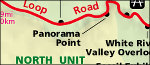
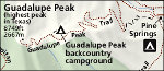 So far my Guadalupe Mountains maps page is the the shortest one since Arches. I’ve never been to Guadalupe Mountains yet, so I don’t know much about the park, but the website is pretty sparse and it seems like the park is primarily used by hikers ascending Guadalupe Peak. It does look like there’s some nice wilderness in the northern section of the park, but there’s very little info and no detailed maps I could find on the NPS website. We’ll save a more in-depth search for another day.
So although none of these pages feel incredibly finished and useful, psychologically it is nice to get a few parks done in the time it would otherwise take me to do a single park like Grand Teton. (Grand Teton will be coming shortly, featuring plenty of maps!) Originally my plan was to complete all 59 national parks before moving on to the monuments, seashores, recreation areas, parkways, memorials, etc…. but now I’m wondering whether this is the best use of my time or whether I should start including some other park sites first. Either way, I’ve just got to keep trucking along! I’ve got a great foundation, and now I’ve got to start filling things in.
 The Joshua Tree maps page took quite a while, but I got 20 maps posted, which I’m quite happy with. The maps I posted are all from the National Park Service website, although many of them have never existed in GIF or JPG formats until I created them and posted them here. So I’m happy I was able to create something new for this site.
 The Denali National Park maps page is mostly completed, although I hope to add new maps later; the NPS website didn’t have as much as I had hoped. I may need to find maps elsewhere to supplement the NPS ones. Still, the official park map is quite nice (big PDF size!) and I like the Denali Park Road map as well.
 I’ve got 17 park maps uploaded on the new
  So far the
  It maybe have taken a while, but I finally got the
  I’ve always thought
  The
The  Although the
 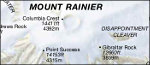 Mount Rainier is one of my favorite national parks, and my
  The new