Since the previous update, I’ve found time to finish eight new pages of national park maps, including national seashores, national lakeshores, national monuments, and national recreation areas. I’ve also substantially added to a number of current pages (e.g., Channel Islands maps), but here I’ll just highlight the new ones in chronological order:
 I’ve got seven maps on the Assateague Island Maps page – the first of many east coast beach parks to come (next expect some to the south in the Carolinas).
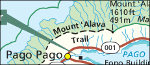 There’s also seven maps on the American Samoa Maps page. Parks covered on this site now range from American Samoa in the west to Virgin Islands in the east.
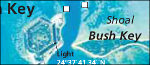 Six maps make up the Dry Tortugas Maps page, completing the south Florida trifecta with Everglades and Biscayne. Still more to come, though, such as Big Cypress.
 There are only two Cabrillo Maps so far, but I wanted to get a page finished in the southwest corner of the contiguous U.S. (The state of California is pretty well-covered by now!)
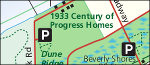 Six maps are currently on the Indiana Dunes Maps page, fleshing out the Great Lakes park system a bit more (there’s also Apostle Islands, Isle Royale, and another listed below).
 Of the seven maps on Boston Harbor Islands Maps, I really enjoy the illustrated ones of the specific islands – very unique in the realm of National Park Service map graphics.
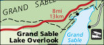 The Pictured Rocks Maps page contributes eleven more maps to parks in the Great Lakes area. Sleeping Bear Dunes will be my next big project in the area.
 Delaware Water Gap Maps bursts onto the scene with fourteen maps right-off-the-bat and marks the debut of any page in Pennsylvania and New Jersey.