Manzanar map from the park brochures
 Here is the official Manzanar map from the brochure, showing the buildings and facilities still standing (or reconstructed) and the outlines of former buildings that are no longer present.
Manzanar tour maps
 This 3D Manzanar driving tour map labels the points of interest that you’ll encounter along the auto tour route. Click the image to view a full size map or download the PDF.
 Here’s a printable tour map of Manzanar, showing some of the features along the tour route that still exist today. Click the image to view a full size map or download the PDF.
Manzanar lodging map
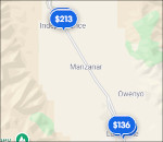
 Manzanar is located in a very remote part of the country, just as it was in the 1940s. To the right is an Expedia interactive lodging map that shows Independence and Lone Pine, the closest towns. You won’t find the biggest variety there, so you may want to zoom out and scroll up to Bishop which has more to offer. Or view Expedia’s top-rated lodging in the area to compare options in Lone Pine, Independence, Big Pine, and Bishop.
Manzanar historical maps
 Here’s a printable Manzanar map, showing the arrangement of buildings, gardens, schools, parks, guard towers, and fields as the internment camp appeared in 1944.
 This is a Manzanar block layout map, showing the typical arrangement of each of Manzanar’s blocks, including community toilets, mess halls, laundry, and recreational buildings.
Other Manzanar maps
 Here’s a United States internment camp map, showing the other internment camps in use during World War II along with their peak populations. You can see that several were even larger than Manzanar.
 The Manzanar geologic map labels all the rock types, faults, and other geologic features found nearby Manzanar National Historic Site. You can see that Manzanar was built entirely on Sierra Nevada alluvium.
…and more!
< Return to National Park Maps home
< Return to Park List
< Return to List by State