Category Archives: Updates

A solved dilemma

Every once in a while I’ll run into a strange issue when creating a new maps page. Take Sequoia maps and Kings Canyon maps, for example – how do I construct those pages? Technically the two parks are actually managed together as one park, with one website, and one series of maps – and you drive through both parks if you take the entire loop road. Yet visitors aren’t usually aware of these strange cases and think of them as separate. So, I ended up creating two pages, just with duplicate maps.

Glen Canyon mapToday I had a new dilemma – what to do about Glen Canyon National Recreation Area? It makes sense to create a Glen Canyon maps page, since that’s what the park is called. Unfortunately, most visitors don’t know it as Glen Canyon – it’s just “Lake Powell.” So, maybe I should create a Lake Powell maps page instead?

Lake Powell Wahweap color mapI ended up creating both, but removing a few maps on the Lake Powell maps page that focused elsewhere in Glen Canyon National Recreation Area (such as Lees Ferry). I think this makes the most sense and hopefully won’t be too confusing for users. Thus, there’s an entry for both Lake Powell maps and Glen Canyon maps in the navigation menu.

I also added a lot of new maps to Mesa Verde maps, Capitol Reef maps, and Carlsbad Caverns maps. Check them out! I’m up to 710 maps total now. (And yes, that’s without double-counting both Glen Canyon and Lake Powell – it was tempting to double count to increase my total number, but I just can’t handle the dishonesty!)

And now for something completely different

For once, this update isn’t about a new page that I’ve created. (Although I added a bunch of maps to both Cuyahoga Valley Maps as well as Yosemite Maps.) Instead, I’m sharing a random chart that might interest no one but myself, but I was curious enough to create it so I figured I might as well share it.

Below you see the number of park maps I’ve uploaded since I created my site in October 2013. Not surprisingly, you see a huge jump at the beginning, as I created many pages all at once. I continued slowly adding during spring of 2014, and then you notice about a year of nothing – life got busy! In early 2015 I added a few more, and then again in August 2015. And you’ll see that now, at the beginning of 2016, I’ve renewed my dedication and have zoomed past both the 500 and 600 marks; I’m currently at 677 total maps. (I keep a count on the site home page.)
Total park maps over time

Anyway, nothing too profound I realize, but I had fun checking out the numbers all the same. Thanks for humoring me!

Devils Postpile, Cape Hatteras, and Lava Beds are live!

I have a new update for you of another three parks – two national monuments and a national seashore. I find right now I’m still picking away at the coasts, but realize I still have lots to do in the middle of the country. The California list is especially getting long; if you check out the List by State page you’ll see no other state comes anywhere near California so far. Let me know by leaving a comment down below or contact me if you have a request for what you’d like to see next.

Devils Postpile map
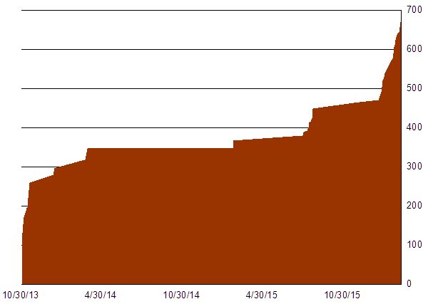
My second recent addition of a park featuring the word “Devil” – four maps on the Devils Postpile Maps page are live. Next to add some maps of the nearby Ansel Adams Wilderness…

Cape Hatteras mapAs promised earlier, I got some more work on the Atlantic coast with the five maps on my Cape Hatteras Maps page. There are still some more coastal parks coming up!

Lava Beds Cave Loop Road mapAnd a small but underrated park in northern California is now featured – check out the seven maps on the Lava Beds Maps page. Caves and lots of lava? Great park.

Thanks to everyone for using my site; in February I received over 12,000 page views for the first time in a single month. It’s been very gratifying to know people are finding me and are having an easier time planning their trip.

Eight new pages of a few different park types

Since the previous update, I’ve found time to finish eight new pages of national park maps, including national seashores, national lakeshores, national monuments, and national recreation areas. I’ve also substantially added to a number of current pages (e.g., Channel Islands maps), but here I’ll just highlight the new ones in chronological order:

Assateague Island detail mapI’ve got seven maps on the Assateague Island Maps page – the first of many east coast beach parks to come (next expect some to the south in the Carolinas).

American Samoa mapThere’s also seven maps on the American Samoa Maps page. Parks covered on this site now range from American Samoa in the west to Virgin Islands in the east.

Dry Tortugas mapSix maps make up the Dry Tortugas Maps page, completing the south Florida trifecta with Everglades and Biscayne. Still more to come, though, such as Big Cypress.

Cabrillo mapThere are only two Cabrillo Maps so far, but I wanted to get a page finished in the southwest corner of the contiguous U.S. (The state of California is pretty well-covered by now!)

Indiana Dunes map
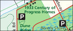
Six maps are currently on the Indiana Dunes Maps page, fleshing out the Great Lakes park system a bit more (there’s also Apostle Islands, Isle Royale, and another listed below).

Boston Harbor Islands map - Georges IslandOf the seven maps on Boston Harbor Islands Maps, I really enjoy the illustrated ones of the specific islands – very unique in the realm of National Park Service map graphics.

Pictured Rocks mapThe Pictured Rocks Maps page contributes eleven more maps to parks in the Great Lakes area. Sleeping Bear Dunes will be my next big project in the area.

Delaware Water Gap mapDelaware Water Gap Maps bursts onto the scene with fourteen maps right-off-the-bat and marks the debut of any page in Pennsylvania and New Jersey.

Huge update! Eleven new parks added

I’ve got 2016 off to a strong start! Not only have I updated a number of pages with new maps (such as Olympic, Grand Canyon, Theodore Roosevelt, and more), but I’ve got 11 new pages created from scratch. Here’s the rundown:

Congaree National Park mapThe Congaree maps page has 2 maps – both a full park map and a detailed hiking trail map.

Mount Rushmore detail mapThe Mount Rushmore maps page has 3 maps, ranging from a map of the Black Hills to a detailed map of the memorial area.

Muir Woods trail and topo mapSo far there are 3 Muir Woods maps on the Muir Woods National Monument page, including two detailed trail maps.

Point Reyes MapI’ve got 11 Point Reyes maps, especially highlighting the backcountry wilderness areas and campsites.

Apostle Islands mapHere are 8 Apostle Islands maps, highlighting trails and camping areas on the islands in Apostle Islands National Lakeshore.

Ellis Island mapThe Statue of Liberty maps page features 4 maps of both parts of Statue of Liberty National Memorial, including Ellis Island.

Devils Tower mapHere are 3 Devils Tower maps – the official park brochure map, a geologic map, and a topographic map.

Kennesaw Mountain mapThere are 5 maps on the Kennesaw Mountain maps page; the best three are the trail maps highlighting each area of the park.

Cedar Breaks mapThe Cedar Breaks maps page has 5 maps, including four detailed maps of the surrounding region in Dixie National Forest.

Craters of the Moon mapThere are 7 Craters of the Moon maps, highlighting campgrounds, trails, and detailed road maps.

Bandelier mapI’ve uploaded 6 Bandelier maps, with everything from campground layouts to trail and regional maps.