Since my last update, I’ve added another five parks to this site. But before I introduce those pages as I traditionally do in these updates, I wanted to instead share with you a couple non-map pages I’ve created. The first is Operation: Thank A Ranger.
OK, maybe that’s a silly name. Whatever. I created this new page after receiving an email last week from a site visitor that included the following:
My fellow co-workers and I are concerned about the future of our national parks — specifically regarding their funding and land protection. We are finding ways/places to donate both our time and money to help preserve and support — do you have any favorites or suggestions?
I pondered on this for a while, trying to avoid responding with the traditional “volunteer for x, support organization y.” Eventually I came up with what I thought was a nice idea, replied to the email, and went on about my life.
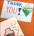 But I soon realized my idea would work much better if a critical mass was reached. I wanted to share my idea with others, so I got to work, spent hours organizing and compiling links, and put together my new Thank A Ranger page. Check it out! I won’t repeat that whole page here, but the gist is that I’d love it if we could show our support to park employees by writing them letters of support and appreciation — helpful reminders for those dealing with record crowds and questions about the future of their agency.
On the Thank a Ranger page you’ll find links to the contact information of every national park, sorted by state. In case you’d rather see a full list of parks alphabetically, I also created the Contact A Park page. This page should be super-helpful for those of you want to have official brochures and maps sent to your home, as parks will generally send those upon request. Keep these two pages handy and you’ll be able to get your trips planned faster.
OK, enough blabbing — what new pages have I created?
 Flight 93 Maps. Did you even know Flight 93 National Memorial existed? As you can imagine, it’s one of our newer national park units, and the only one related to the tragic events of September 11, 2001.
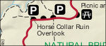 Natural Bridges Maps. If you’re looking for dark night skies, Natural Bridges National Monument may be your best bet as the first International Dark Sky Park.
 San Antonio Missions Maps. I’ve finally got so many large natural park pages uploaded that I get to spend time working on historical parks! Stay tuned for a much larger percentage of them from here on out.
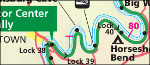 C&O Canal Maps. Like this one. Although many visitors go to the C&O Canal for running, biking, and outdoor activities, the park actually protects the historic canal and towpath, so important in the 1800s.
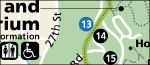 Rock Creek Park Maps. And I always have a soft spot in my heart for urban parks such as Rock Creek. Not everyone can afford to travel to large western parks; here, the rangers can come to them.
That’s it for this update! As a reminder, you can keep abreast with the latest updates here by following me on Facebook or on Twitter.
 I’m making more progress on Arizona parks, with
  And yes, I did complete the last of the three Flagstaff-area parks with
  You’ll find 31 maps on the
  I was very pleased to finally get a Louisiana park on the board: Jean Lafitte National Preserve. You can find 10
 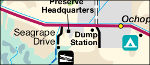 South Florida is pretty much all parkland. Finally, I’ve got 12
  There’s a weird little quirk about my new
 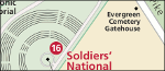 I realize I’m still lacking on Civil War sites. Sure, I’ve got
  Yay, Kansas! I hadn’t forgotten you. Now you can go back in time and imagine what the Great Plains used to look like after getting some
  I was also happy to get West Virginia another page, especially since
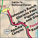
 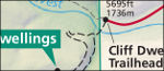 Traveling back out west, we find New Mexico’s embarrassment of riches.
 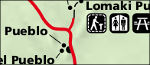 Then you have Arizona showing up even New Mexico, as
  Next door to Wupatki you’ve got Sunset Crater Volcano National Monument. So I couldn’t do Wupatki without getting a
  And back east again,
  So, what’s the single new page? One of the most important and relevant park sites for today’s world: Manzanar National Historic Site, an internment camp where Japanese-Americans were sent during Word War II. Check out the eight maps I’ve got on the
  Rainbow Bridge Maps
 I’ve also added new maps from a bunch of park wayside exhibits: you’ll find some battle maps on the
  and aerial photography maps on