I wanted to get some geographic diversity with this next update, so say hello to my newest three pages!
 Honestly I’m wondering if creating the new Fire Island maps page was sort of a waste of time – is anyone honestly ever looking for maps of Fire Island? This isn’t exactly a destination park, but a locals park. Who’s really going online to find maps? Either way, I’ve grabbed 7 maps for this one.
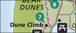 The Sleeping Bear Dunes maps page was a long time coming – I should have created this one a while ago. Some of the best backpacking and hiking in the state of Michigan and it took me this long? The 24 maps I found for Sleeping Bear helped me complete the upper-Midwest lake series – Apostle Islands, Indiana Dunes, Pictured Rocks, and Isle Royale. (I suppose you could throw Voyageurs into there as well.)
 Maybe the most underrated park in the country is Dinosaur National Monument. So enjoy the 14 Dinosaur maps of some pretty spectacular country. Here’s one park I think should be upgraded from National Monument to National Park – if Dinosaur isn’t national park-worthy, I don’t know what is. One of the best!
Besides the new pages, I’ve also uploaded and saved as JPG a number of USGS topos for a bunch of different parks – Acadia, Mount Rainier, Crater Lake, Zion, and Grand Canyon. More coming! It’s just pretty time-consuming to find, convert, and upload these maps compared to others, so it hasn’t been on the top of my list. More later!