Yellowstone maps from the park brochures
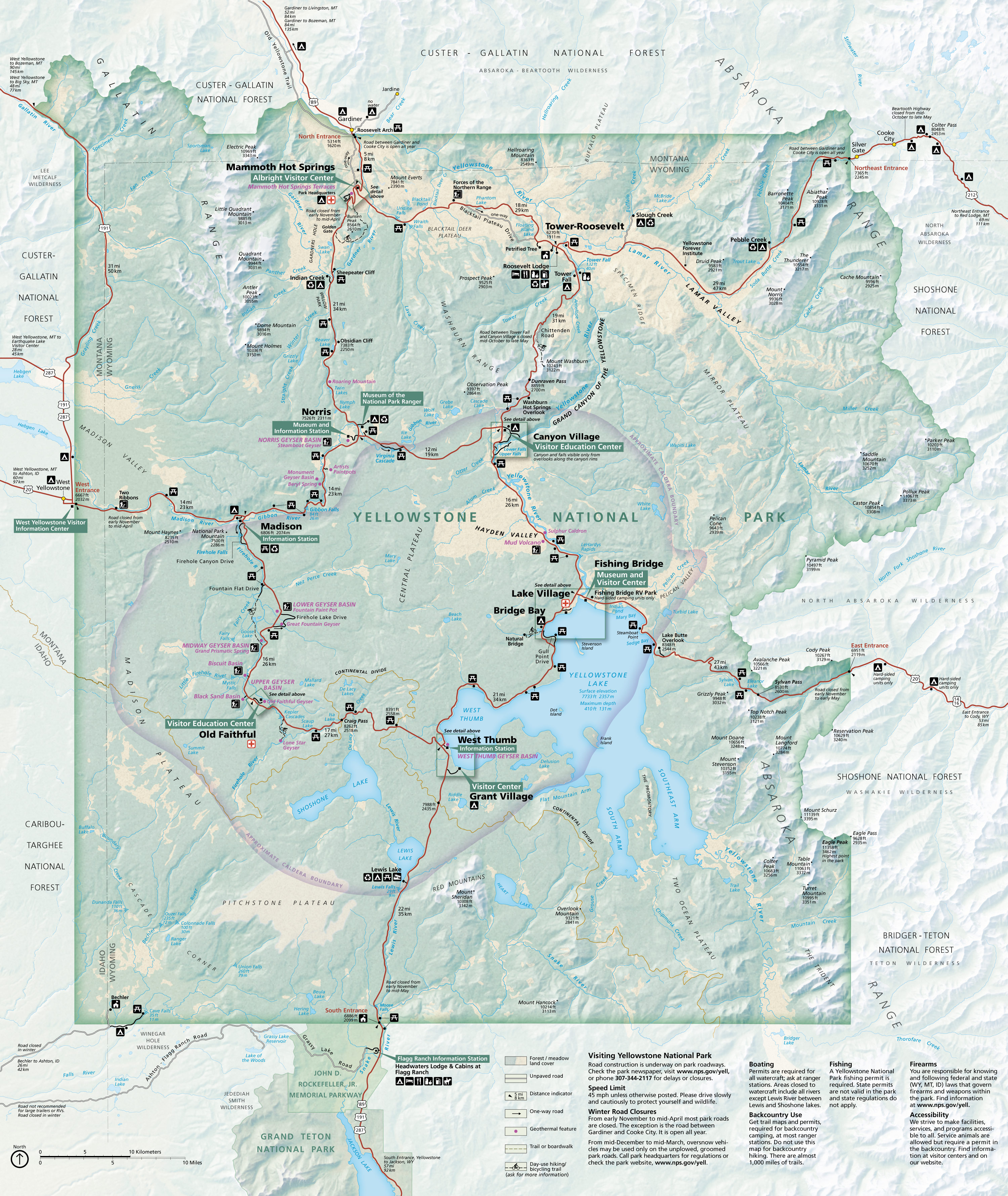
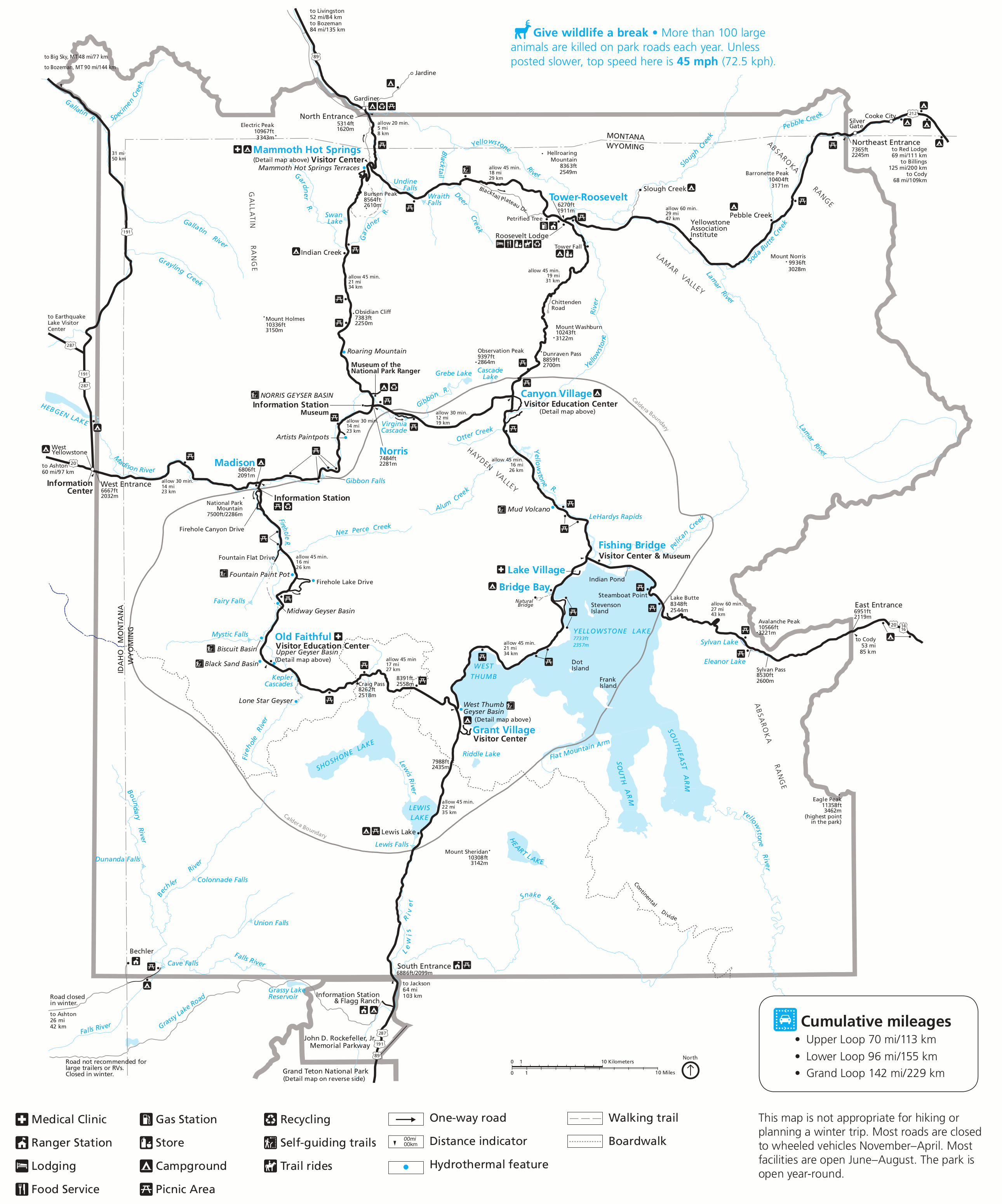
 This is the official Yellowstone National Park map, last updated after the floods of 2023. It shows the new route in to Mammoth from Gardiner and has other assorted updates. Click the image to view a full size map.
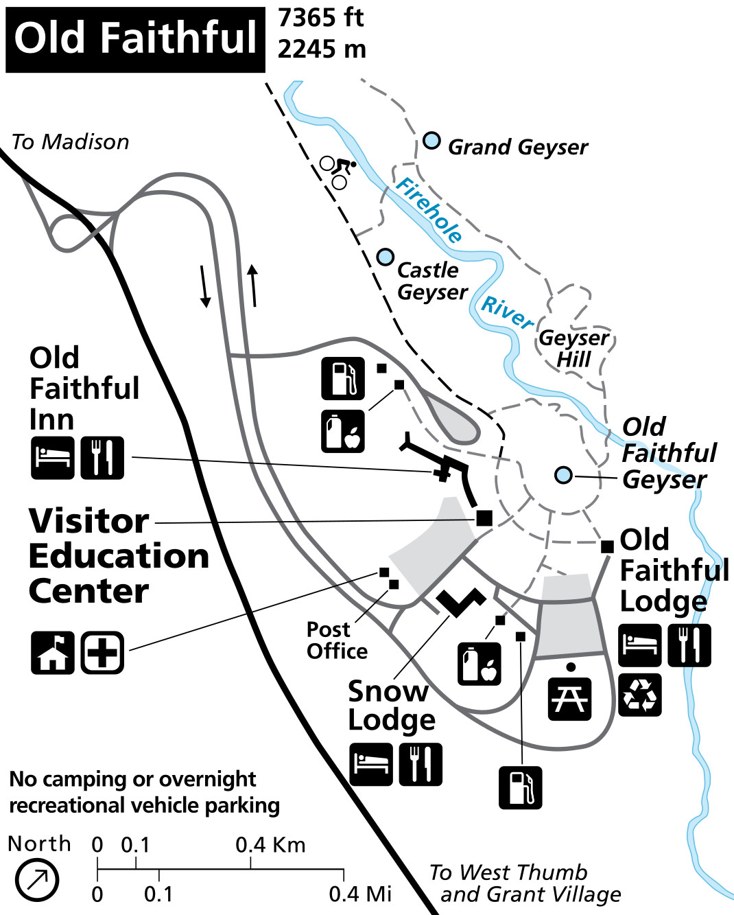
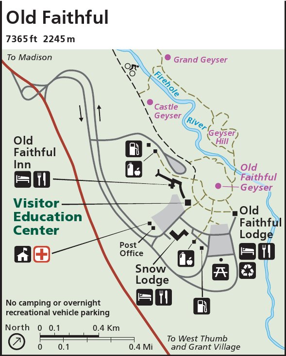
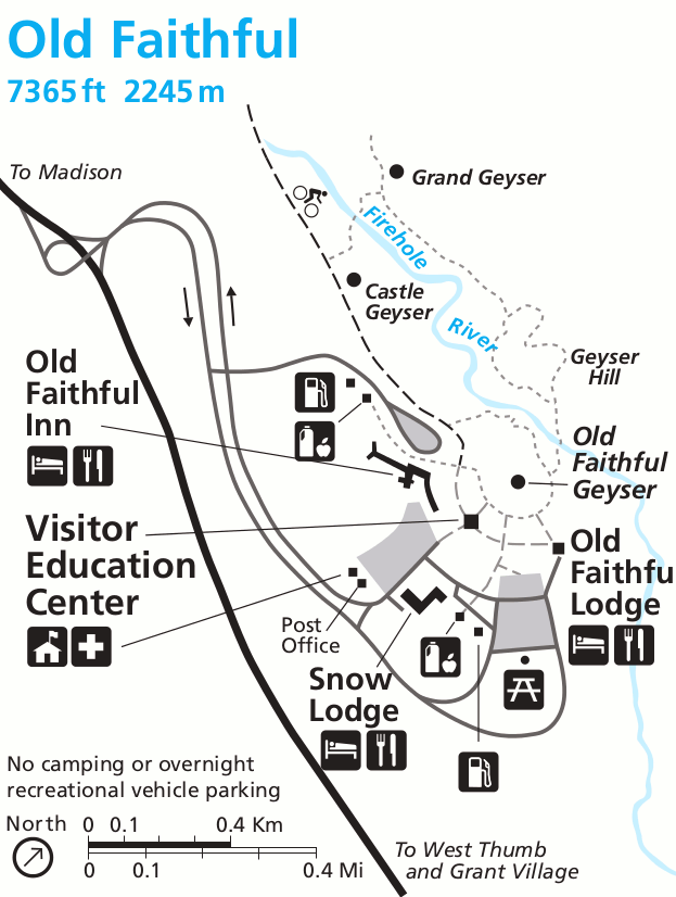
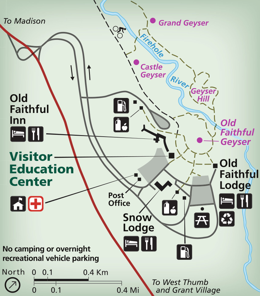 Here’s an Old Faithful area map, which zooms in on the Upper Geyser Basin trails and services immediately surrounding Old Faithful. See the exact locations of the Old Faithful Inn, Snow Lodge, and Old Faithful Lodge.
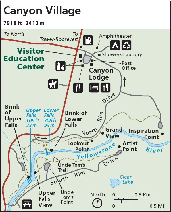
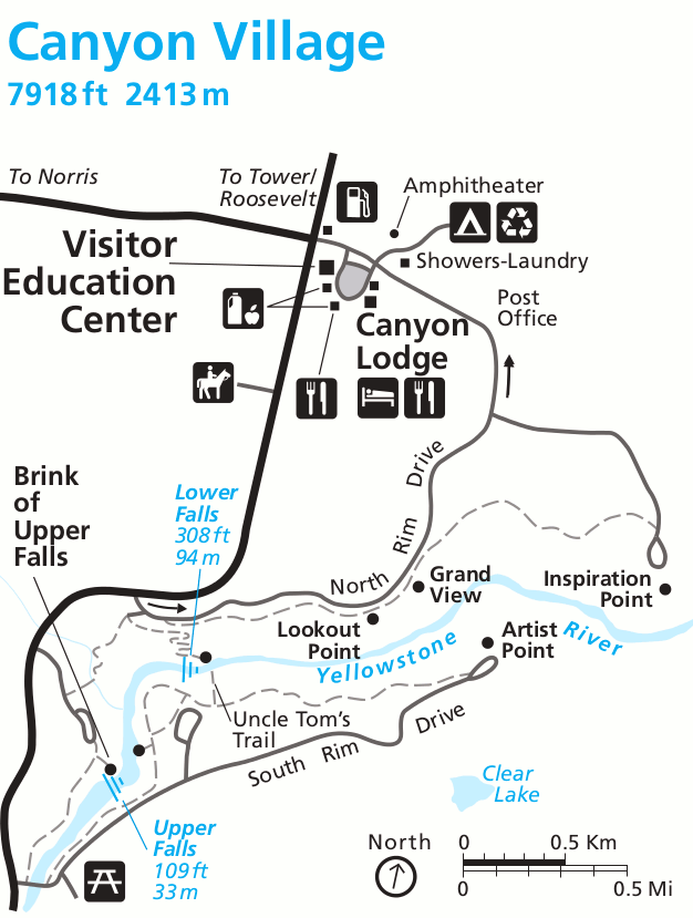
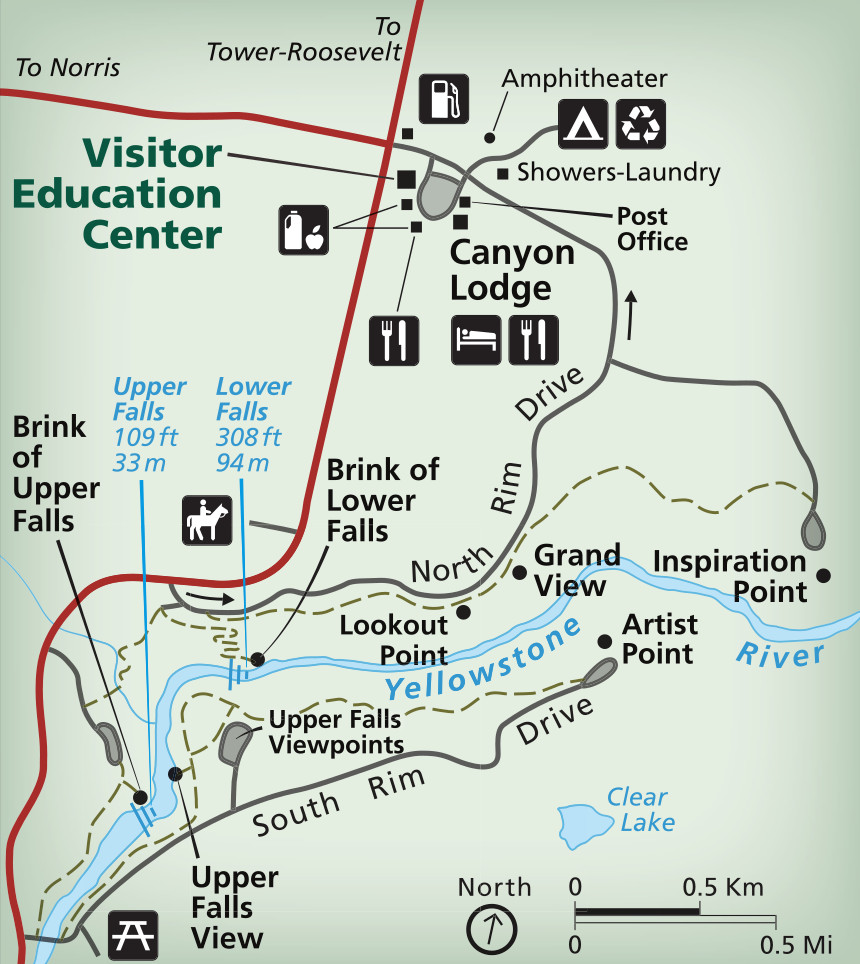 This Canyon Village map includes both the services near the Grand Canyon of the Yellowstone (lodge, visitor center, cabins, restaurants) and trails and viewpoints like Grand View, Artist Point, and Inspiration Point.
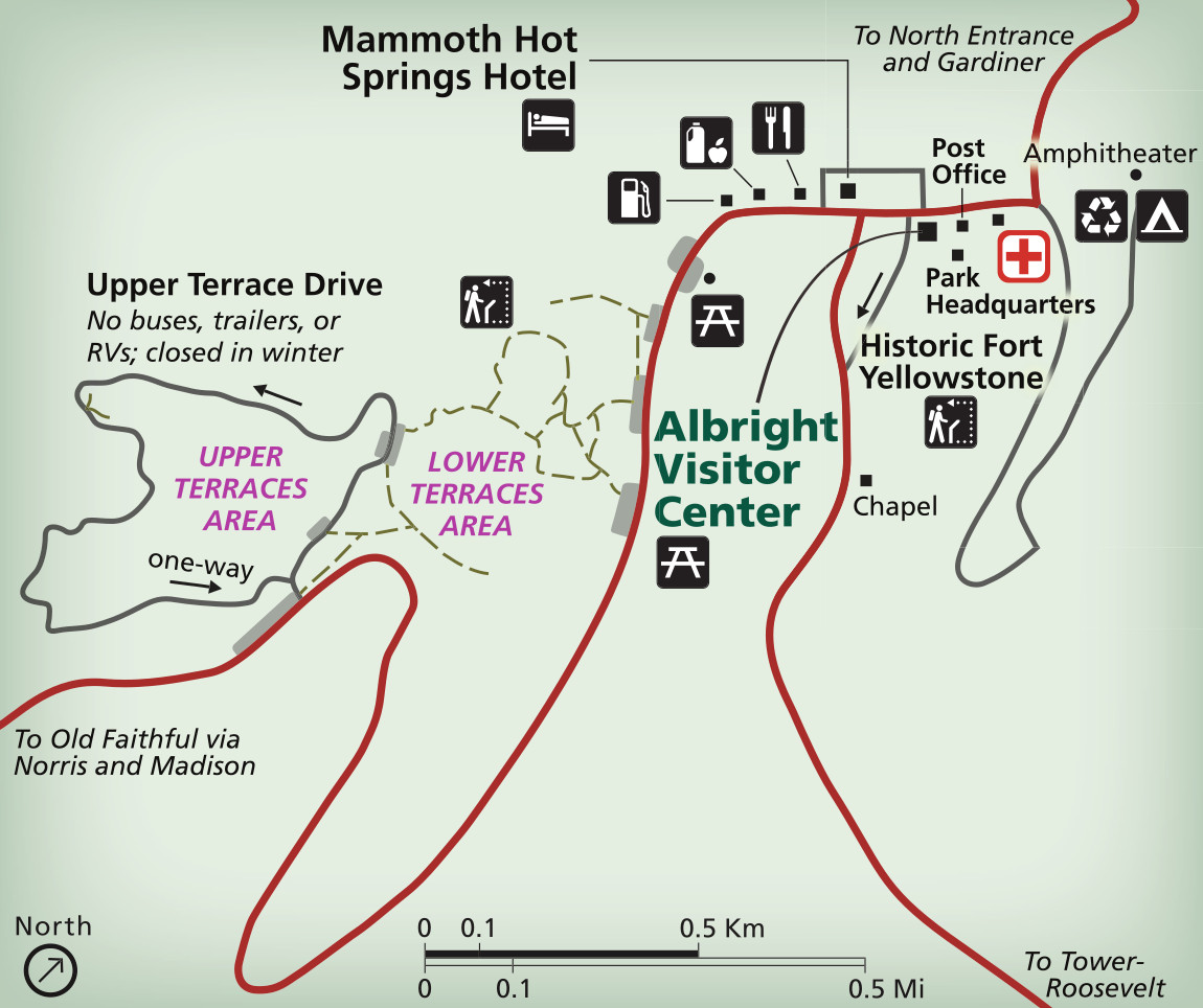 The Mammoth Hot Springs map shows both the trails near the terraces and the services around the Mammoth Hot Springs Hotel. Note the new road alignment to Gardiner in response to the 2023 floods.
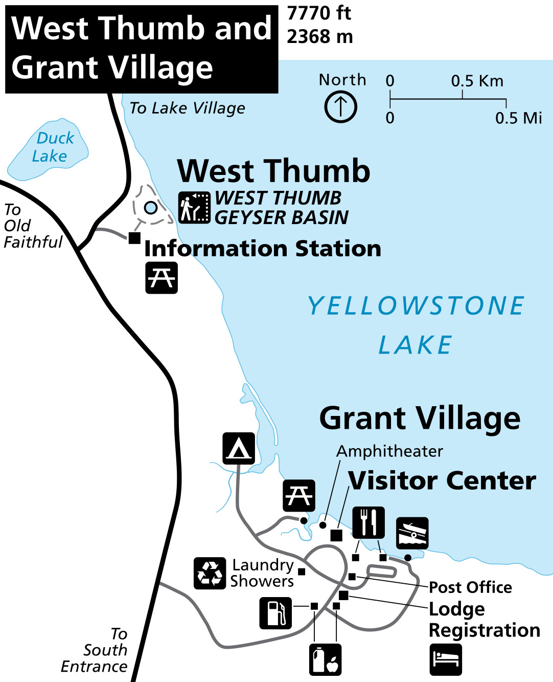
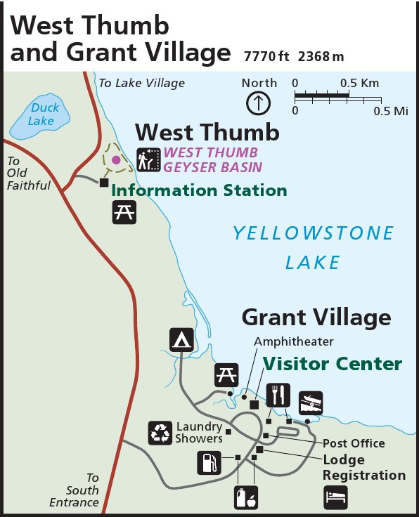
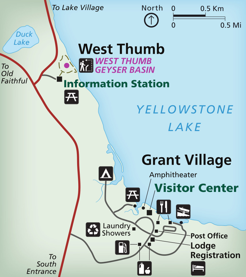 Here’s a Grant Village map, showing the concentration of facilities in Grant Village such as the visitor center, campground, lodge, and more. It also includes the West Thumb Geyser Basin just to the north.
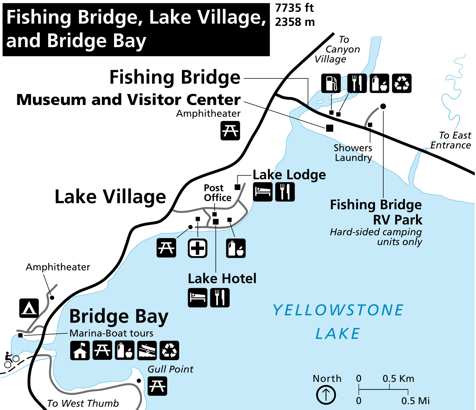
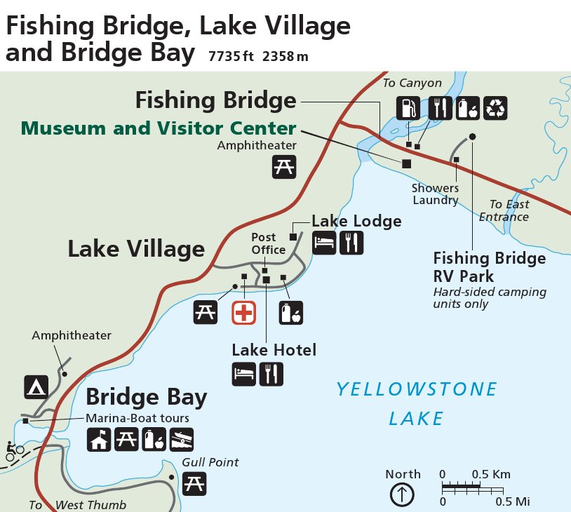
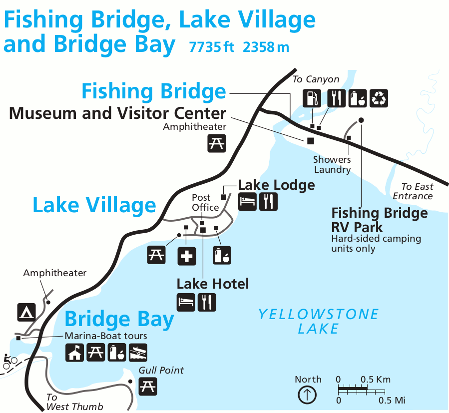
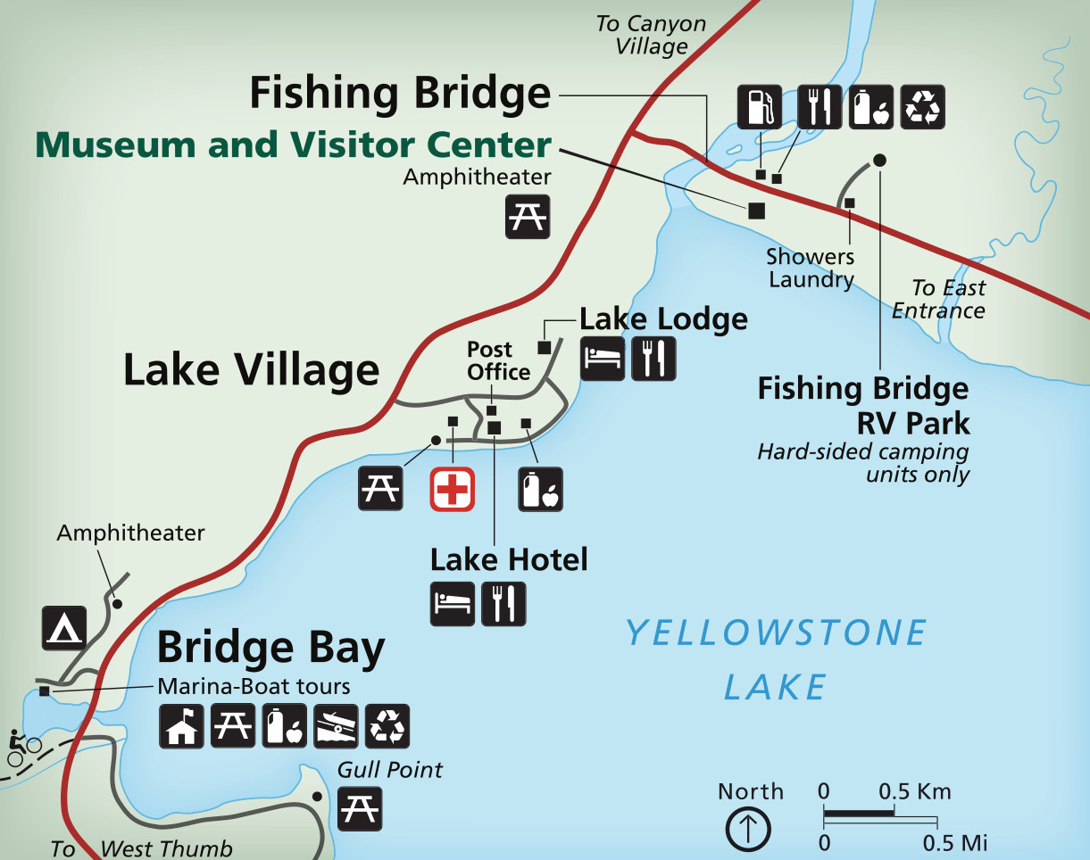 The Lake Village map shows the immediate area surrounding the grand Lake Hotel and Lake Lodge. You’ll also see details of the Bridge Bay area to the southwest and Fishing Bridge area to the northeast.
 The combined set of Yellowstone area maps combines the five detail maps above into one. It also provides a legend to identify map icons. Click the image to view a full size map or download the PDF.
Yellowstone trail maps
 If you’re looking for a map of hiking trails outside of the major geyser basins, you’ll need to buy a hiking map like the National Geographic Trails Illustrated map. Nat Geo also publishes a set of more-detailed Yellowstone maps and sells them as a bundle of four maps. Or, if you’re also visiting Grand Teton National Park, you can save money by buying the Yellowstone/Grand Teton map pack, covering both parks.
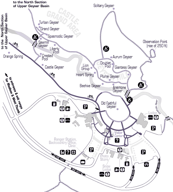 This is an Old Faithful trail map, showing the trails, boardwalks, geysers, and thermal features in the southeastern part of the Upper Geyser Basin, nearest Old Faithful Geyser.
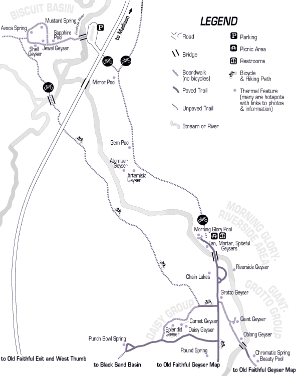 Here’s another Old Faithful area trail map, showing the northwest continuation of the previous map, including Riverside Geyser, Giant Geyser, Morning Glory Pool, and the Biscuit Basin.
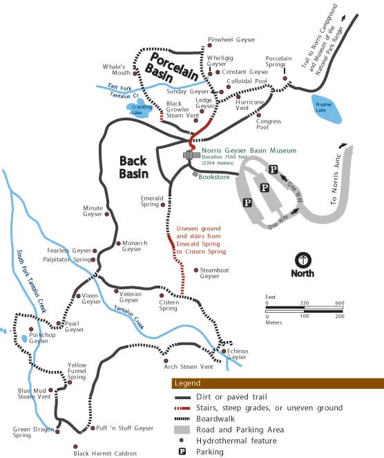 This is a Norris Geyser Basin trail map, showing geysers and hot springs in both the Porcelain Basin and Back Basin. This is the most dynamic geyser basin in Yellowstone – be prepared for trail reroutes!
 This is a Mammoth Hot Springs trail map, showing the terraces, springs, trails, and boardwalks in the Mammoth Hot Springs area. Come back again and see how the terraces change!
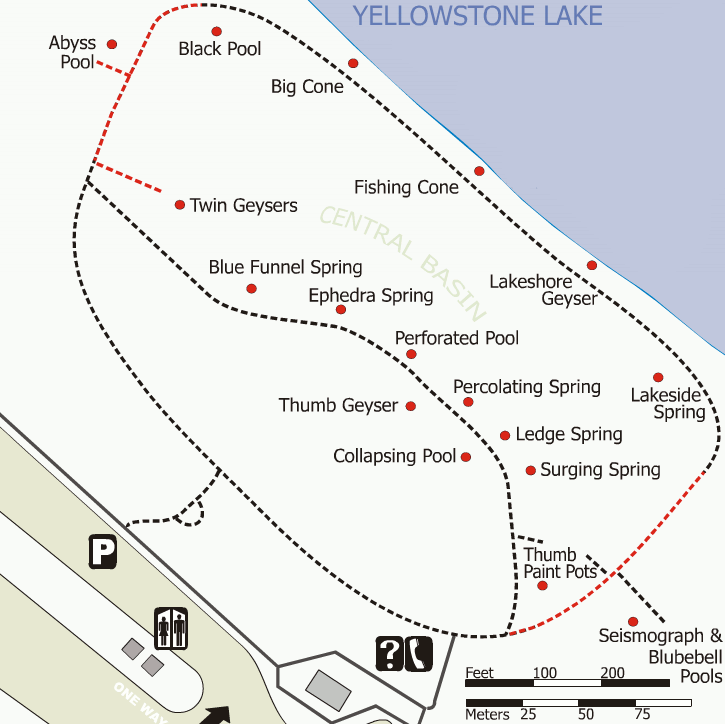 Here’s a West Thumb Geyser Basin trail map, showing the geysers and thermal features such as Fishing Cone on the west shore of Yellowstone Lake near Grant Village.
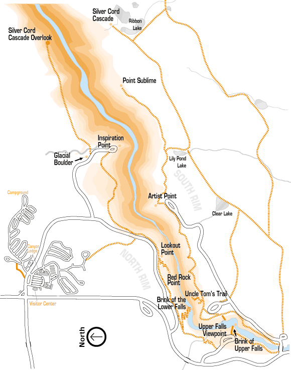 Here’s a Grand Canyon of the Yellowstone trail map, showing the trails accessing both Upper and Lower Falls. If you’re feeling brave, give Uncle Tom’s Trail a try! Or enjoy the falls from afar.
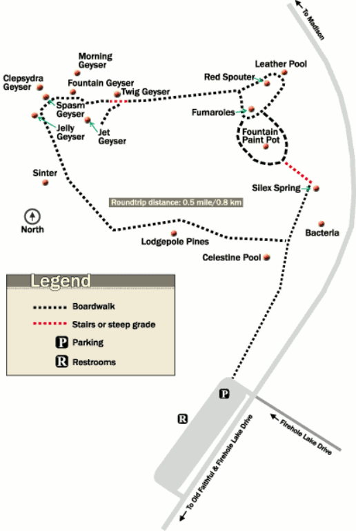 This is a Fountain Paint Pot trail map, showing the trails surrounding the Fountain Paint Pots and thermal features in the Lower Geyser Basin, including popular Clepsydra Geyser.
Other thermal area maps
These maps are from photos I took of signs and brochures during my last Yellowstone trip:
 The Midway Geyser Basin map comes from the sign at the beginning of the trail from the parking lot and shows the boardwalk past Excelsior Geyser and Grand Prismatic Spring.
 The Black Sand Basin map comes from the sign at the beginning of the Black Sand Basin trail and identifies major features such as Emerald Pool, Cliff Geyser, Rainbow Pool, and Sunset Lake.
 This Mammoth Hot Springs Lower Terrace map is a photo I took of the sign located at the bottom of the terraces, showing the boardwalk and accessible trail to view the hot springs.
 This is a Mammoth Hot Springs Lower Terrace overhead map. I took this photo of a sign along the Upper Terrace Drive showing the lower terrace boardwalks as they’re accessed from the nearby parking area.
 Here’s a Mammoth Hot Springs Upper Terrace map, showing the sign located at the entrance to the one-way Upper Terrace Drive and naming features such as Orange Spring Mound and Angel Terrace.
Yellowstone lodging map
 The highest concentration of hotels is in West Yellowstone; you can view an Expedia interactive West Yellowstone lodging map on the right. But there are many more places you can stay: Gardiner, MT provides quickest access to the North Entrance and there’s lodging inside the park too. So you may want to browse all of Expedia’s top-rated Yellowstone lodging where you can compare reviews, photos, and prices.
Yellowstone landscape maps
 This beautiful Yellowstone landscape map shows all of Yellowstone (and even the Tetons!) from an oblique aerial perspective, originally painted by Austrian artist Heinrich Berann for the National Park Service.
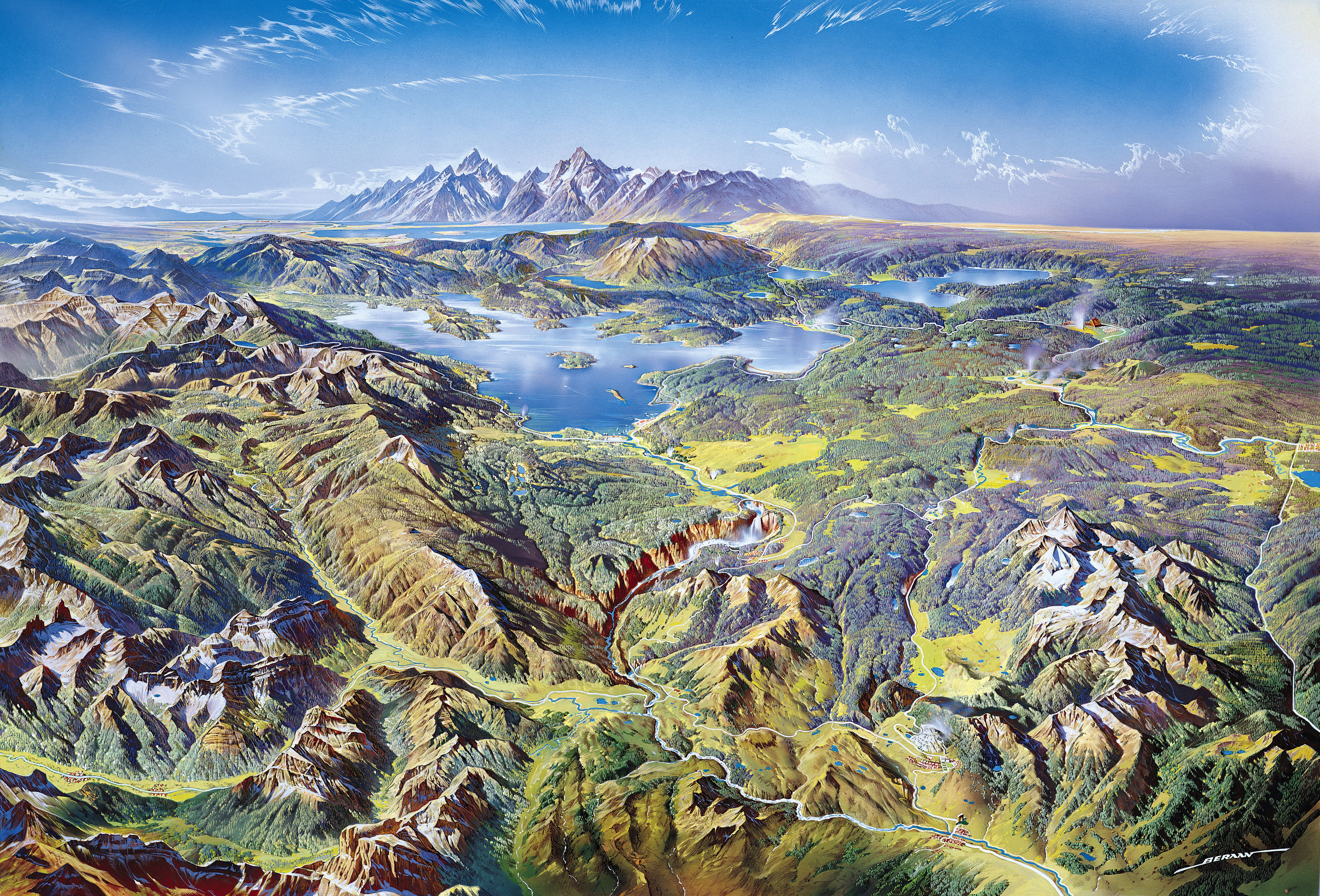 This unlabeled Yellowstone landscape map is the same as the painting above, but removes all the labels for a more naturalistic perspective on Yellowstone’s natural features and landforms.
Regional Yellowstone maps
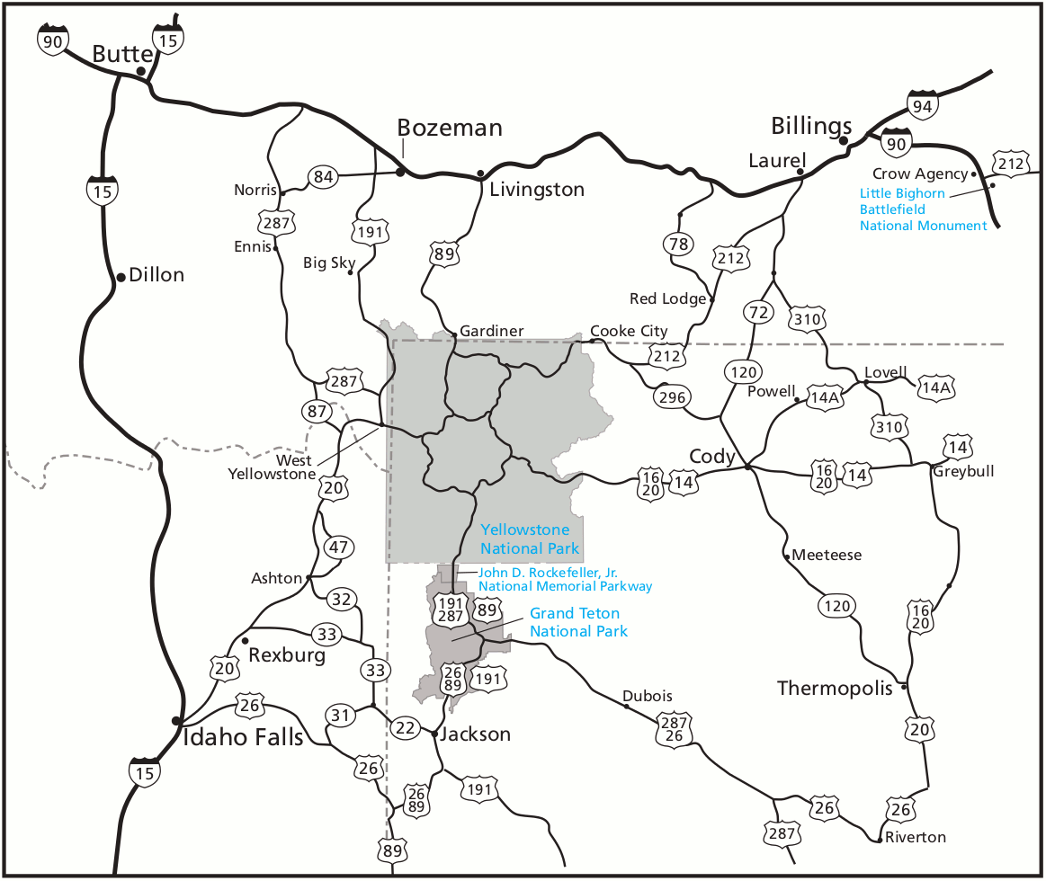 Here’s a regional road map of Yellowstone, showing the major and local highways that can get you to Yellowstone and Grand Teton National Park from surrounding Montana, Wyoming, and Idaho.
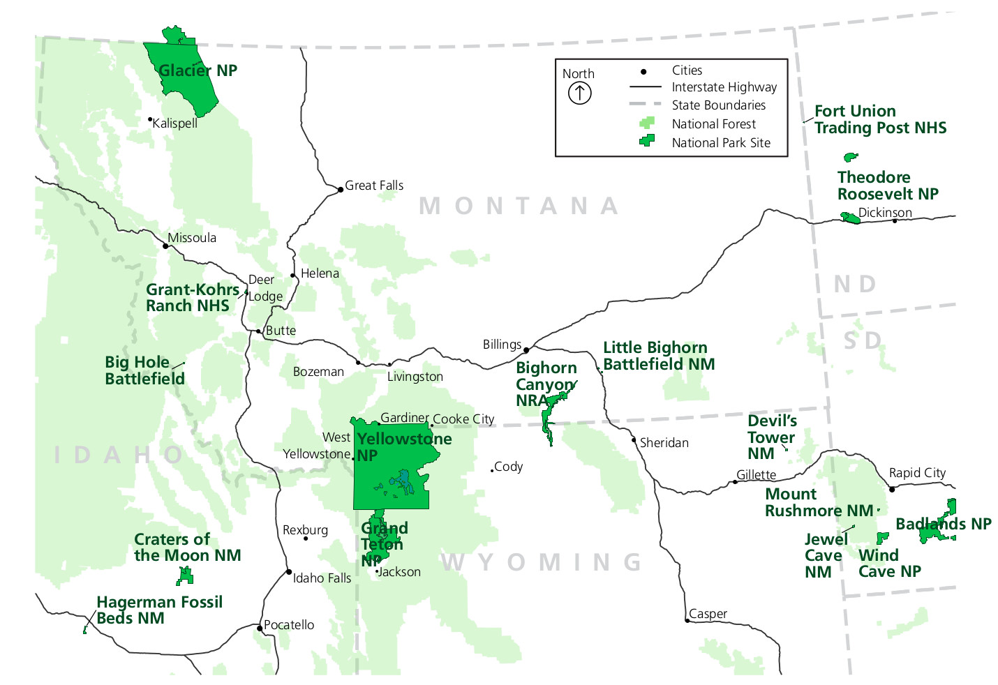 This regional park map of Yellowstone focuses mostly on the national parks in the states surrounding Yellowstone (and includes some major highways). This map is great for road-trip planning!
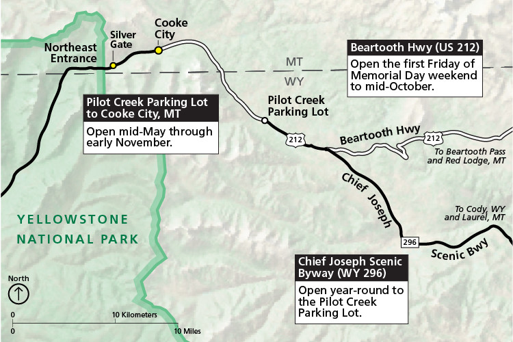 This Northeast entrance area map shows both the Beartooth Highway and Chief Joseph Scenic Byway. These two incredibly scenic roads are open only during summers; otherwise access to Cooke City is via the park.
Yellowstone backcountry maps
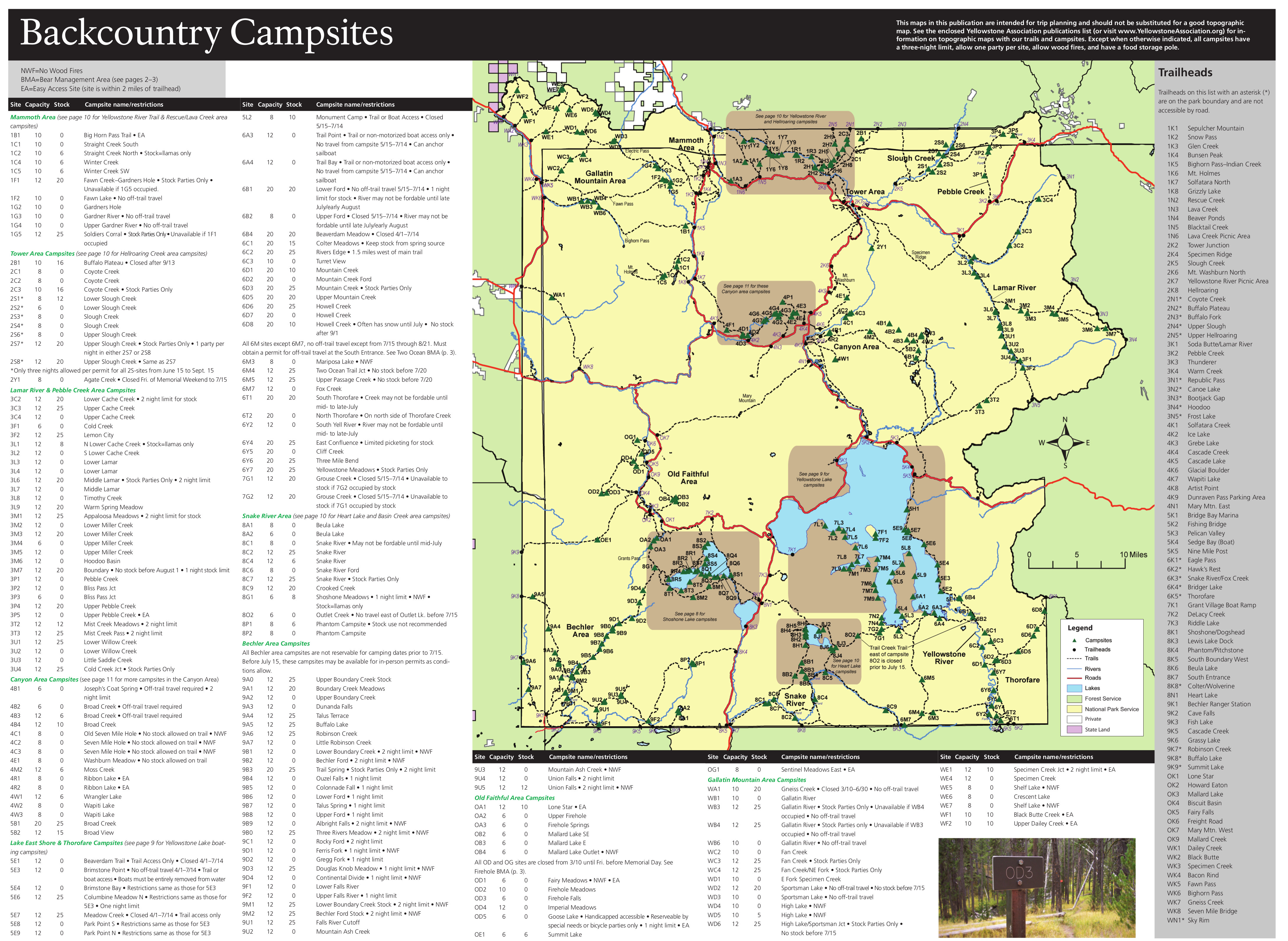 Here’s a Yellowstone backcountry map, including labels and descriptions for each backcountry campsite. The five maps below zoom in on specific areas in the Yellowstone backcountry.
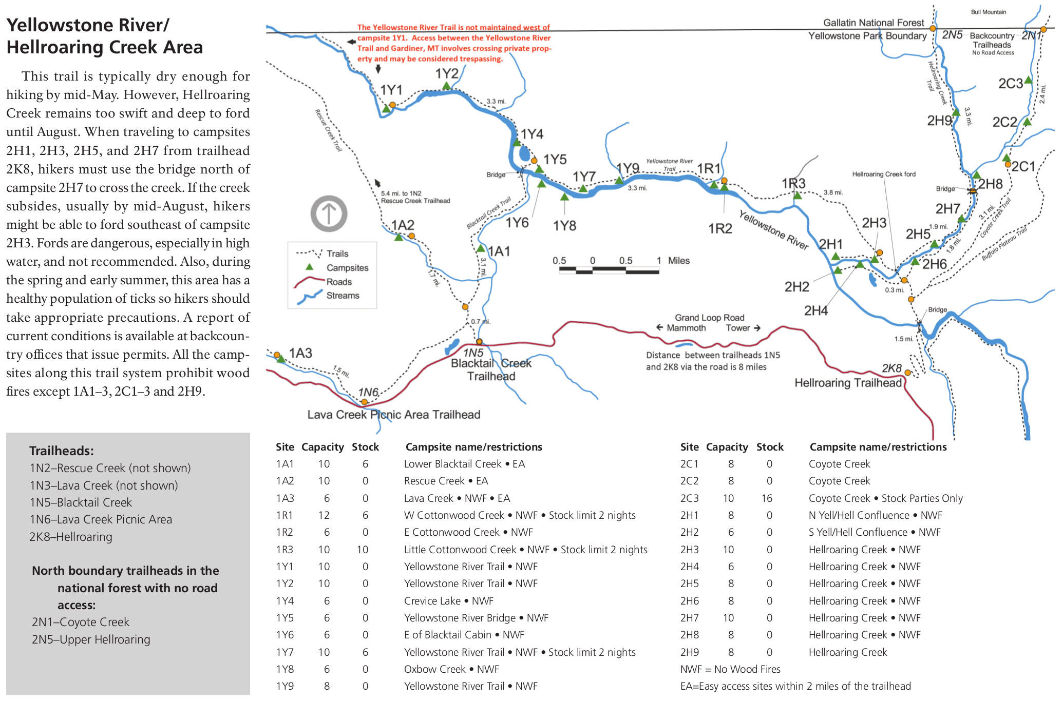 The Yellowstone River backcountry map includes the trails and campsites in northern Yellowstone near Hellroaring Creek and the Yellowstone River upstream of Gardiner, MT.
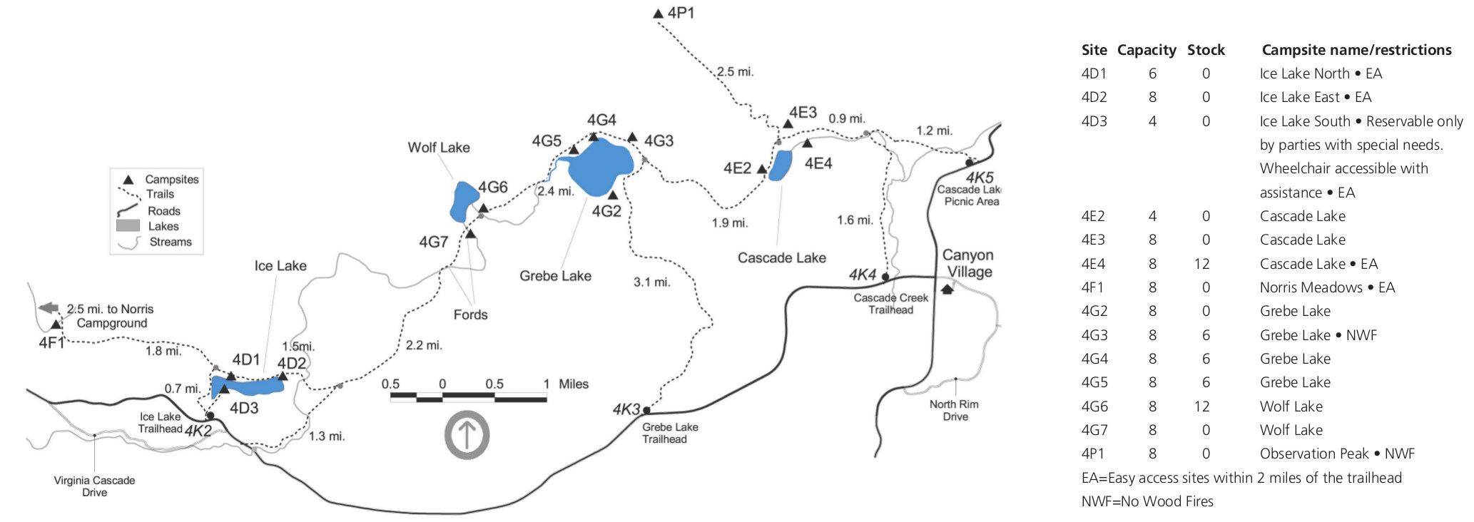 This Canyon area backcountry map shows the campsites and trails located west of Canyon Village and north of the loop road – near Ice Lake and Wolf Lake, Grebe Lake, and Cascade Lake.
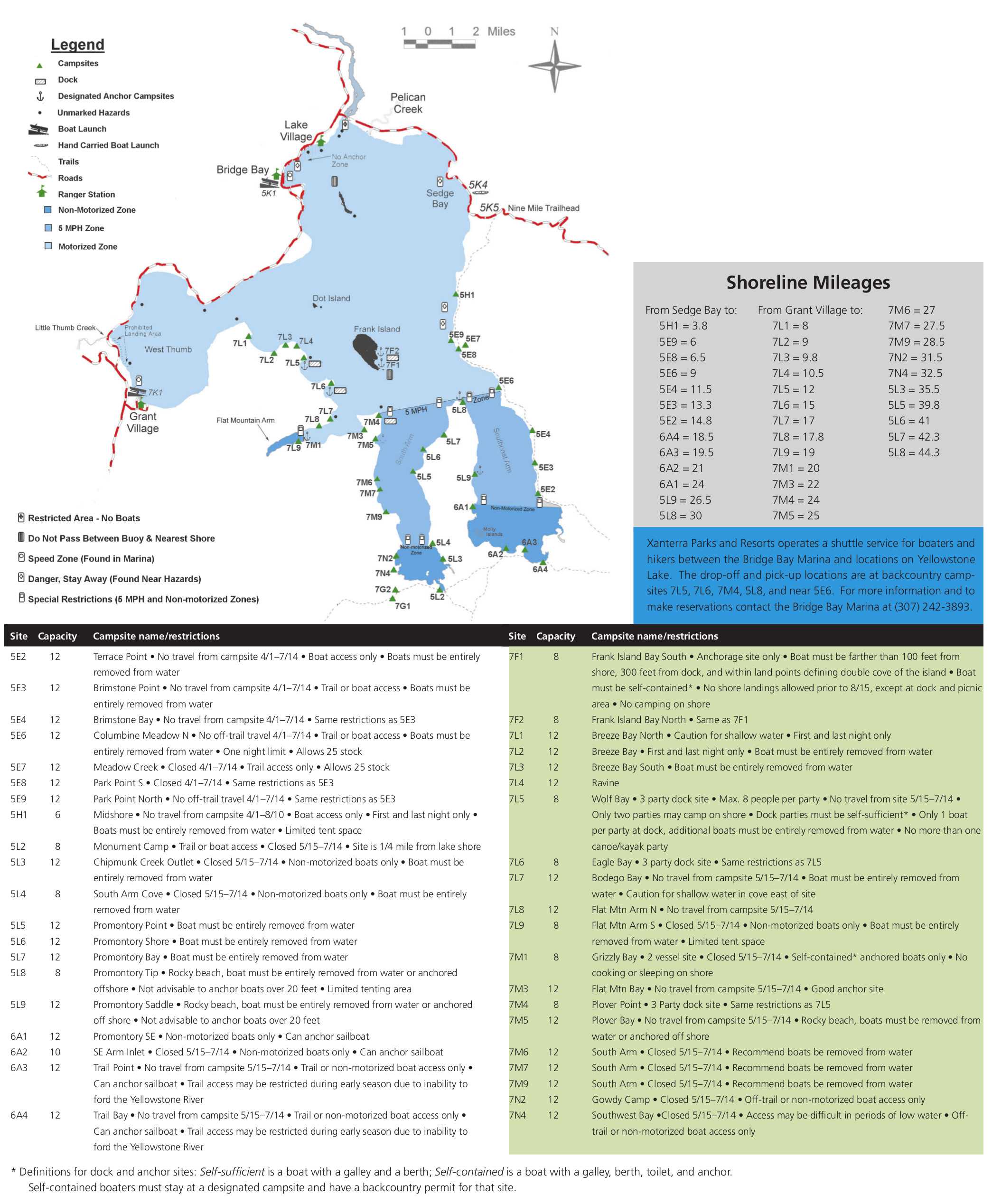 The Yellowstone Lake backcountry map features the campsites lining the shores of Yellowstone Lake, many of which are accessible only by water. Also included are descriptions for each campsite.
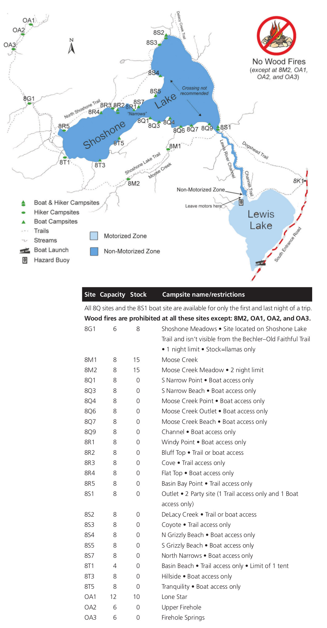 Here’s a Shoshone Lake backcountry map, showing the campsites and trails around Shoshone Lake in the southwest part of Yellowstone, upstream of Lewis Lake.
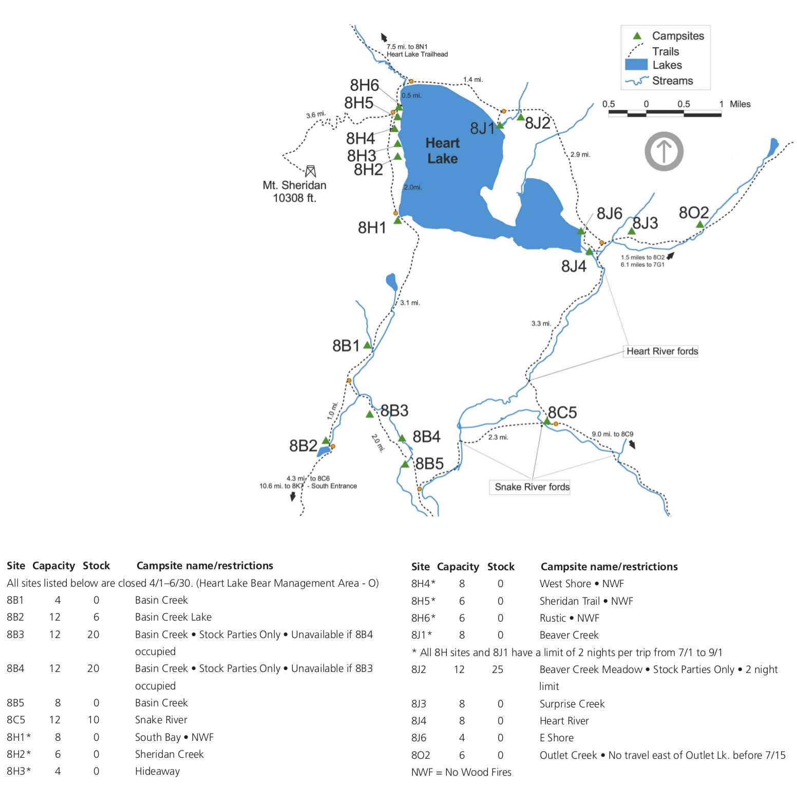 The Heart Lake backcountry map focuses on Heart Lake campsites and the surrounding trails, located south of Yellowstone Lake and east of the loop road.
The maps above are all great for trip planning, but they’re definitely not suitable for backcountry travel. You instead need a waterproof topographic map like one from the National Geographic Trails Illustrated series. You can get specific quadrant maps if you’ll only be in a certain part of Yellowstone (Old Faithful, Mammoth Hot Springs, Tower/Canyon, Yellowstone Lake) or purchase the bundle of four maps that cover the entire park.Yellowstone winter maps
 This is the Yellowstone winter roads map, showing which roads are open and closed during the winter season for cars or oversnow vehicles such as snowmobiles. Note that this map was last updated before the 2023 floods.
 The Old Faithful area winter trails map shows the groomed ski and snowshoe trails surrounding the Snow Lodge at Old Faithful and labels them according to difficulty level.
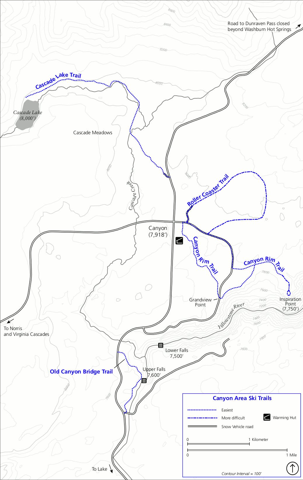 The Grand Canyon of the Yellowstone winter trails map shows the ski trails to the rim of the canyon at Inspiration Point and Grandview Point, as well as other ski trails like to Cascade Lake.
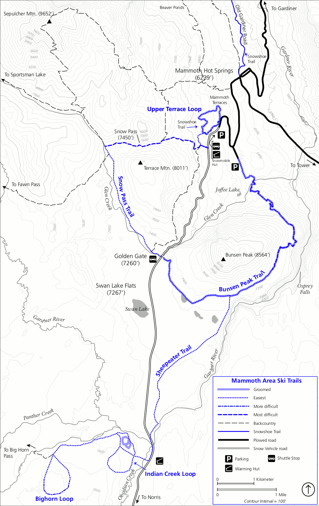 Here is the Mammoth Hot Springs winter trails map, showing the groomed ski trails, snowshoe trails, and roads near Mammoth Terrace and south toward Bunsen Peak, Indian Creek, and Bighorn Loop.
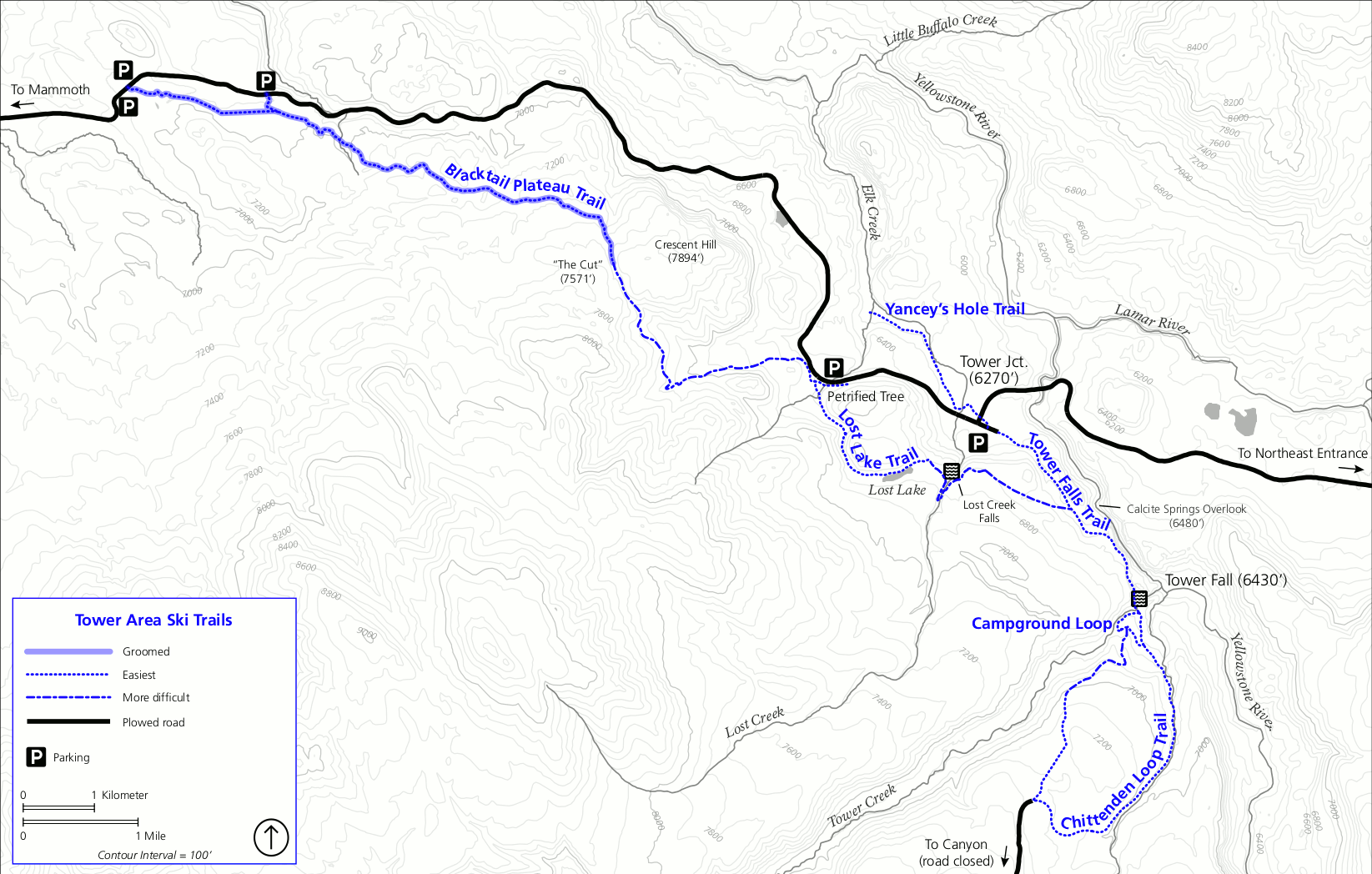 This ski and snowshoe map of the Tower area has the groomed and ungroomed trails near Tower Falls and the Blacktail Plateau. These are located off the plowed all-year highway.
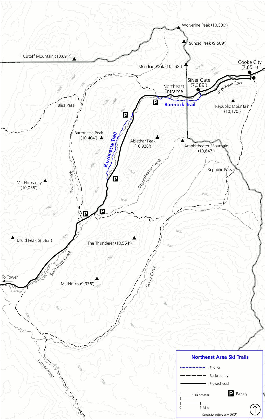 The northeast winter trails map has the Bannock and Barronette ski trails just inside the Northeast Entrance near Cooke City, MT. These trails are also accessible by car.
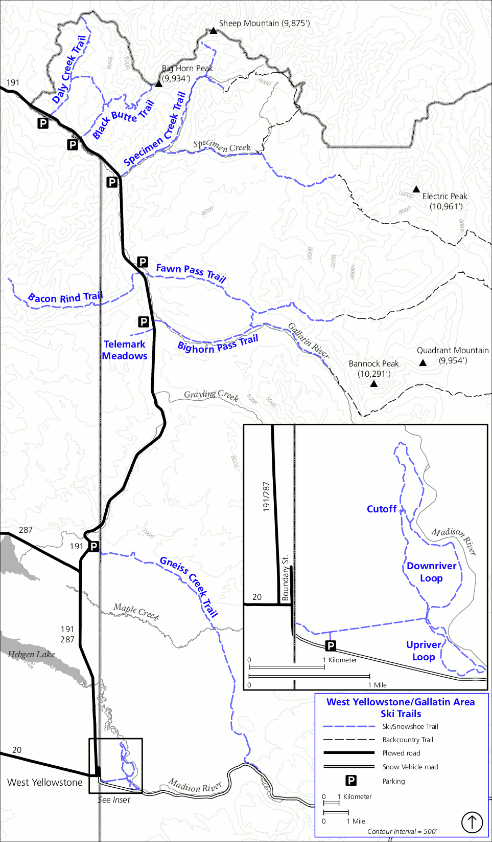 This northwest winter trails map shows ski and snowshoe routes near West Yellowstone and the Gallatin area accessible by road and snowmobile in the extreme northwest corner of Yellowstone.
Yellowstone fishing maps
For each of the four maps in this section, you’ll want the accompanying PDF download of the Yellowstone Fishing regulations (2025 update). This National Park Service guide will help you interpret the rules for each river, lake, and stream.
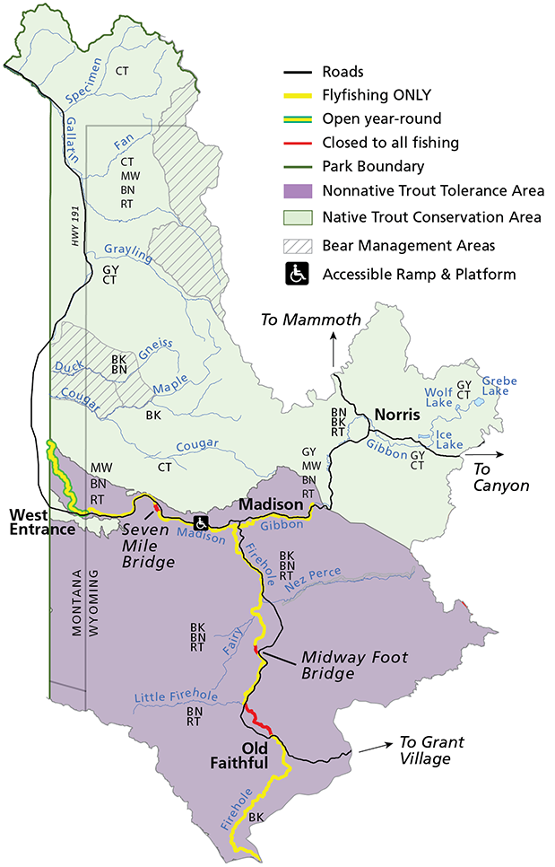 This northwest region fishing map includes a big selection of rivers such as the Madison, Gallatin, Firehole, and Gibbon. Areas include the West Entrance to Old Faithful and Norris and along the western park boundary.
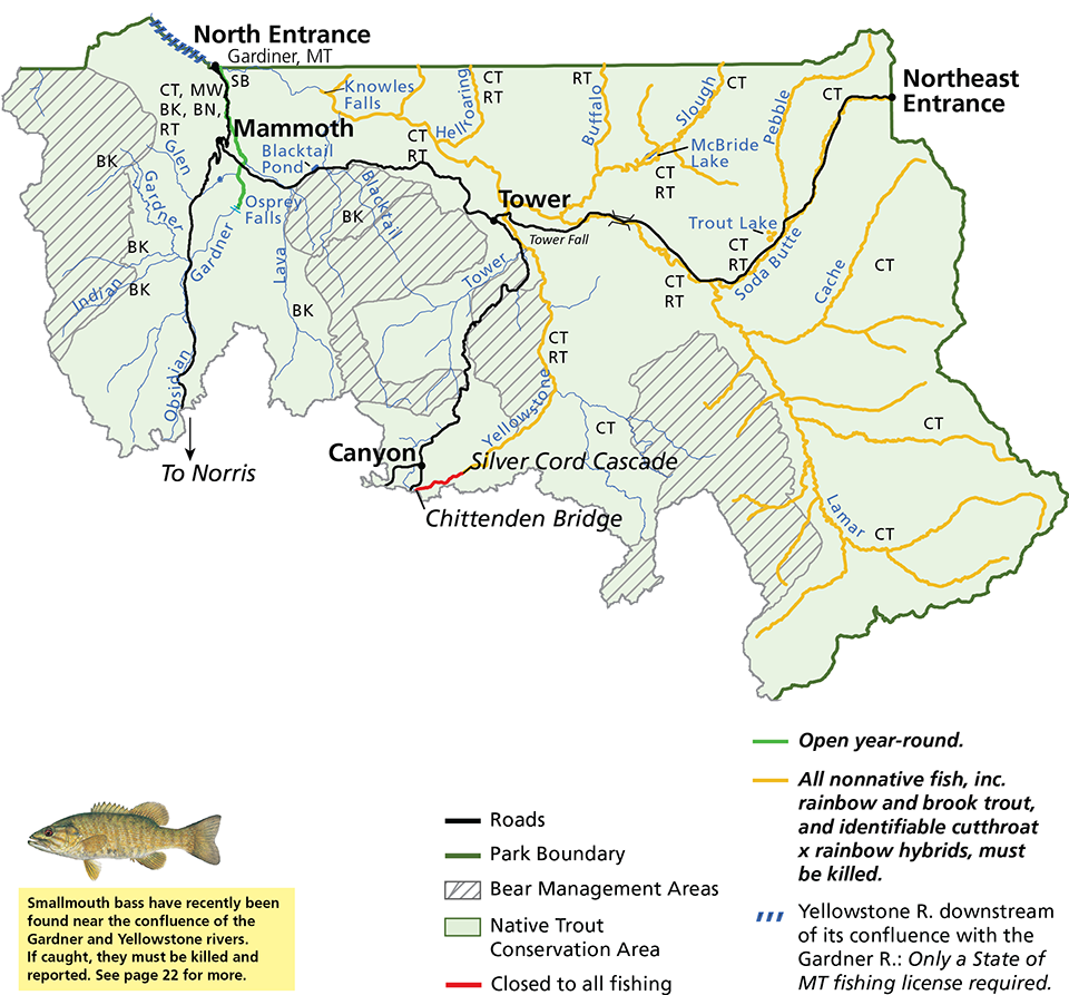 The northeast region fishing map offers the Yellowstone and Lamar rivers. Everything from the North to Northeast Entrance is included, as well as the Canyon area and rivers and streams to the east.
 This is a southwest region fishing map, which involves rivers and streams that are east of the Continental Divide, flowing into the Snake and Lewis rivers. Heart Lake, Lewis Lake, and Shoshone Lake are found in this region.
 The southeast region fishing map is dominated by Yellowstone Lake. Rivers include the Yellowstone and North Fork of the Shoshone. Note that this area has many areas permanently closed to fishing.
Yellowstone topographic maps
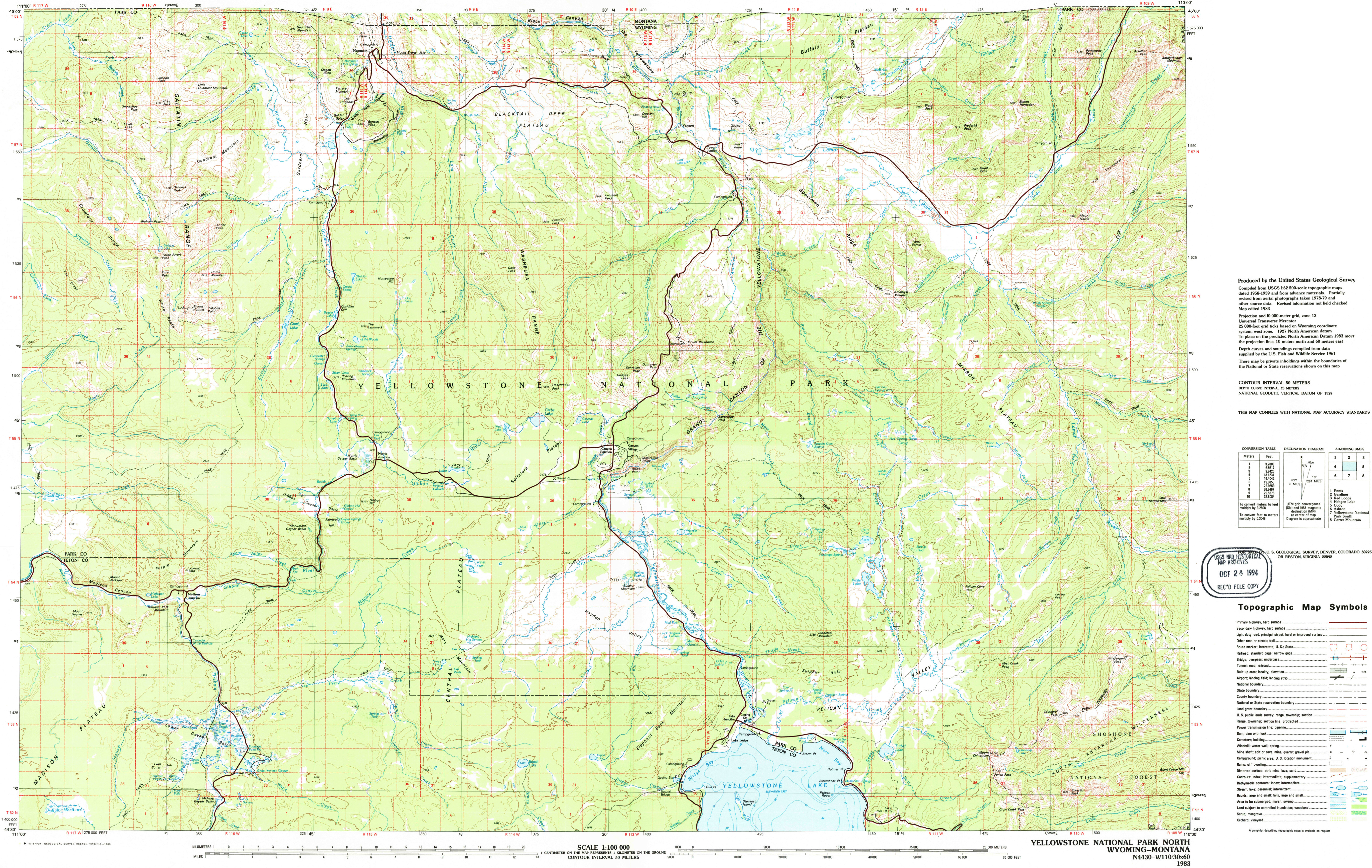 The north Yellowstone topo map focuses on the northern half of the park, extending from Mammoth Hot Springs south past Canyon Village toward Yellowstone Lake, including most popular visitor areas.
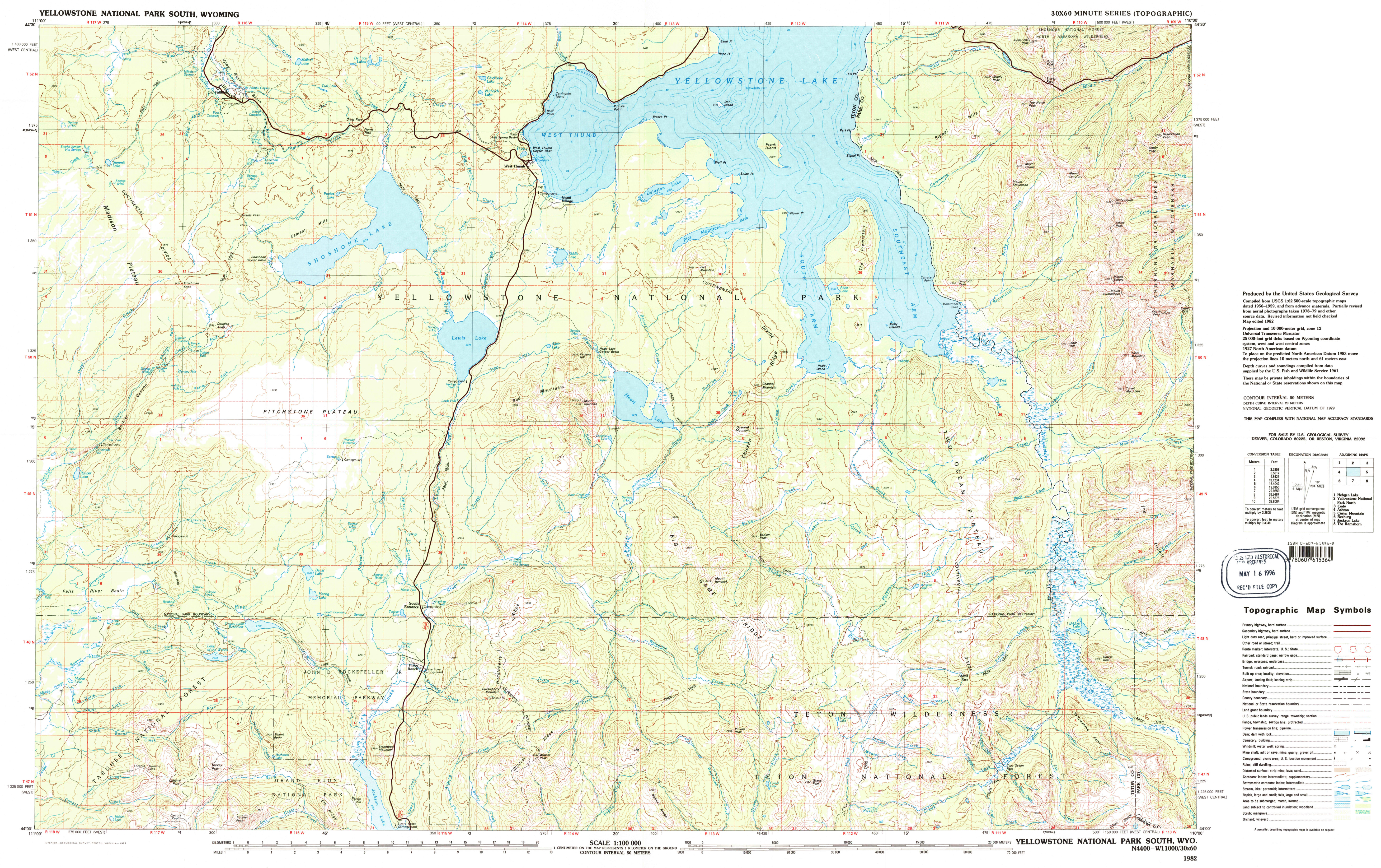 Here’s a south Yellowstone topo map, stretching from Yellowstone Lake south toward the border with Grand Teton National Park – this map features Old Faithful as well as remote parts of Yellowstone.
Printable Yellowstone maps
The following maps cover the same territory as the maps from the official brochure, but the high contrast white background makes them better for printing or viewing on mobile devices in the bright sunlight.
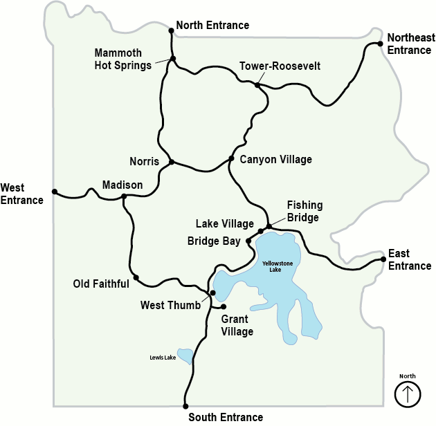
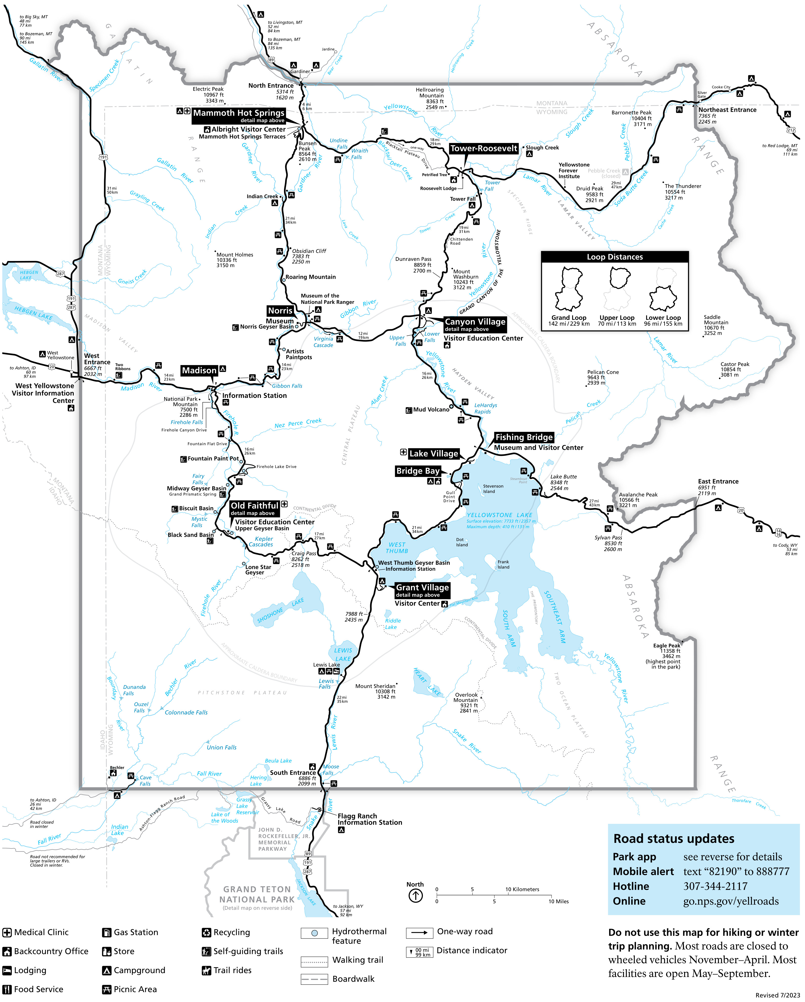 The printable Grand Loop Road map provides a very simple easy-to-read overview of all Yellowstone’s car-accessible areas. A handy inset shows the total mileage for driving the Upper Loop, Lower Loop, or Grand Loop.
 Here’s a printable Old Faithful area map, which zooms in on the Upper Geyser Basin trails and services immediately surrounding Old Faithful. See the locations of the Old Faithful Inn, Snow Lodge, and Old Faithful Lodge.
 This printable Canyon Village map includes both the services near the Grand Canyon of the Yellowstone (lodge, visitor center, cabins, restaurants) and trails and viewpoints like Grand View, Artist Point, and Inspiration Point.
 The printable Mammoth Hot Springs map shows both the trails near the terraces and the services around the Mammoth Hot Springs Hotel. Note the new road alignment to Gardiner in response to the 2023 floods.
 Here’s a printable Grant Village map, showing the concentration of facilities in Grant Village such as the visitor center, campground, lodge, and more. It also includes the West Thumb Geyser Basin just to the north.
 The Lake Village map shows the immediate area surrounding the grand Lake Hotel and Lake Lodge. You’ll also see details of the Bridge Bay area to the southwest and the Fishing Bridge area to the northeast.
 Finally, here’s the full series of Yellowstone maps. It combines every map in this section into a single giant map. The differing scales can make it tricky to read, but having all the maps in a single file download is useful.
Yellowstone science maps
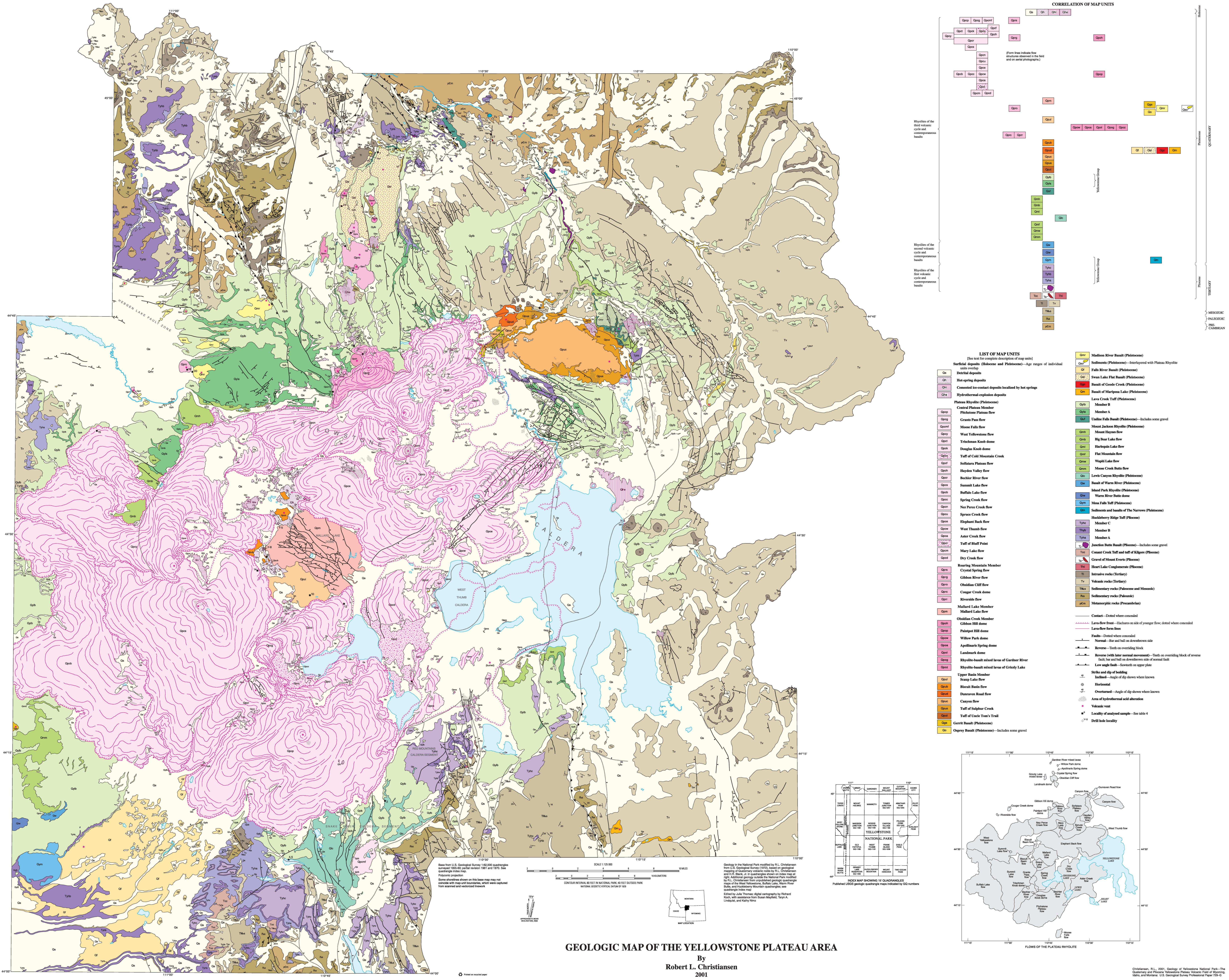 Here’s a Yellowstone geologic map showing the huge variety of volcanic formations and thermal features throughout Yellowstone National Park. The caldera is especially noticeable.
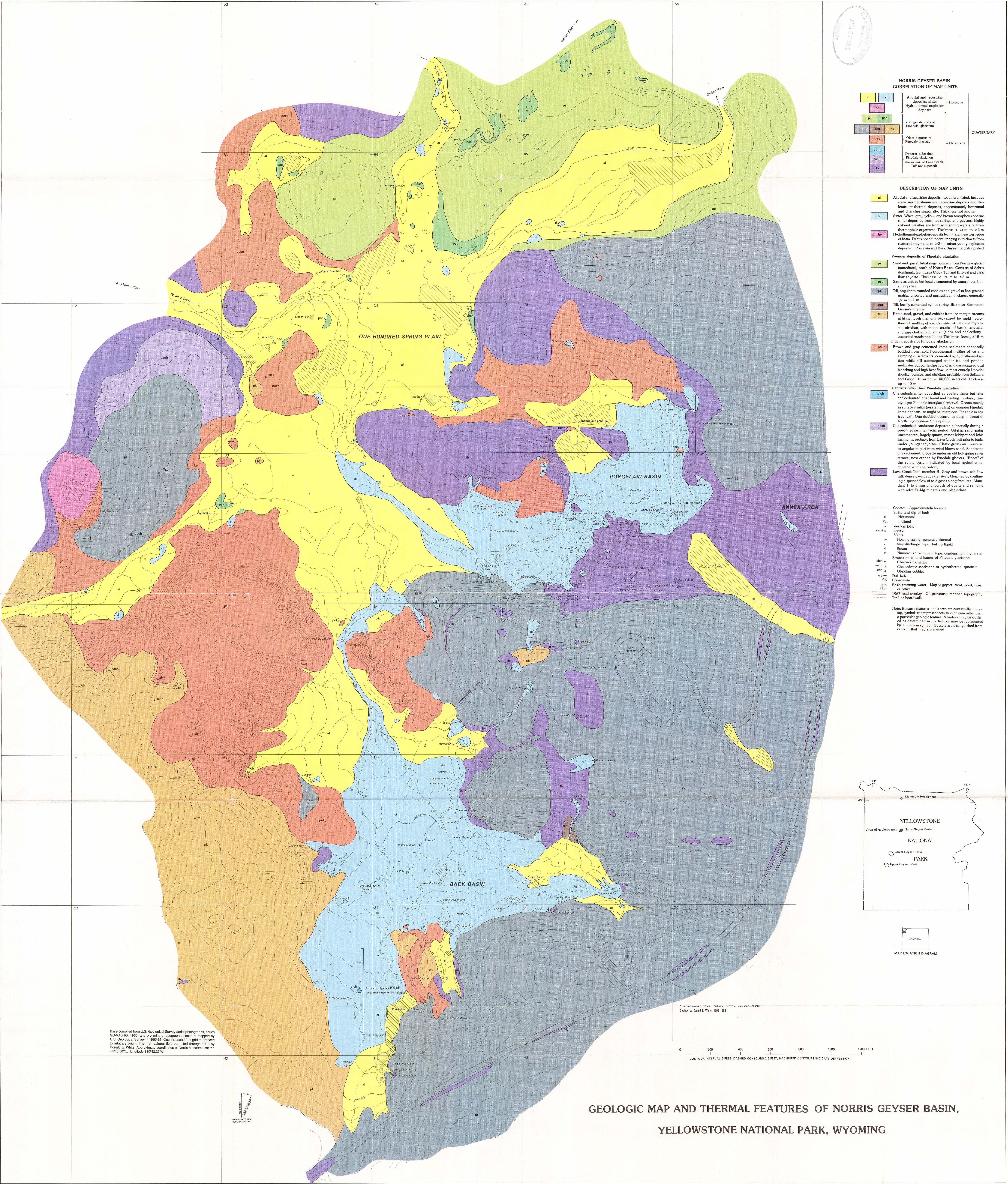 This Norris Geyser Basin geologic map shows the thermal deposits and locations of geysers and hot springs when the map was published in the 1980s—there may be some changes since then!
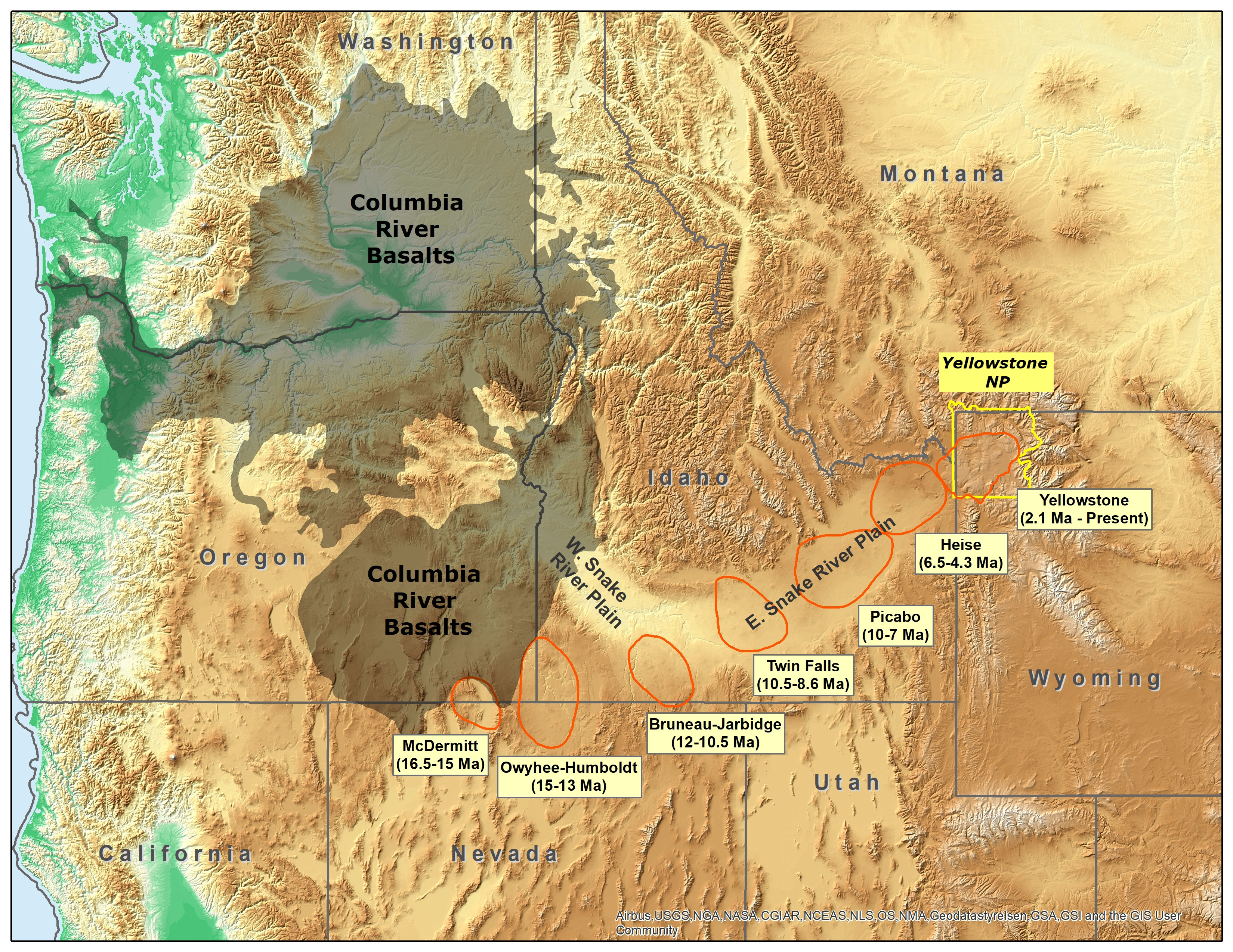 This Yellowstone hotspot map shows how the Yellowstone hotspot has sliced through the mountains to create the eastern Snake River Plain, en route to its present location in northwest Wyoming.
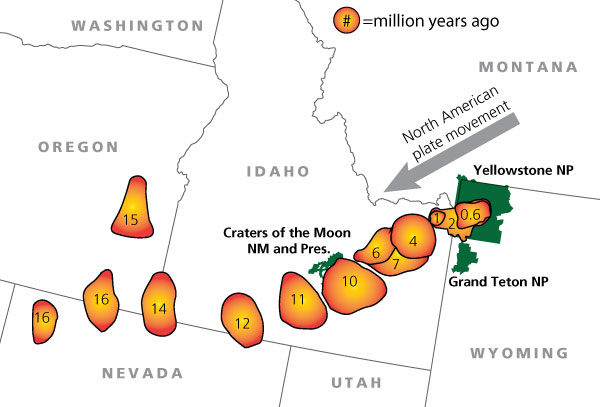 Here’s a simple Yellowstone hotspot map, easier to digest at first glance by stripping away everything but the hotspot locations over time as the North American plate drifted southwest.
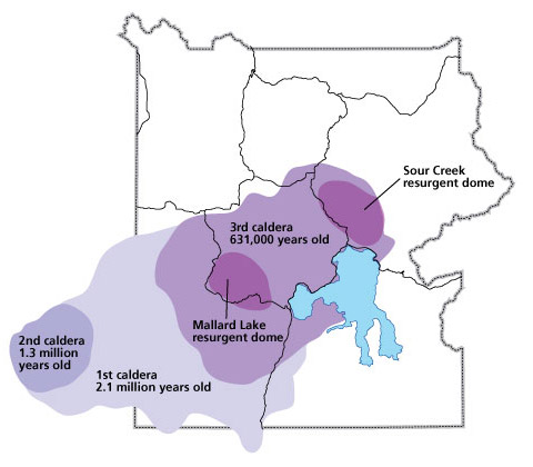 This Yellowstone eruption map plots the nearly incomprehensively large calderas formed from the three most recent Yellowstone eruptions over the last 2.1 million years.
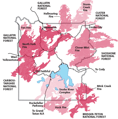 The 1988 Yellowstone fires map plots the full extent of each fire from 1988. Names of each fire are provided. The colors are only to help differentiate fire boundaries and carry no additional significance.
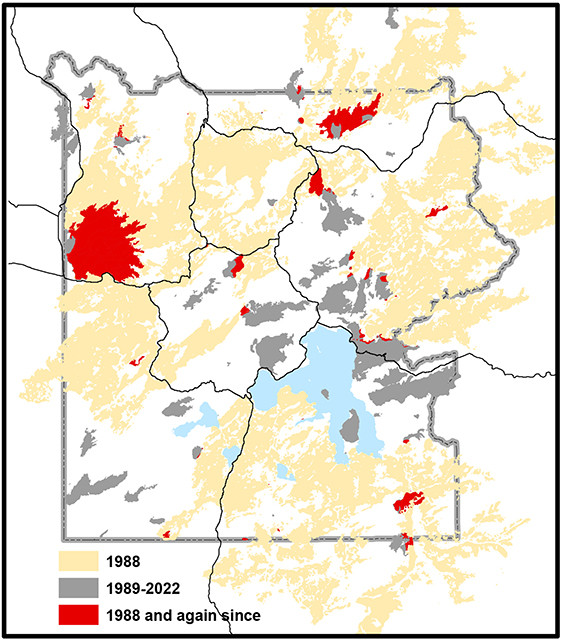 This is a Yellowstone fire map showing fires from 1988 to 2022. Fires from 1989 to 2022 are overlaid against the 1988 fire boundaries, and areas that burned within both periods are indicated.
Yellowstone Lake maps
 The Yellowstone Lake map showcases the lake’s depth and includes geologic layers of the surrounding area. I find this map most useful for its comprehensive labeling of lake shoreline and bottom features.
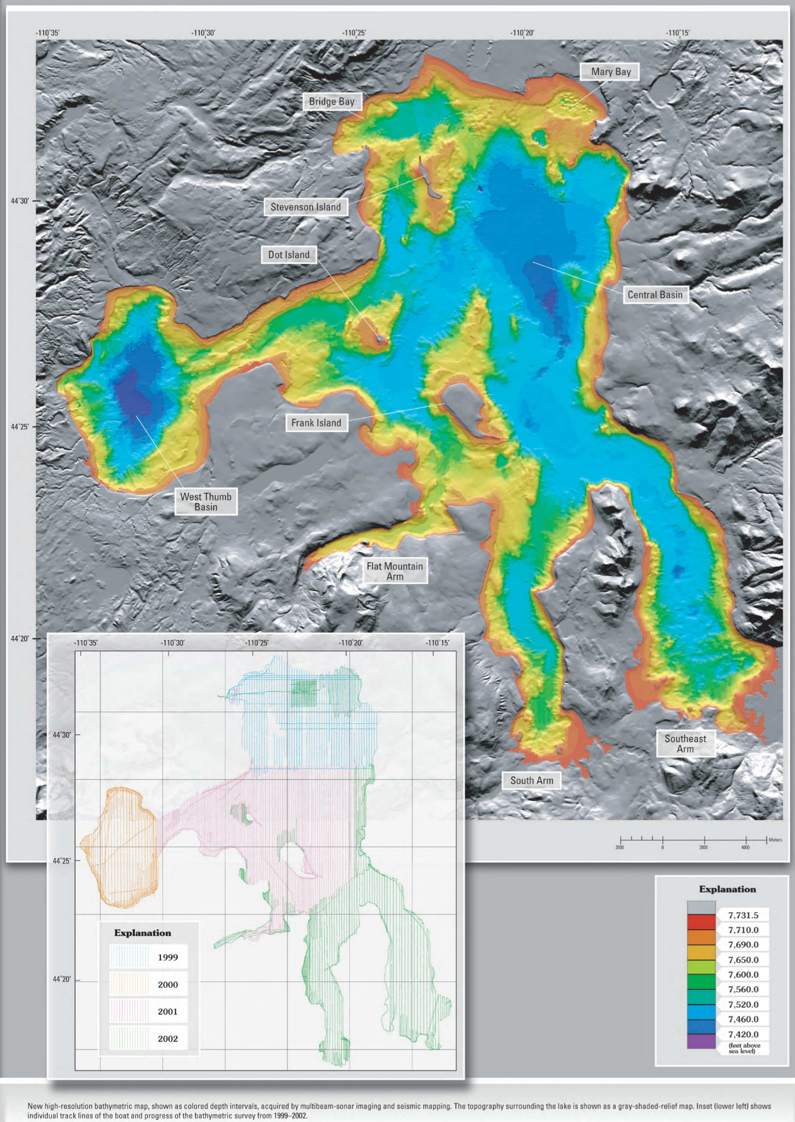 Here’s a Yellowstone Lake depth map showing the varying depths of the lake across its area – note the amazing depth of West Thumb! This is also known as a bathymetric chart.
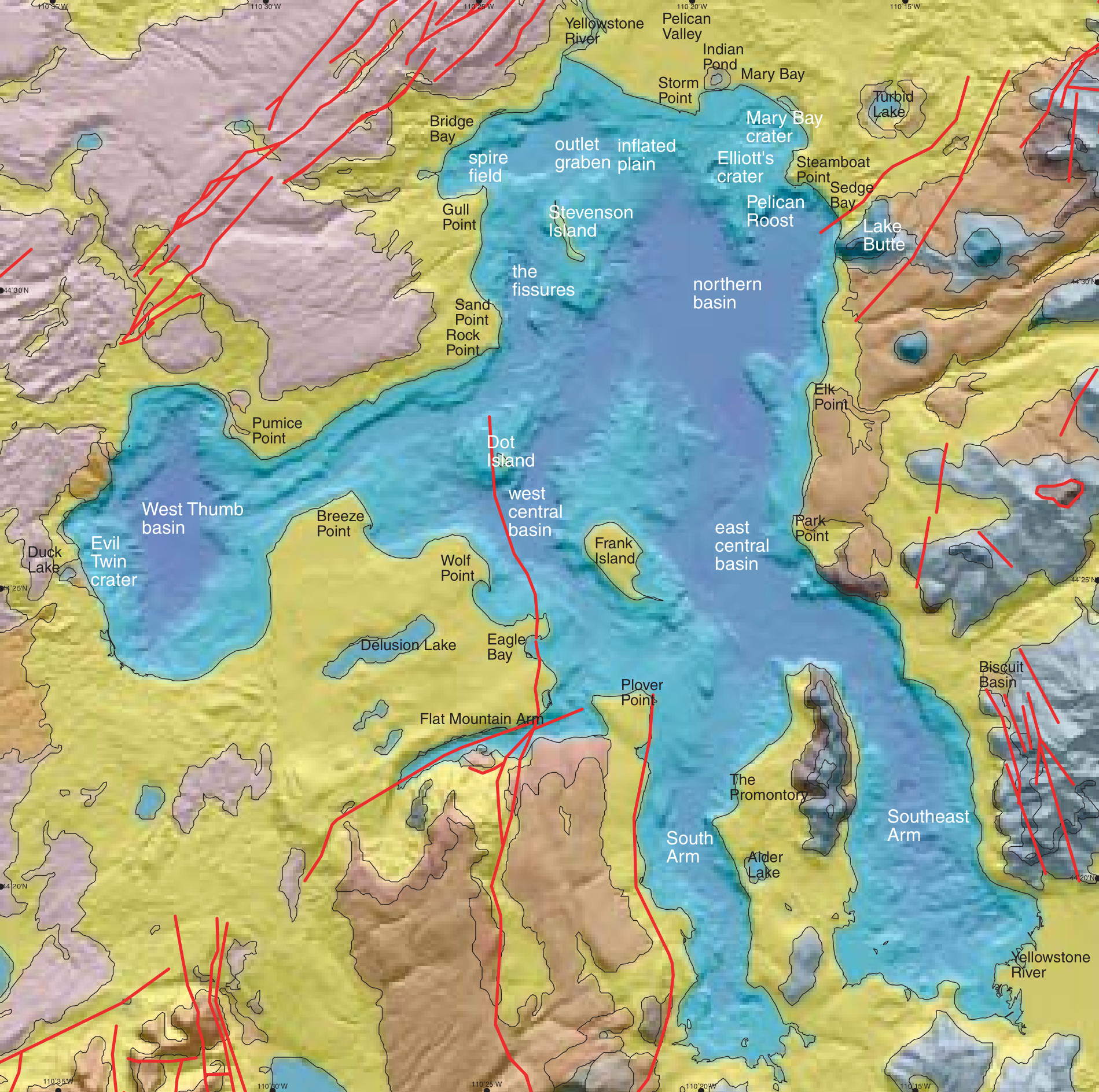
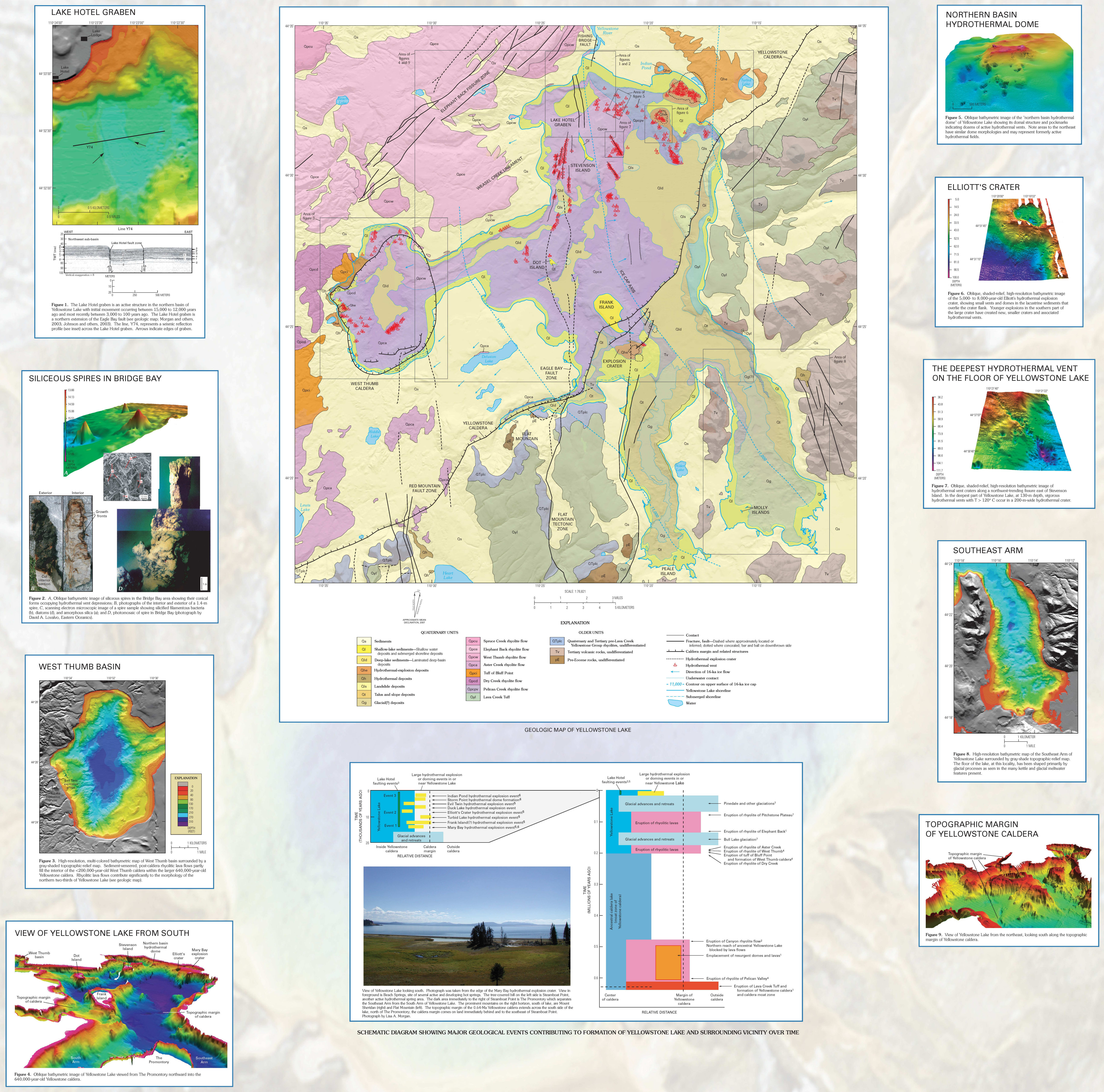 This Yellowstone Lake geologic map shows the rock layers underneath Yellowstone Lake and includes inset maps showing points of geological and topographic interest.
Yellowstone wolf pack maps
 Here’s a 2024 Yellowstone wolf pack map. Click the image to view a full size map showing Yellowstone’s wolf pack ranges that year or download the National Park Service Yellowstone Wolf Project 2024 Annual Report PDF file.
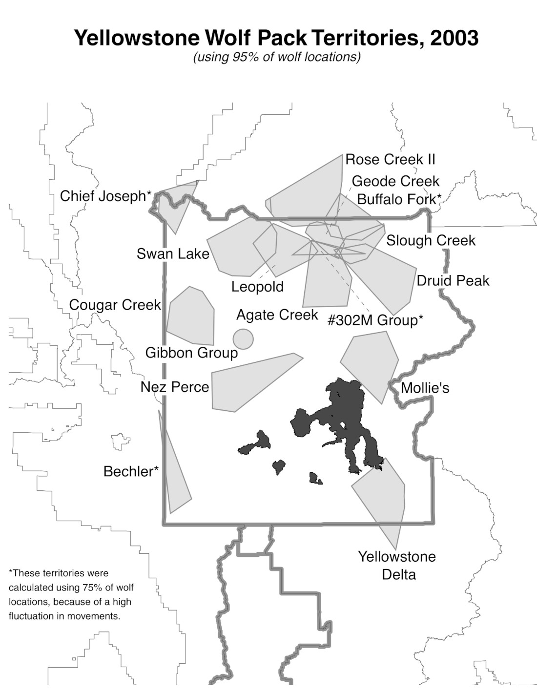
 Here’s a 2023 Yellowstone wolf pack map. Click the image to view a full size map showing Yellowstone’s wolf pack ranges that year or download the National Park Service Yellowstone Wolf Project 2023 Annual Report PDF file.
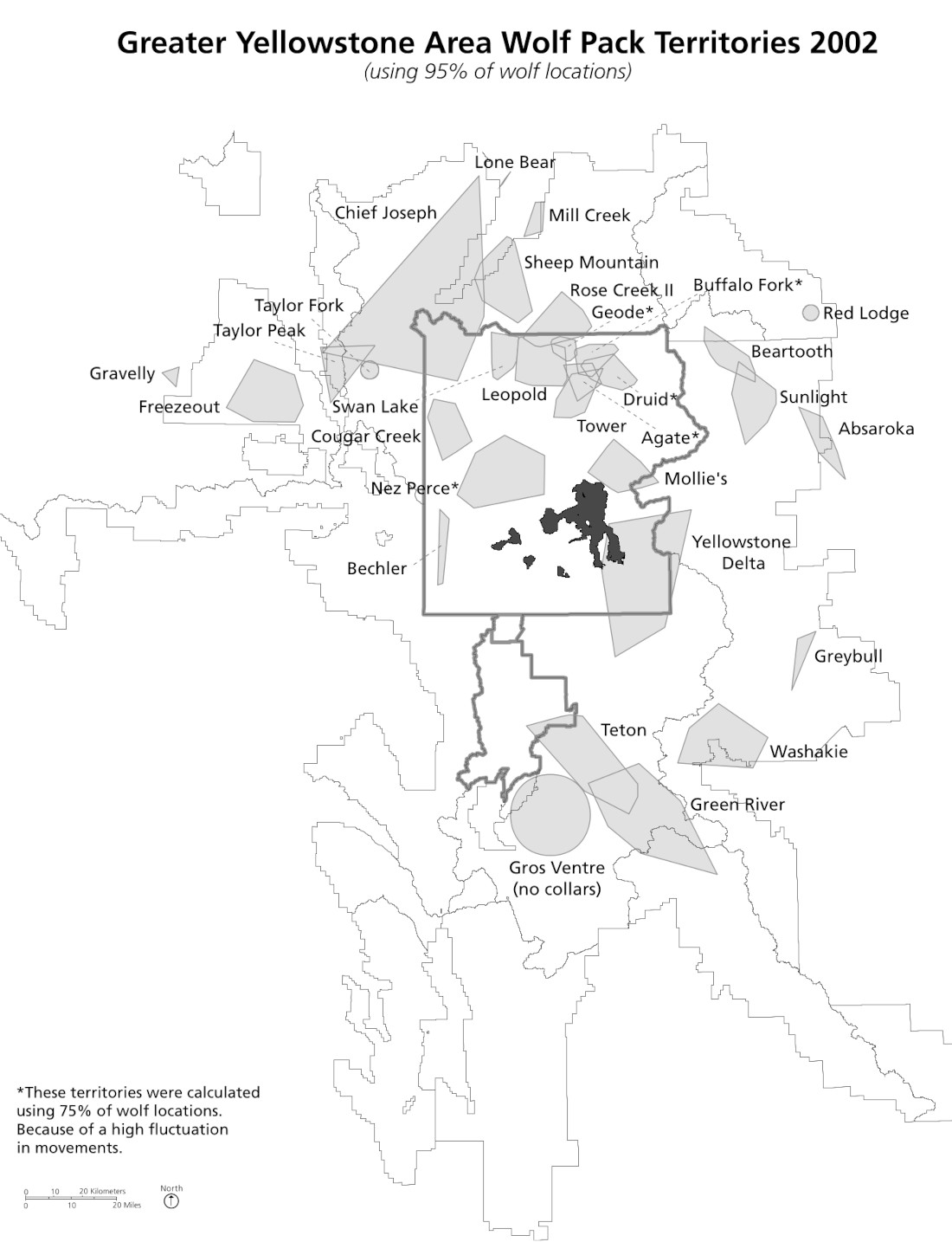
 Here’s a 2022 Yellowstone wolf pack map. Click the image to view a full size map showing Yellowstone’s wolf pack ranges that year or download the National Park Service Yellowstone Wolf Project 2022 Annual Report PDF file.
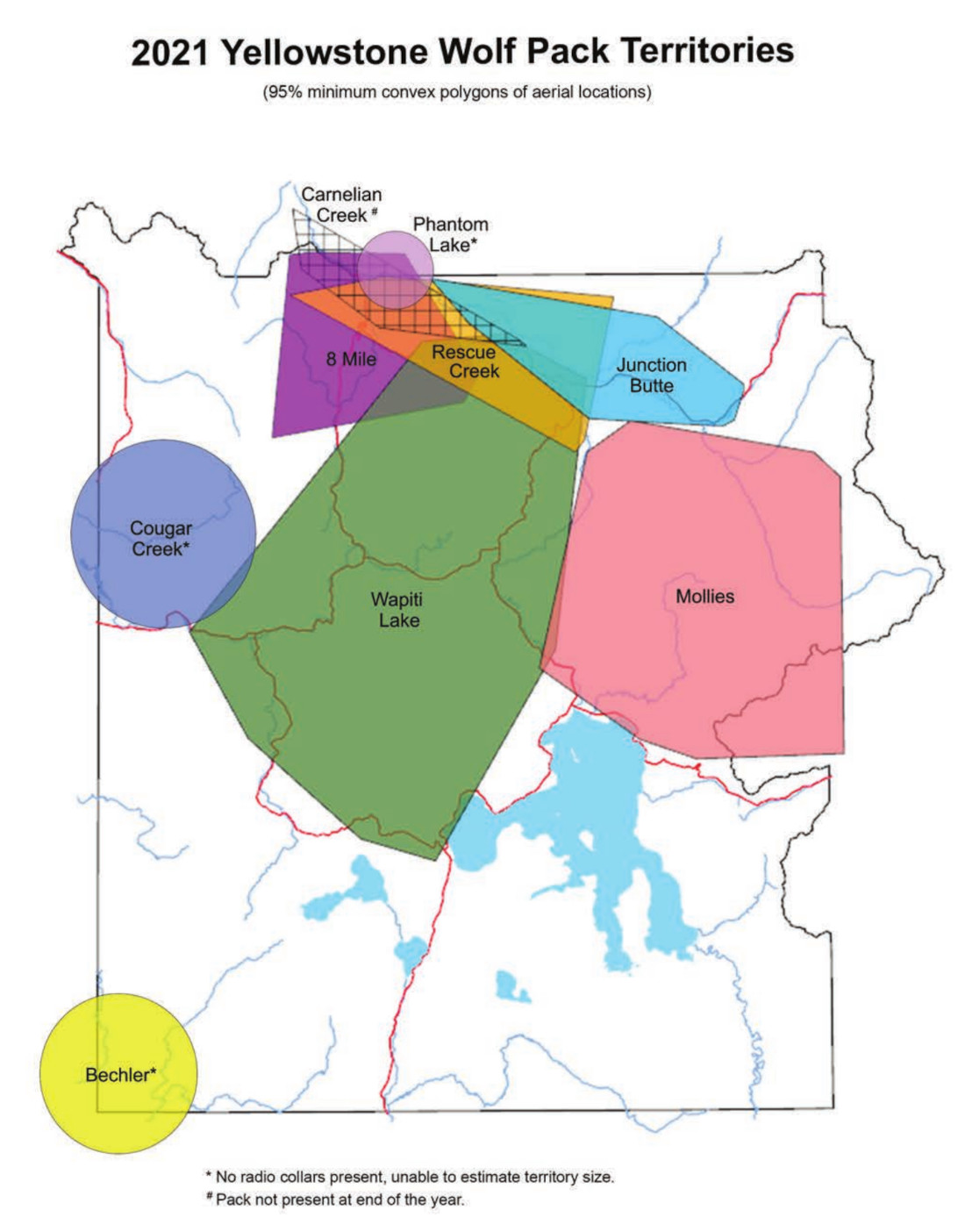 Here’s a 2021 Yellowstone wolf pack map. Click the image to view a full size map showing Yellowstone’s wolf pack ranges that year or download the National Park Service Yellowstone Wolf Project 2021 Annual Report PDF file.
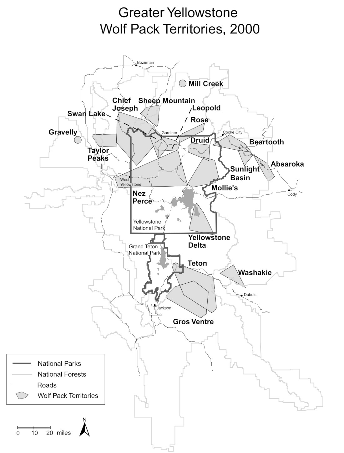
 Here’s a 2020 Yellowstone wolf pack map. Click the image to view a full size map showing Yellowstone’s wolf pack ranges that year or download the National Park Service Yellowstone Wolf Project 2020 Annual Report PDF file.
 Here’s a 2019 Yellowstone wolf pack map. Click the image to view a full size map showing Yellowstone’s wolf pack ranges that year or download the National Park Service Yellowstone Wolf Project 2019 Annual Report PDF file.
 Here’s a 2018 Yellowstone wolf pack map. Click the image to view a full size map showing Yellowstone’s wolf pack ranges that year or download the National Park Service Yellowstone Wolf Project 2018 Annual Report PDF file.
Below you’ll find Yellowstone wolf pack map files and PDF downloads of Yellowstone Wolf Project annual reports prior to 2018. Wolf report PDF links will open in a new window.
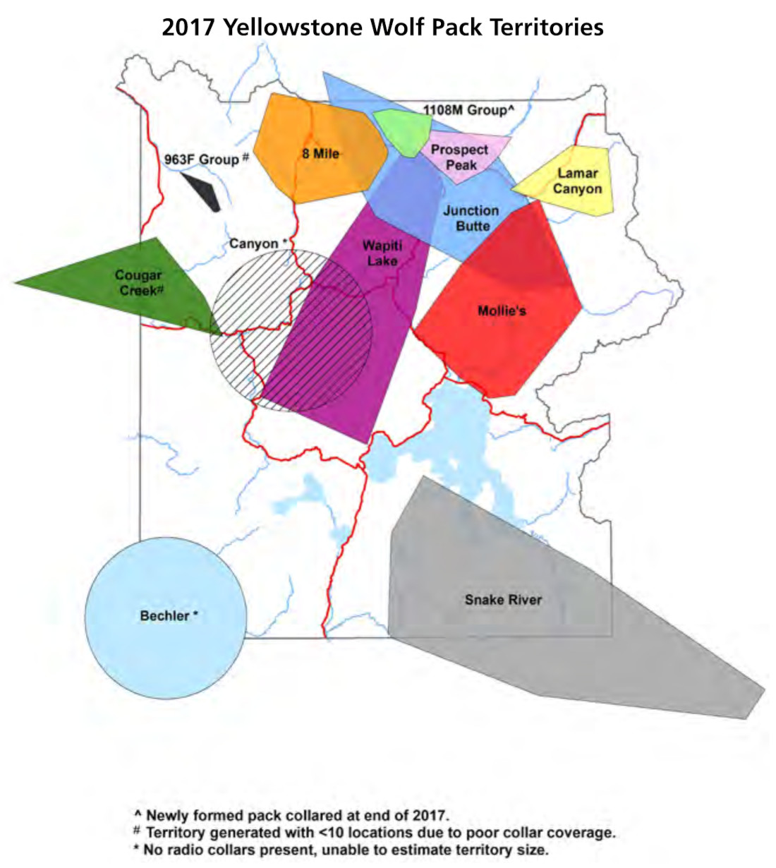
- 2017 wolf map | 2017 wolf report
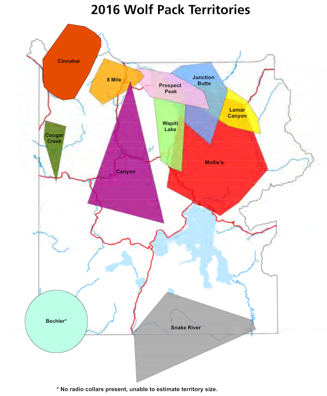
- 2016 wolf map | 2016 wolf report
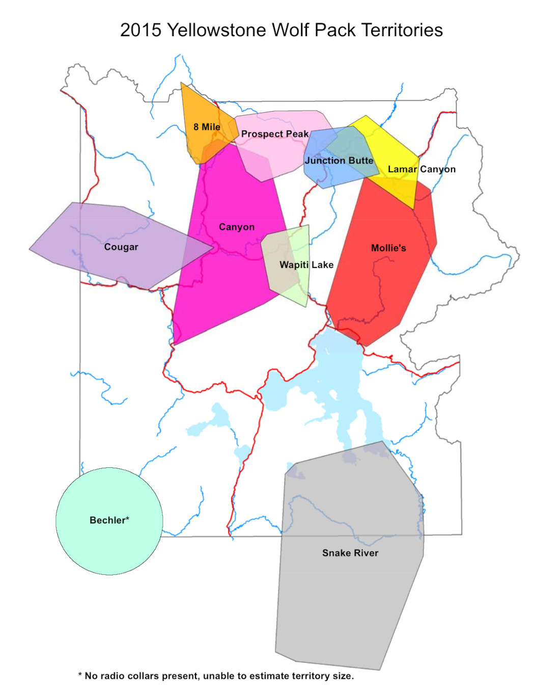
- 2015 wolf map | 2015 wolf report
- 2014 wolf map | 2014 wolf report
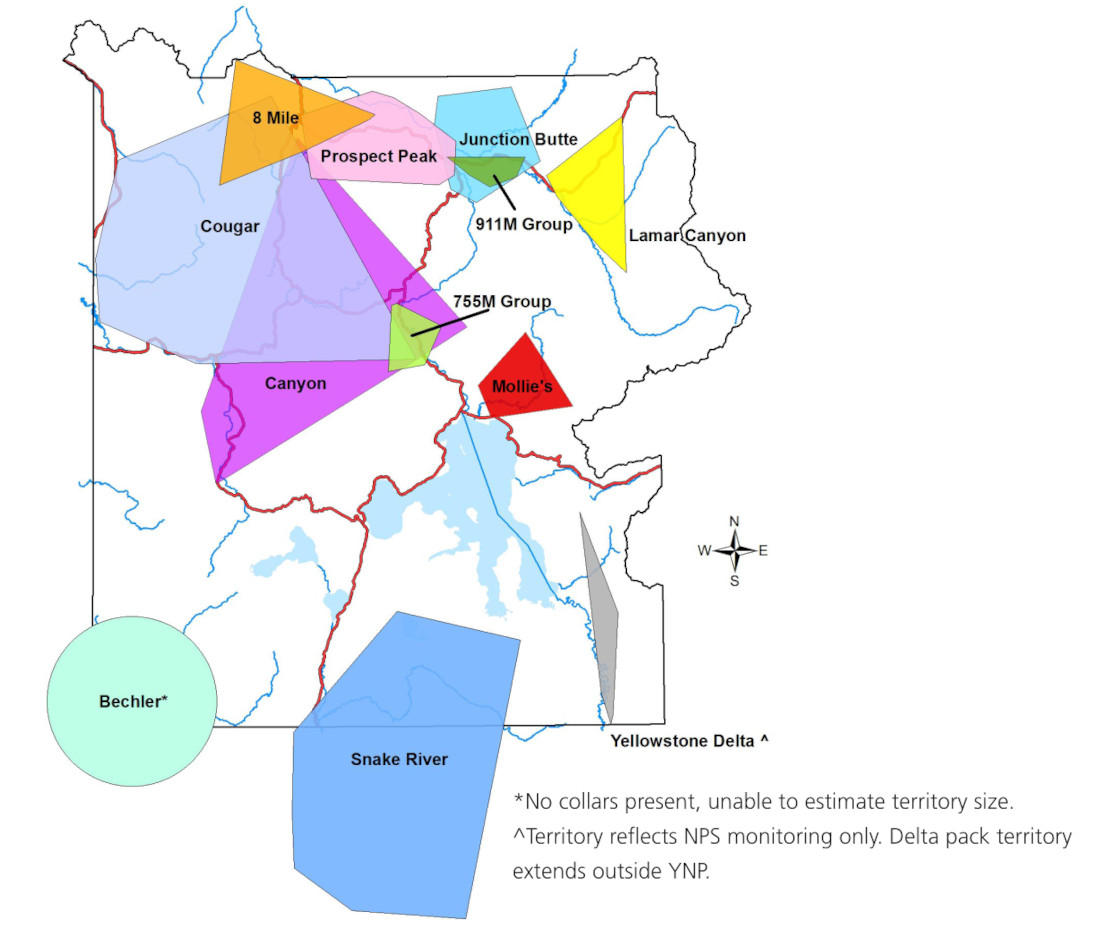
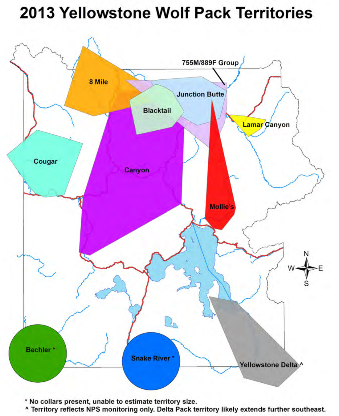
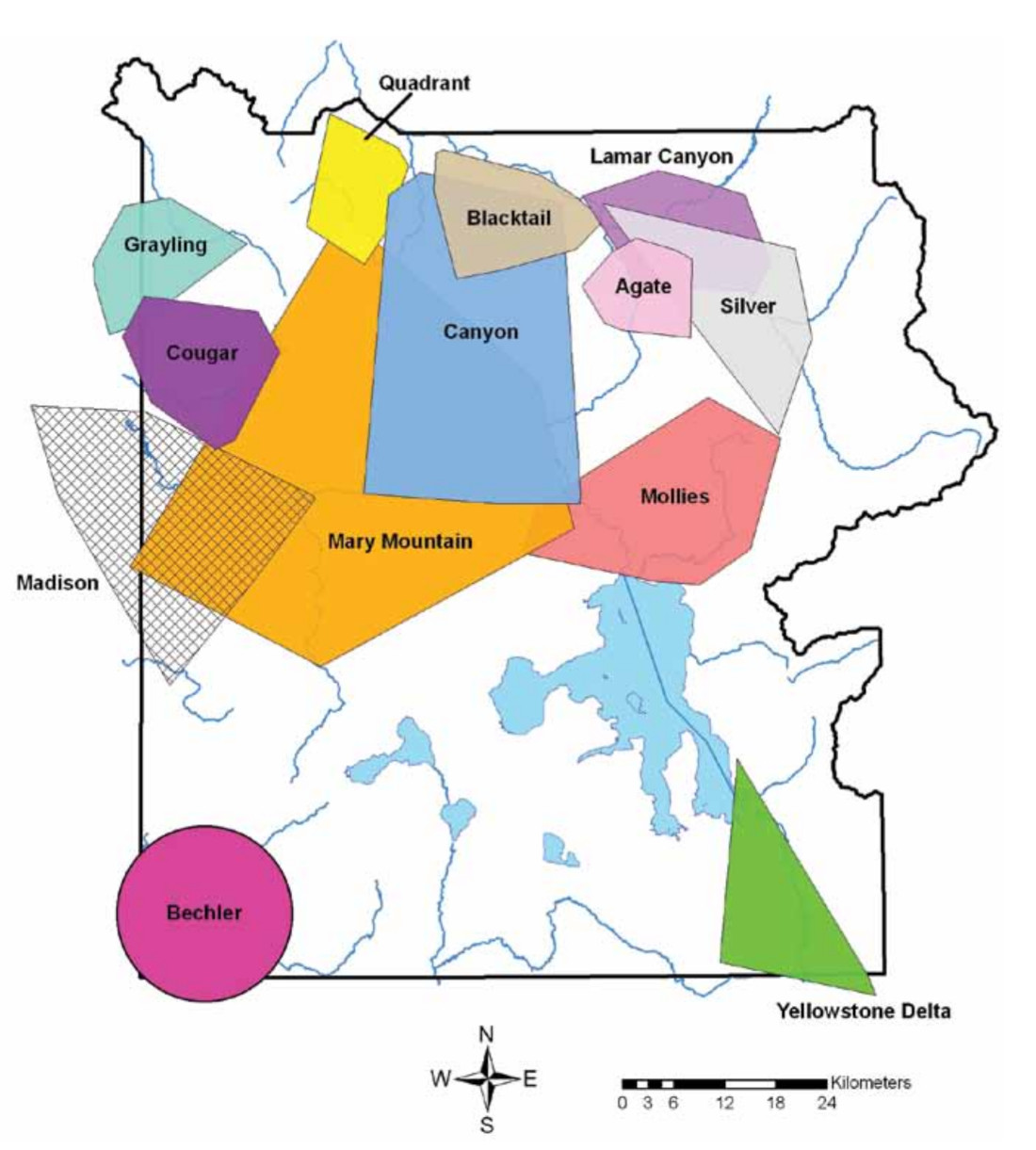
- 2013 wolf map | 2013 wolf report
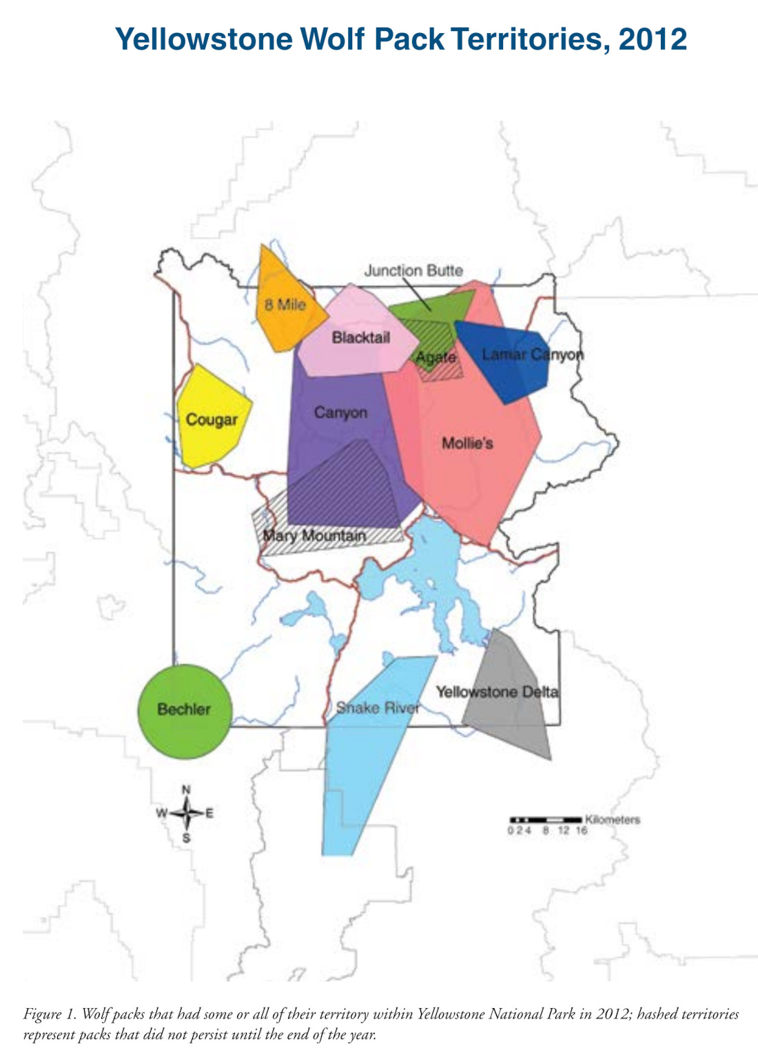
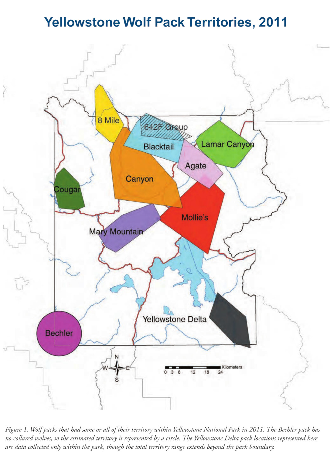
- 2012 wolf map | 2012 wolf report
- 2011 wolf map | 2011 wolf report
- 2010 wolf map | 2010 wolf report
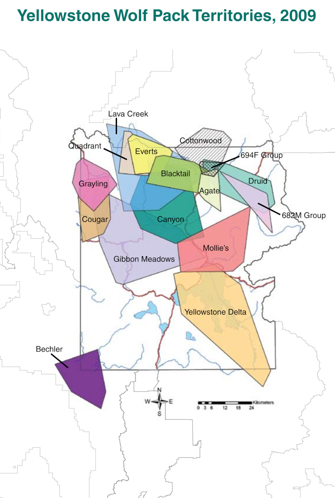
- 2009 wolf map | 2009 wolf report
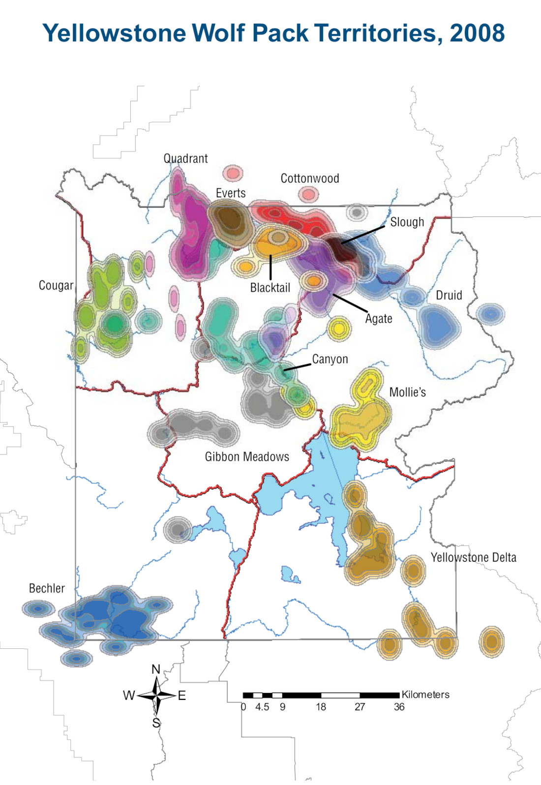
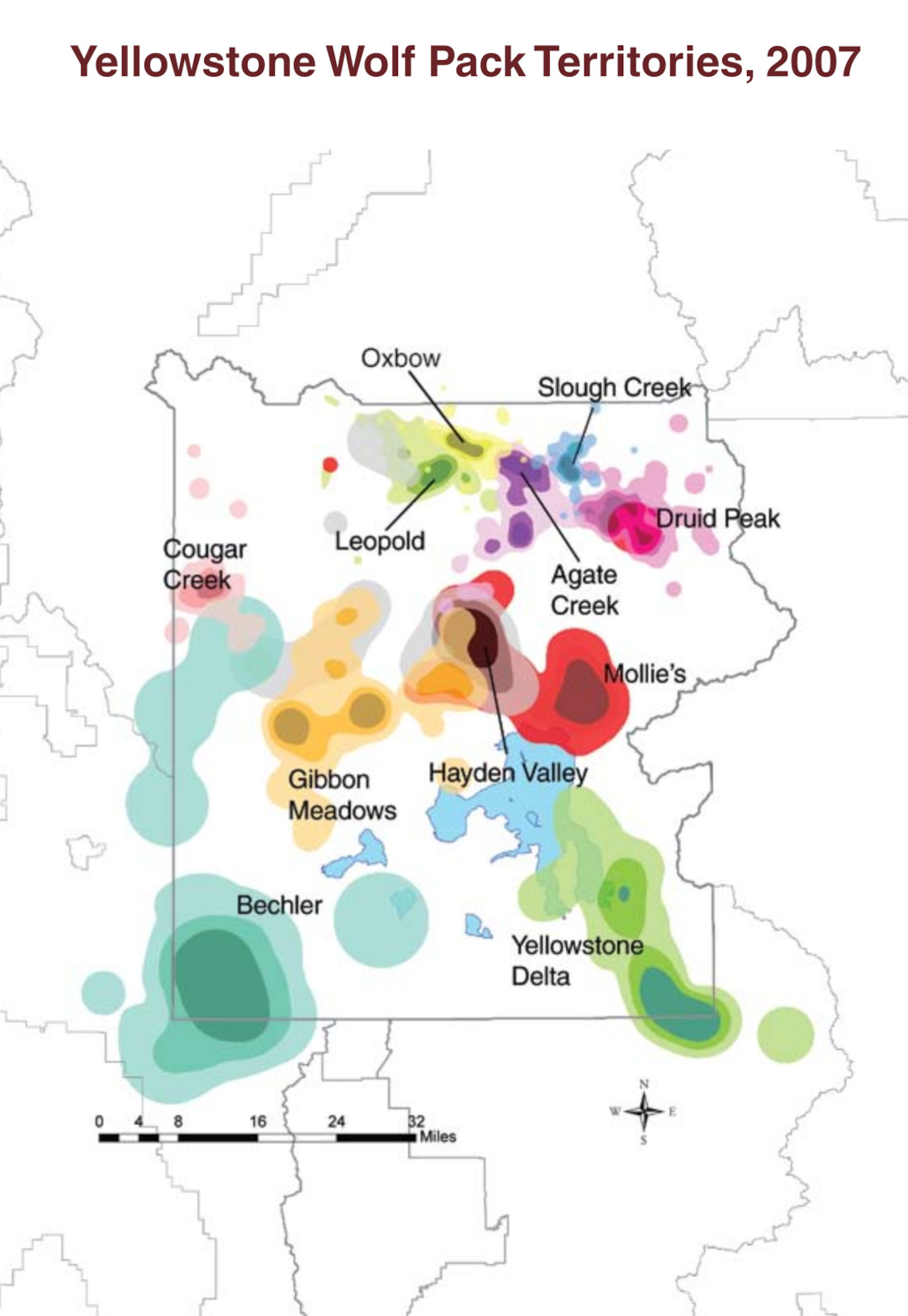
- 2008 wolf map | 2008 wolf report
- 2007 wolf map | 2007 wolf report
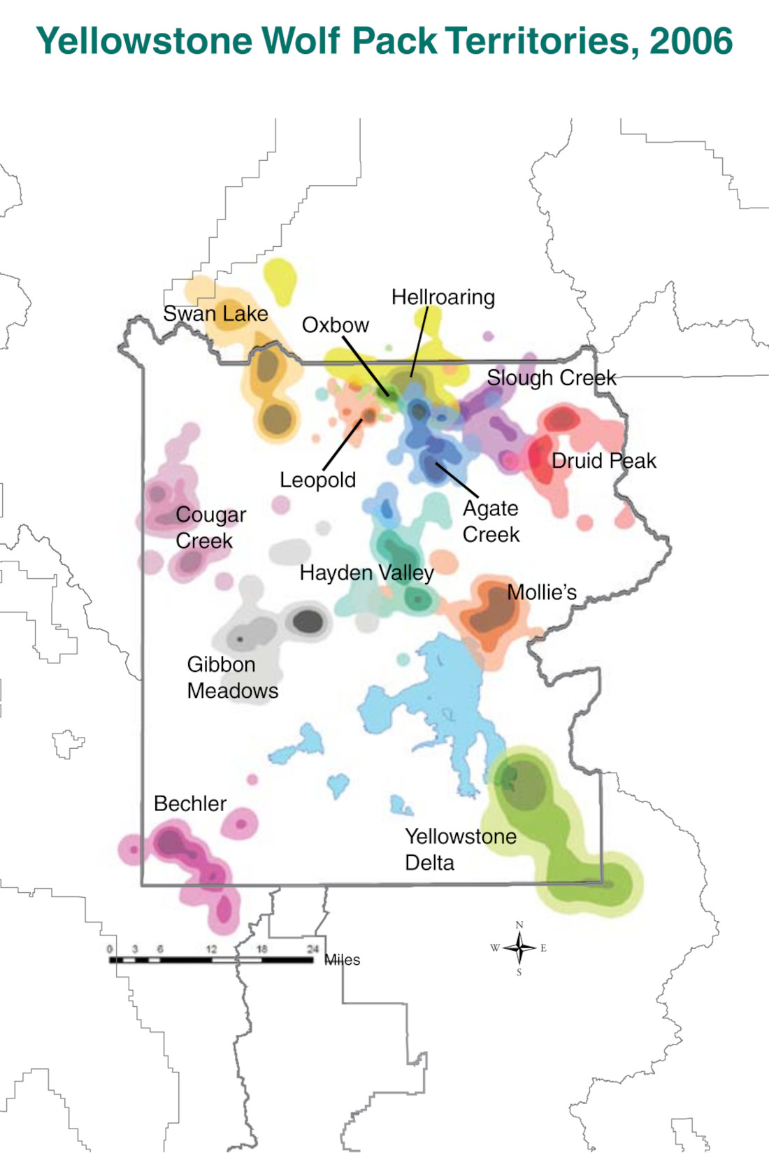
- 2006 wolf map | 2006 wolf report
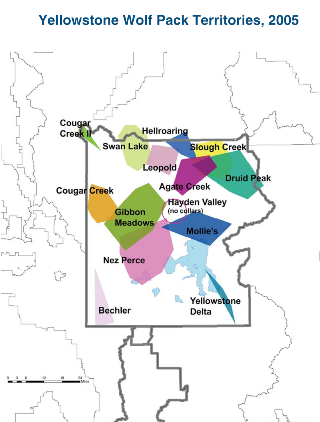
- 2005 wolf map | 2005 wolf report
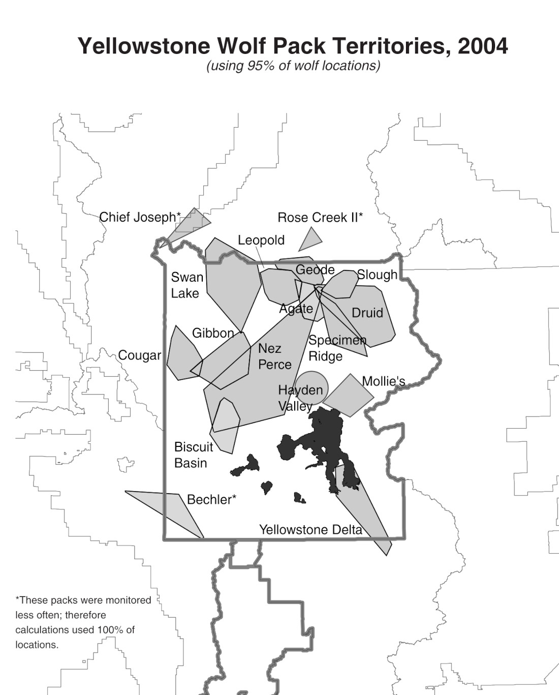
- 2004 wolf map | 2004 wolf report
- 2003 wolf map | 2003 wolf report
- 2002 wolf map | 2002 wolf report
- 2001 wolf map | 2001 wolf report
- 2000 wolf map | 2000 wolf report
- 1999 wolf map | 1999 wolf report
- 1998 wolf map | 1998 wolf report
- 1997 wolf map | 1997 wolf report
- 1996 wolf map | 1996 wolf report
Assorted Yellowstone maps
 The Yellowstone bike map color codes the various park roads on the upper and lower loops by when biking is permitted. In the north, you can bike all year, but other roads are only when they’re seasonally closed to vehicles.
 This Yellowstone attractions map overlays features like Grand Prismatic Spring, Old Faithful, Lamar Valley, Hayden Valley, and Obsidian Cliff over a simplified park map, for an attractive presentation.
 Here’s a Yellowstone cell service map that shows what areas of the park you can expect to receive service for your cellular phone as of 2019. (Generally Verizon’s coverage is most extensive.)
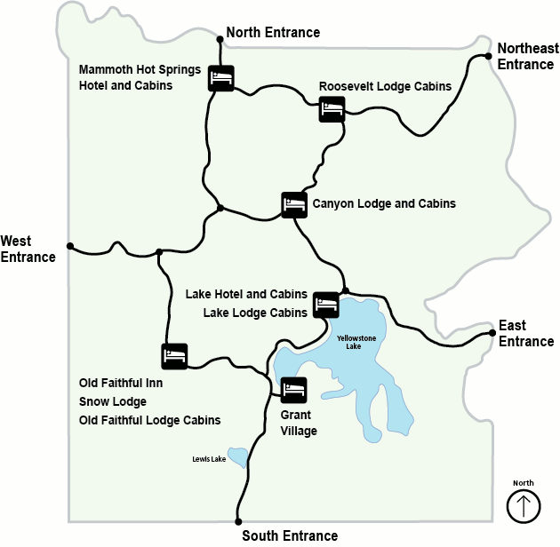
 The simple Yellowstone map is a printable easy-to-read map that just shows the basic layout of Yellowstone’s points of interest with no extra detail. It’s best for when you just want the basics.
 This is a Yellowstone lodging map. This map has the same base layer as the previous one, but of lodging facilities marked rather than points of interest, making it easy to compare your lodging options.
Archived Yellowstone maps
The National Park Service is constantly publishing new maps and updating old ones. I strive to update this webpage with new maps as they become available, but I never delete old maps; I feel it’s important to preserve the story of how parks change over time. Maps below are no longer the most recent version, but they’re shared here for archival purposes.
 This was the main Yellowstone National Park map before 2023, showing roads, attractions, lodging, campgrounds, and points of interest throughout Yellowstone. Click the image to view a full size map.
 This is the late-2010s Old Faithful map showing trails, lodging, and services in the Old Faithful geyser area. Venture beyond Old Faithful! The other geysers and pools are incredible and you can get much closer.
 This is the late-2010s Mammoth Hot Springs map showing roads, trails, lodging, camping, and attractions around Mammoth Hot Springs, including both the Upper and Lower Terraces.
 This is the late-2010s Canyon Village map showing Canyon Lodge, the campground, hiking trails, and the amazing iconic viewpoints including Artist Point, Inspiration Point, Grand View, and Lookout Point.
 This is the late-2010s West Thumb and Grant Village map showing West Thumb Geyser Basin, Grant Village, and the surrounding roads, trails, campground, lodge, and services at the west end of Yellowstone Lake.
 This is the late-2010s Lake Village and Fishing Bridge map showing Bridge Bay, Lake Village, the Lake Hotel, Fishing Bridge, and the surrounding roads, trails, and campgrounds, and lodging on Yellowstone Lake.
 This 2013 Yellowstone brochure map, saved here for archival purposes, has since been superseded by the one on top of this page. Click the image to view a full size map or download the PDF.
 This old printable Yellowstone map from the mid-2010s shows the entire national park, including roads, picnic areas, campgrounds, and points of interest. It includes driving distances and time estimates as well.
 This old printable Old Faithful map from the mid-2010s focuses on the Upper Geyser Basin and developed areas immediately surrounding Old Faithful Geyser out to Castle Geyser and Grand Geyser.
 Here’s an old printable Mammoth Hot Springs map from the mid-2010s, showing the Upper and Lower Terraces and also the village area including the visitor center, Mammoth Hot Springs Hotel, and visitor services.
 This old printable Canyon Village map from the mid-2010s includes the area around the Canyon Lodge and visitor center as well as the rim drives to the various Grand Canyon of the Yellowstone viewpoints.
 This old printable West Thumb and Grant Village map from the mid-2010s shows the many visitor facilities in Grant Village and the nearby West Thumb Geyser Basin – visitor center, lodge, campground, and so on.
 Here’s an old printable Lake Village and Fishing Bridge map from the mid-2010s, which also includes Bridge Bay and shows the Lake Hotel, Lake Lodge, marina, campgrounds, and services such as laundry and showers.
…and more!
< Return to National Park Maps home
< Return to Park List
< Return to List by State