 The first iteration of the pages for Redwood, Zion, and Yellowstone national parks is completed. I haven’t come across too much for Redwood yet, but I’m optimistic I’ll find more. At this point I’m only uploading maps that I know are public domain; later I’ll send out emails asking for permission to post other relevant maps that may not be non-public domain, such as California State Park maps in the Redwoods.
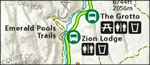 I’m happier with my start on Yellowstone and Zion. I was able to get a decent number of maps just from digging through the park websites and the Harpers Ferry map library. I’ve improved upon Zion’s website, even; both the wilderness campsite map and the hiking maps were separate pages in PDF files. By merging them into single maps, I’ve made these maps much easier to use. I will continue to look for opportunities to create better maps than on the Park Service websites.

I’ve also gone back to some of the first pages I created and have reduced the sizes of some of the JPG files a bit. I’ve been generating the JPGs from PDF files, and some of them I created at a needlessly high resolution, which was a bit overkill. So I’m in the process of shrinking them down a tiny bit, so they’re large enough to be easily readable but not an unnecessarily large file size.
 Next up: reducing some more map file sizes, as well as adding in external links on Yellowstone, Zion, and Redwood for the maps I don’t have, such as detailed trail maps and topo maps. I’m struggling a bit between using my time to just start getting tons of pages up, versus getting every page as complete as possible before moving on to the next. I guess it’s fine whatever I end up doing, since either way it’s progress. It does feel good to have 10 parks up for now, after all!