This page currently offers 5 free Gateway Arch National Park maps for you to view or download: NPS brochure maps, parking maps, and more. In addition to the free Gateway Arch maps, I include external affiliate links that help cover my costs and allow me to keep this site ad-free. These links have shaded backgrounds (like this example) so you can easily recognize or skip past them: Browse the best-selling Gateway Arch maps and books on Amazon.
Gateway Arch brochure map
 This is the official NPS Gateway Arch National Park map, showing the underground visitor center and other site facilities, including the Old Courthouse. Click the image to view a full size map or download the PDF.
Other Gateway Arch maps
 Here’s a Gateway Arch parking map from 2025, showing convenient parking locations as well as passenger drop-off/pick-up zones and public transportation access through St. Louis MetroLink.
 This Gateway Arch landscape map color codes the park grounds to show what grows where: turf grass, native grass, and bald cypress trees. It also shows the location of the zen gardens and Explorers’ Garden.
Gateway Arch lodging map
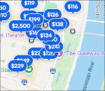 Obviously if you want to stay near the Gateway Arch, you’ll be in St. Louis. To the right, you can open an Expedia interactive St. Louis lodging map where I’ve focused the map on the Arch and showed the hotels closest to it. Many of them are only a couple blocks away. You may also want to browse Expedia’s top-rated St. Louis lodging (again, focused on proximity to the Arch) where you can compare location, prices, amenities, and photos.
…and more!
< Return to National Park Maps home
< Return to Park List
< Return to List by State
Need more help? Browse Amazon’s best-selling Gateway Arch maps and guidebooks.