Note: Due to impacts from the 2025 Dragon Bravo fire, North Rim maps on this page are no longer current. Updated maps will be provided when available.
Grand Canyon map from the park brochure
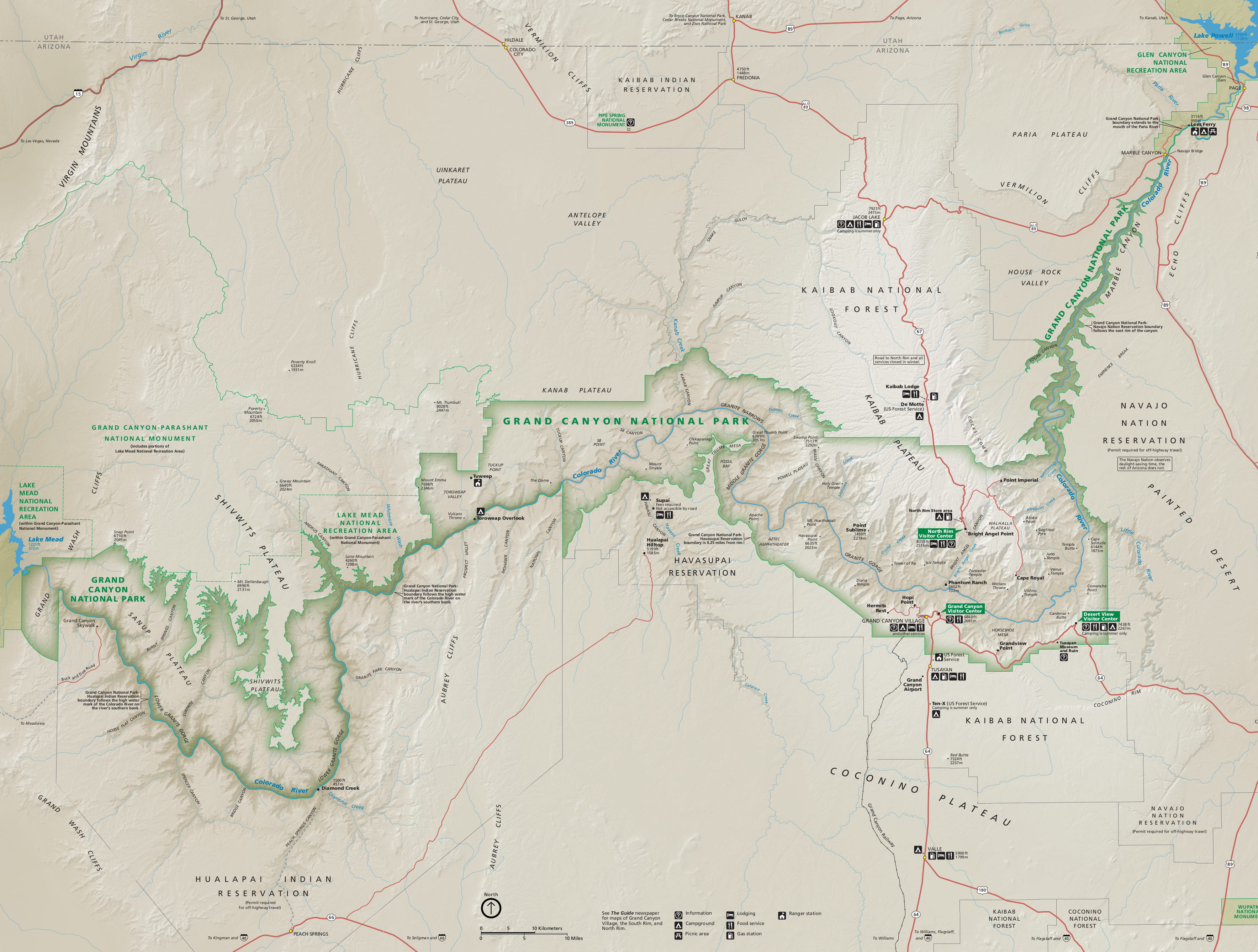 This is the newest Grand Canyon National Park map, and shows the entire national park including the far-flung less-visited locations. Click the image to view a full size map or download the PDF.
Grand Canyon trail maps
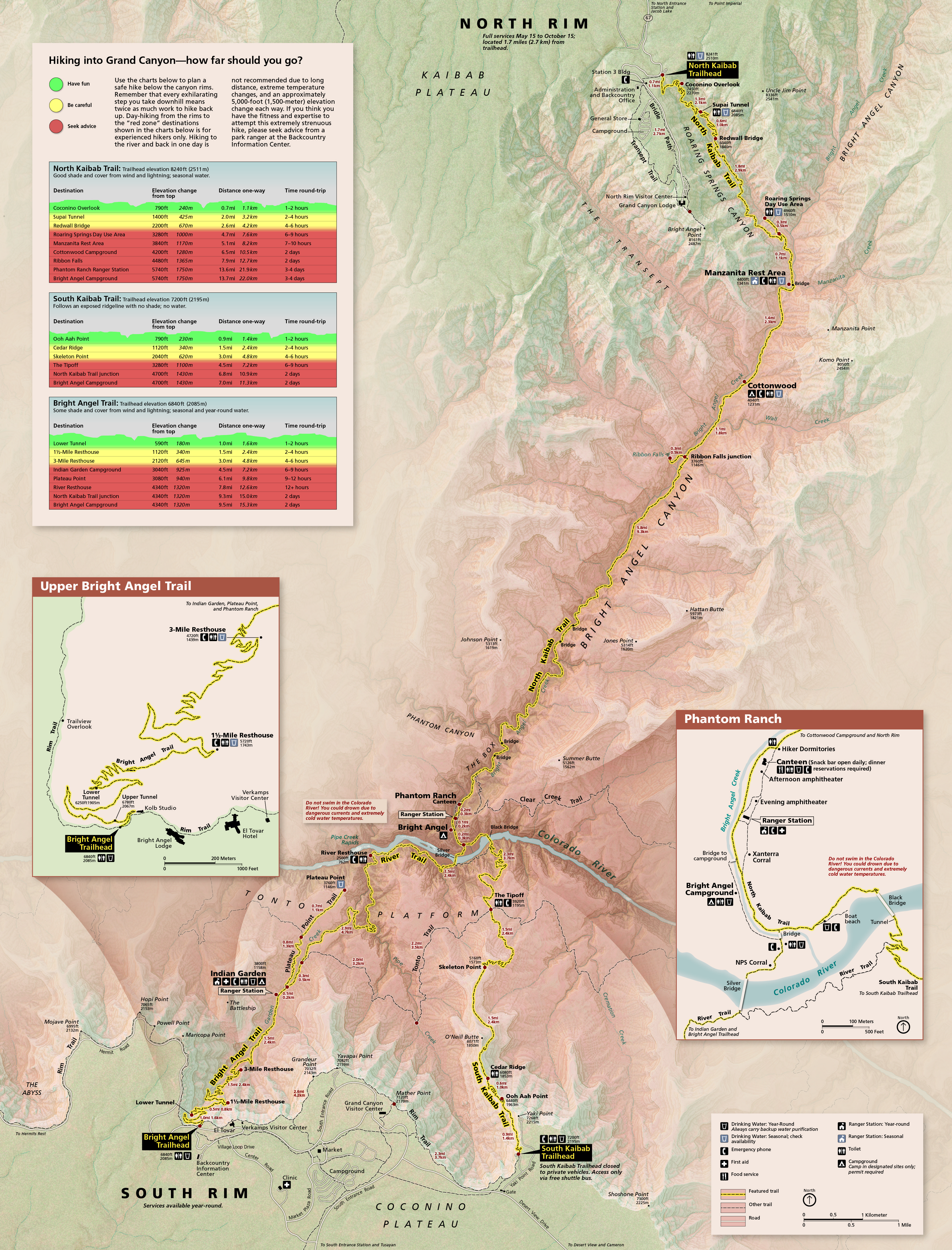 Here’s a Grand Canyon trail map, showing the most popular trails accessed from the North and South Rims. The tables on elevation change, distance, and time estimate are especially useful.
 The Grand Canyon day hike difficulty map plots the Bright Angel Trail, South Kaibab Trail, and North Kaibab Trail on a canyon cross-section, labeling the difficulty of reaching various points of interest.
 The Hermit Trail map shows a few recommended day hike destinations that drop down into the Grand Canyon on the Hermit Trail, located at the end of Hermit Road at Hermits Rest. (Notice a theme?)
 This Grandview Trail map focuses on the Grandview Trail, which departs from Grandview Point. Note that this is a very steep, rarely-maintained trail with no water sources. For experienced desert hikers only!
 Here’s a Rim Trail map, which is mostly paved and relatively flat along its 13 miles. It stretches from Hermits Rest to the South Kaibab Trailhead and is an awesome choice for a flat hike with great views.
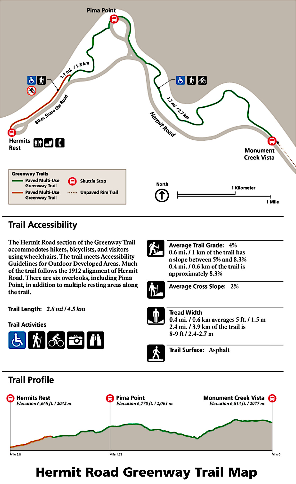 The Hermit Road Greenway Trail map shows a section of trail that parallels the Hermits Rest road and is open to cycling and e-bikes. An additional segment meets accessibility guidelines for wheelchairs.
 The Bright Angel Point trail map shows this short but steep paved trail to an incredible view looking south over the Grand Canyon from the North Rim. Note the fossils and points of interest labeled on the map.
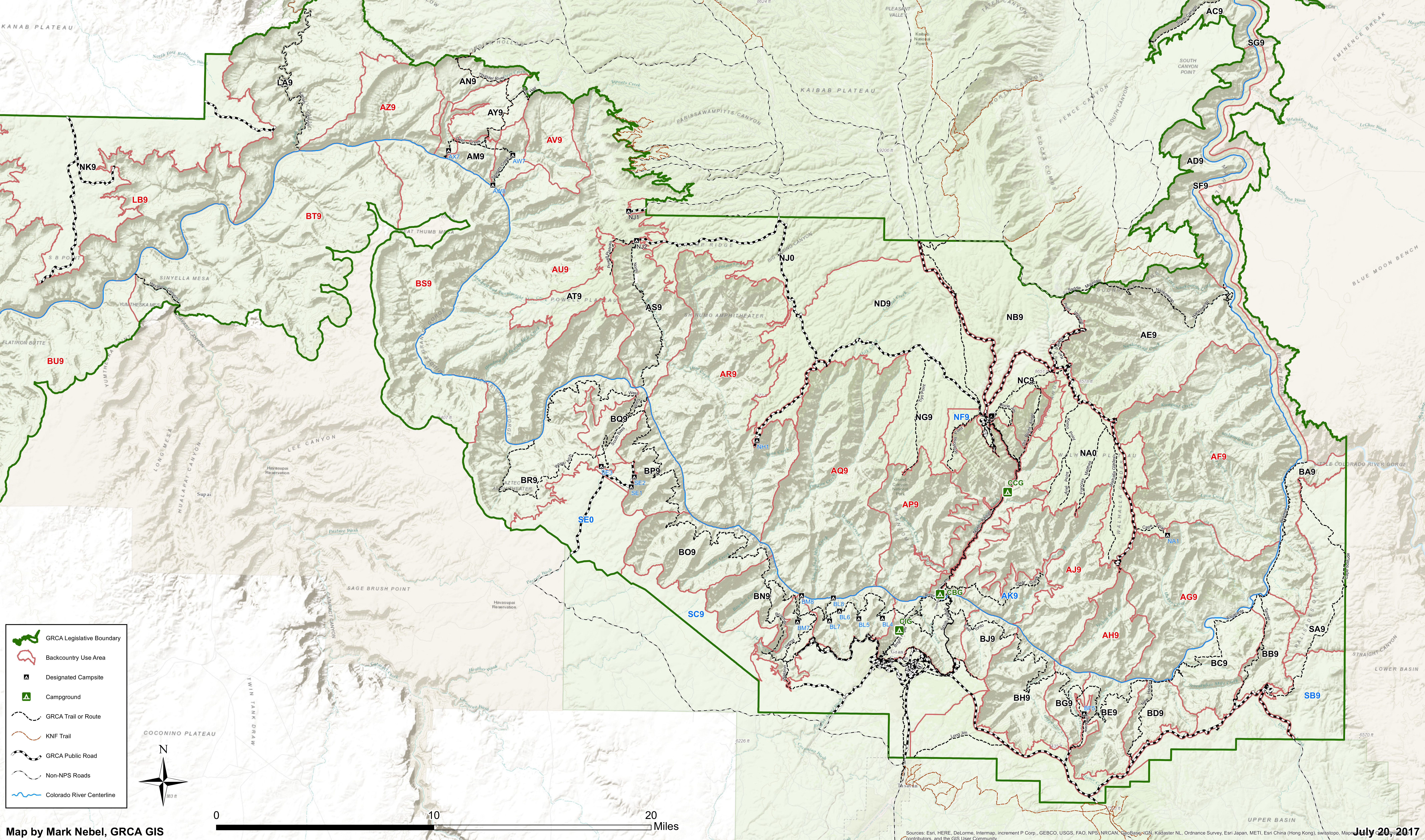 The Grand Canyon backcountry trails map is incredibly high-resolution and shows all maintained trails and established backcountry campsites within Grand Canyon National Park.
 If you’re going to be doing a lot of hiking or any backpacking in the Grand Canyon, you’ll want a detailed trail map like the National Geographic Trails Illustrated map, which includes the area between the North and South Rims (Bright Angel and South Kaibab Trails). If you want maps that show more of the park backcountry, check out the Grand Canyon East and Grand Canyon West maps (which includes Havasupai).
Grand Canyon shuttle maps
 The Grand Canyon shuttle map zooms in on Grand Canyon Village and shows each of the four shuttle routes, though not the purple and red loops in their entirety. See the maps below for route-specific information.
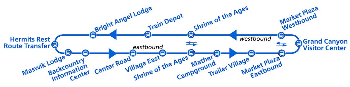 The blue loop shuttle map shows this central Village Route that ferries visitors between lodges, campgrounds, visitor centers, and other points of interest. It connects to the red loop to the west and orange loop to the east.
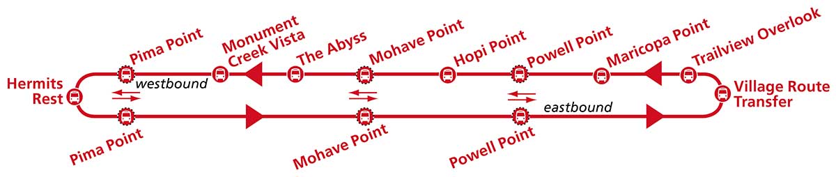 Here’s a red loop shuttle map, also known as the Hermits Rest route. This route connects the main Village Route (blue) with the Hermit Road and associated overlooks to the west. It typically runs March 1 to November 30.
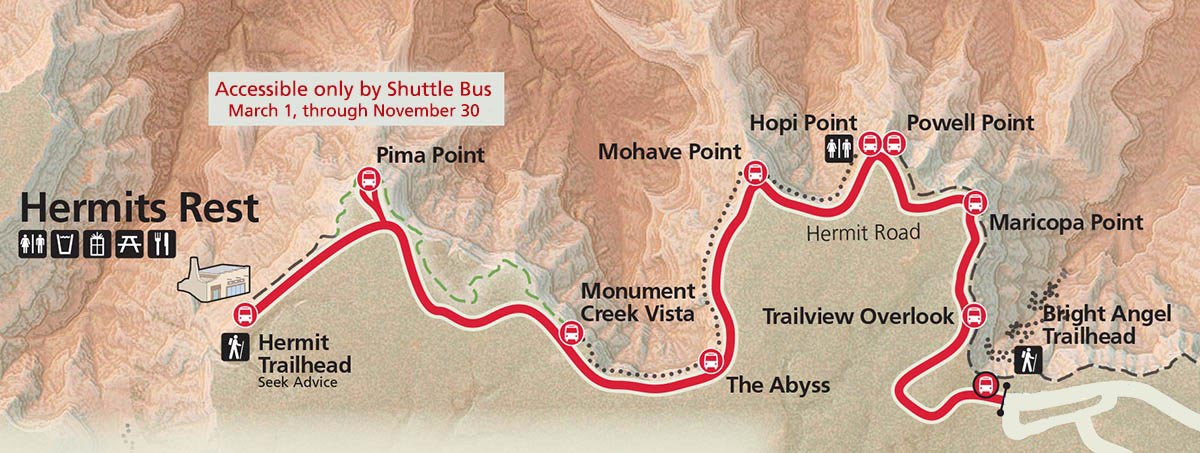 This alternate red loop shuttle map overlays the stops above on a park map. While the blue and orange loops are fully shown on the map on top of this section, the red loop doesn’t fit, hence the need for this separate map.
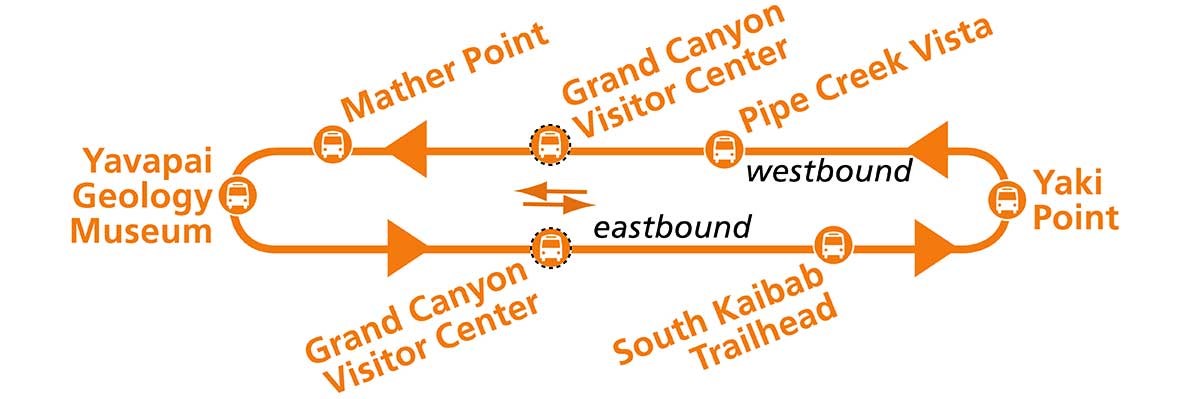 The orange loop shuttle map shows the Kaibab/Rim Route that connects to the east end of the blue Village Route above and brings visitors to locations including Yaki Point and the South Kaibab Trailhead.
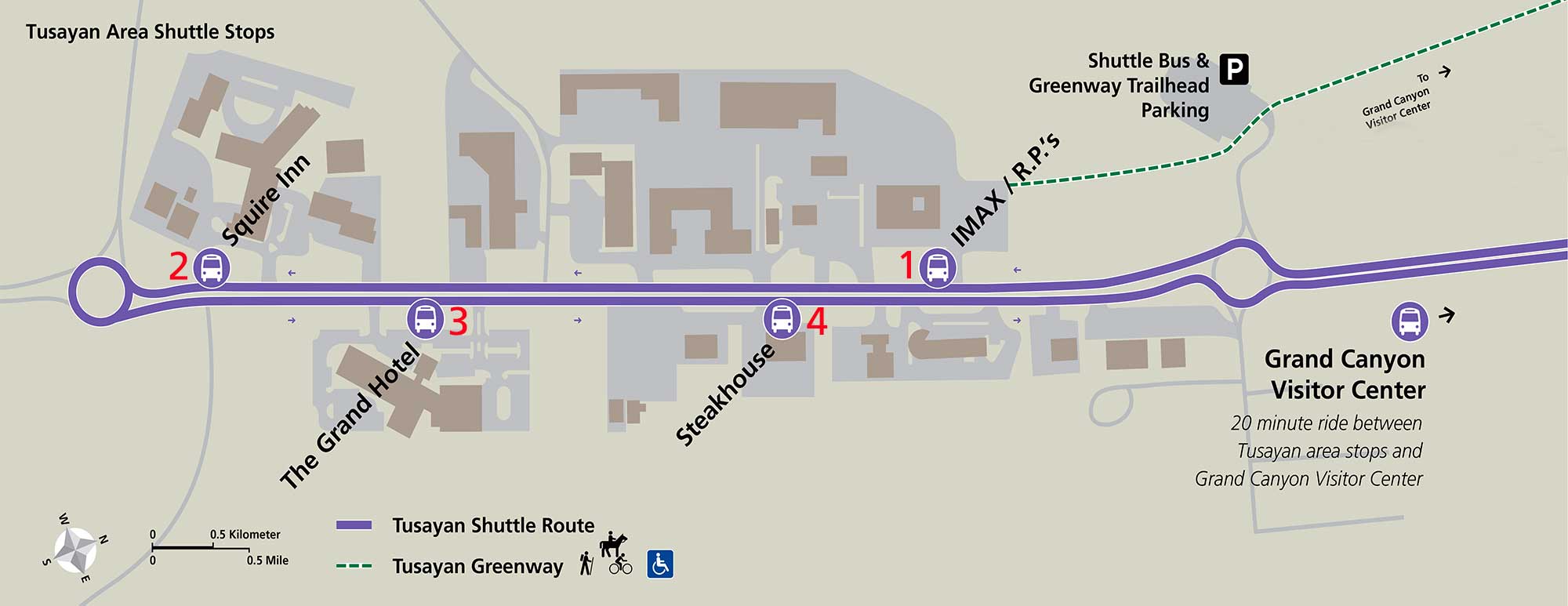 This is a Tusayan shuttle map, also known as the purple route. While the other three routes shuttle visitors within the national park, this route brings in visitors from the gateway town of Tusayan during peak season.
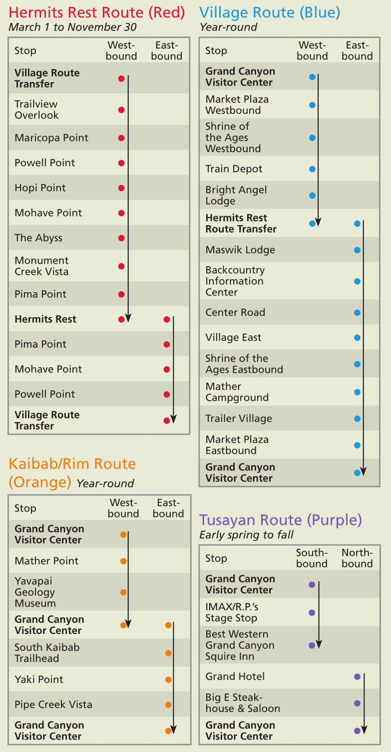 This alternate shuttle map shows all four routes in a single graphic. Personally I find this one a little less intuitive than the ones above, but the NPS distributes it widely on their South Rim pocket guide.
Grand Canyon campground maps
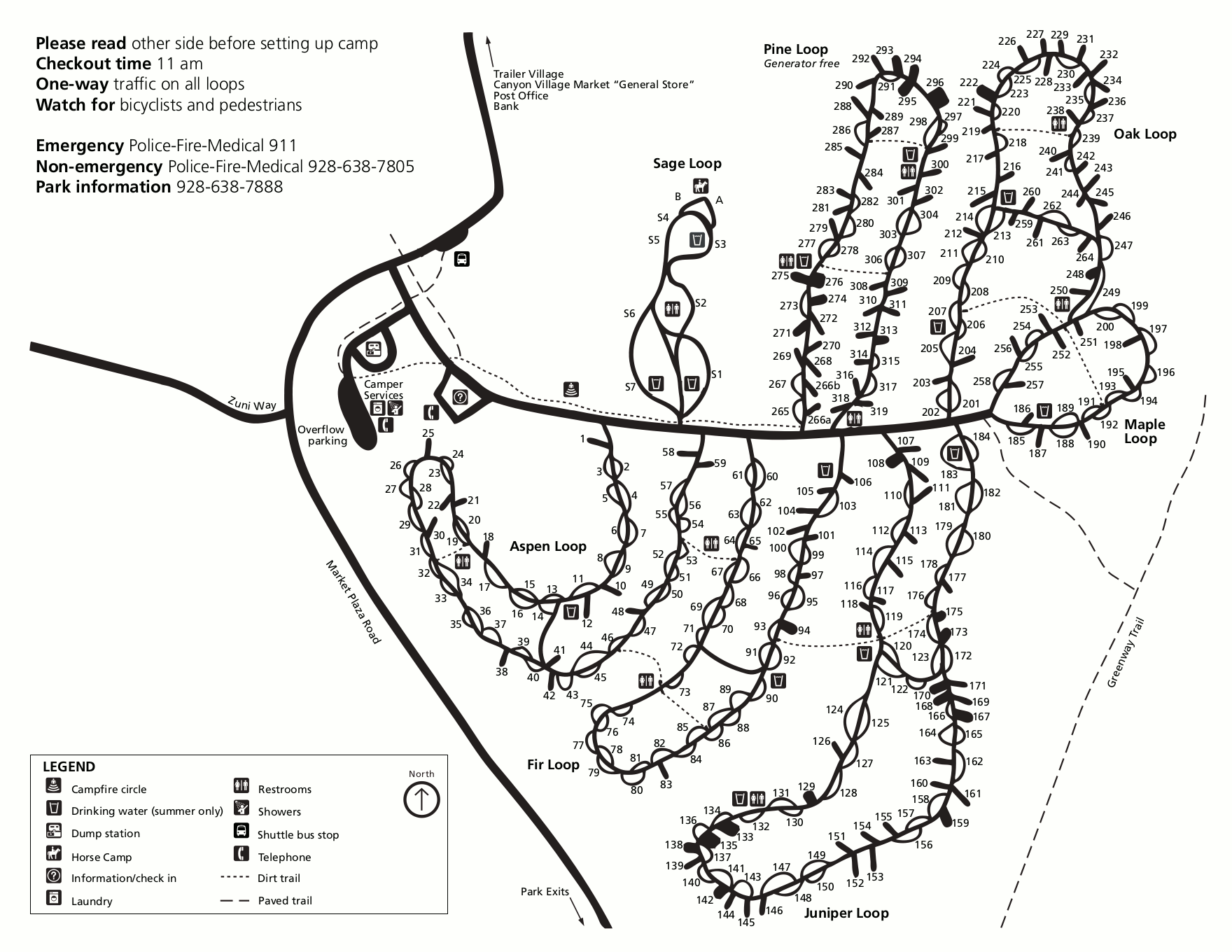 This is the Mather Campground map, located on the South Rim in Grand Canyon Village, southeast of the lodging and southwest of the visitor center. This is the most popular campground in the park.
 This is the Desert View Campground map. Unique for national park campground maps, it not only shows where the sites are in relation to each other, but it also displays whether they’re pull-through or back-in sites.
 This is the North Rim Campground map. It includes the group sites, tent-only sites, and hiker and cyclist camping, and shows the campground in relation to the Transept Trail.
Grand Canyon lodging map
 To browse some Grand Canyon lodging options, the image to the right will open an Expedia interactive Grand Canyon lodging map. By default, this map zooms in on Grand Canyon Village on the South Rim, but if you pan it down a bit you can also find lodging in Tusayan, just outside the park boundary (and often cheaper). Or compare reviews, prices, and photos of the best rated Grand Canyon lodging on Expedia.
Grand Canyon South Rim maps
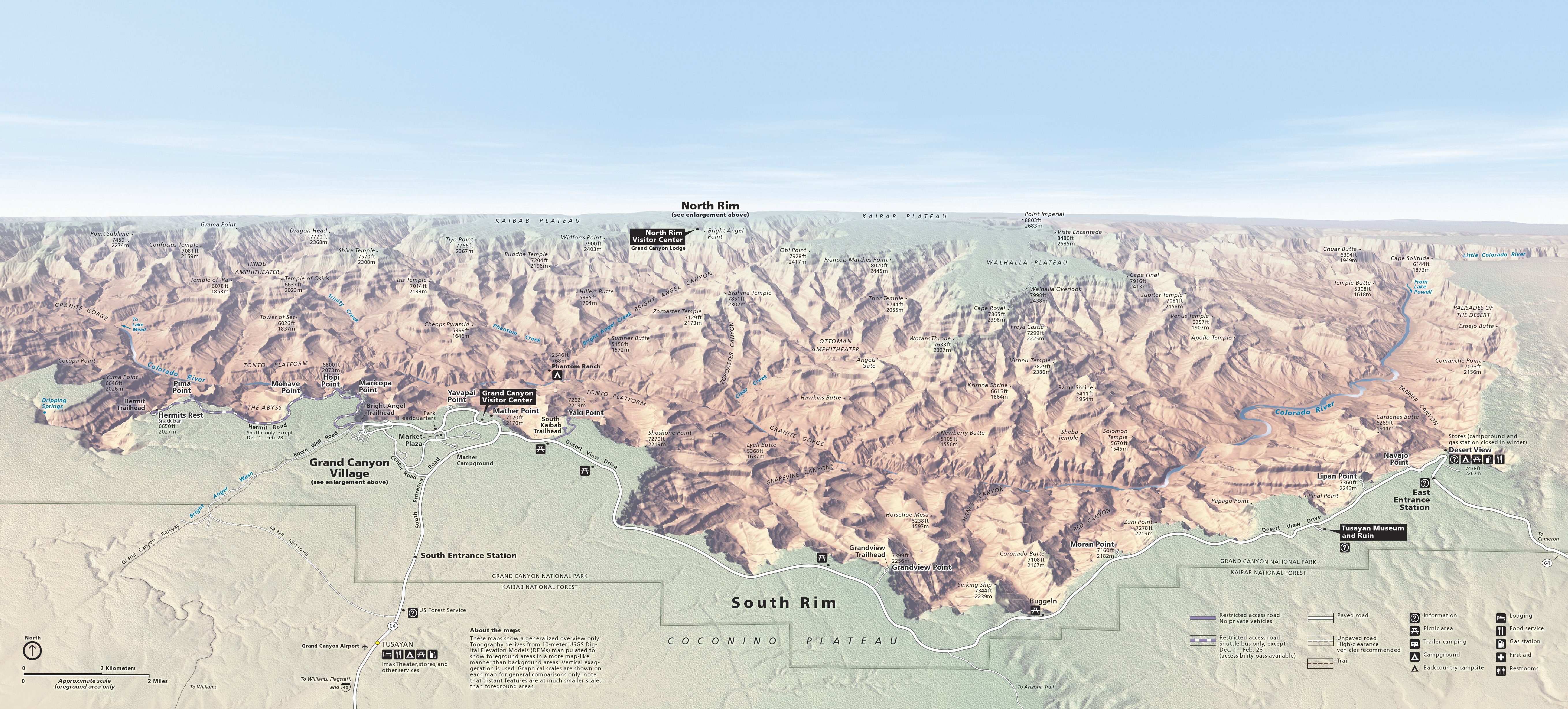 This is the main Grand Canyon South Rim map—the primary developed area of the national park featuring the most hotels and services. Click the image to view a full size map or download the PDF.
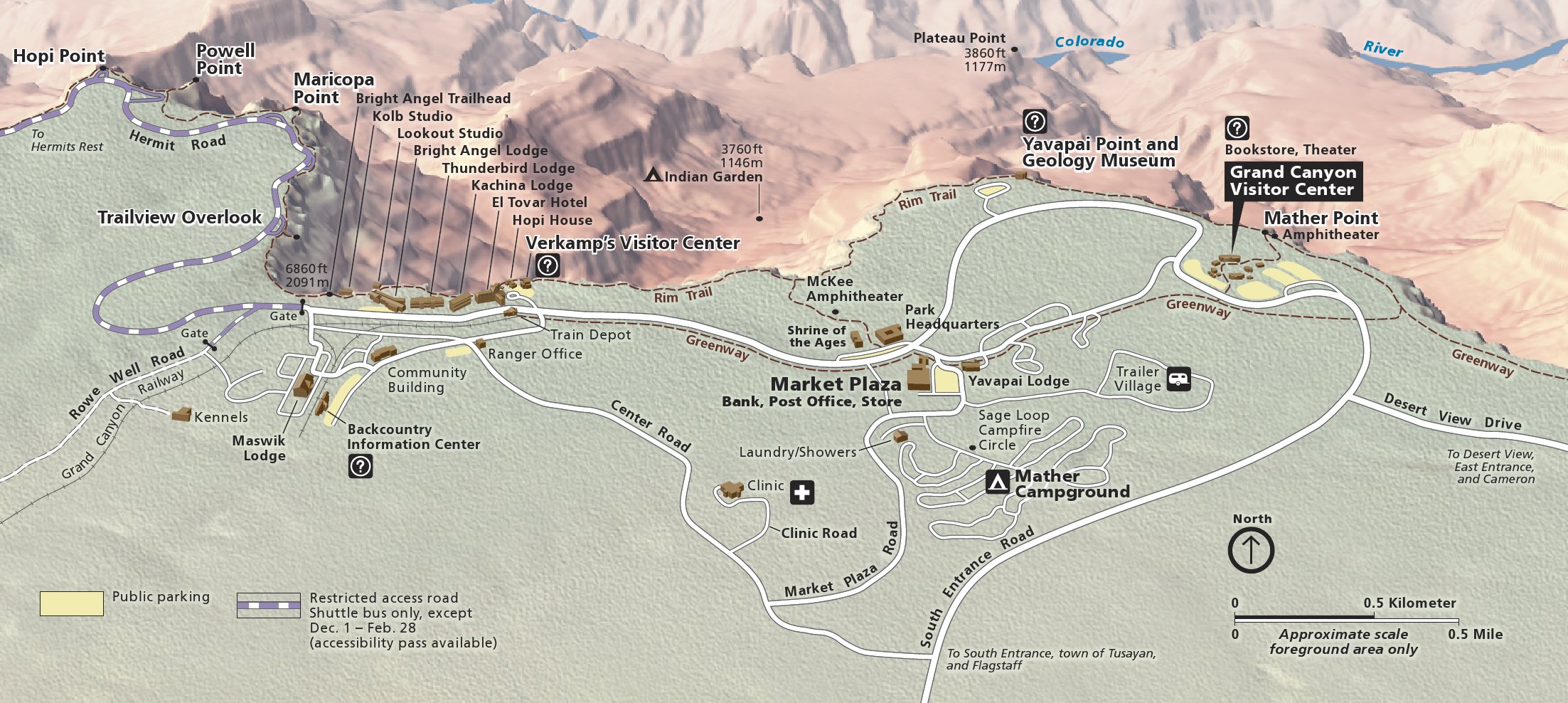 This is a Grand Canyon Village map, located on the South Rim. This is where most of the hotels and the largest campground are located. Click the image to view a full size map or download the PDF.
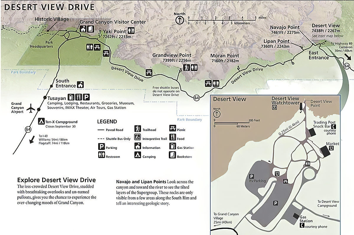 The Desert View Drive map shows the rest of the South Rim away from Grand Canyon Village and the Hermit Road. Overlooks at Moran Point, Grandview Point, Lipan Point, and Navajo Point are identified.
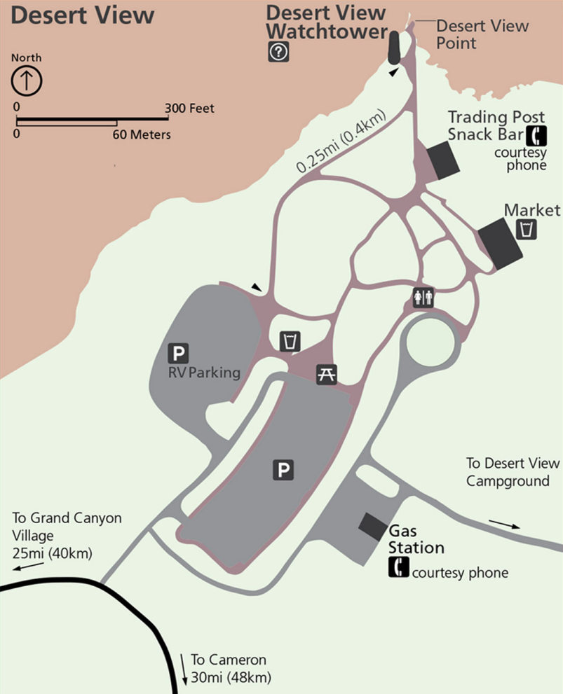 Here’s a Desert View area map cropped from the one above, zooming in on the Desert View Watchtower and surrounding visitor services. This is the first place you’ll arrive if entering from the southeast entrance.
Grand Canyon North Rim maps
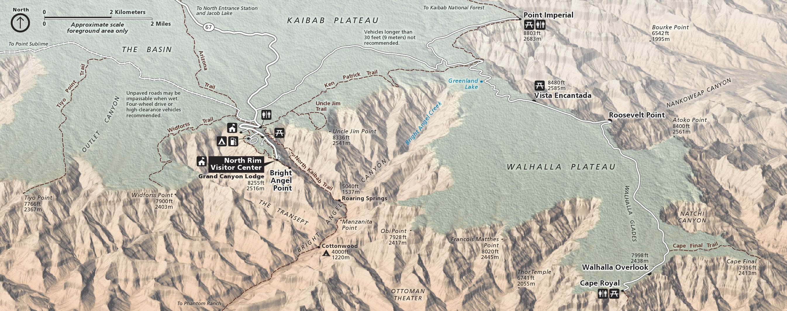 This is the main Grand Canyon North Rim map—a quieter, more laid-back version of the South Rim that’s only open seasonally. Click the image to view a full size map or download the PDF.
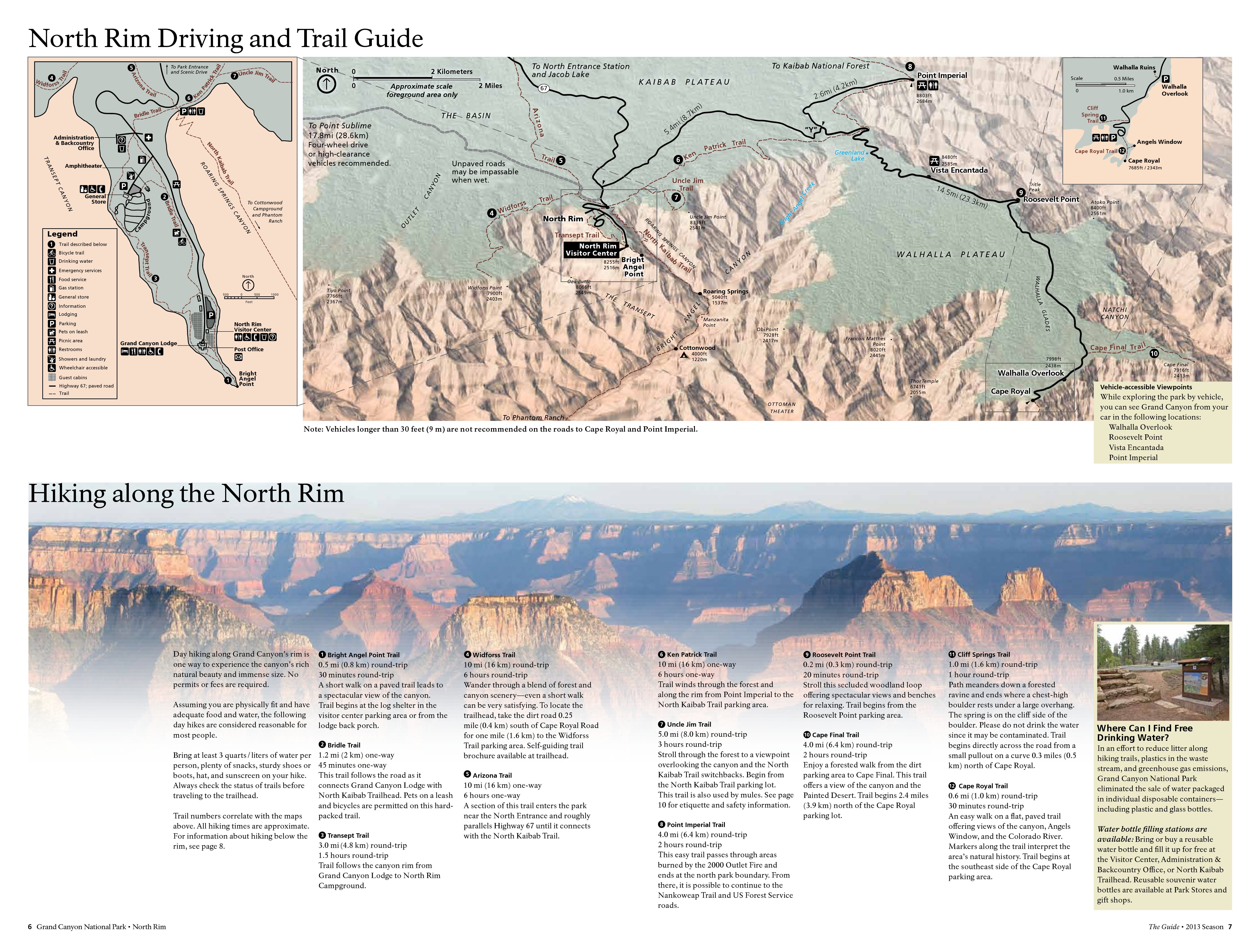 This North Rim detail map includes the map above as well as hike descriptions and inset maps of Cape Royal and North Rim visitor services. Click the image to view a full size map or download the PDF.
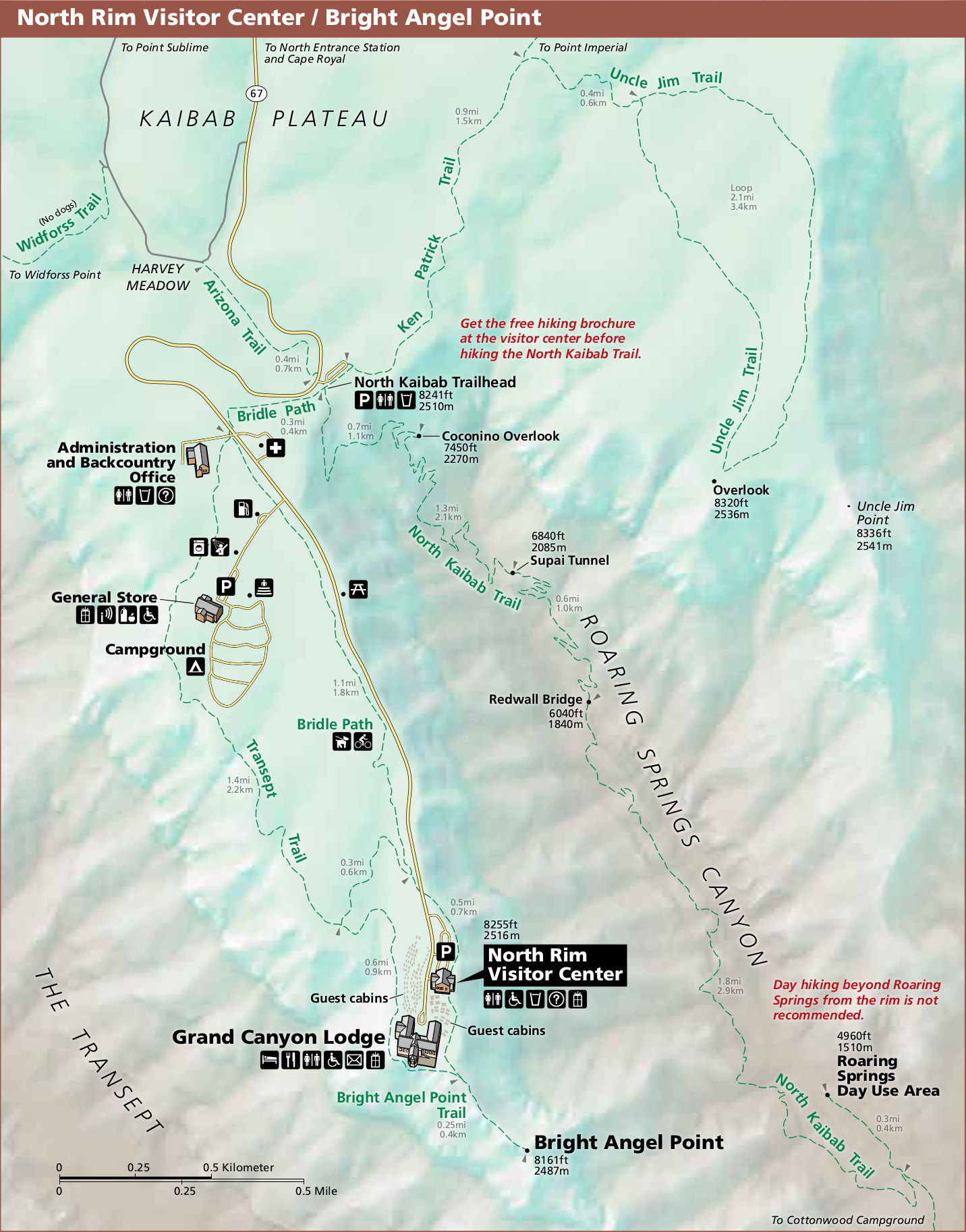 Here’s a North Rim visitor center area map, focusing on Bright Angel Point, North Kaibab trailhead, Grand Canyon Lodge, and the surrounding trails, roads, campgrounds, and attractions.
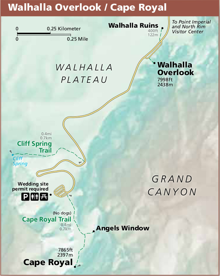 This North Rim Cape Royal map zooms in on Walhalla Plateau and where the road ends at Cape Royal, showing the Cape Royal Trail to Angels Window and the spectacular viewpoint.
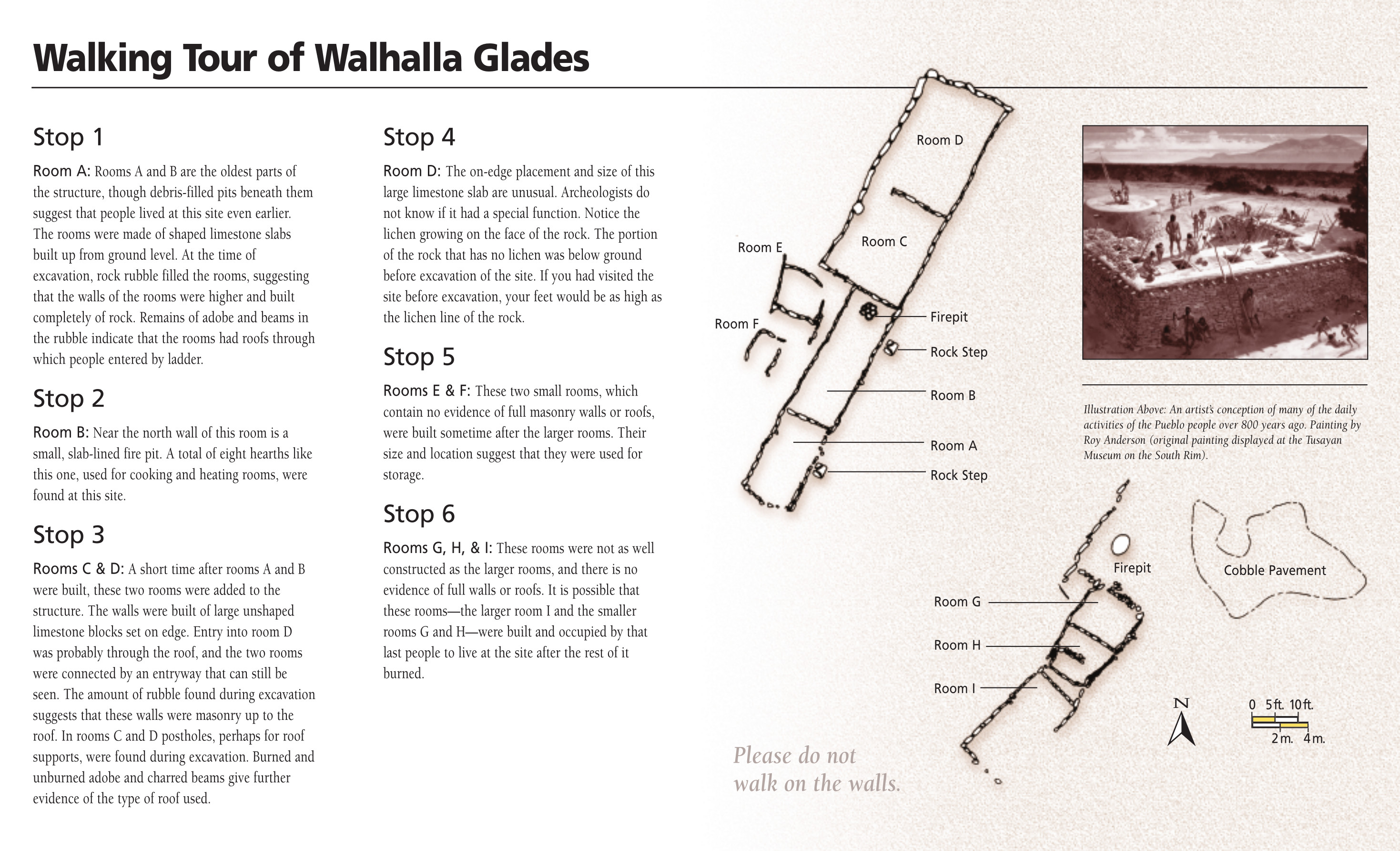 The Walhalla Glades map provides a walking tour of the Walhalla Glades Pueblo, located on the way to Cape Royal. Follow the six stops to learn about the people who called this archeological site home.
 This Cape Royal Road map shows exactly where you’ll find Walhalla Glades, with an inset map that zooms in on the Glades as well as the Cliff Spring Trail, Cape Royal Trail, and Angels Window.
Phantom Ranch maps
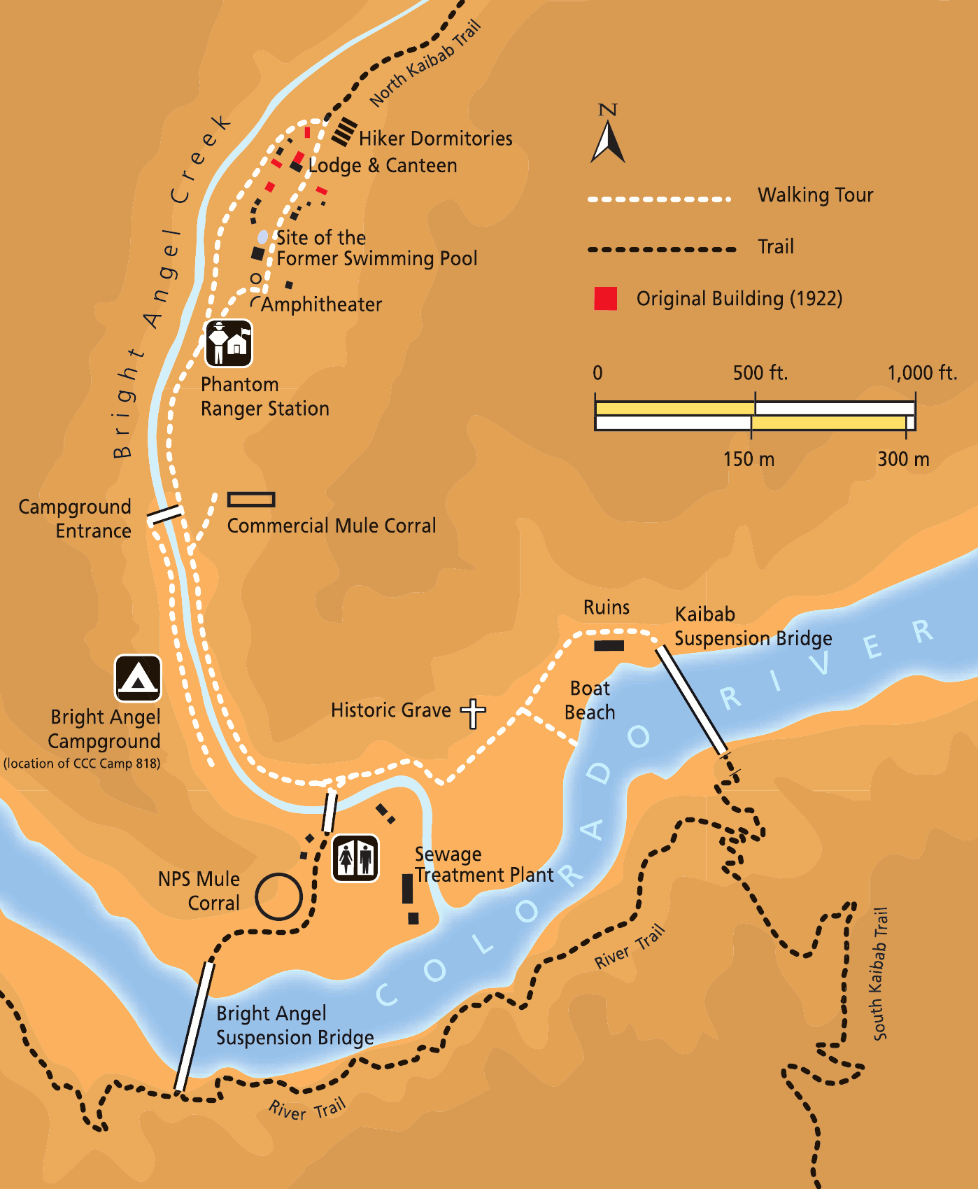 This is a map of Phantom Ranch, showing the ranger station, dorms, and Bright Angel Campground at the bottom of the Grand Canyon along the Colorado River. You can hike here from the North or South Rims.
 The simplified Phantom Ranch map might not be quite as colorful as the one above, but I find it easier to read. This map is also included as an inset in the Grand Canyon trail map near the top of this page.
Regional Grand Canyon maps
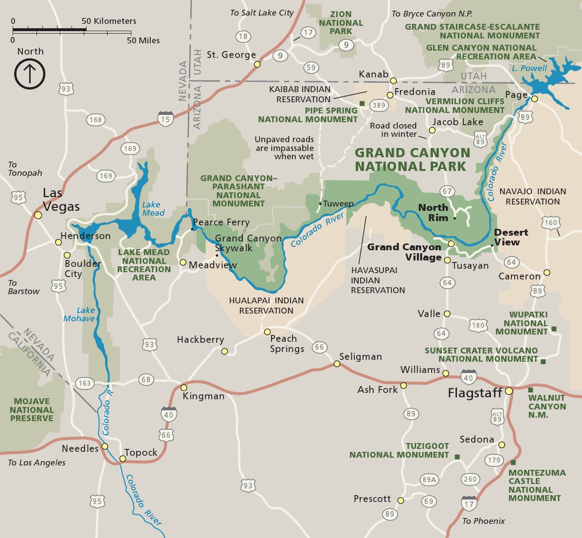 Need to zoom out? Here’s a map of roads near Grand Canyon, showing driving directions between the rims or to Las Vegas. Click the image to view a full size map or download the PDF.
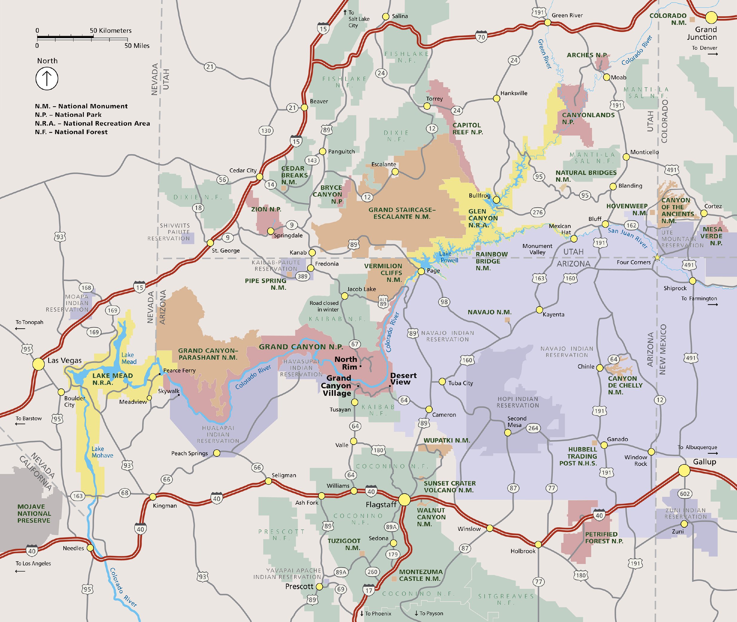 This map shows each of the couple dozen national park sites within a day’s drive of the Grand Canyon. Click the image to view a full size map or download the PDF.
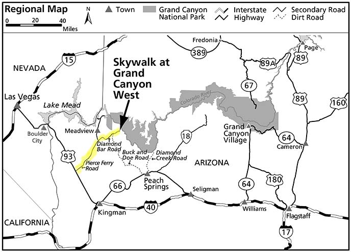 The Grand Canyon Skywalk map shows the actual location of the Skywalk. It is not within Grand Canyon National Park but is approximately a five-hour drive from the South Rim on Hualapai land.
Grand Canyon parking maps
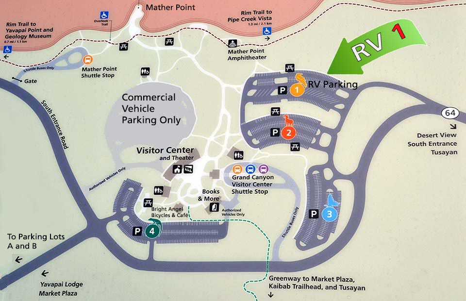 This Grand Canyon Visitor Center parking map shows the four public parking lots near the visitor center. Note that RVs and trailers can only park in Lot 1 in designated spots.
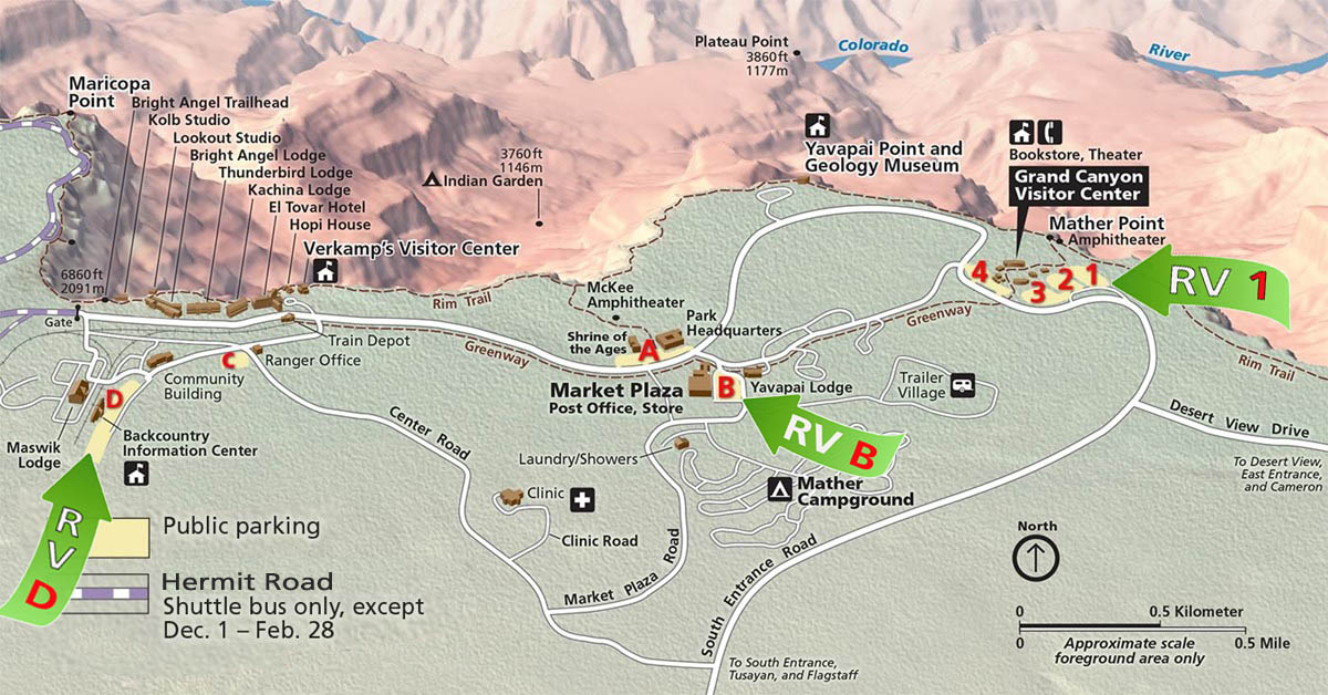 This South Rim parking map shows additional public day use parking, marked by letters A-D. As indicated, note that RVs can be accommodated in B and D, but not A and C.
Grand Canyon EV charging maps
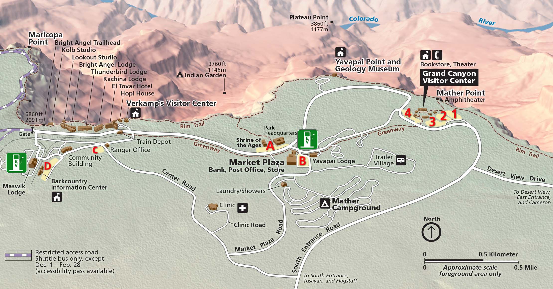 The Grand Canyon electric vehicle charging map shows the two locations of EV chargers with green symbols as of 2023: at the Maswik Lodge and Yavapai Lodge. All chargers are Level II.
 The Maswik Lodge EV charging map shows the seven EV chargers here. Two J1772 chargers are in front of Cliffrose, and four J1772 chargers are to the south, including one handicap charging station.
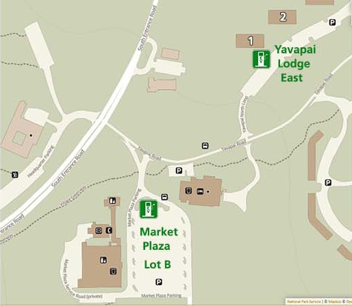 The Yavapai Lodge EV charging map shows the eight EV chargers here. At Yavapai Lodge East, there are three J1772 chargers and three Tesla chargers. In Market Plaza Lot B, there are two chargers (that may be out of service).
Assorted Grand Canyon maps
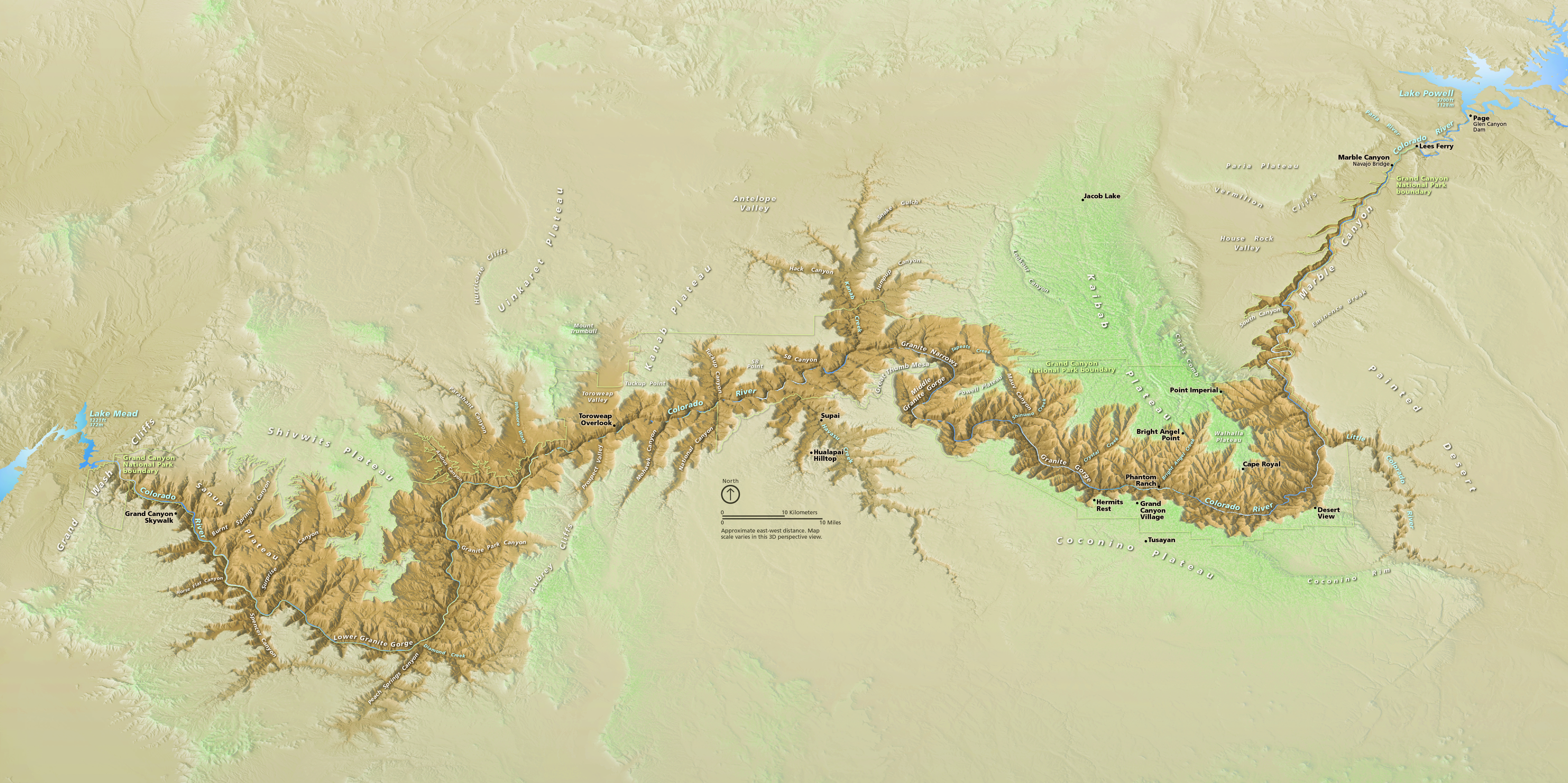 The Grand Canyon aerial 3D map shows the entire length of the Grand Canyon from a stunning oblique perspective — all the way from Lake Powell and Glen Canyon Dam to Lake Mead.
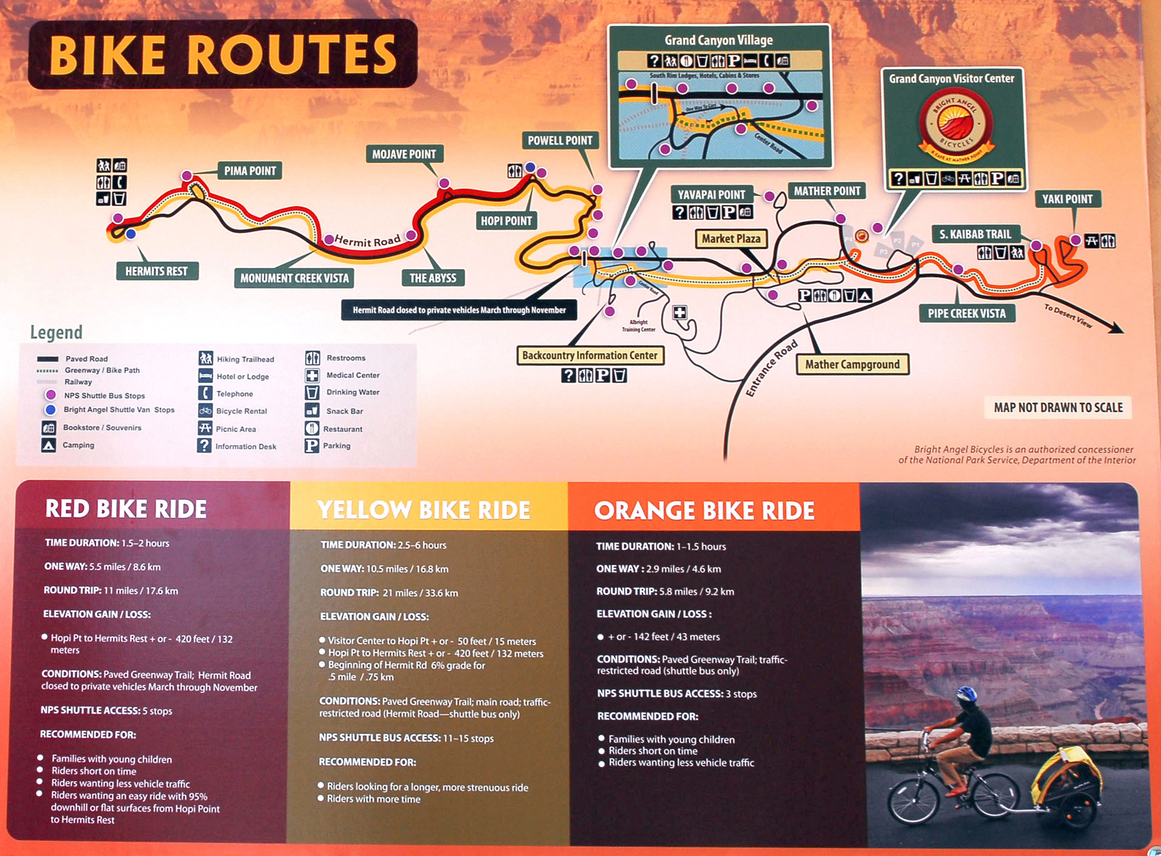 Here’s a Grand Canyon bike map, showing a few routes with information such as length, time, and elevation change. This is a photo of the wall map posted at the concessioner bike rental stand.
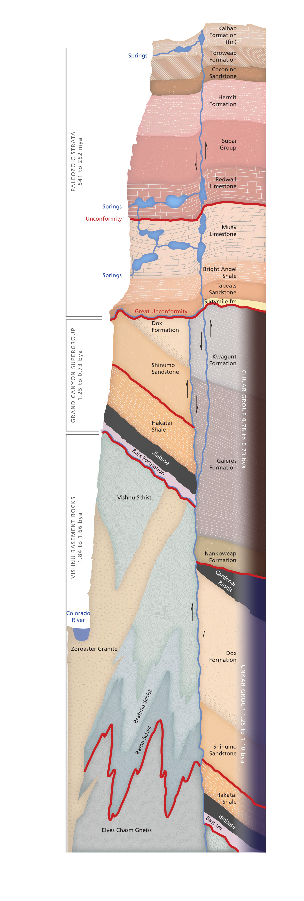 The Grand Canyon cross-section displays the rock layers that make up the canyon walls all the way down to the Colorado River and beyond. Click the image to view a full-size cross section or download the PDF.
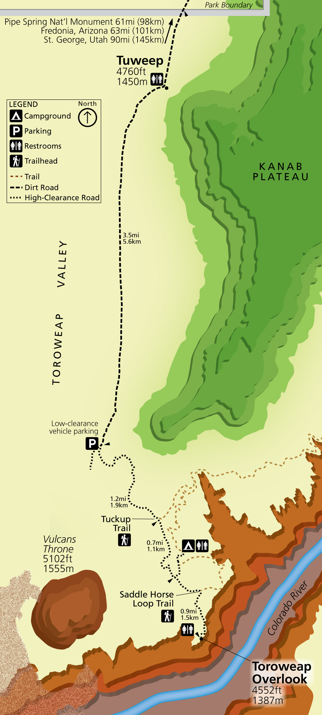 Here’s a Tuweep map. Don’t know what Tuweep is? Then don’t try to go there. You’ll find no water, lodging, gas, or phone service. You’ll need to navigate challenging high-clearance roads and should be entirely self-sufficient.
Grand Canyon accessibility maps
The maps in this section are from Grand Canyon National Park’s 2018 Accessibility Guide.
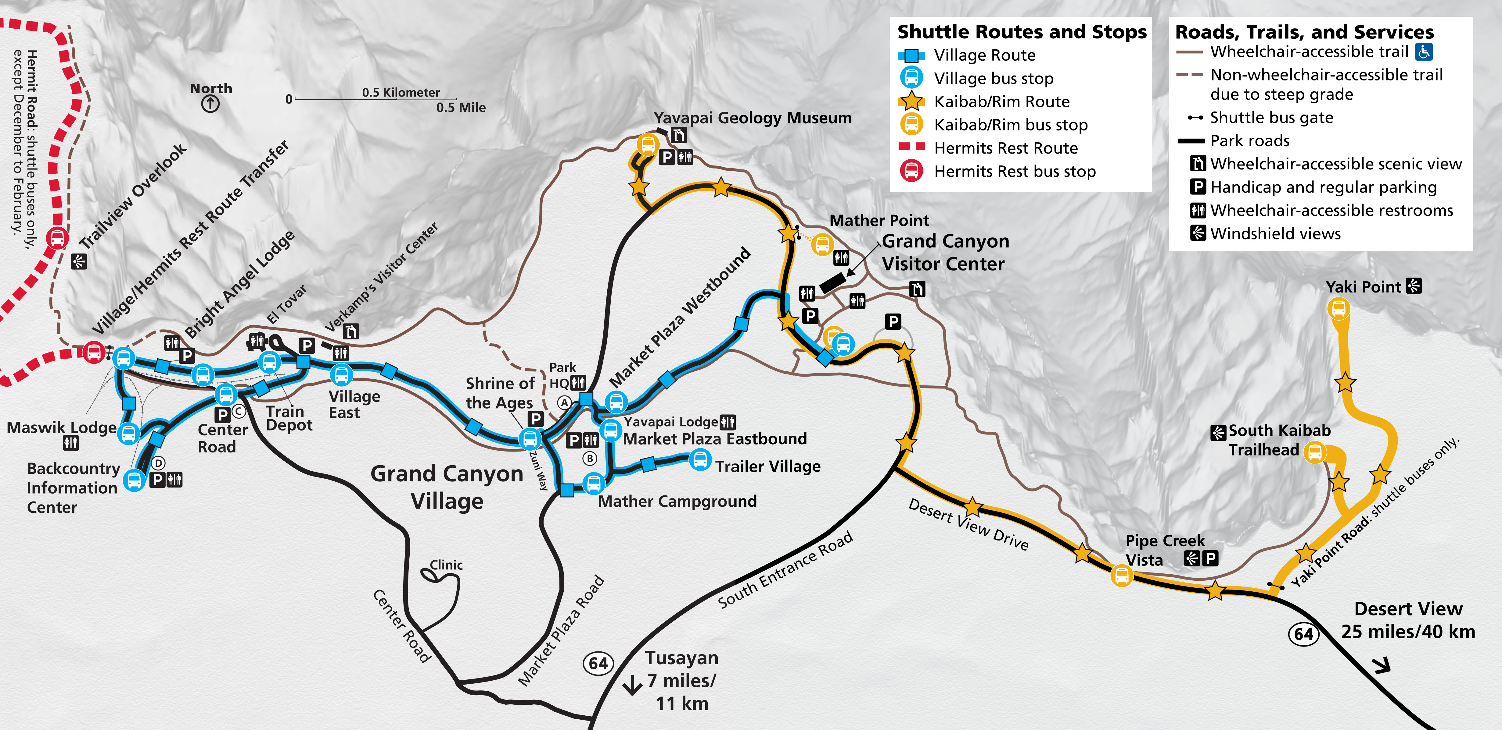 Here’s a Grand Canyon Village accessibility map. It shows you which trails are accessible to wheelchairs and where you’ll find handicap parking and wheelchair-accessible restrooms.
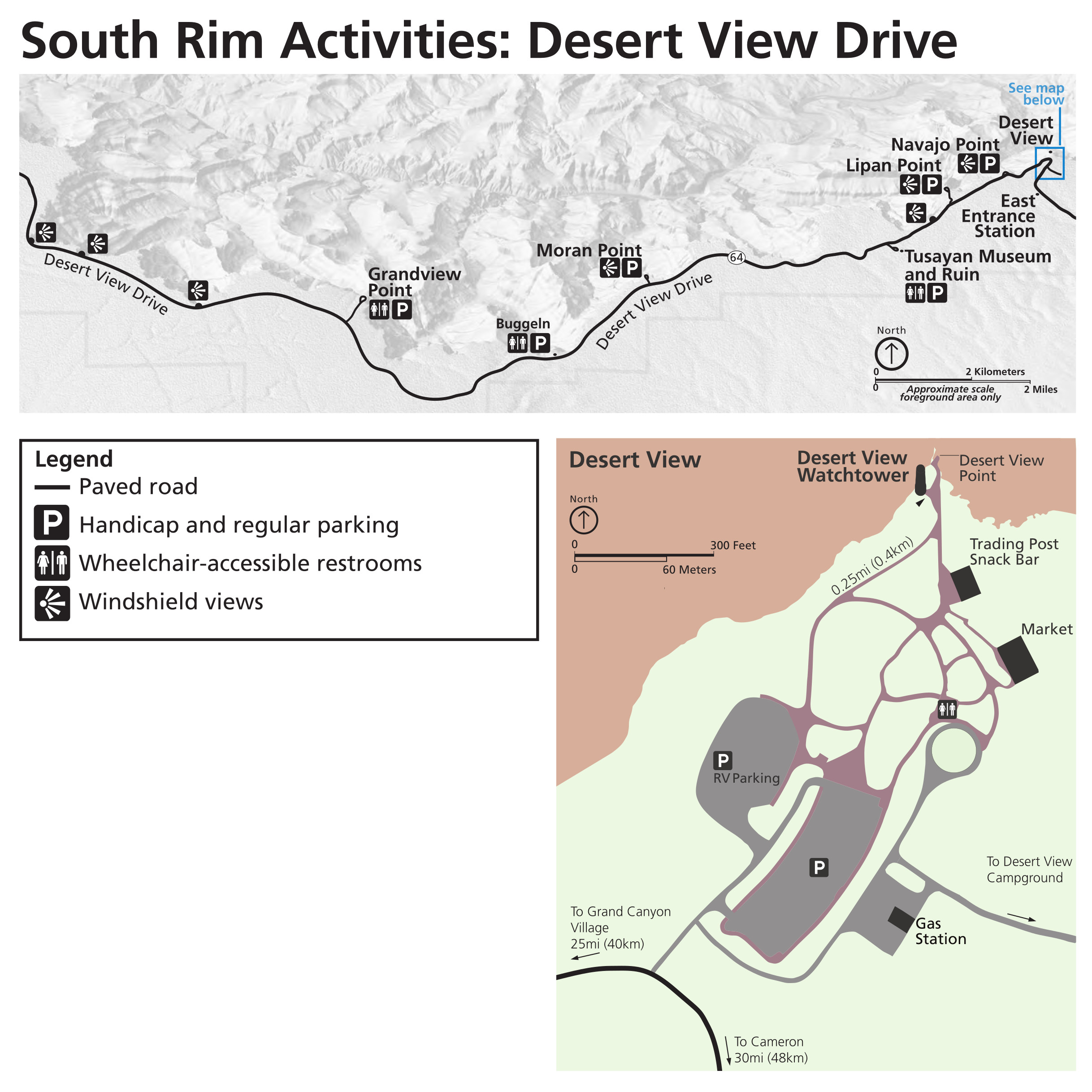 The Desert View Drive accessibility map is especially useful for pointing out “windshield views,” which are views of the canyon you can get without even needing to leave your vehicle.
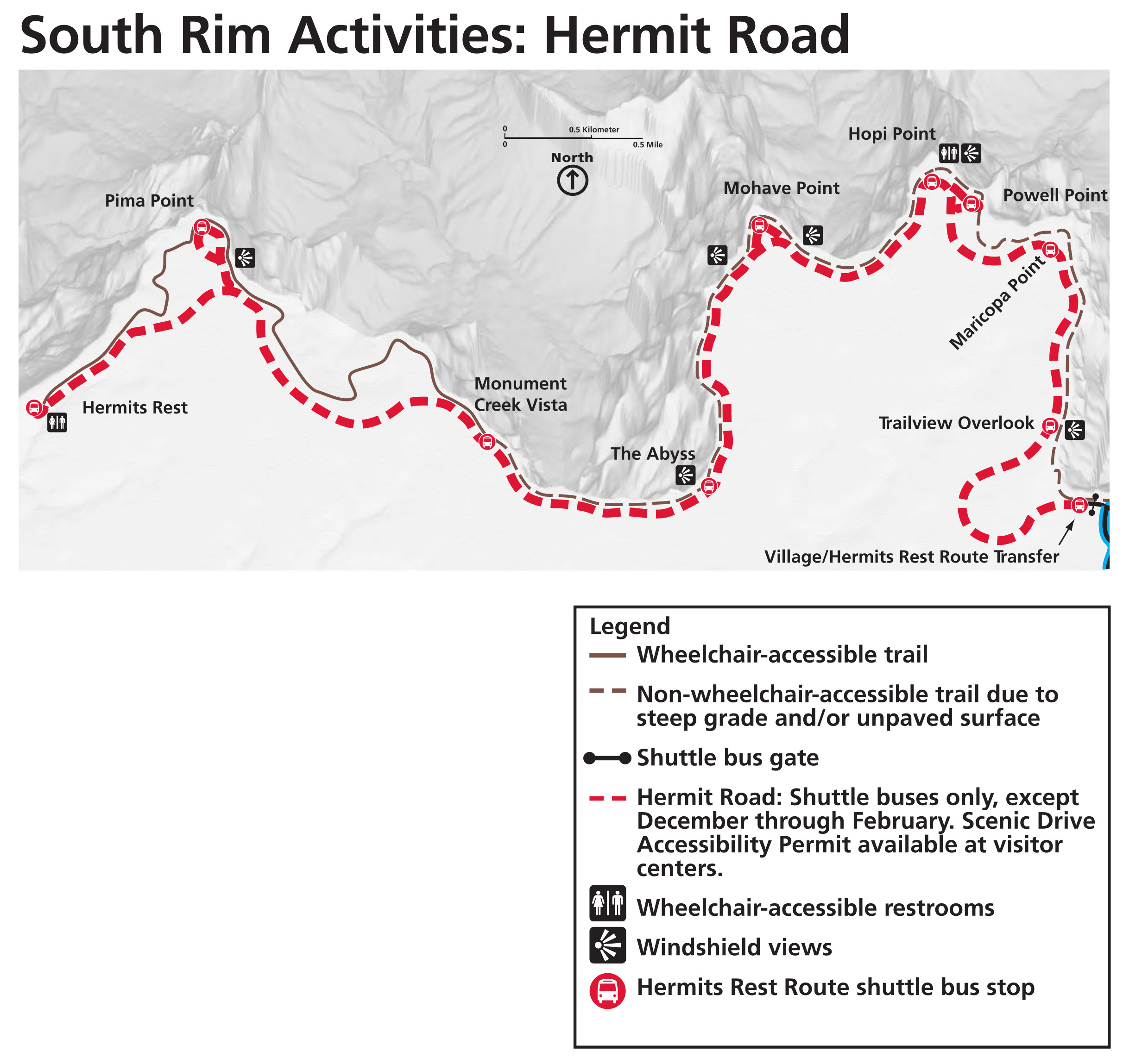 This Hermit Road accessibility map shows the Hermit Road, which is generally closed to passenger vehicles. But a Scenic Drive Accessibility Permit from an entrance station allows those with mobility issues to drive here.
 The North Rim accessibility map shows windshield views of the canyon for those with difficulty leaving their vehicle. Most windshield views can be found along the Cape Royal Road.
Grand Canyon topographic maps
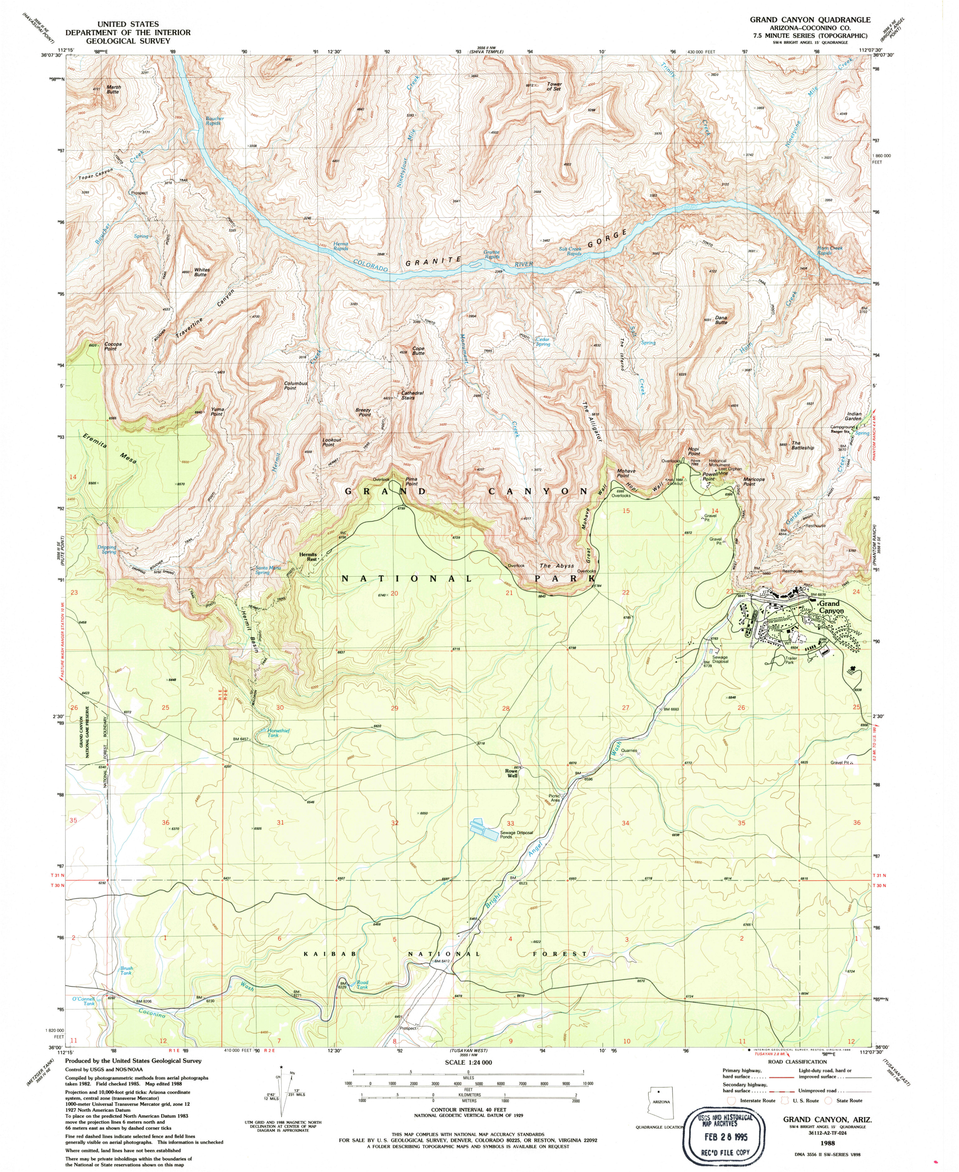 The Grand Canyon South Rim (west) topo map includes the South Rim developed area and upper Bright Angel Trail. Click the image to view a full size map or download the PDF.
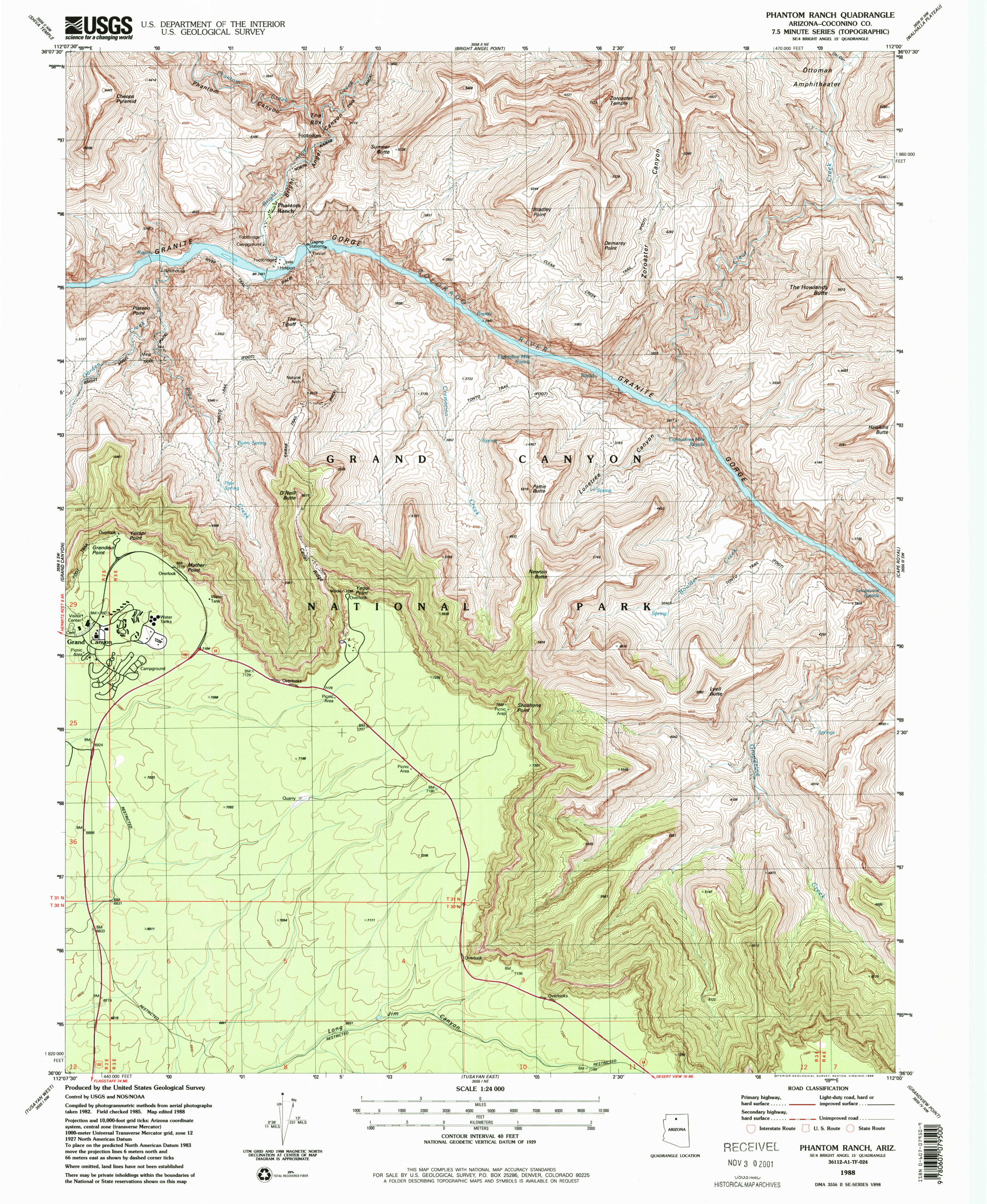 Here’s a South Rim (east) topo map, showing the South Kaibab Trail, Phantom Ranch, and eastern part of the main developed area. Click the image to view a full size map or download the PDF.
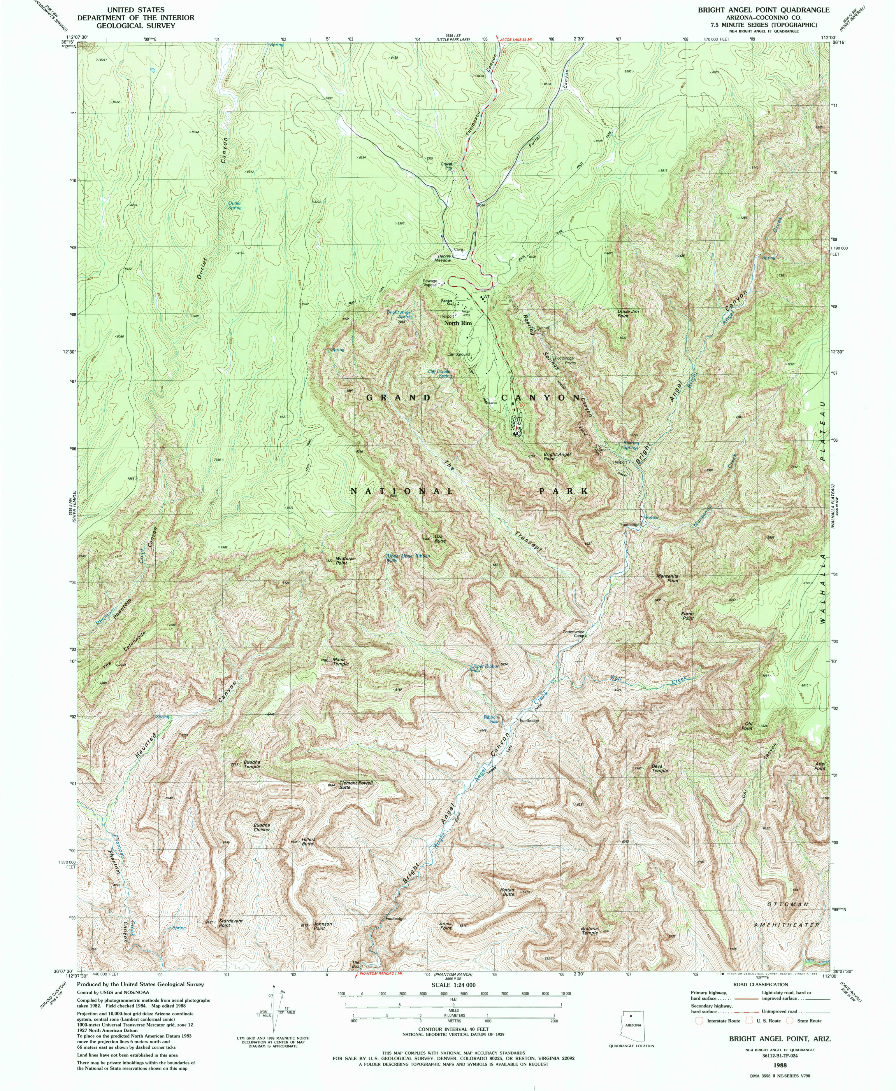 The North Rim topo map shows the North Kaibab Trail leading from the North Rim developed area to Phantom Ranch. Click the image to view a full size map or download the PDF.
 This smaller scale Grand Canyon topo map zooms out to show much of the canyon downstream from the main South Rim developed area, including Havasupai and the popular waterfalls outside the park.
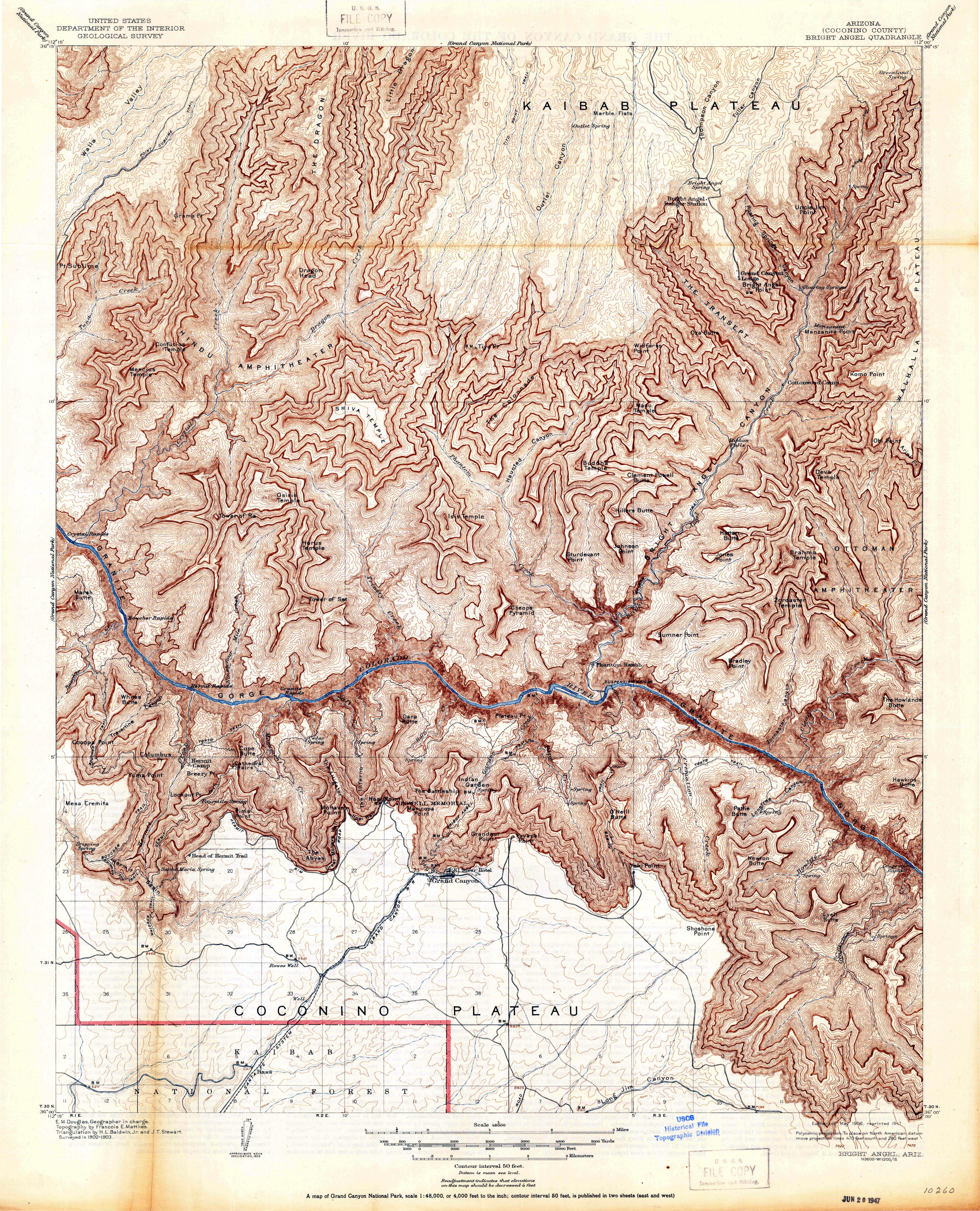 This historical Grand Canyon topo map is from 1906! Note how different the South Rim was back then—pretty much the only way to visit was by riding the train to the El Tovar Hotel.
Grand Canyon foreign language maps
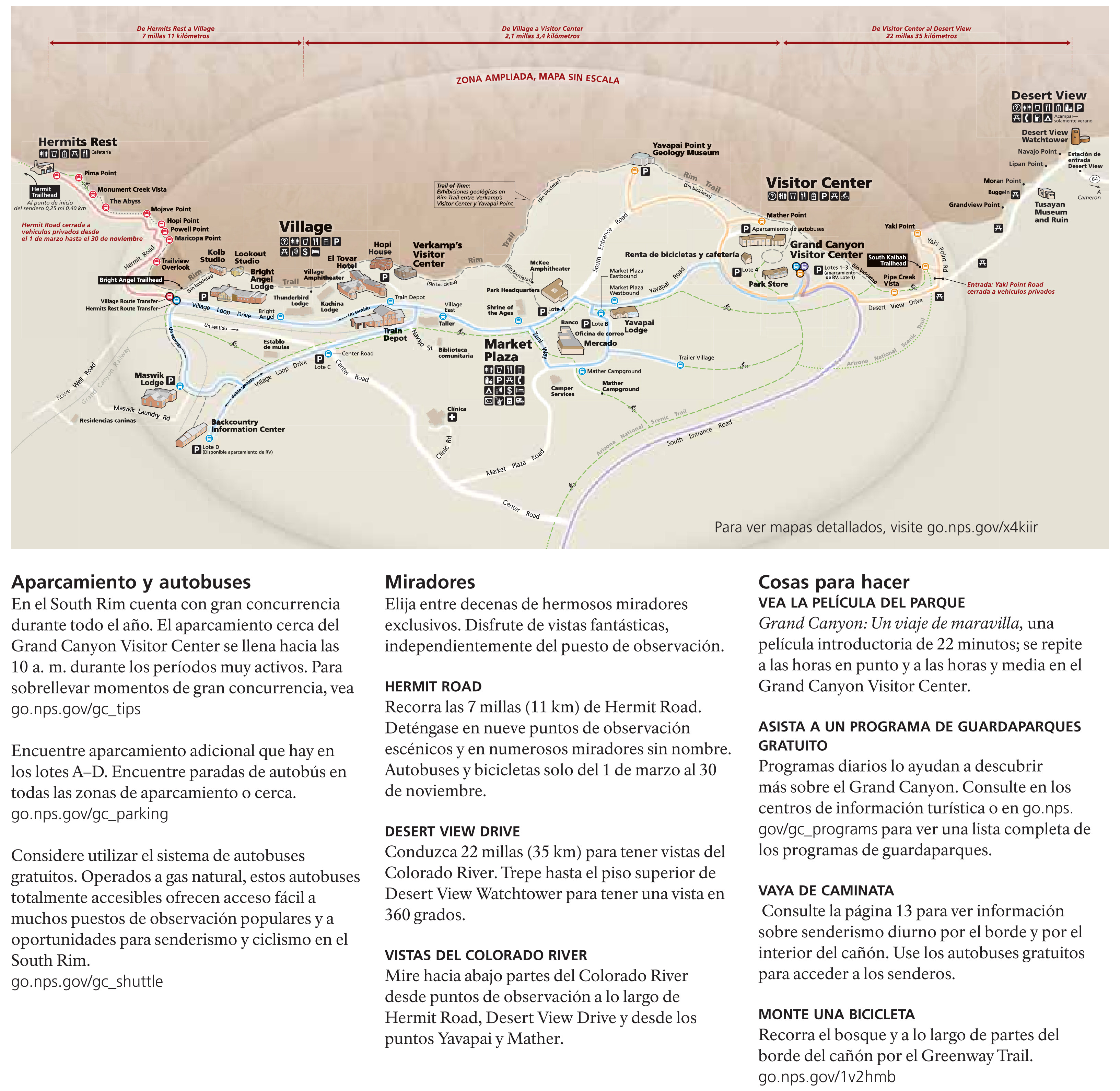
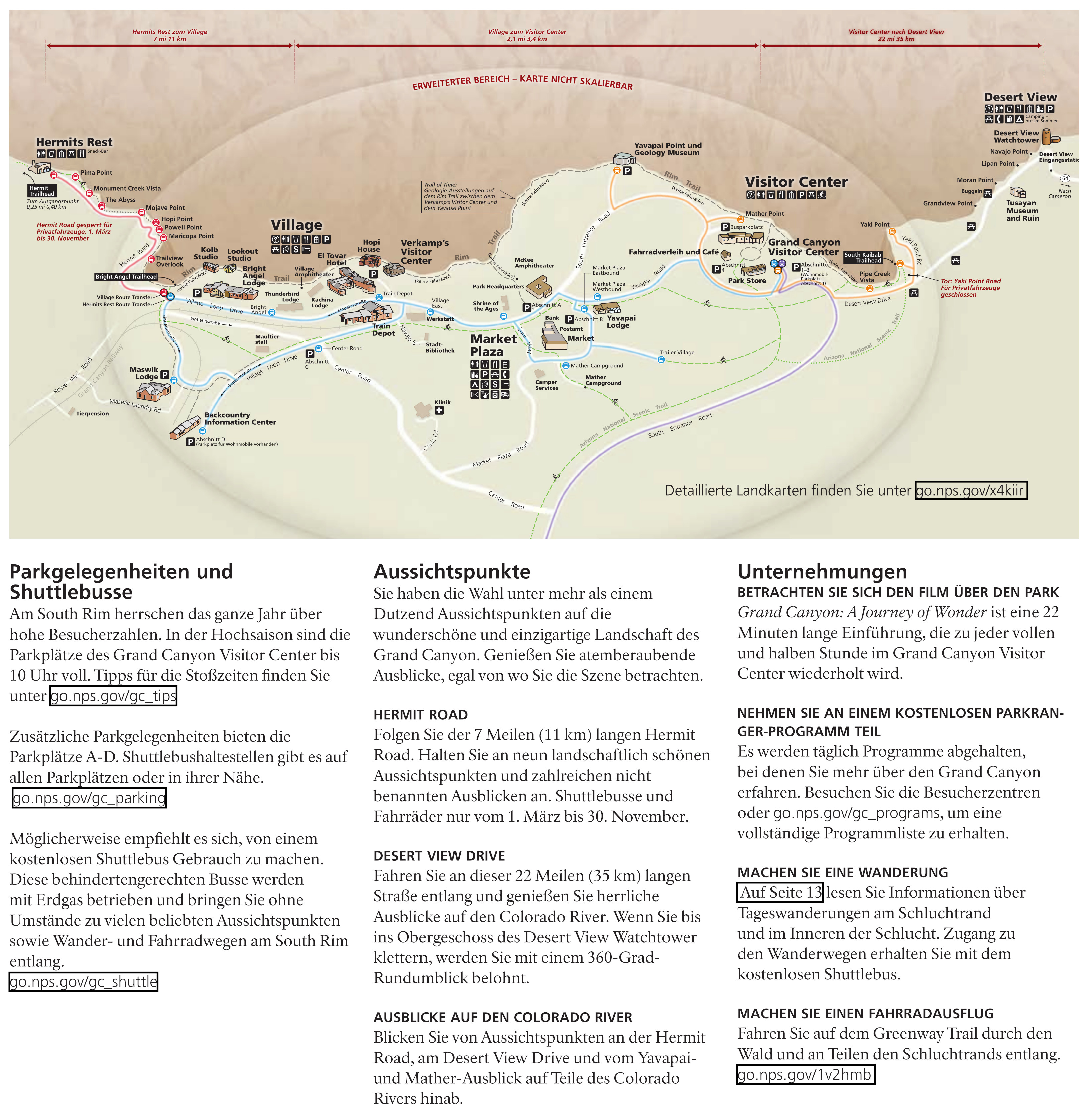
The maps in this section are centered on Grand Canyon Village and show all visitor services and facilities on the South Rim. Note that the maps are not to scale.
- Grand Canyon map in Spanish
- Grand Canyon map in German
- Grand Canyon map in French
- Grand Canyon map in Italian
- Grand Canyon map in Simplified Chinese
- Grand Canyon map in Japanese
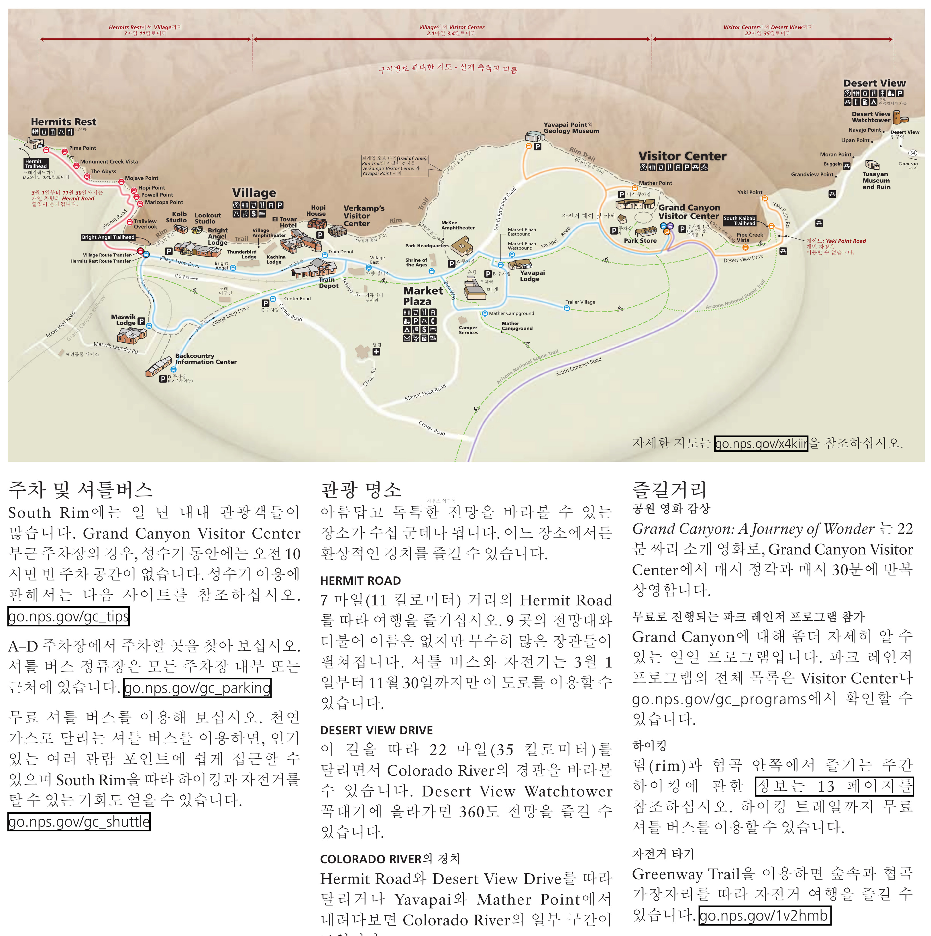
- Grand Canyon map in Korean
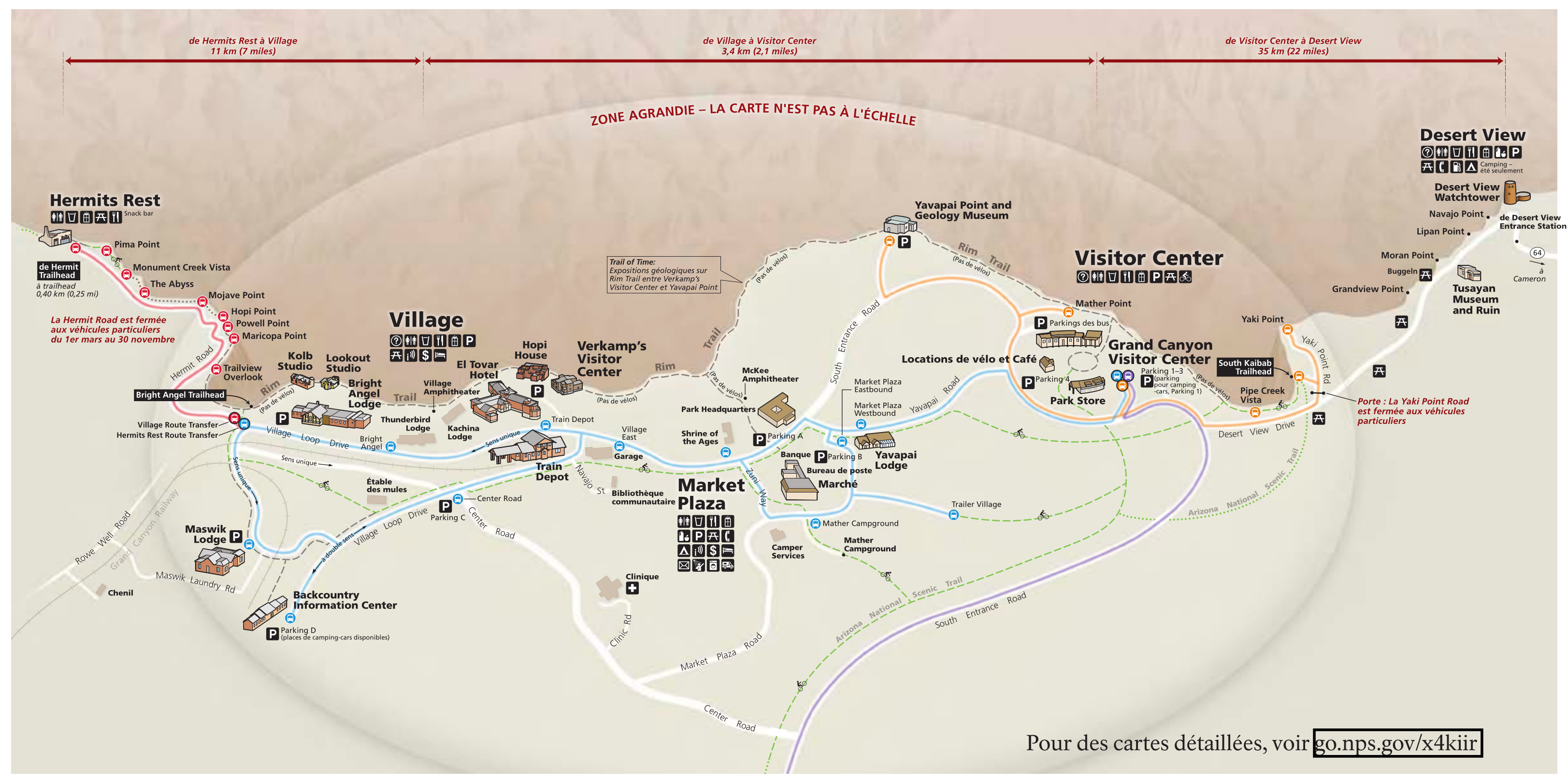
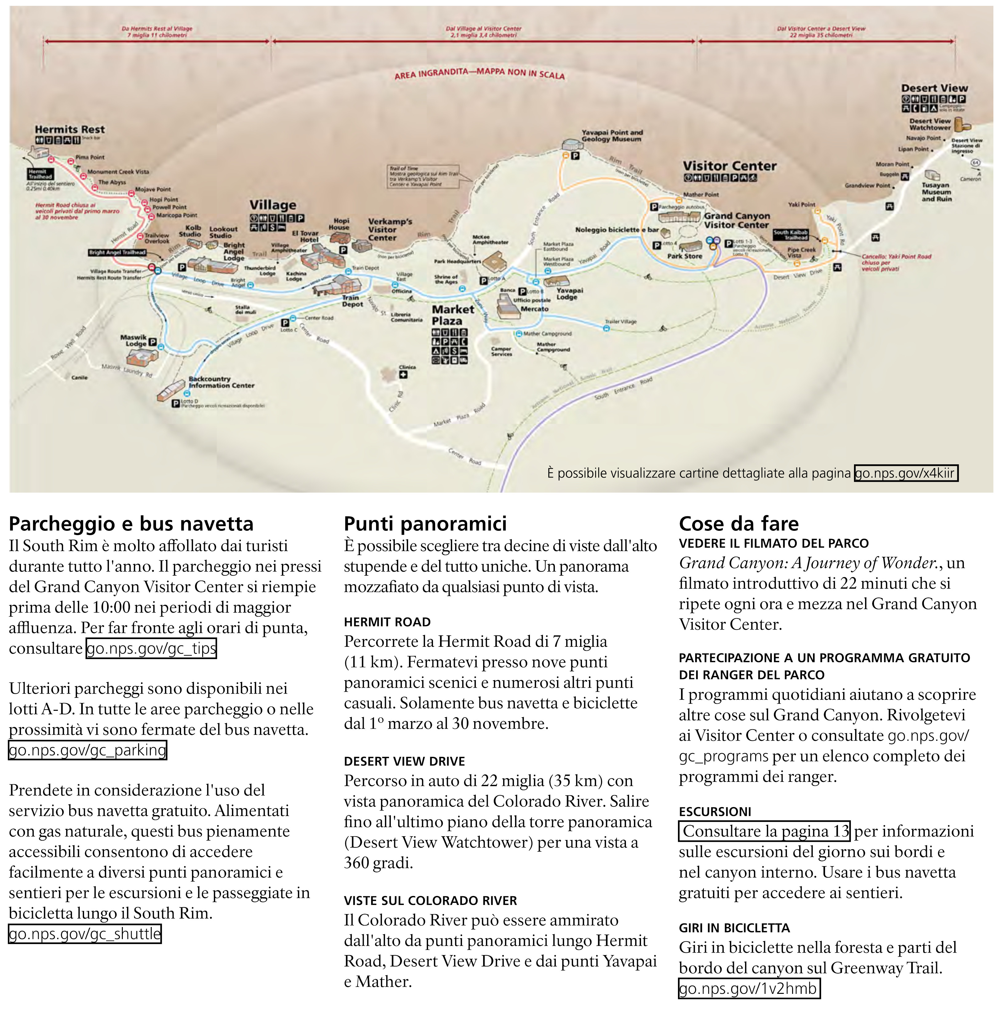
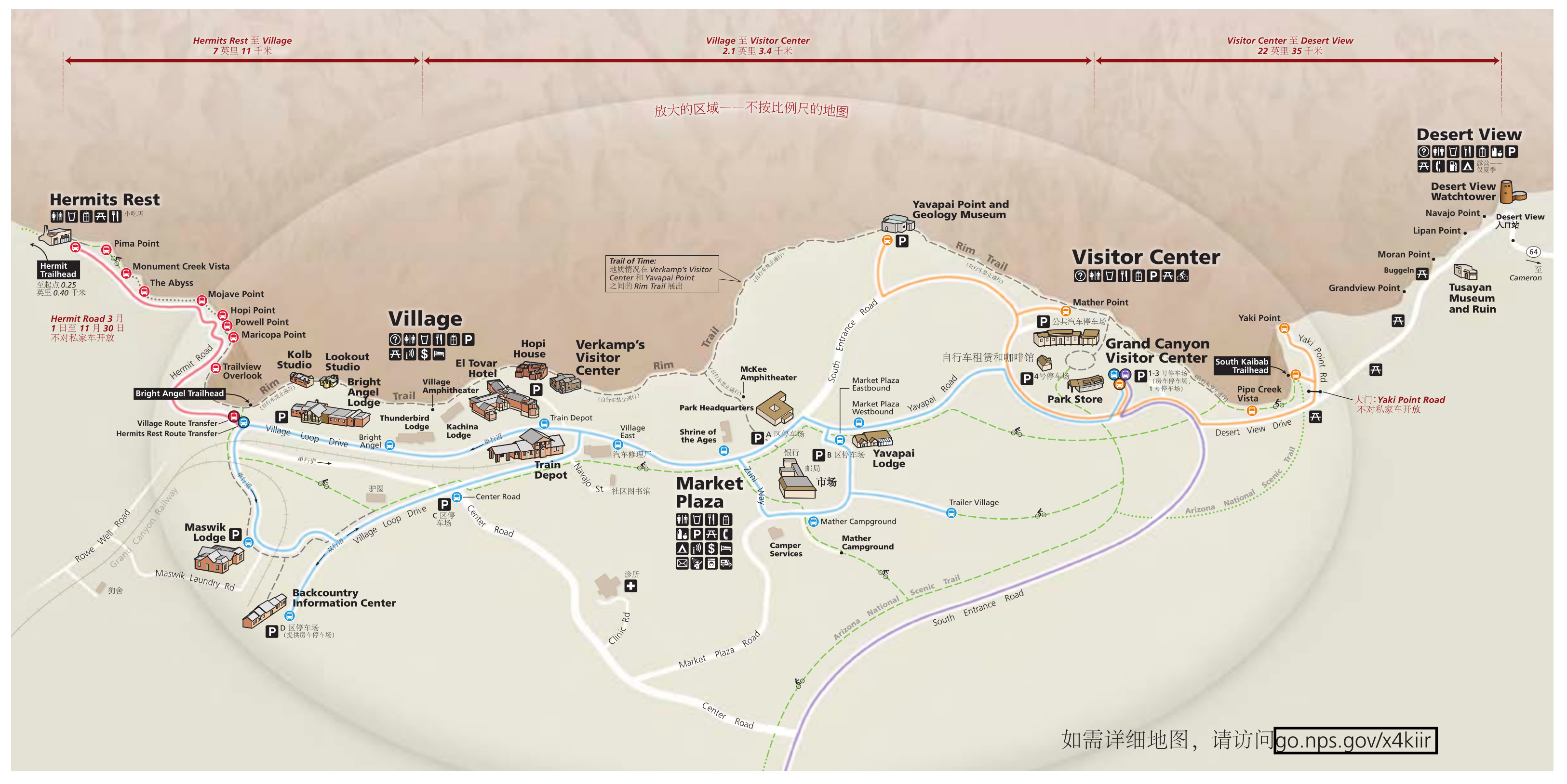
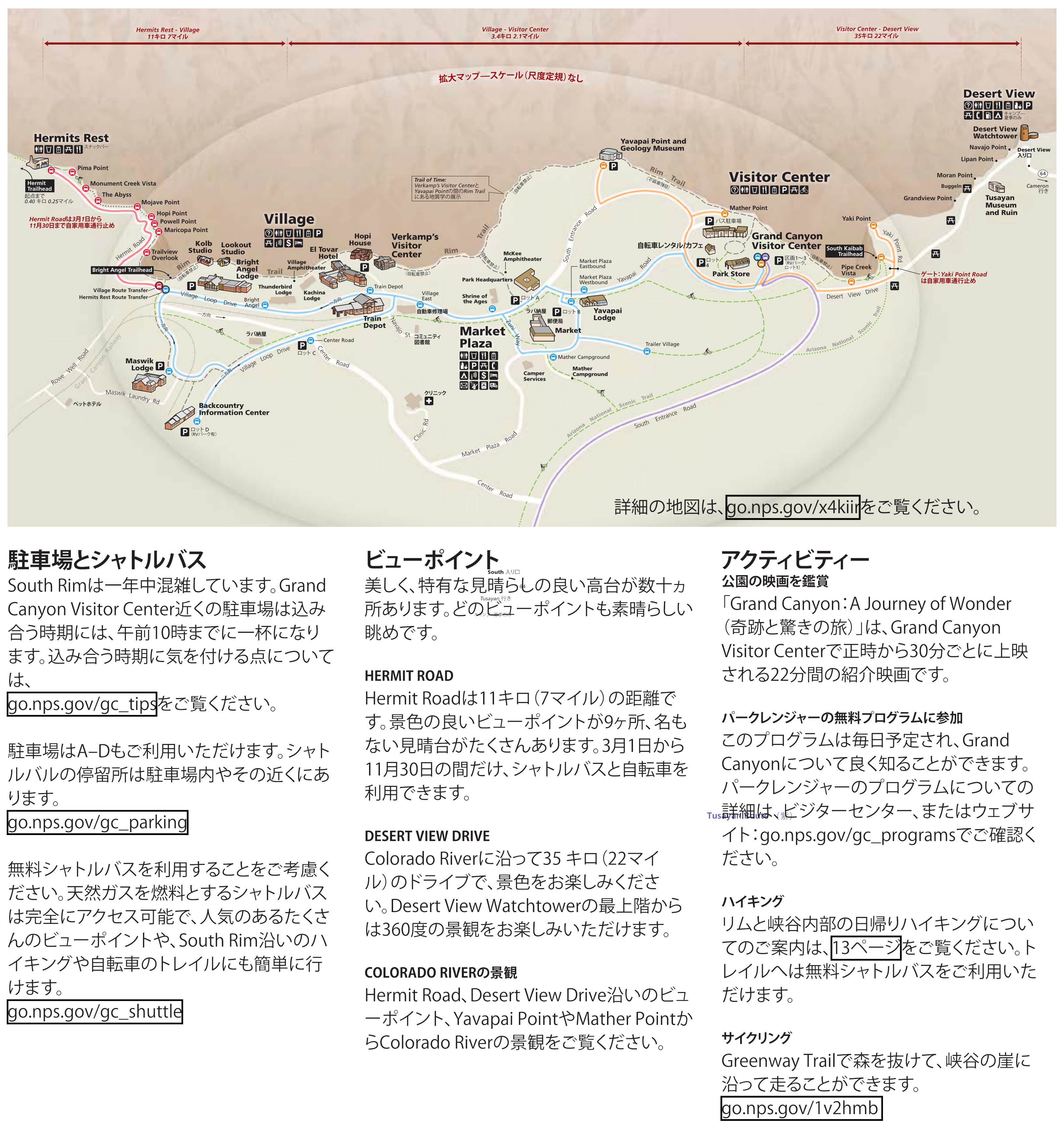
Printable Grand Canyon maps
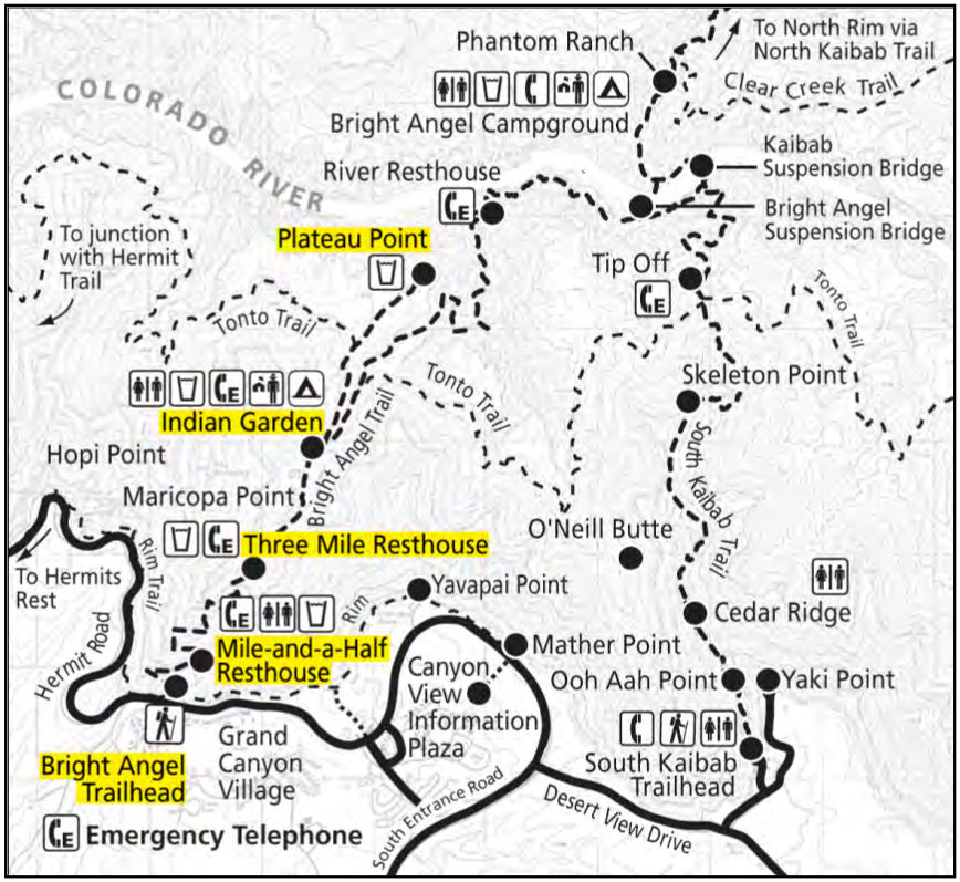 The Bright Angel Trail map highlights the Bright Angel Trailhead and the popular turnaround spots for dayhikes. You can see how it connects to the South Kaibab and Tonto trails.
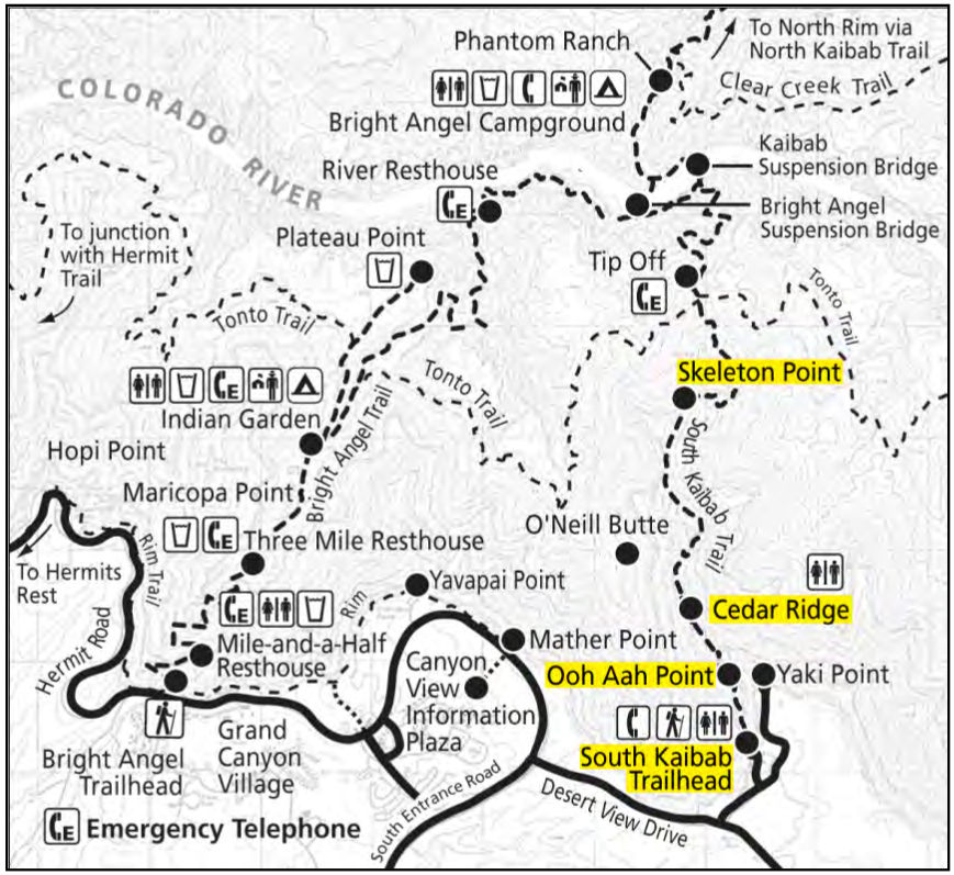 Here’s a South Kaibab trail map, showing the popular day-hike turnaround spots. This is a more scenic descent route to the bottom of the canyon than the Bright Angel Trail, as it follows a spectacular ridge.
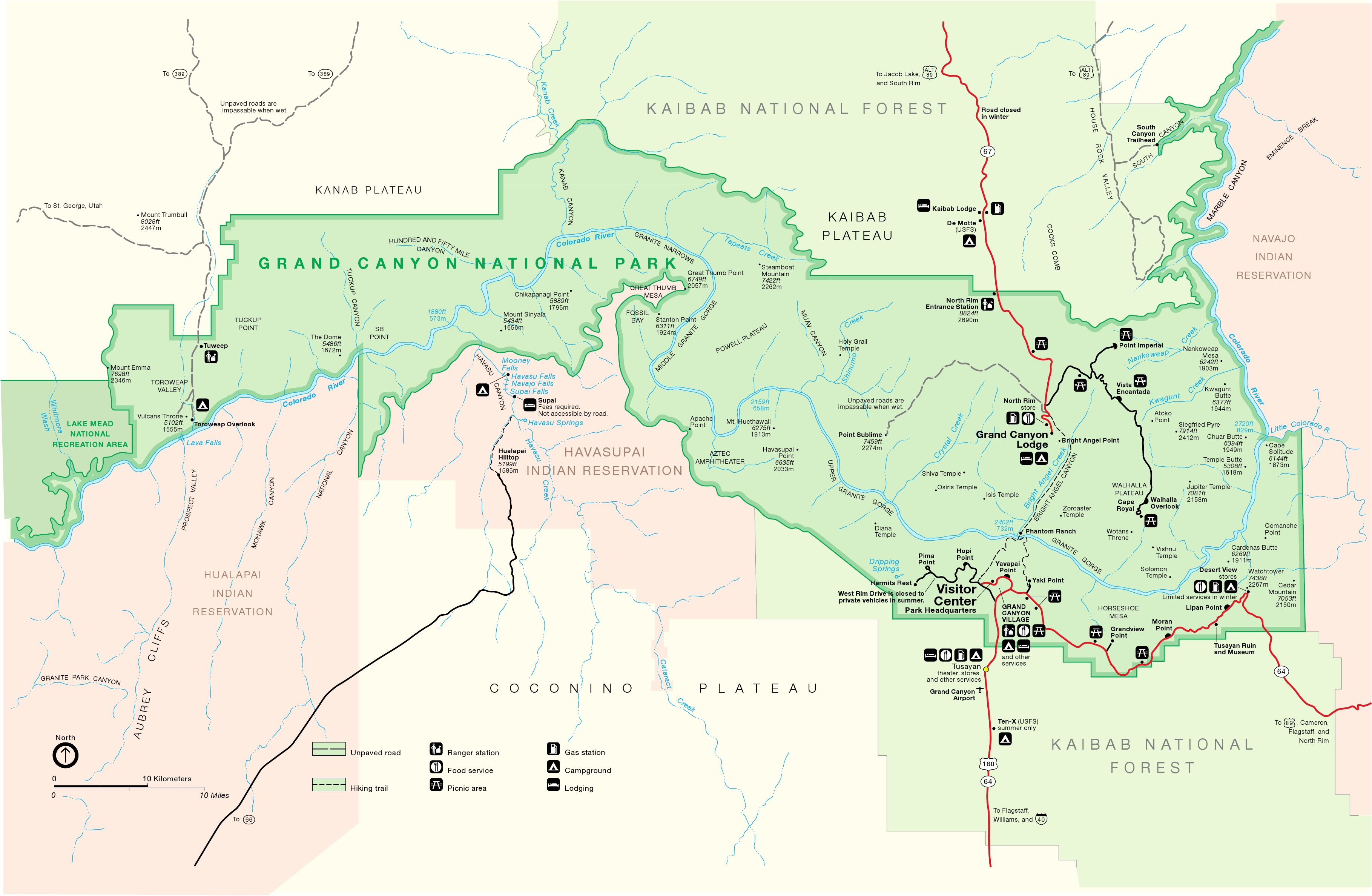 Are you old school? Here is the classic map of Grand Canyon National Park. It may not be pretty, but it is easy-to-read and print. Click the image to view a full size map or download the PDF.
Archived Grand Canyon maps
The National Park Service is frequently updating maps and publishing new ones. I do my best to find new maps and include them on this page, but I never want to delete old maps; I feel they’re important to keep hosting here so we can see how things change in national parks over time. So the maps below all have newer editions shared above.
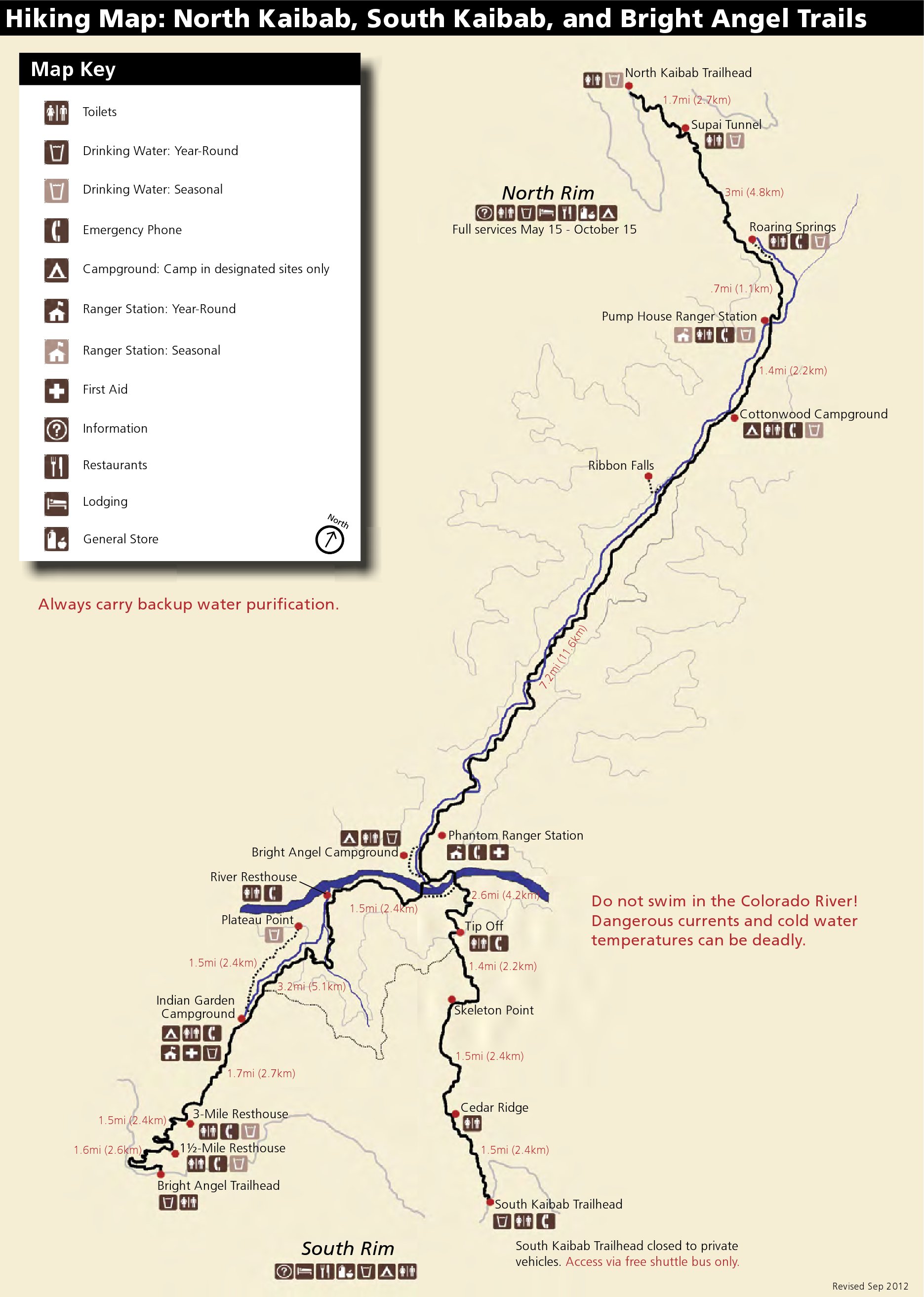 This old Grand Canyon trail map shows Grand Canyon National Park’s three most-used trails: North Kaibab, South Kaibab, and Bright Angel. Click the image to view a full size map or download the PDF.
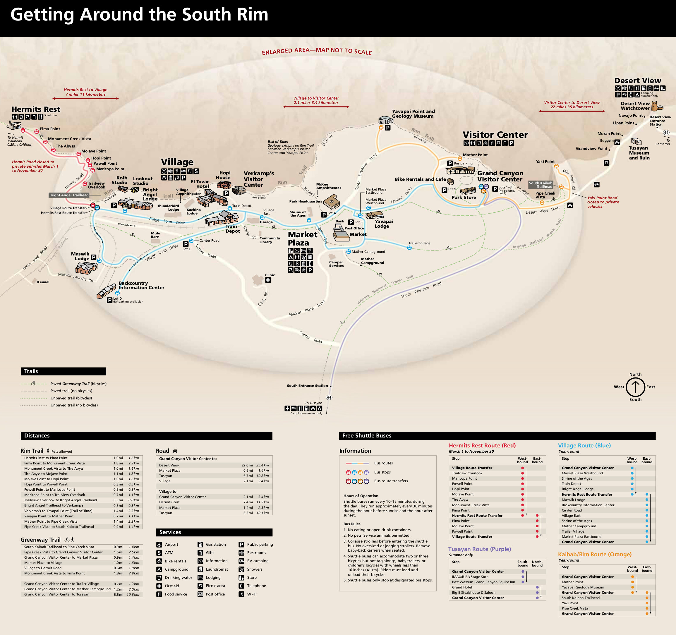 Here’s an old Grand Canyon South Rim pocket map from the late 2010s, showing a simplified map of the South Rim featuring the Grand Canyon lodges, visitor facilities, shuttle bus routes, and points of interest.
 This is the old alternate Grand Canyon shuttle bus map. You can see three routes connecting Hermit’s Rest (west) with Yaki Point (east). Click the image to view a full size map or download the PDF.
 This is the old Desert View Campground map, located near the east entrance on the South Rim and is much smaller than Mather Campground. This is a quieter area of Grand Canyon National Park.
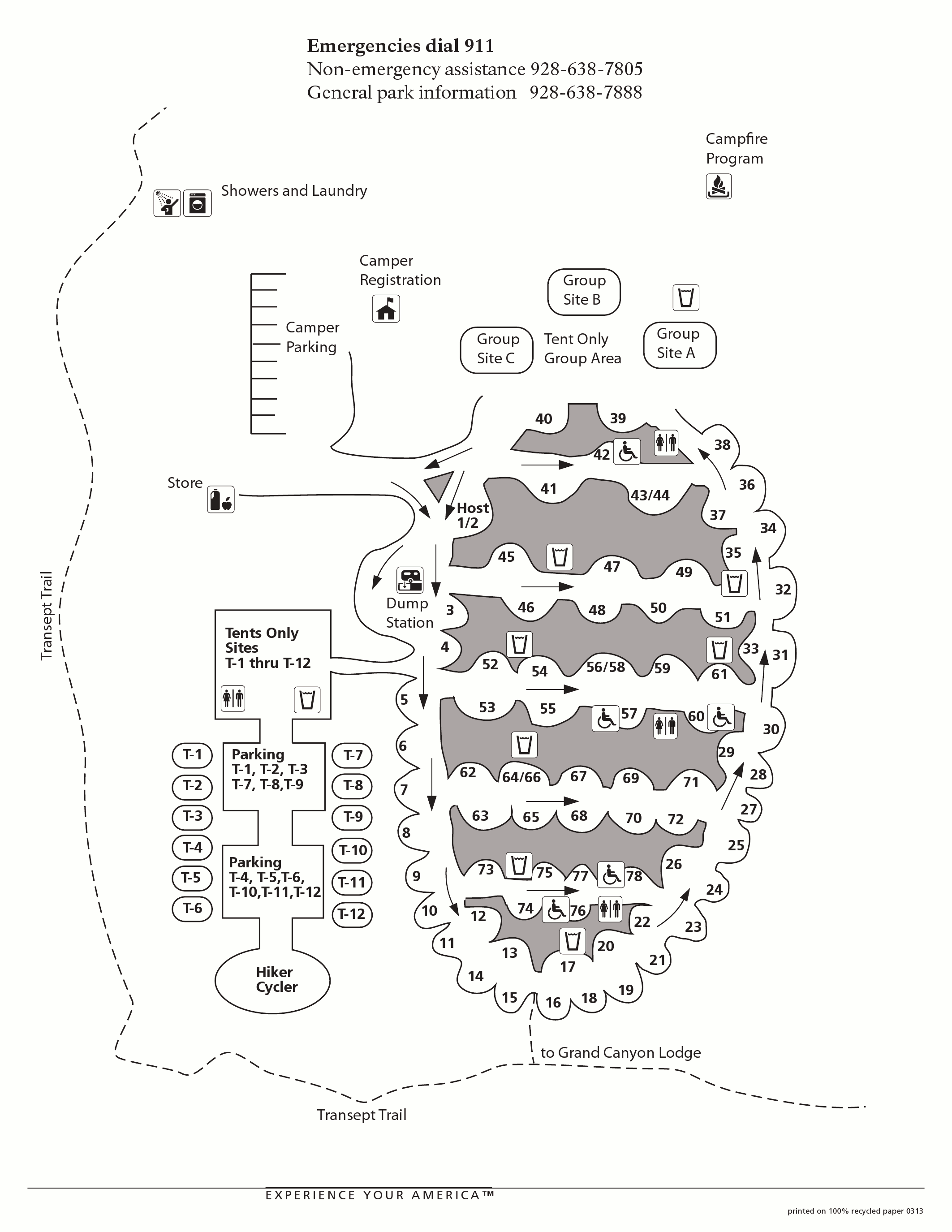 This is the old North Rim Campground map, located at the… well, it’s kind of obvious. This is near the Grand Canyon Lodge and visitor center and is much quieter than anywhere on the South Rim.
Grand Canyon map prints and gifts

 Printed high-resolution Grand Canyon map posters and other products are available at the Grand Canyon Maps store. For art prints, gift ideas, and souvenirs featuring other national parks, support this site and visit the National Park Maps store; you’ll find items to bring on vacation, keep at home for the memories, or give to your park-enthusiast friends and family.
…and more!
< Return to National Park Maps home
< Return to Park List
< Return to List by State