Olympic maps from the park brochure
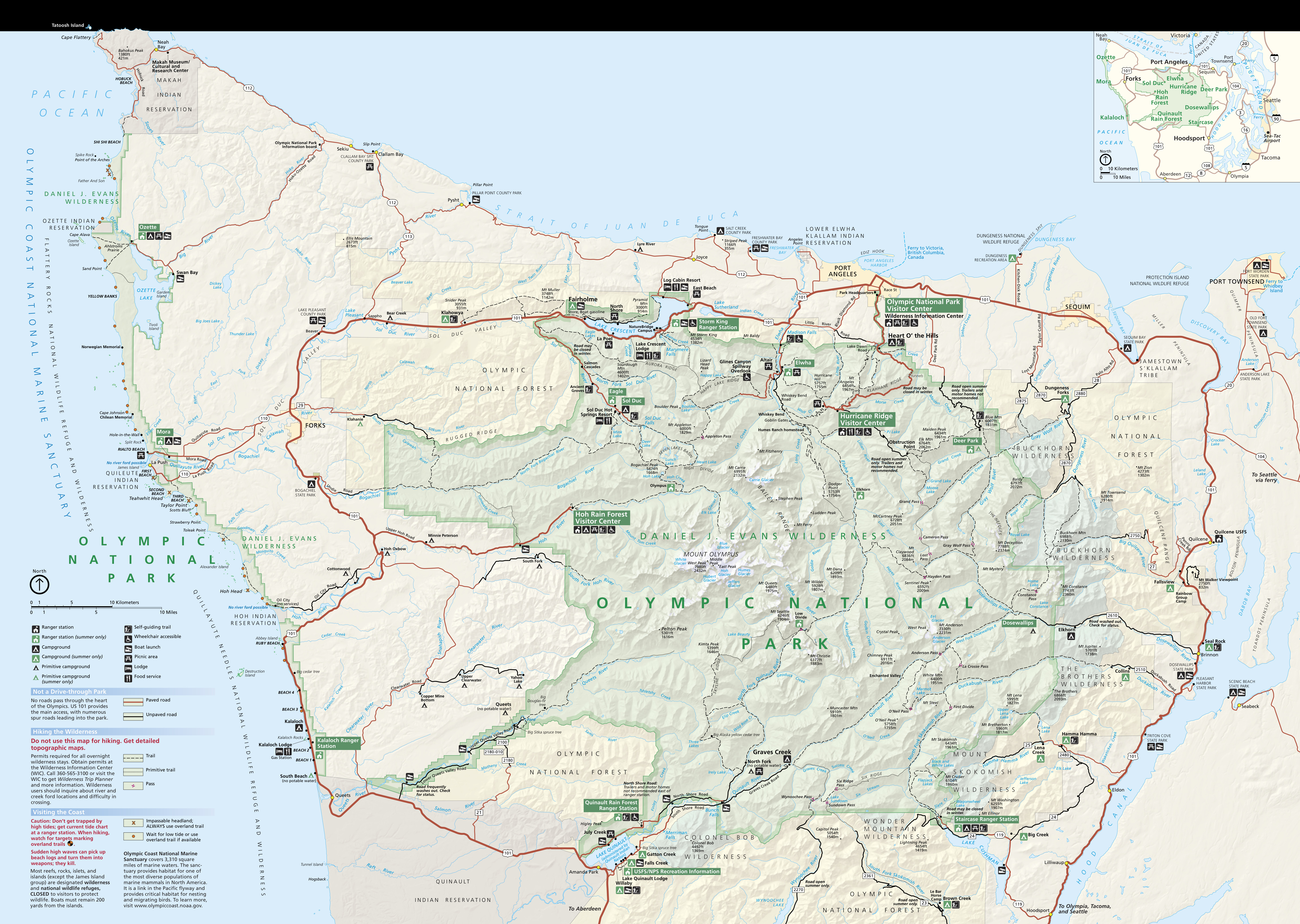 Here’s the official Olympic National Park map from the NPS brochure, last updated in 2021. It’s identical to the one you receive when you visit the park, and includes both the coastal region and Olympic Mountains.
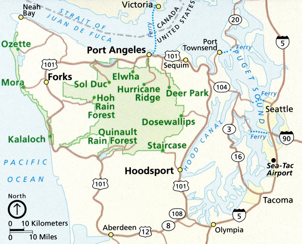 This Olympic regional map shows the surrounding roads and communities and can help you plan your trip logistics (driving directions, lodging, etc.) as you arrive from Seattle or another major town.
Olympic trail maps
 The Olympic wilderness is huge, so if you’re doing overnight backpacking you’ll need something more detailed than the free trail map posted below. The National Geographic Trails Illustrated map covers most of the park in much more detail than you’ll find in the free one. The topographic lines are so key not just for navigation, but also for planning your route, as you need to know whether you’re biting off more than you can chew in a single day.
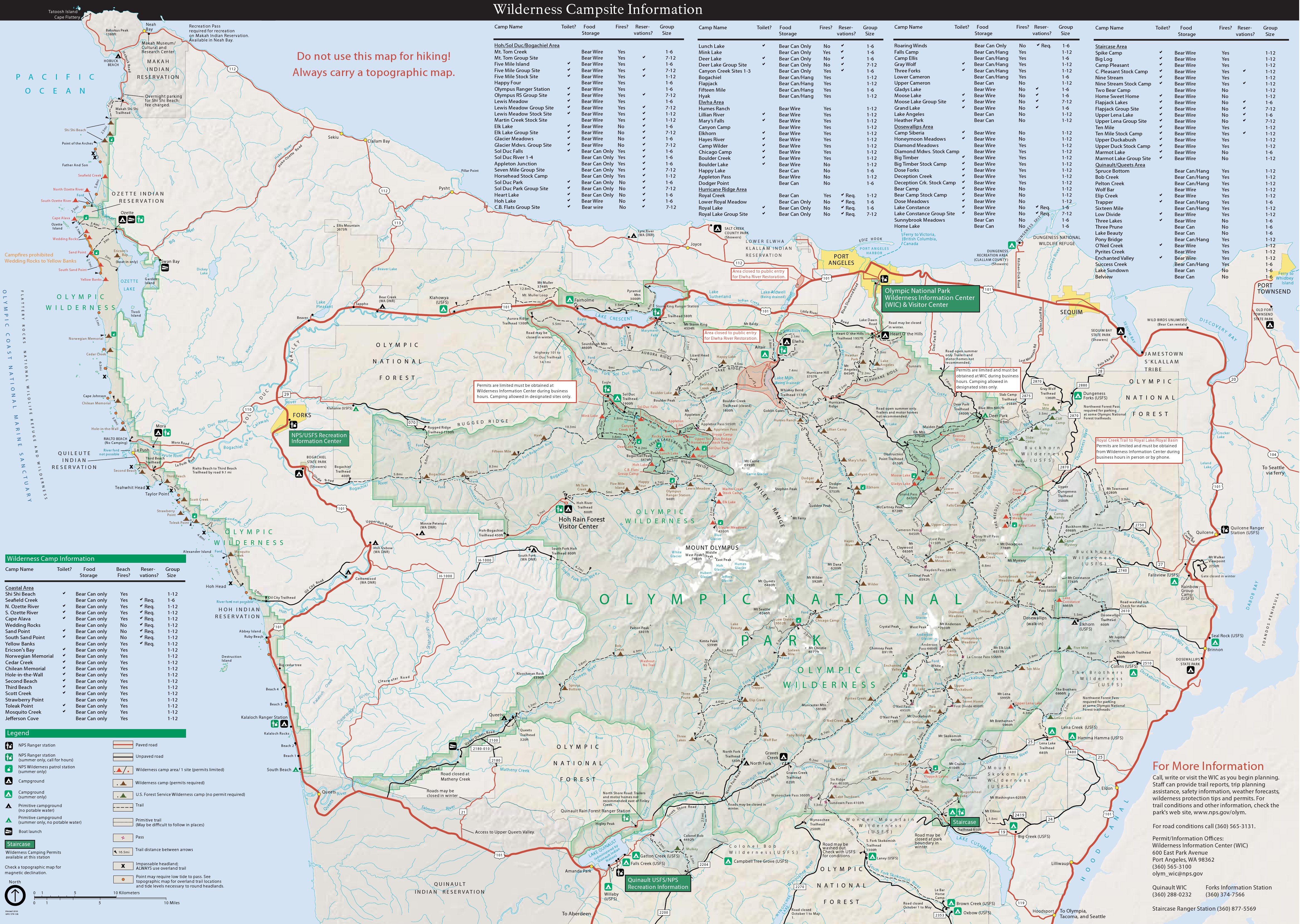
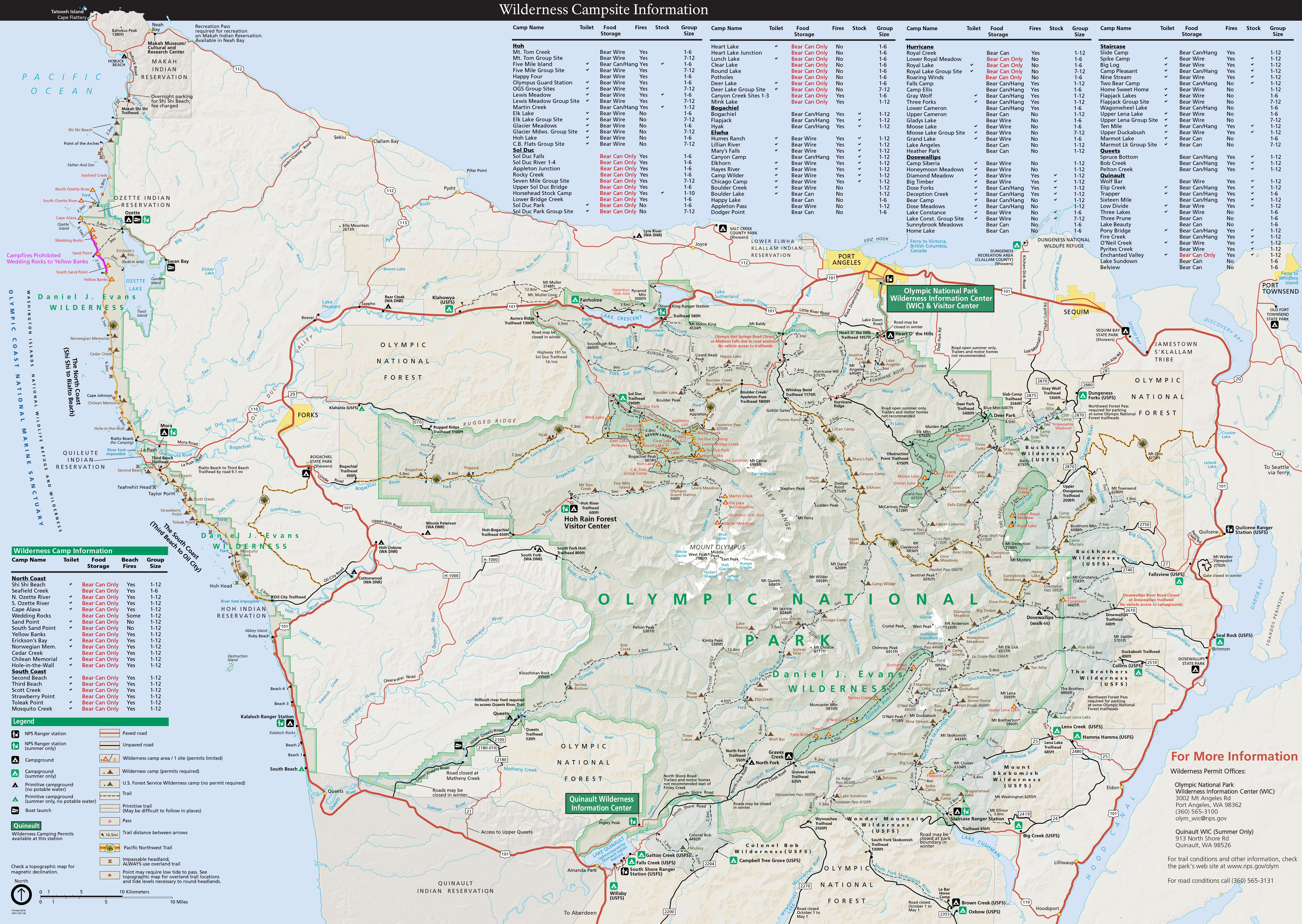 This Olympic National Park trail map is meant to help you plan your trips into the wilderness. All backcountry campsites are labeled, and a table shows you if fires are allowed, if there’s a toilet, and more information.
Hurricane Ridge maps
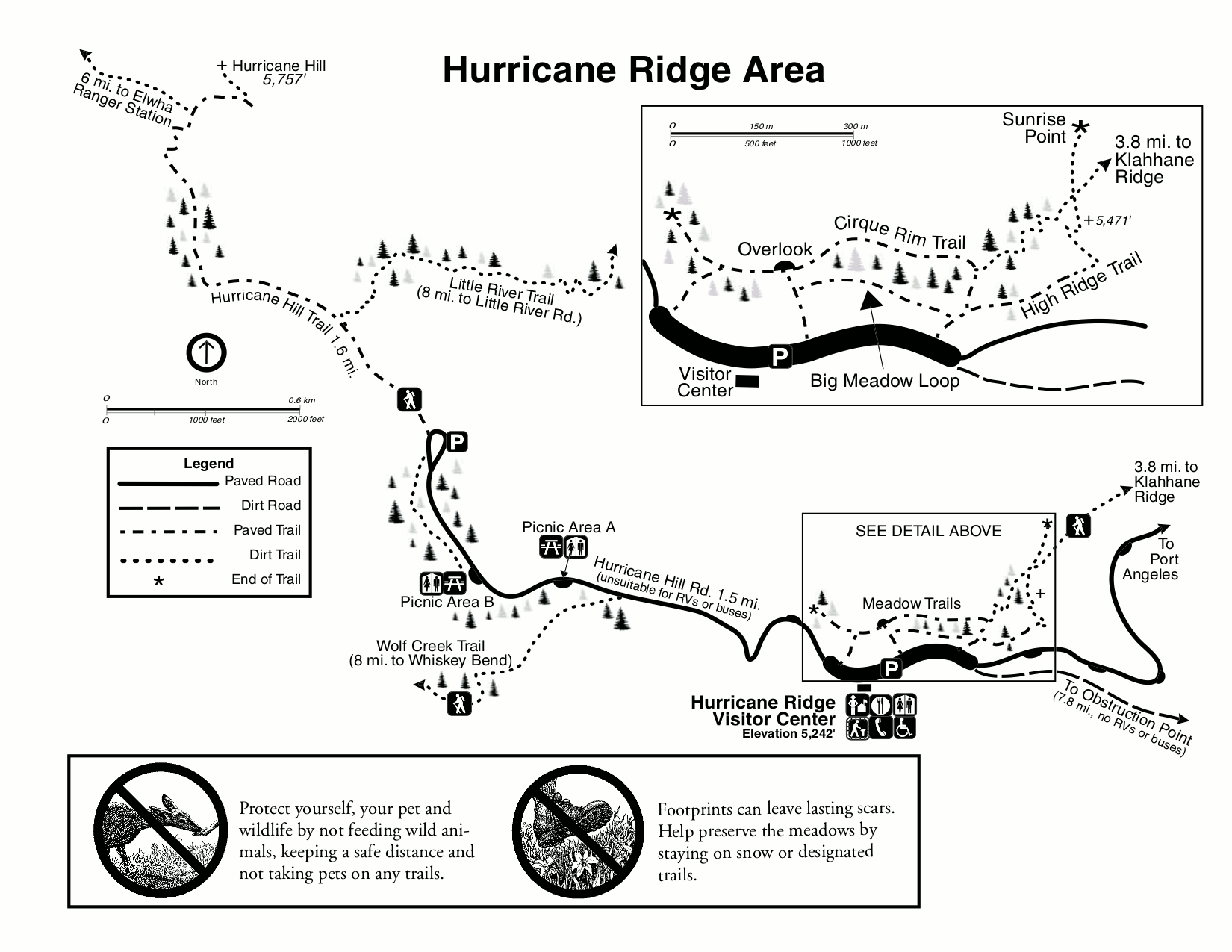 This is a detail map of the Hurricane Ridge area south of Port Angeles, which is one of the most popular destinations in Olympic National Park for its amazing views of Mount Olympus and other mountain peaks.
 Here is a Hurricane Ridge winter map, showing the ski and snowshoe trails, downhill ski area, and winter road closures. It also includes topo lines so you can get a sense for elevation gain on the trails.
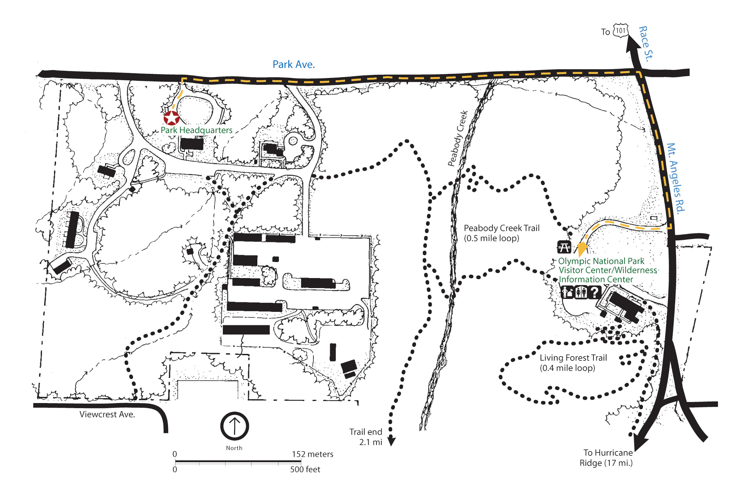 This Olympic Headquarters and Visitor Center map zooms in on the area around the main park visitor center near Port Angeles. It’s on your way to Hurricane Ridge and worth a stop to learn current conditions.
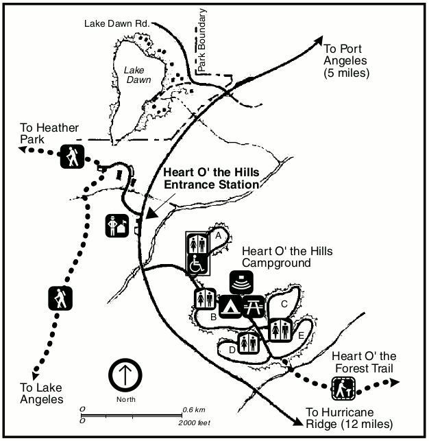 This is the Heart O’ the Hills map, showing the Heart O’ The Hills Campground and hiking trails near the Olympic entrance station, located south of Port Angeles on the way to Hurricane Ridge.
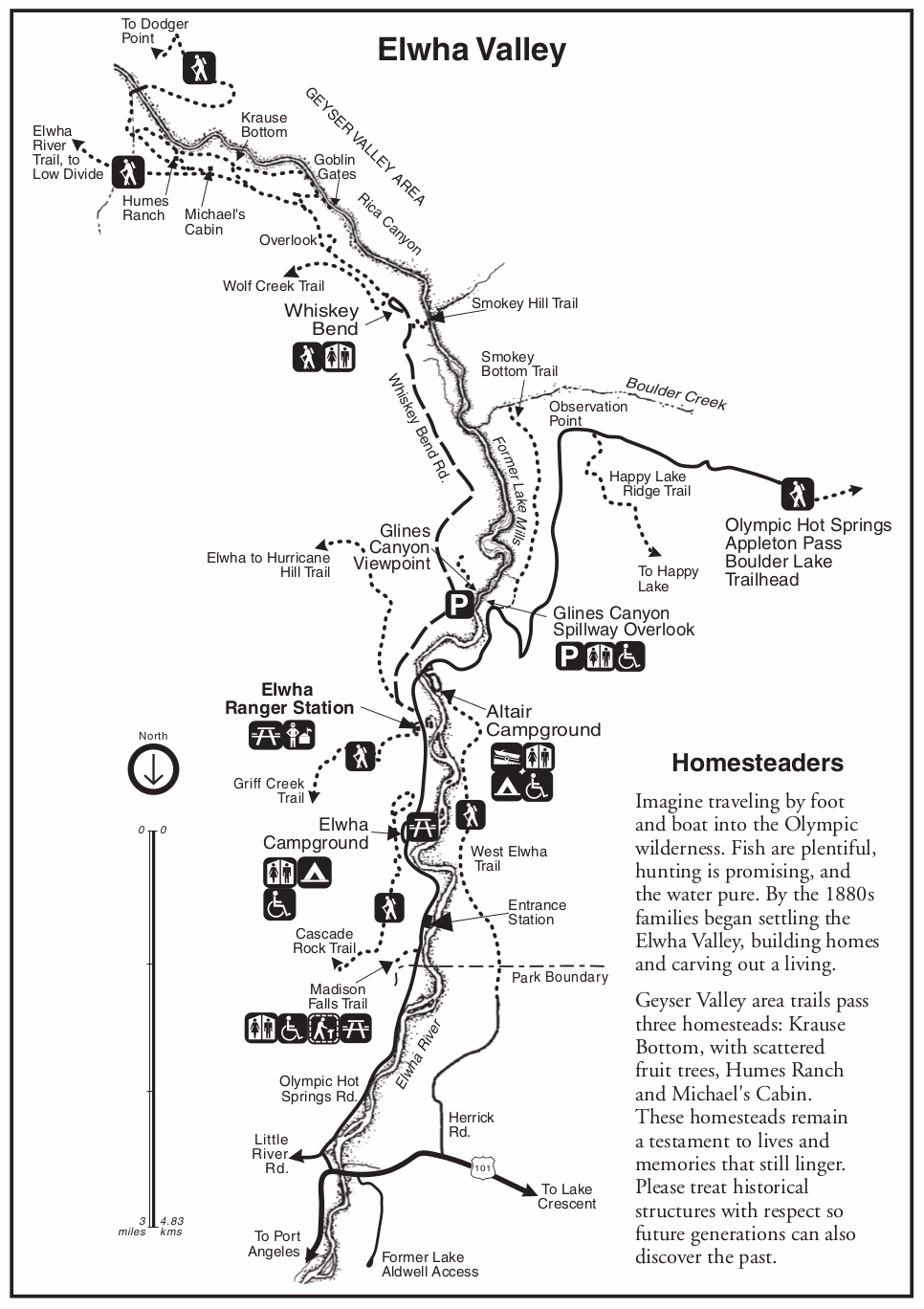
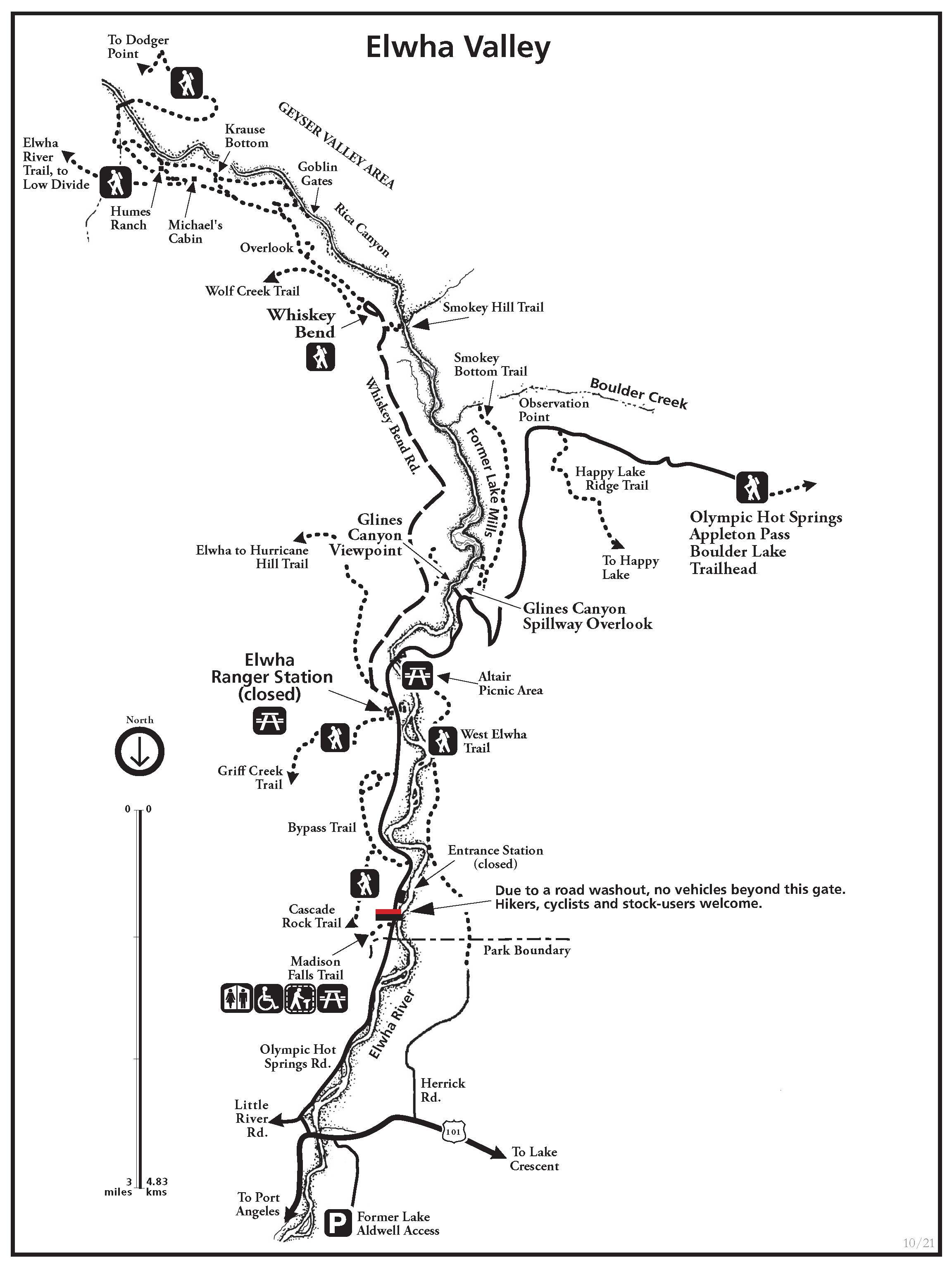 Here is an Elwha River map, last updated in 2021. This area is located west of Hurricane Ridge through a separate access road. Much of this area may be inaccessible due to road closures from flood damage; inquire at the park.
Olympic lodging map
 Many Olympic visitors stay north of the park, especially near Port Angeles; to the right you’ll find an Expedia interactive lodging map centered there. It’s a convenient area for visiting Hurricane Ridge and other northern Olympic sights; you can view the top-rated Olympic lodging options there. If you’re more interested in visiting the Hoh Rain Forest and the coast, instead browse the best-rated lodging near Forks.
Olympic rainforest maps
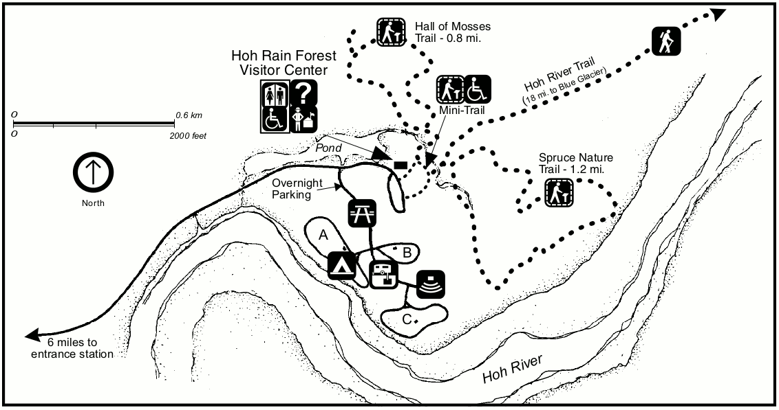 This Hoh Rainforest detail map shows the Hoh Rain Forest Visitor Center, trails, campground, and points of interest along the Hoh River in western Olympic National Park.
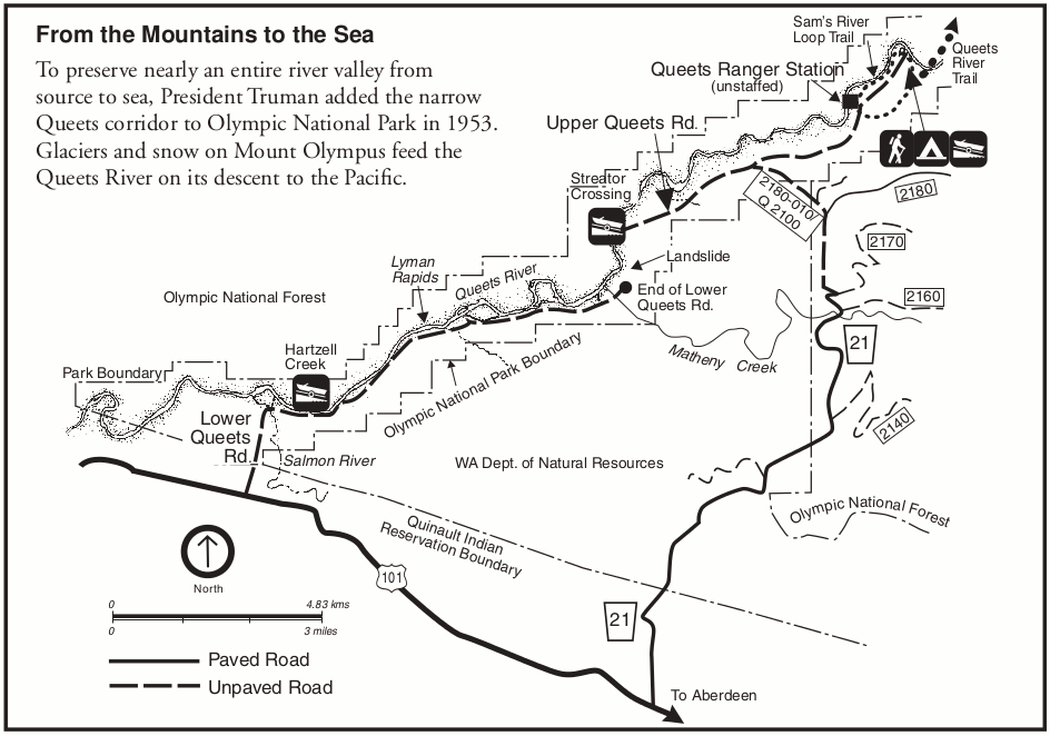 This is a map of the Queets area in southwest Olympic National Park, showing the road, trails, camping, and points of interest along the Queets River in this quiet part of Olympic.
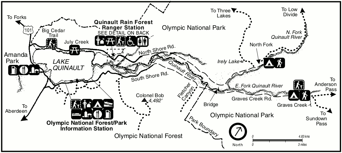 This is a Quinault Rain Forest area map in southwest Olympic, showing the campgrounds, hiking trails, and visitor centers near the Quinault River and Lake Quinault.
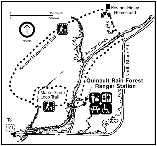 This map shows the Quinault Ranger Station detail, described as “see detail on back” in the map above. Here you’ll find a couple trails nearby Kestner Creek.
Olympic Coast maps
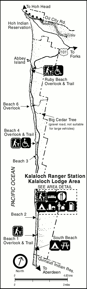 This is a detail map of the Kalaloch area, showing beach and ocean access (including Ruby Beach) where US 101 parallels the coast in Olympic National Park. See the map below for detail around the lodge.
 This is the inset map of Kalaloch covering the area shown as “see area detail” on the map above (Kalaloch Campground, Kalaloch Lodge, and the ranger station and hiking trails).
 This map shows the Mora area, including Rialto Beach, La Push, and the various resorts, roads, and trails on this section of Pacific coast a bit further north than Kalaloch in Olympic National Park.
 This is a zoom in on the “see detail on back” described in the previous map, showing the Mora campground, ranger station, and trails to the beach, James Pond, and the Slough Trail.
 This is a detail map of the Ozette area on the Olympic coast. It shows Ozette Lake, Ozette Ranger Station, and the trails, roads, and points of interest nearby such as Cape Alava and Sand Point.
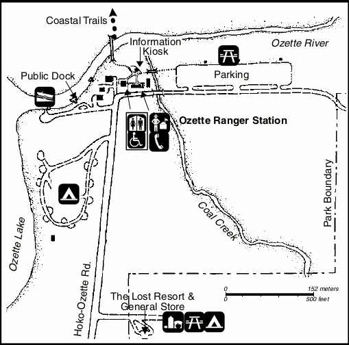 This is an inset map of the Ozette Ranger Station, referenced as “see details on back” in the Ozette map above and showing the campground, parking, trails, and stores.
 Here is a Cape Alava camping map, showing the designated camping areas along the beach (individual sites and group sites) and outhouses. This is accessed from Lake Ozette.
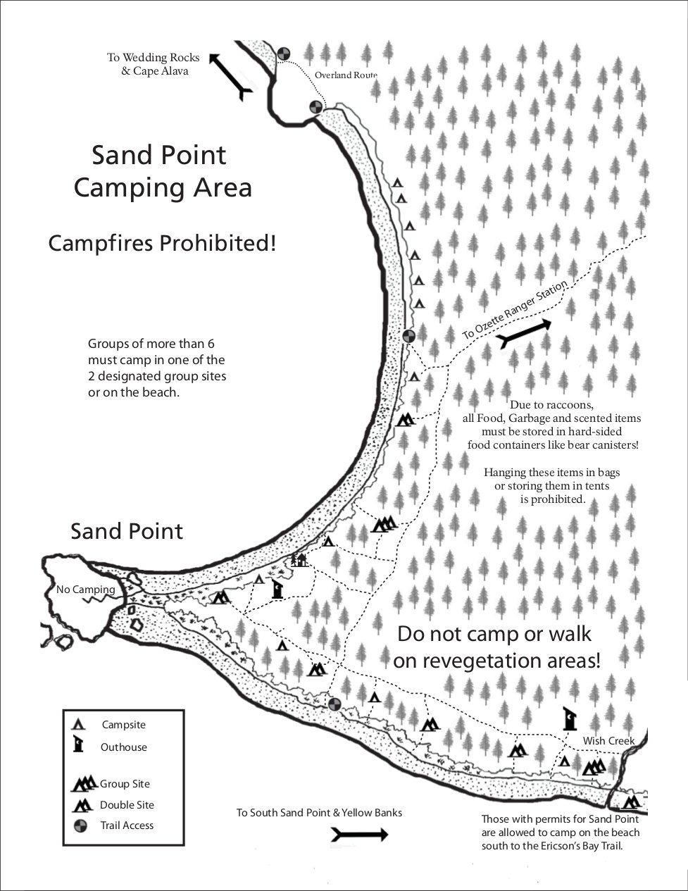 Here is a Sand Point camping map, showing legal camping areas around Sand Point, located south of Cape Alava. This map also shows the size of each campsite and locations of outhouses.
Lake Crescent maps
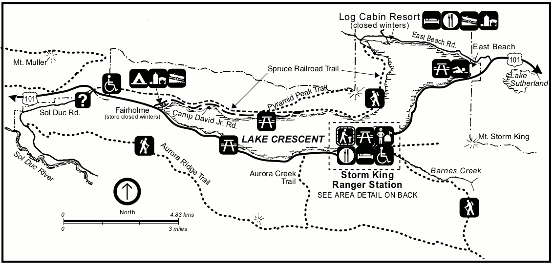 This map of the Lake Crescent area shows the points of interest in the northern part of Olympic National Park where US 101 parallels Lake Crescent: picnic areas, hiking trails, camping, and so on.
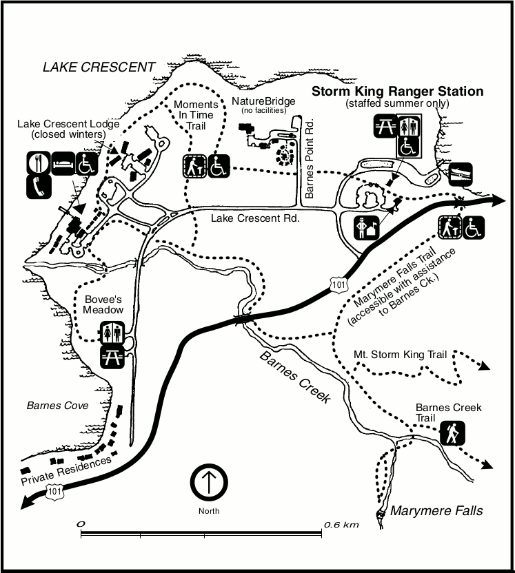 This is the inset map showing the south shore of Lake Crescent; this covers the area shown as “see area detail on back” in the map above, including the Storm King Ranger Station and vicinity.
Sol Duc maps
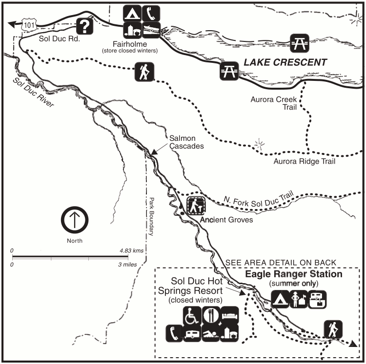 The Sol Duc area map is in the northwest part of Olympic National Park. This map shows the Sol Duc Road (leading to the Sol Duc Hot Springs Resort) and trails and points of interest along the way.
 This is the inset map of Sol Duc labeled as”see area detail on back” in the previous map. It shows Sol Duc Falls, the resort, Eagle Ranger Station, and trails leading to Sol Duc Park, Deer Lake, and more.
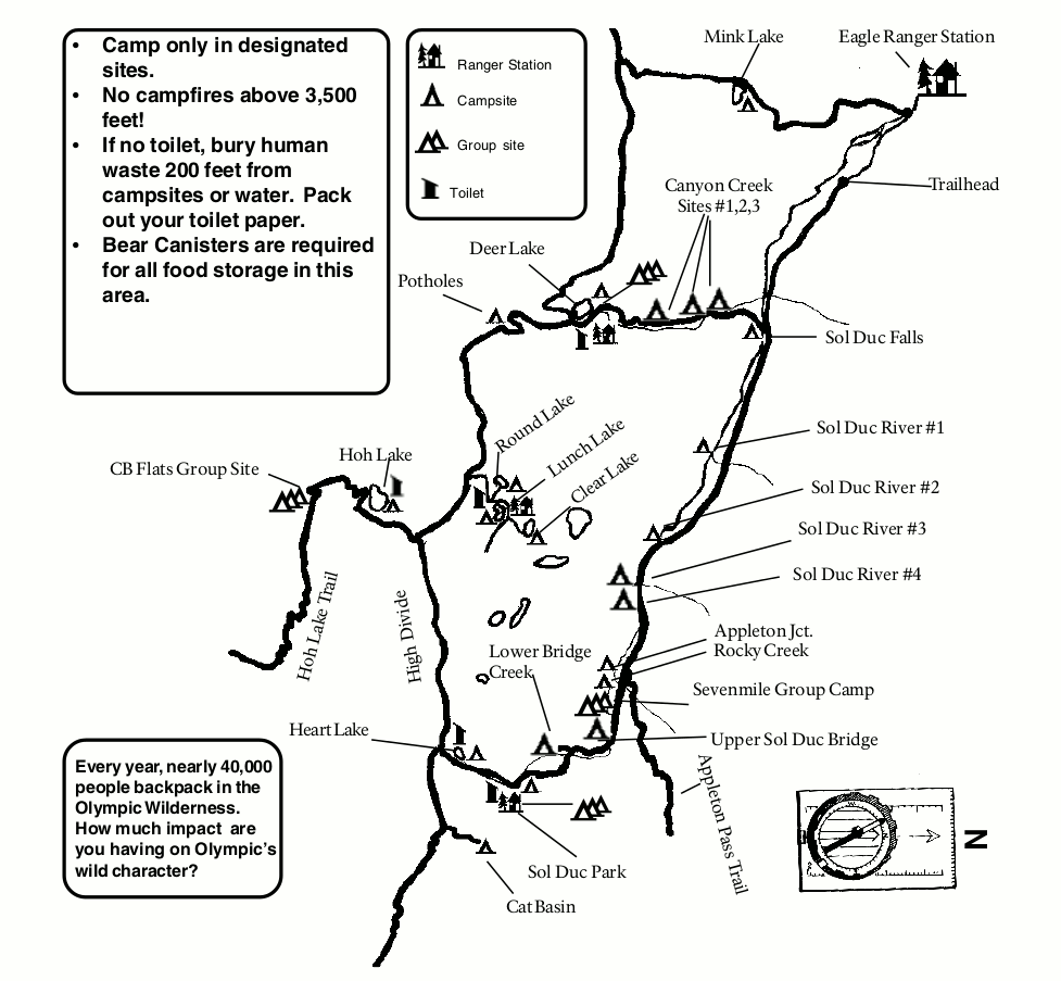 Here is a Seven Lakes Loop map – a very popular backpacking route into Seven Lakes Basin accessed from Sol Duc. This map shows both individual backcountry campsites as well as group sites.
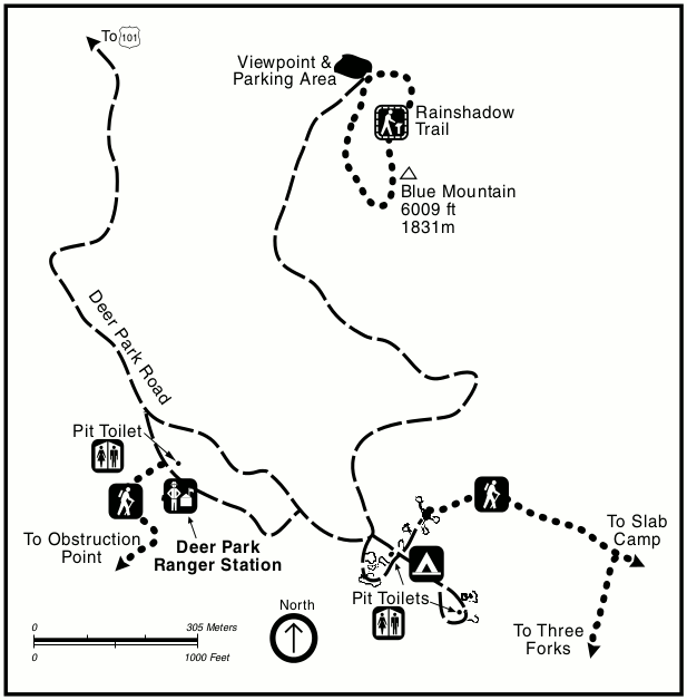 This is a detail map of the Deer Park area in the northeast corner of Olympic National Park, showing the trails, roads, parking, viewpoints, toilets, and the Deer Park Ranger Station.
Staircase maps
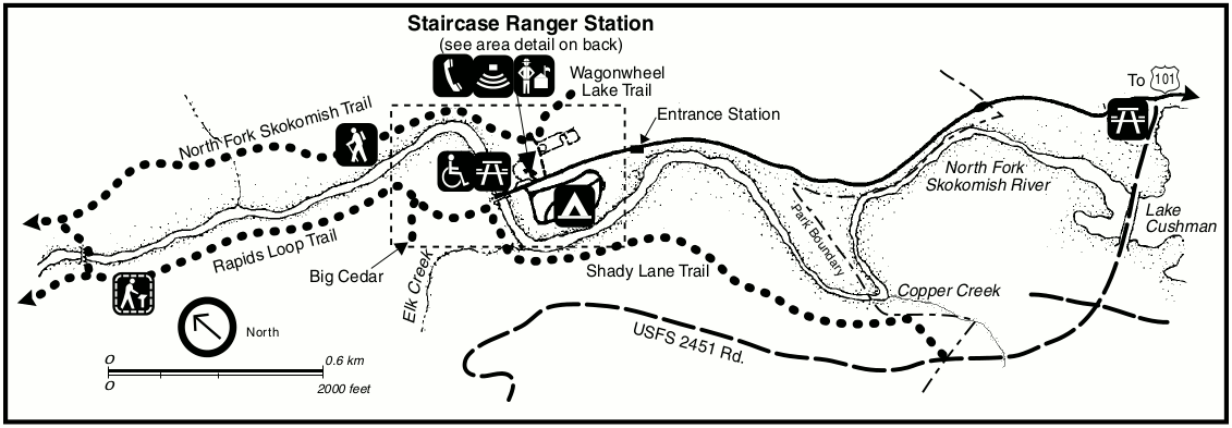 This is a detail map of the Staircase area in the southeast corner of Olympic National Park. It shows the trails, campground, ranger station, roads, and picnic areas.
 This map zooms in on the Staircase Ranger Station where it says “see area detail on back” on the map above. You can see the campground layout, parking areas, and trail details.
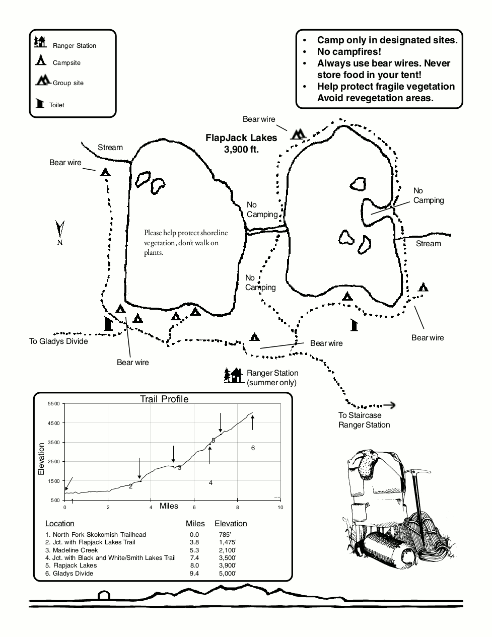 Here is a Flapjack Lakes camping map, showing the designated camping areas, outhouses, and bear wires near Flapjack Lakes, accessed from the Staircase area.
Assorted Olympic maps
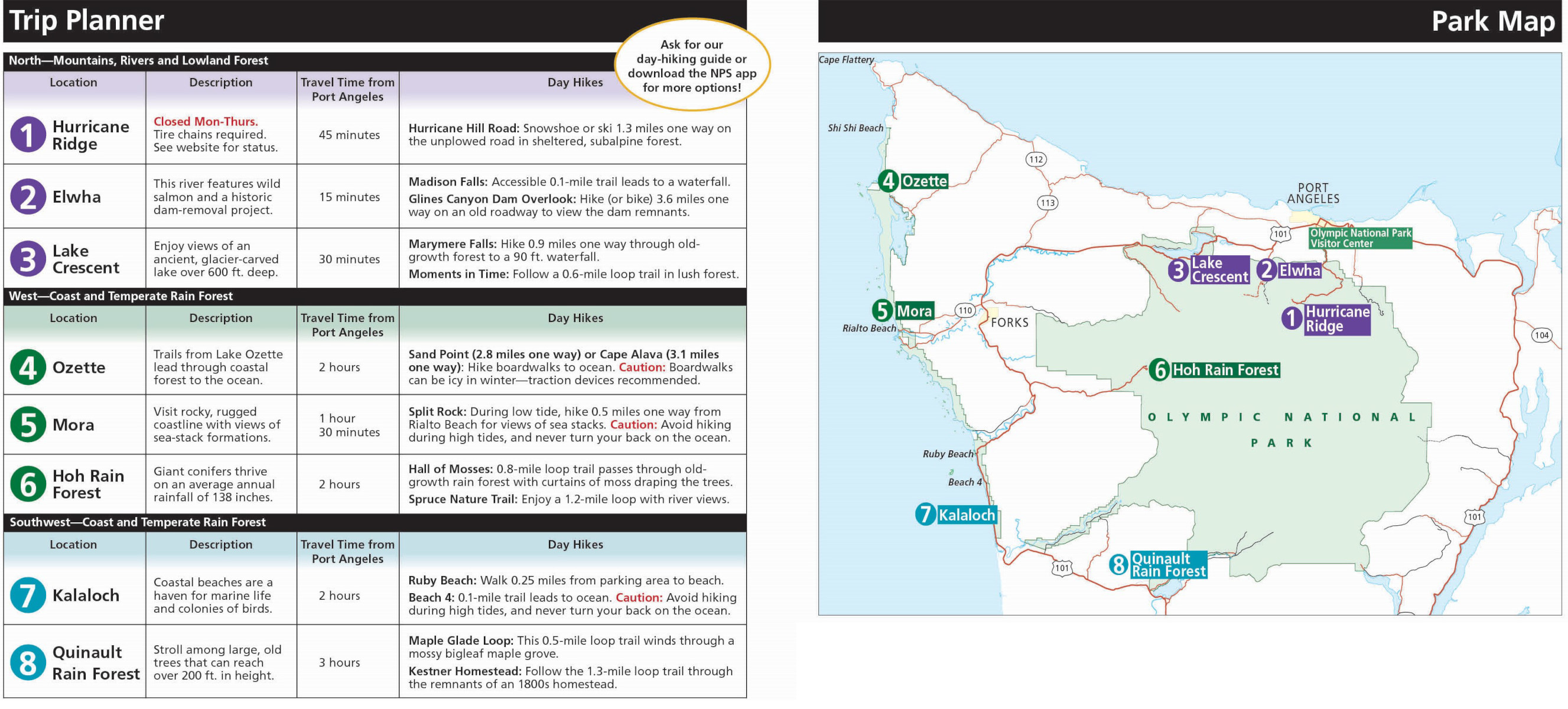
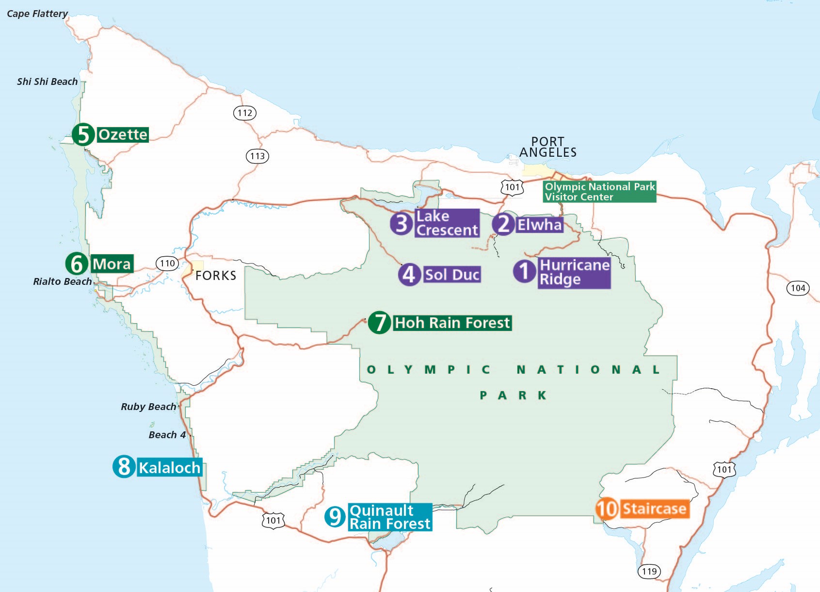 This Olympic attractions map is very simplified to easily show the main 10 areas to visit. Locations are color-coded to help plan your visit, as generally each color can be combined into a day. (Purple might need two days.)
 Here’s a simple winter map of Olympic National Park. It’s much like the map above but shows the areas accessible during the winter wet and snowy winter months. A handy table is provided to include travel times.
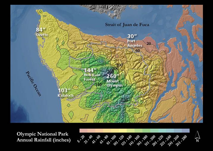 The Olympic Peninsula precipitation map perfectly illustrates the concept of the rain shadow effect: Note how wet the coastal region is compared to Port Angeles and the leeward side of the mountains.
 Here’s an Olympic fire history map, showing the location and size of fires in recent human history. Note how most are on the east side of the park, which receives much less rain than the west side.
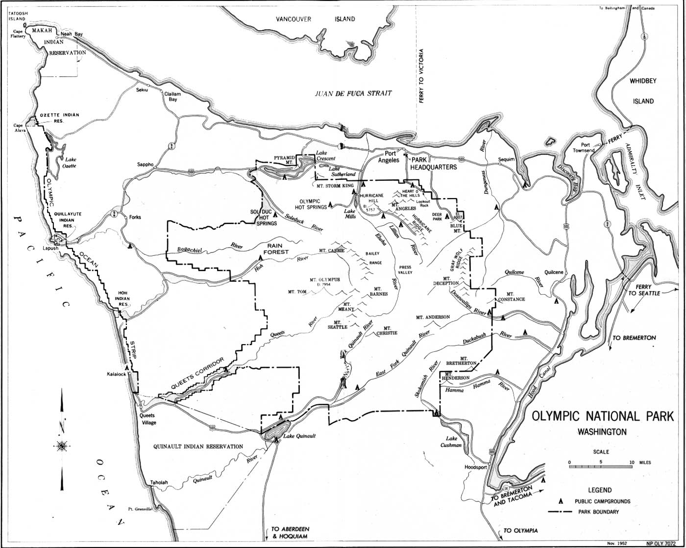 This Olympic historical map shows the park in 1952. Note certain roads that no longer exist, and roads that have since been built (Hurricane Ridge has one of each).
Archived Olympic maps
The National Park Service frequently updates maps and releases new ones, and I do my best to upload them here as I come across them. But I try to avoid removing old maps; I believe it’s important to tell the story of how national parks change over time. So in this section, you’ll find maps that have since been superseded by ones above.
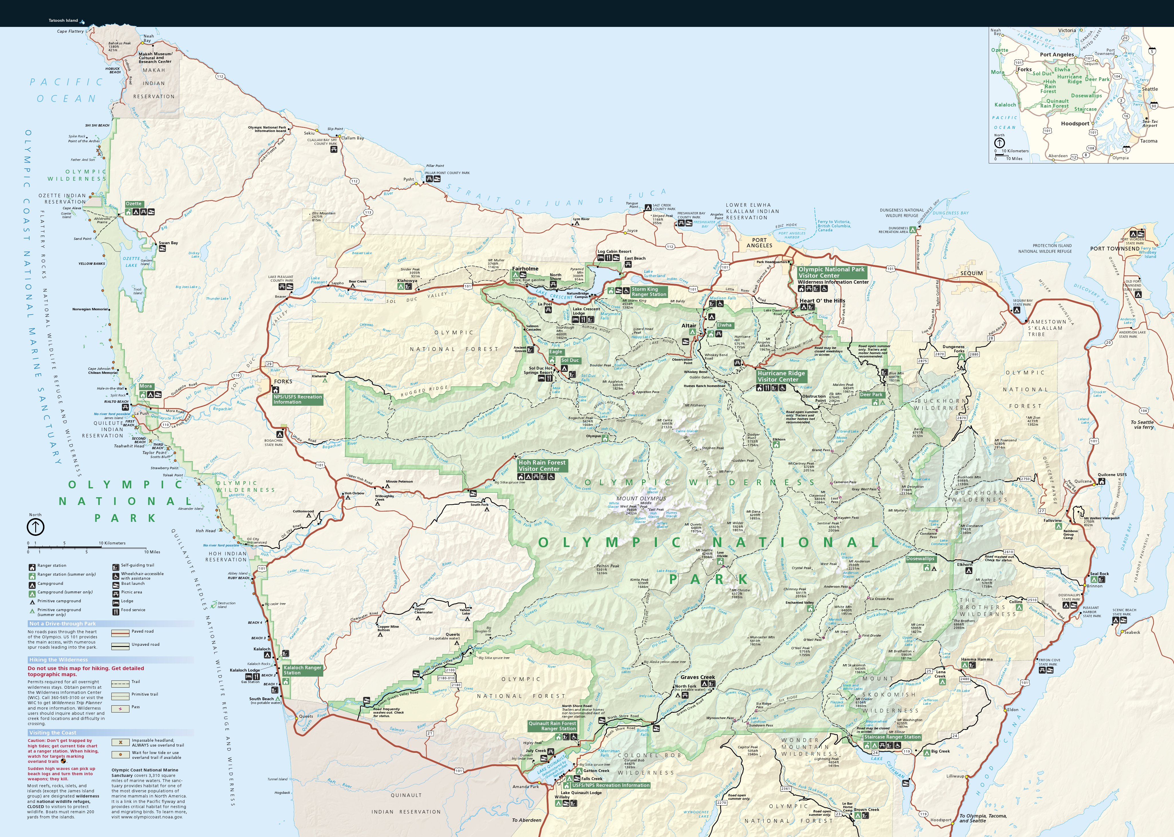 This is the main Olympic National Park map from the mid-2010s, showing roads, trails, campgrounds, rivers, peaks, and visitor services. Click the image to view a full size map or download the PDF.
 This is an old Olympic wilderness map showing trails and designated wilderness campsites in the backcountry. This map dates from about 2010. Click the image to view a full size map or download the PDF.
 Here is an old Elwha River map, showing former facilities and campgrounds located along the river, including the former dam sites. The campgrounds here are now closed and have been converted to picnic areas.
Olympic map prints and gifts

 Printed high-resolution Olympic map posters and other products are available at the Olympic Maps store. For prints, gift ideas, and souvenirs featuring other national parks, support this site and visit the National Park Maps store; you’ll find items to bring on vacation, keep at home for the memories, or give to your park-enthusiast friends and loved ones.
…and more!
< Return to National Park Maps home
< Return to Park List
< Return to List by State