Acadia brochure maps
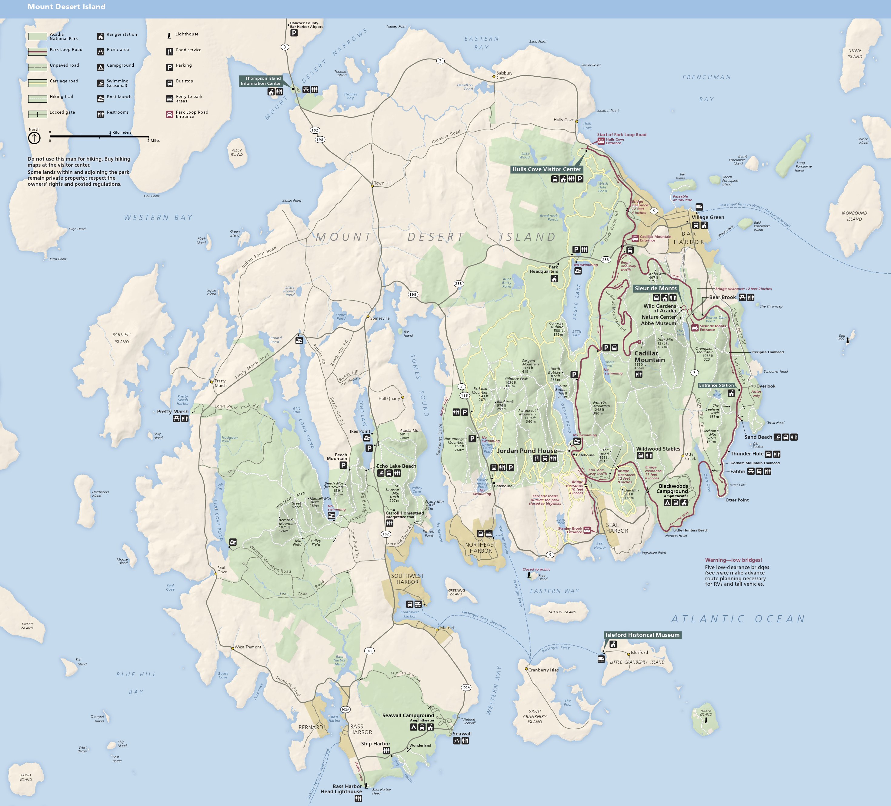
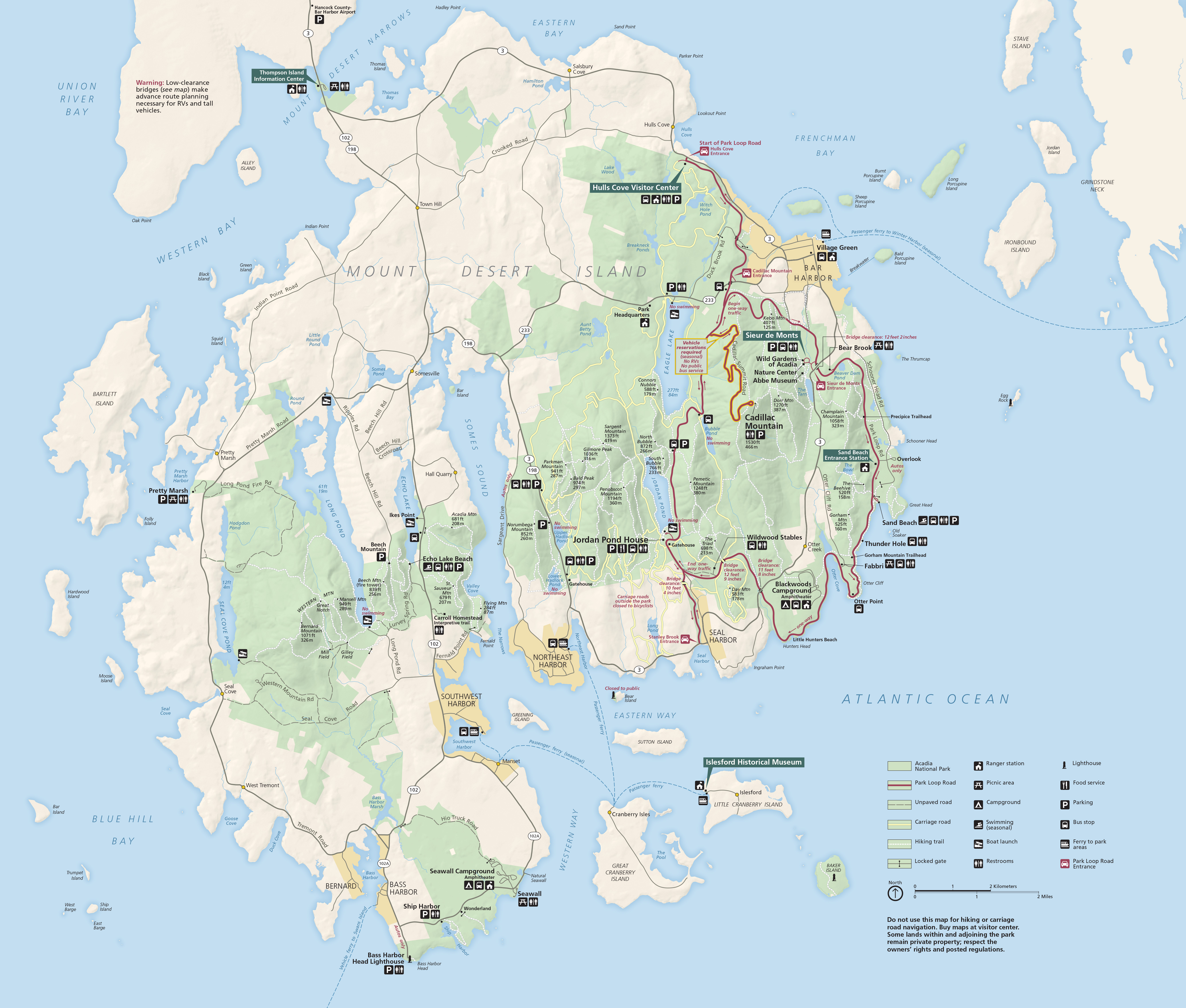 This is the official Acadia National Park map from the NPS brochure. This map focuses on the main part of the park, located on Mount Desert Island near Bar Harbor, Southwest Harbor, and Northeast Harbor.
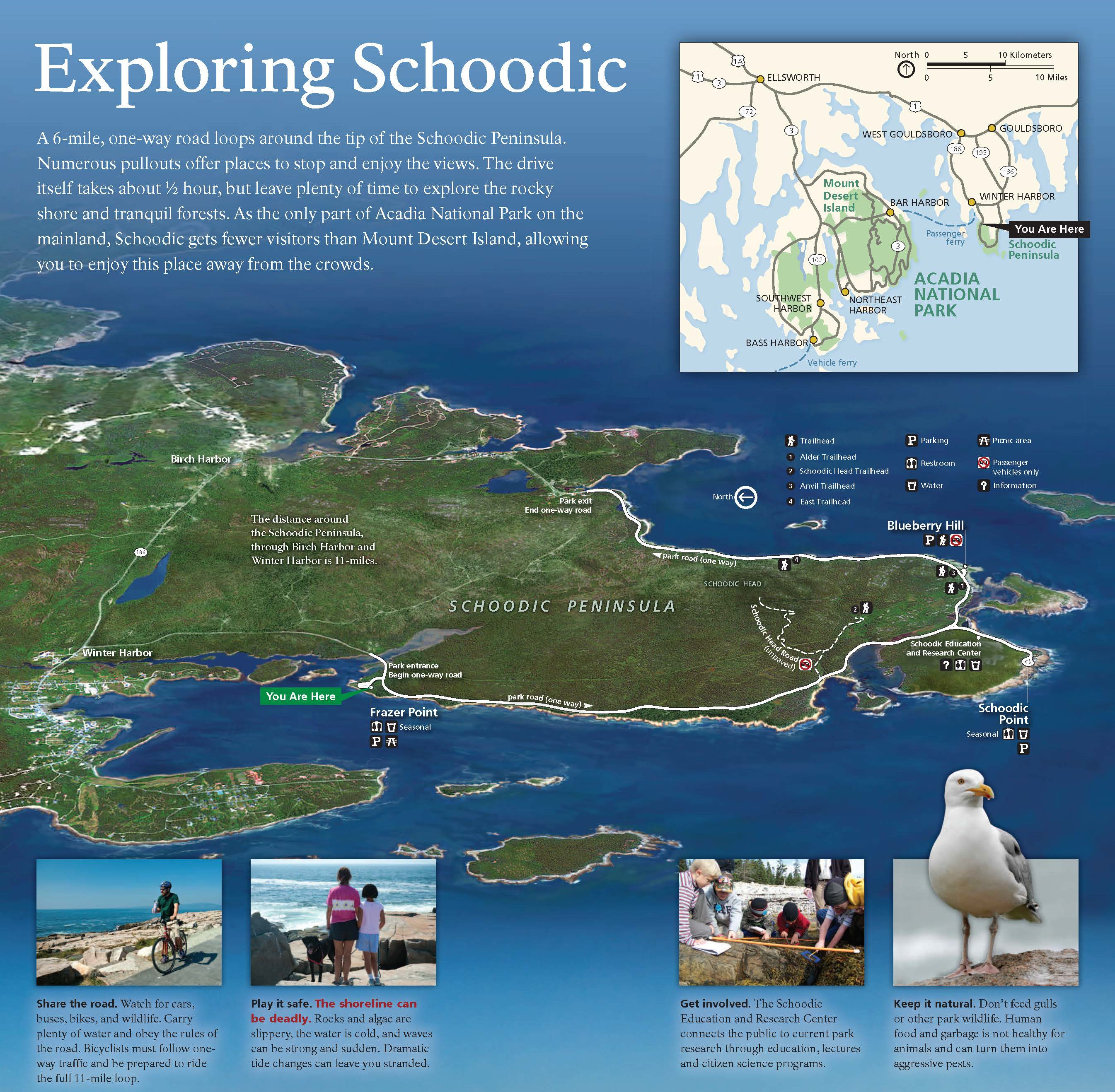
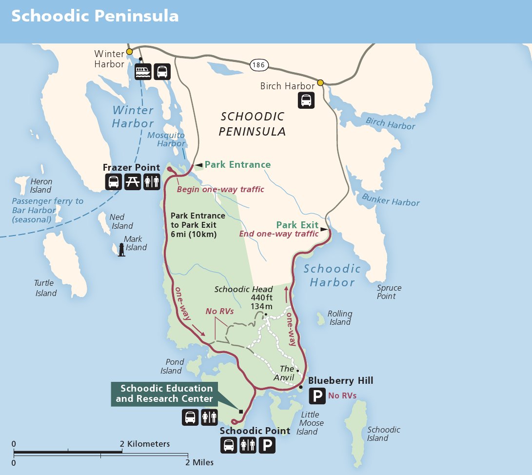
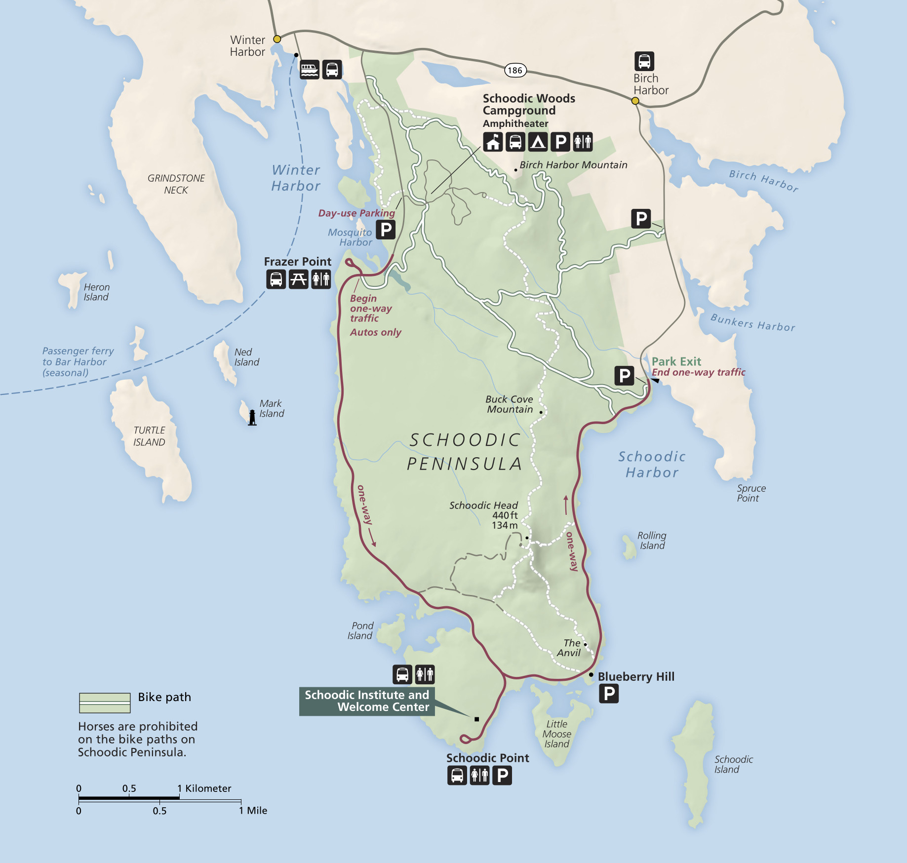 Here’s a Schoodic Peninsula map. Located on the mainland near Winter Harbor, a one-way loop road traverses the peninsula and includes Schoodic Point. You can drive or take the passenger ferry and bus from Bar Harbor.
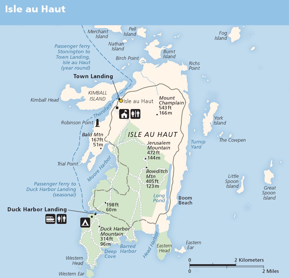
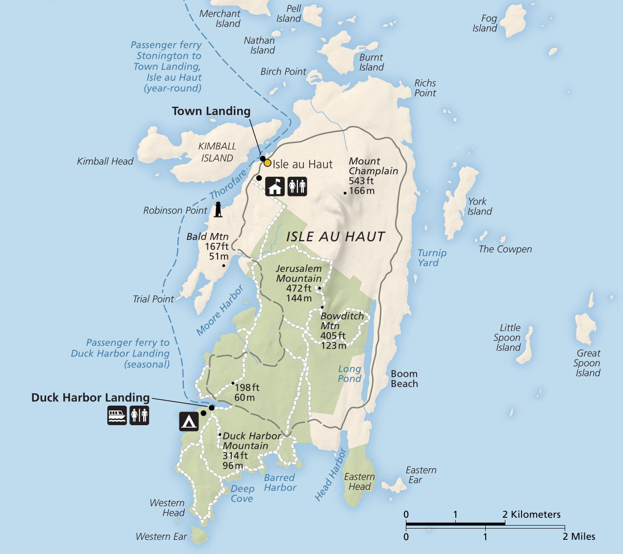 This Isle au Haut map zooms in on this island accessible by ferry from Stonington to Duck Harbor. Great for those wanting a quieter hiking experience! Click the image to view the full size map or download the PDF.
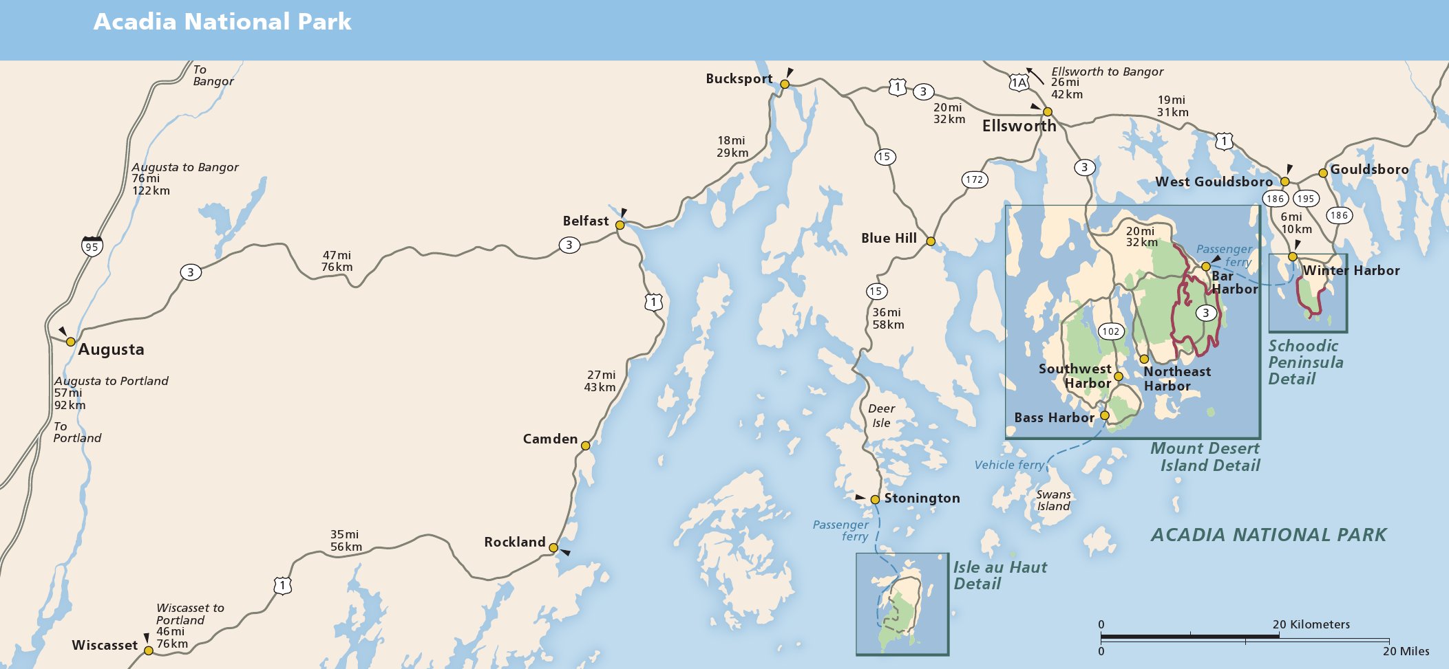
 The Acadia regional map zooms out to show where Isle au Haut and the Schoodic Peninsula are located in relation to Mount Desert Island. Click the image to view a full size map or download the PDF.
Acadia carriage road maps
 The Acadia carriage road map shows several different loops and identifies all historic bridges and their year of construction. These roads are for biking, hiking, horses, and skiing; no cars are permitted.
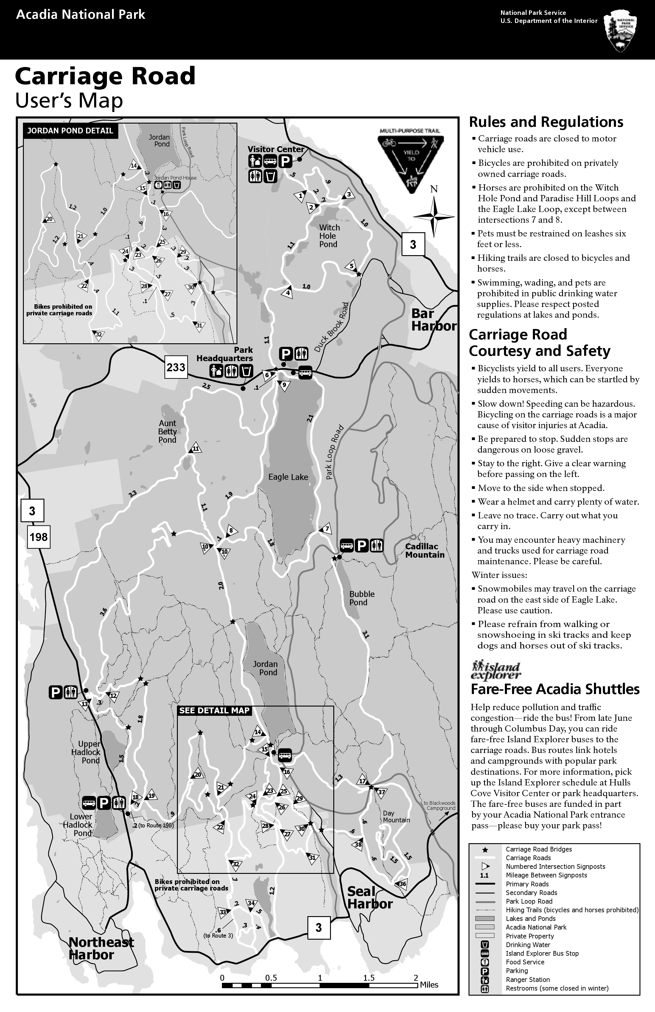 This printable carriage road map is affectionately known as the CRUM: Carriage Road User’s Map. Very handy to print and have folded in your pocket! Click the image to view a full size map or download the PDF.
Acadia trail maps
 If you’re looking for a detailed Acadia trails map, I recommend the Map Adventures waterproof trail map. This map contains topographic lines and trail mileages, so it is much superior to the free Acadia maps posted above. It usually sells for around $10 and is well worth the purchase if you’re going to do anything more than an easy walk. (This is a better map than the National Geographic Trails Illustrated Acadia map.)
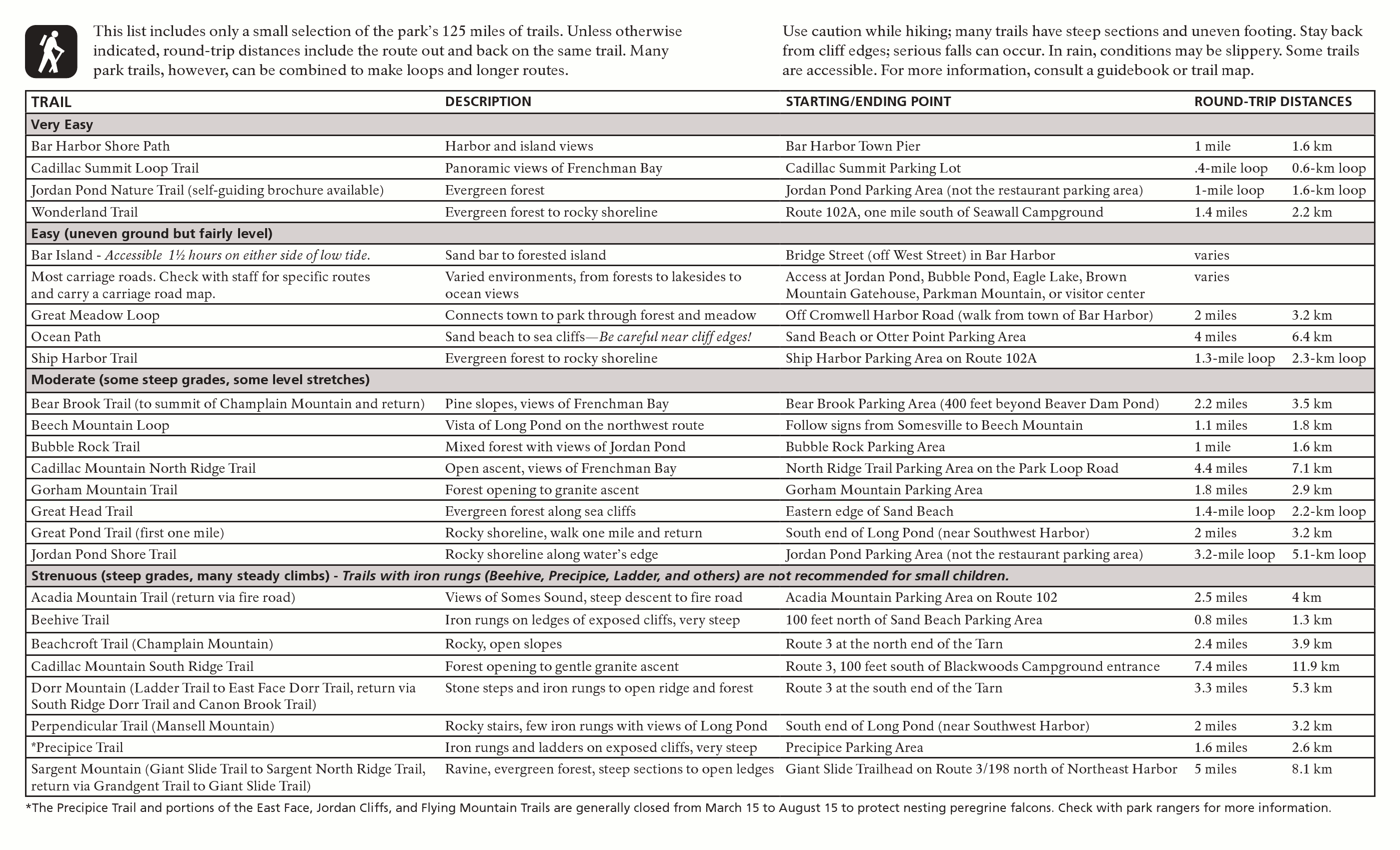 There is no free Acadia trail map with as much information as the paid maps, but this nice trail handout has an overview of the hikes. Click the image to view a full size map or download the PDF.
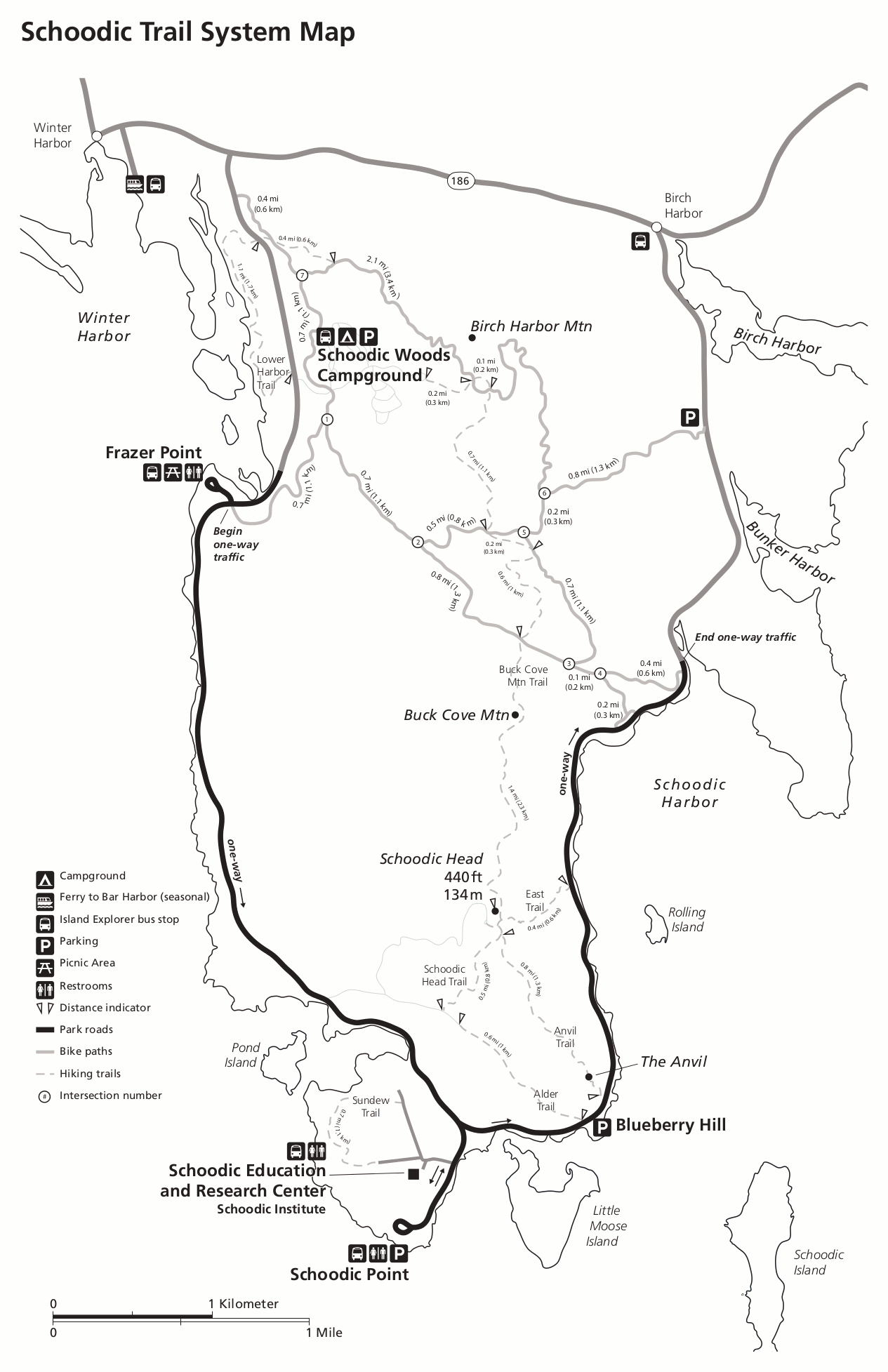 Here is a Schoodic Peninsula trail map, which shows popular hiking and biking trails on the peninsula near Schoodic Woods Campground. Click the image to view a full size map or download the PDF.
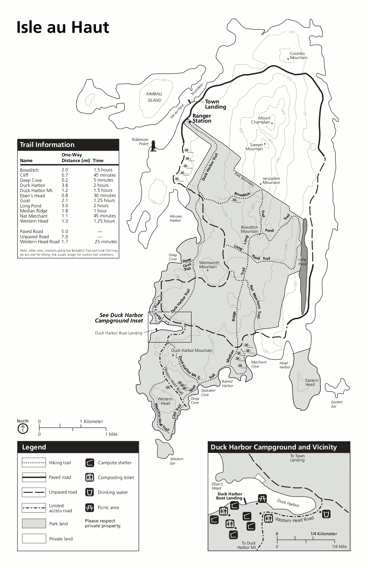 This is an Isle Au Haut trail map and includes an inset showing the Duck Harbor Campground. There are no vehicles permitted on this island. Click the image to view a full size map or download the PDF.
Acadia photorealistic maps
 This 3D Jordan Pond map labels the major features of the Jordan Pond area, ranging from Cadillac Mountain in the east to Penobscot Mountain to the west (and including the Jordan Pond House).
 Here’s another aerial map of Jordan Pond, showing an artistic perspective of Jordan Pond, the Jordan Pond House, the Bubbles, and surrounding trails — but without any labels.
 This is a photorealistic 3D Schoodic Peninsula map. This map is on a wayside exhibit at Frazer Point, near the start of the one-way Schoodic loop road, and labels trailheads, restrooms, parking areas, and water availability.
Acadia lodging map
 When visiting Acadia, most want to stay in Bar Harbor; to the right you can open an Expedia interactive Acadia lodging map. Bar Harbor is where you’ll have the most dining options and attractions, but there are quieter areas of Mount Desert Island too. You may want to see Expedia’s top-rated Acadia lodging where you can compare location, prices, and photos to see where you want to stay on Mount Desert Island.
Acadia winter maps
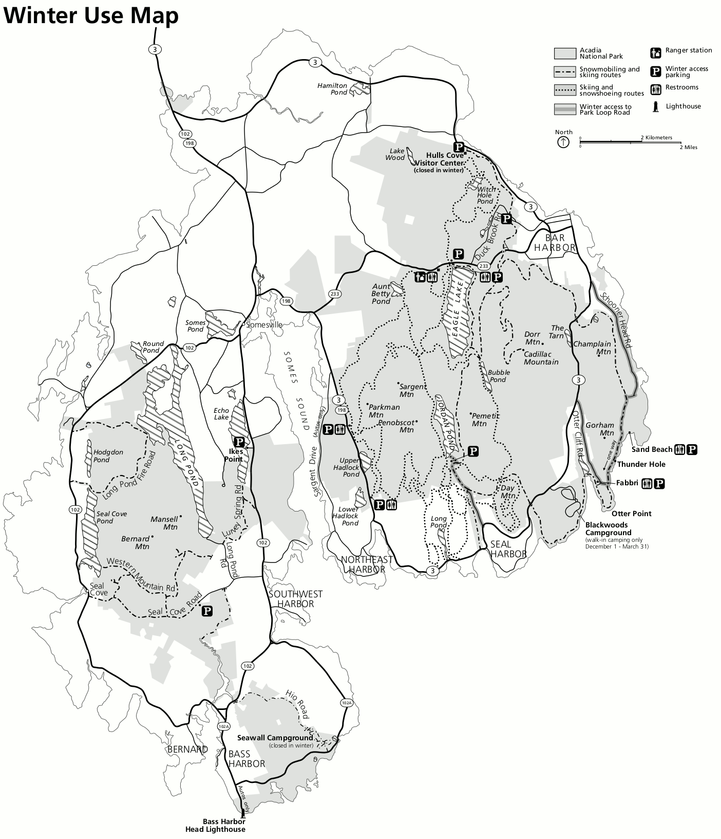
 This is an Acadia winter access map, which shows how and where one can access the Park Loop Road and carriage roads during the winter months, labeling which roads are open and closed to vehicles.
 This Acadia ski trail map labels several sections of the carriage road system that are groomed for cross-country skiing. Parking areas to access the trails at Jordan Pond House, Brown Mountain, and Parkman Mountain are shown.
 This Acadia ski map was superseded by the ski map directly above. But I find the color scheme makes this one easier to interpret, so I still consider it useful. Click the image to view a full size map or download the PDF.
Assorted Acadia maps
 This Acadia campgrounds map shows the location of each park campground: Blackwoods, Seawall, Duck Harbor, and Schoodic Woods. Note that just two are on Mount Desert Island near the main section of the park.
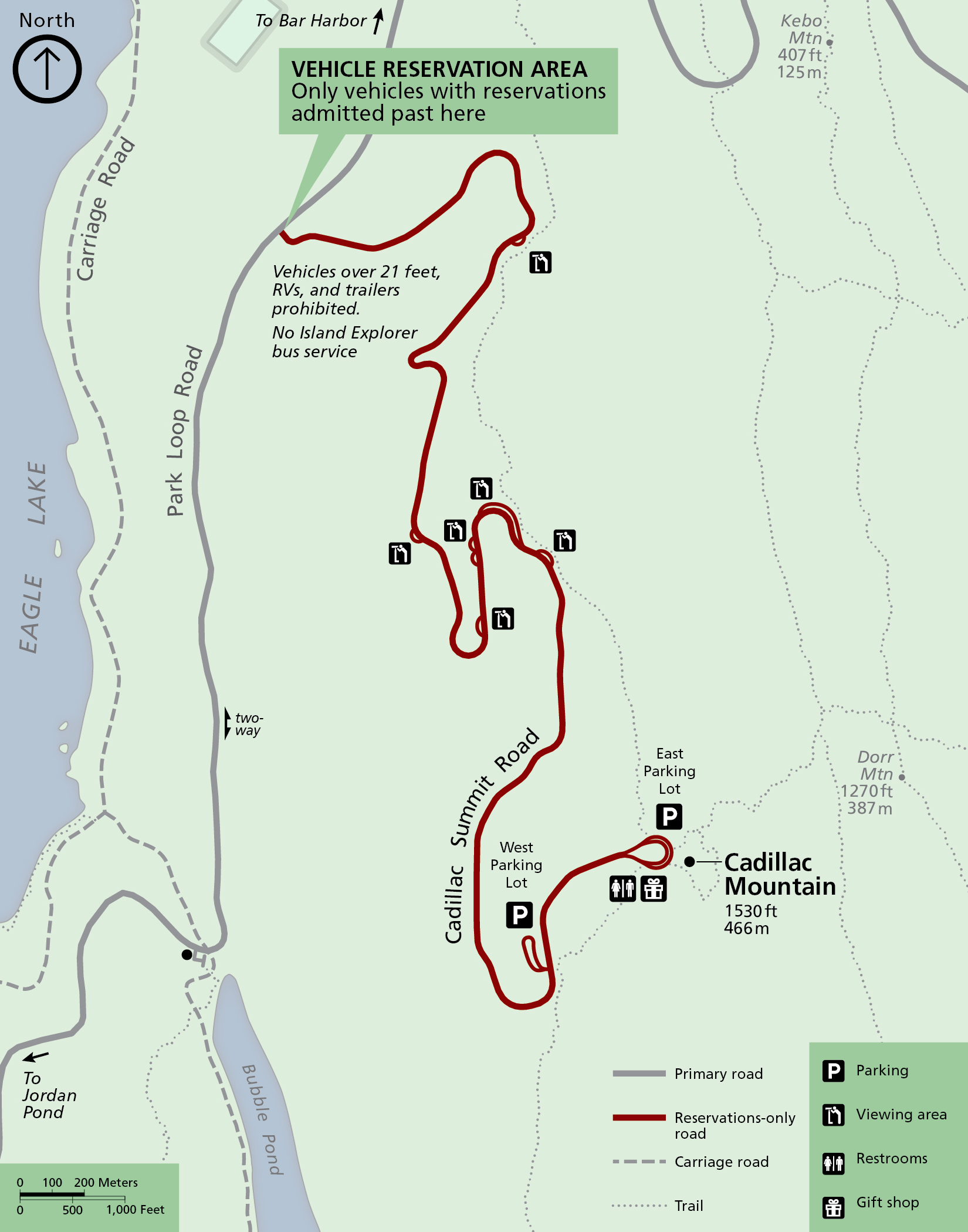 The Cadillac Mountain map focuses on access to the mountain, labeling parking areas and viewpoints along the Cadillac Summit Road. Take note of the vehicle reservation area, where permits are required due to crowding.
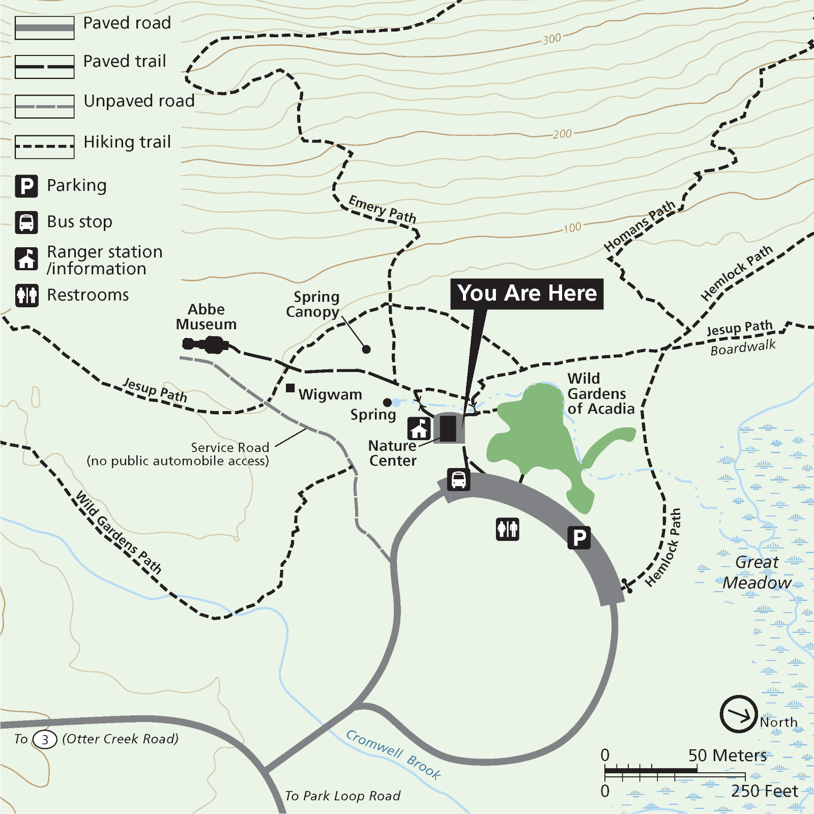 Here’s a Sieur de Monts map, which zooms in on this nice forested area near Bar Harbor. Here you’ll find some short flat hikes, the Abbe Museum, the Sieur de Monts Nature Center, and the Wild Gardens of Acadia.
 The Acadia road biking map color codes the Cadillac Summit Road and Park Loop Road based on where there is two-way traffic and one-way traffic to help cyclists plan their route and navigate safely.
Acadia topo maps
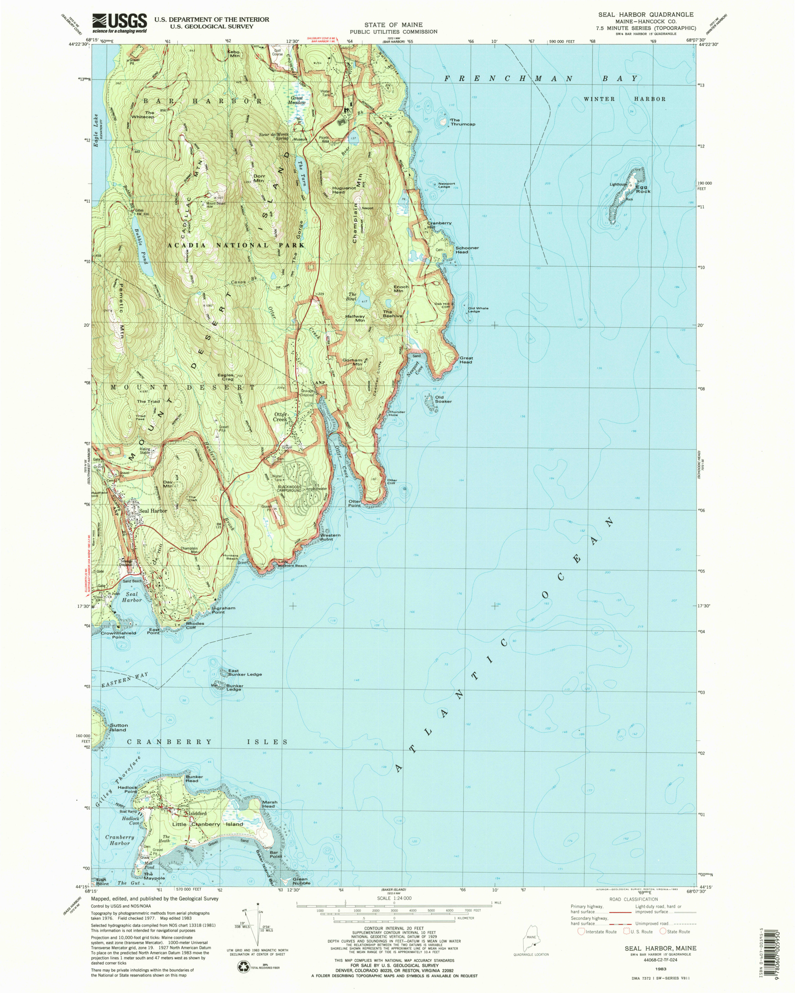 Here’s an Acadia East topo map, showing most of the park lands on the busier eastern part of Mount Desert Island. Click the image to view a full size map or download the PDF.
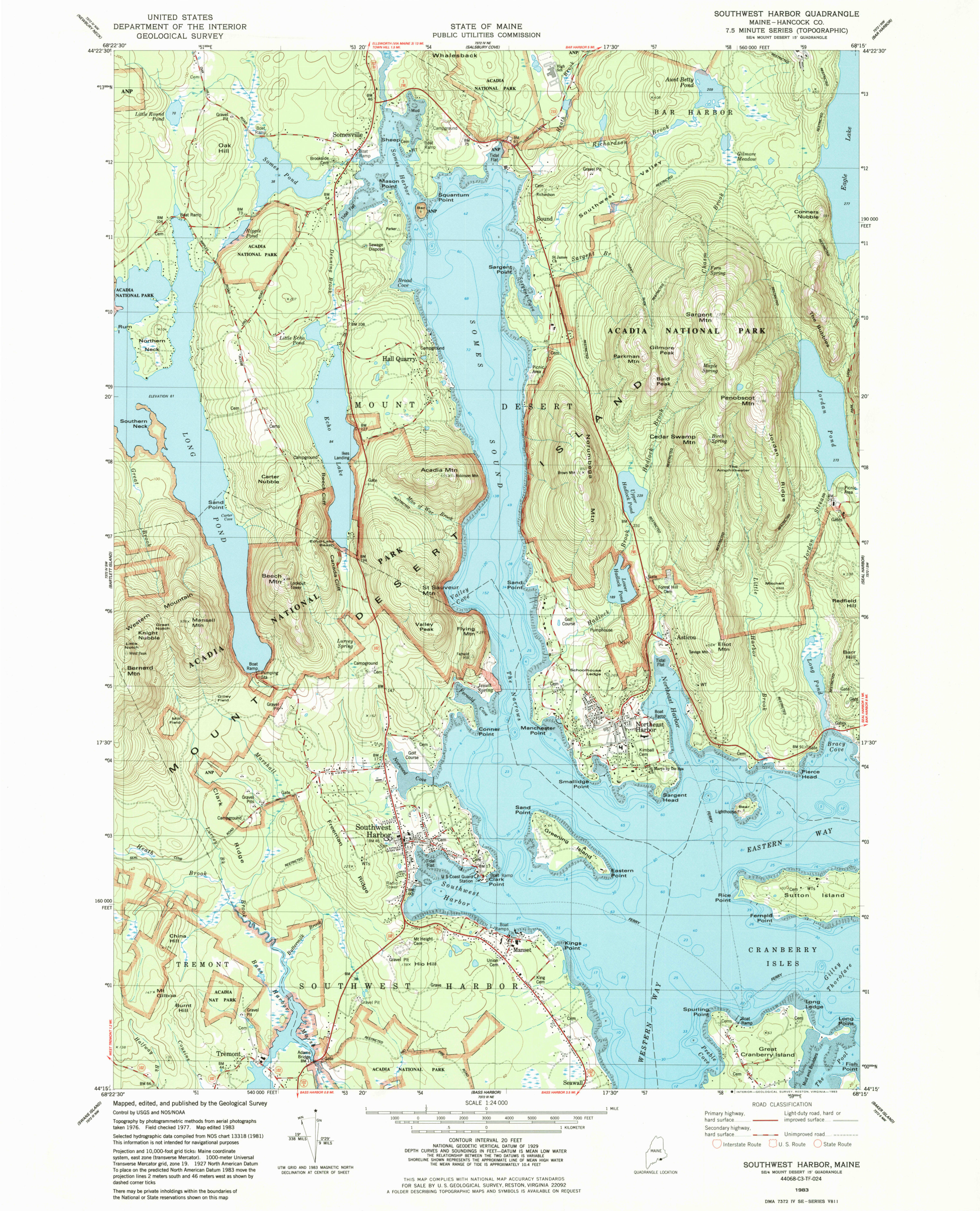 This is an Acadia West topo map, showing much of the park lands on the quieter, western side of Mount Desert Island. Click the image to view a full size map or download the PDF.
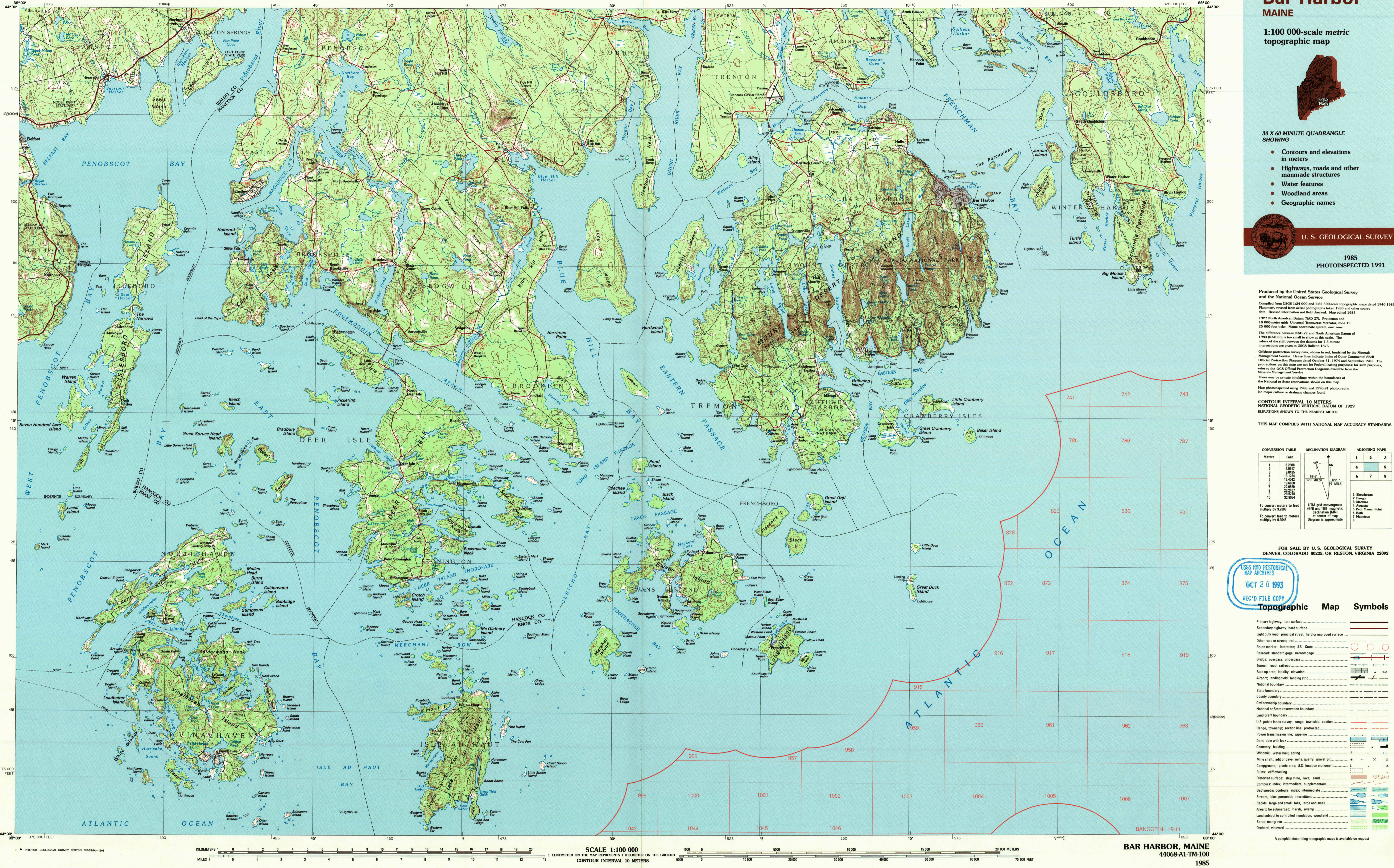 Here’s an Acadia topo map zooming out quite a bit to include the surrounding region of Downeast Maine, the Schoodic Peninsula, and islands to the southwest, including Isle Au Haut.
Acadia features maps
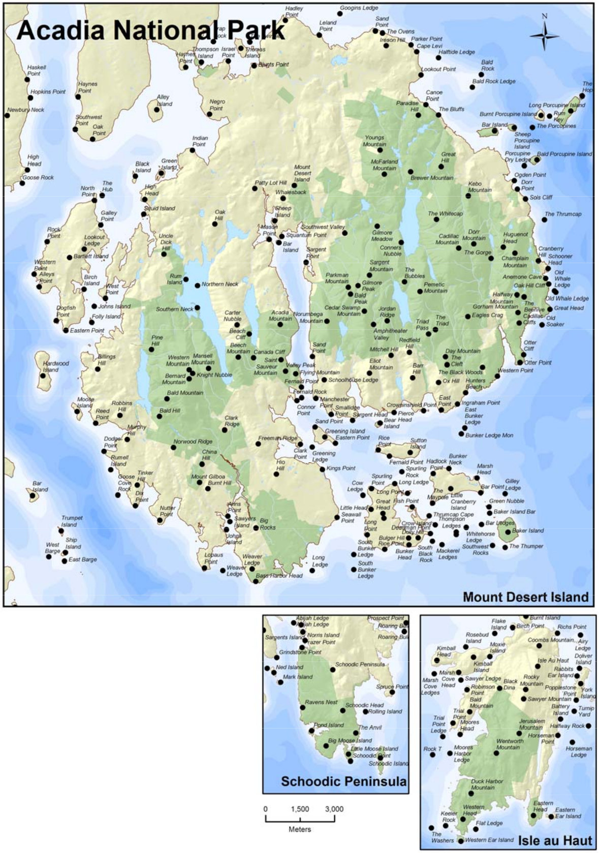 This Acadia named land features map labels mountains, rocks, and geological formations inside the national park that have official names. Can you find them all on your visit?
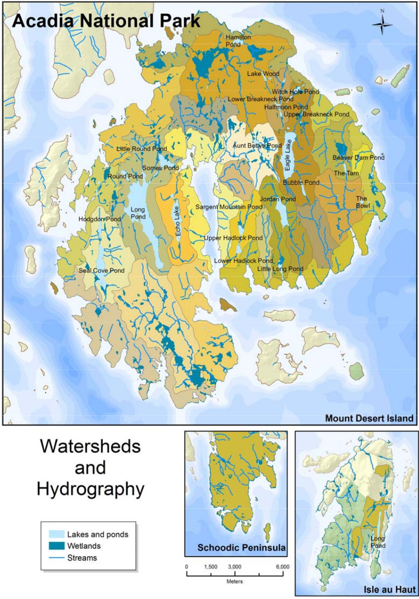 Here’s a named water features map of Acadia, labeling the ponds and lakes inside the park boundaries. Many of these you won’t see by car – get out and hike or bike on the carriage roads!
Acadia science maps
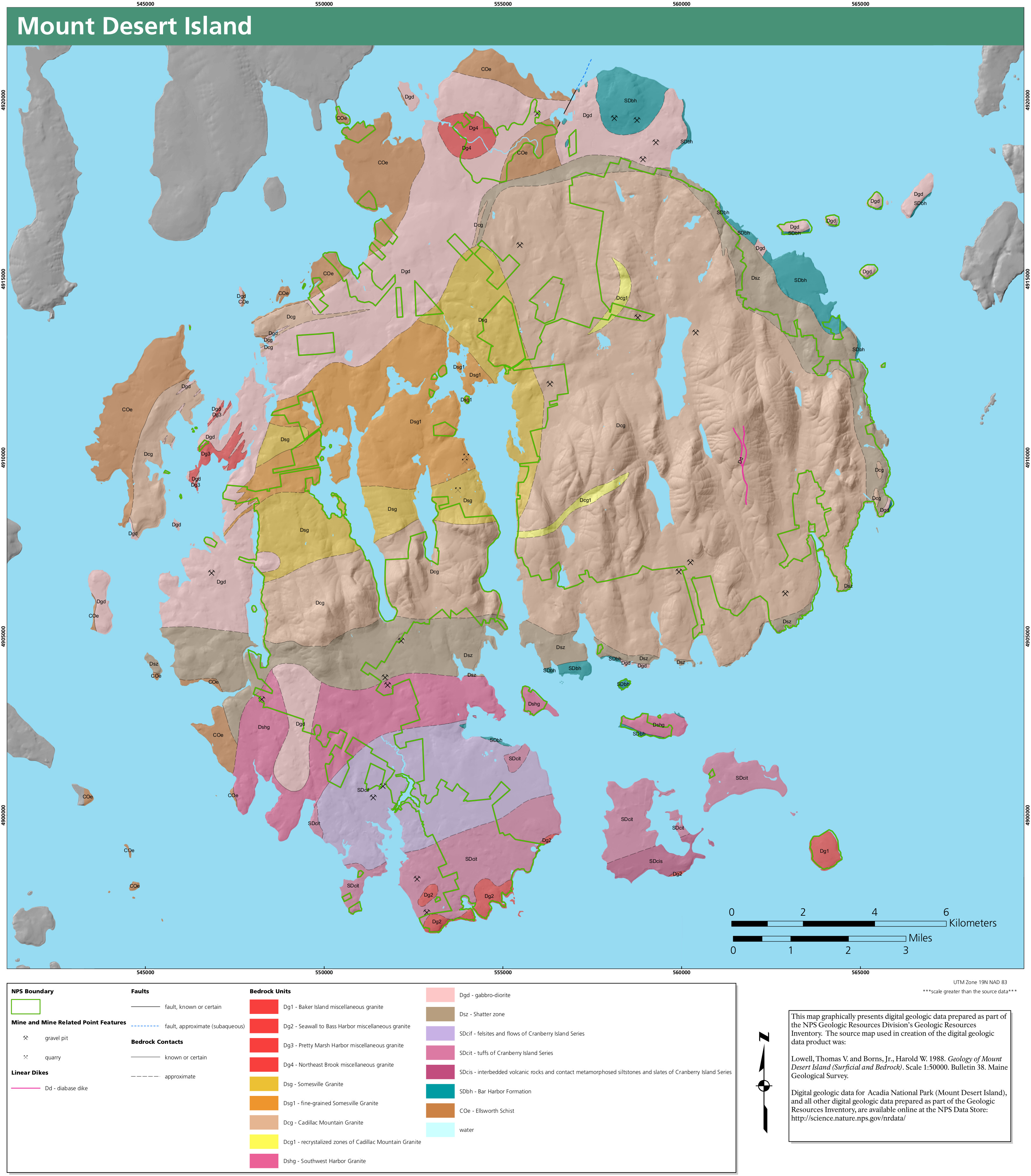 Here’s an Acadia bedrock geology map, showcasing the variety of granites and other rocks that make up the bedrock of Mount Desert Island. Now’s your chance to learn about that pink granite!
 This Acadia surficial geology map shows the rock deposits and sediments that are found at the surface of Mount Desert Island, overlying the bedrock found underneath.
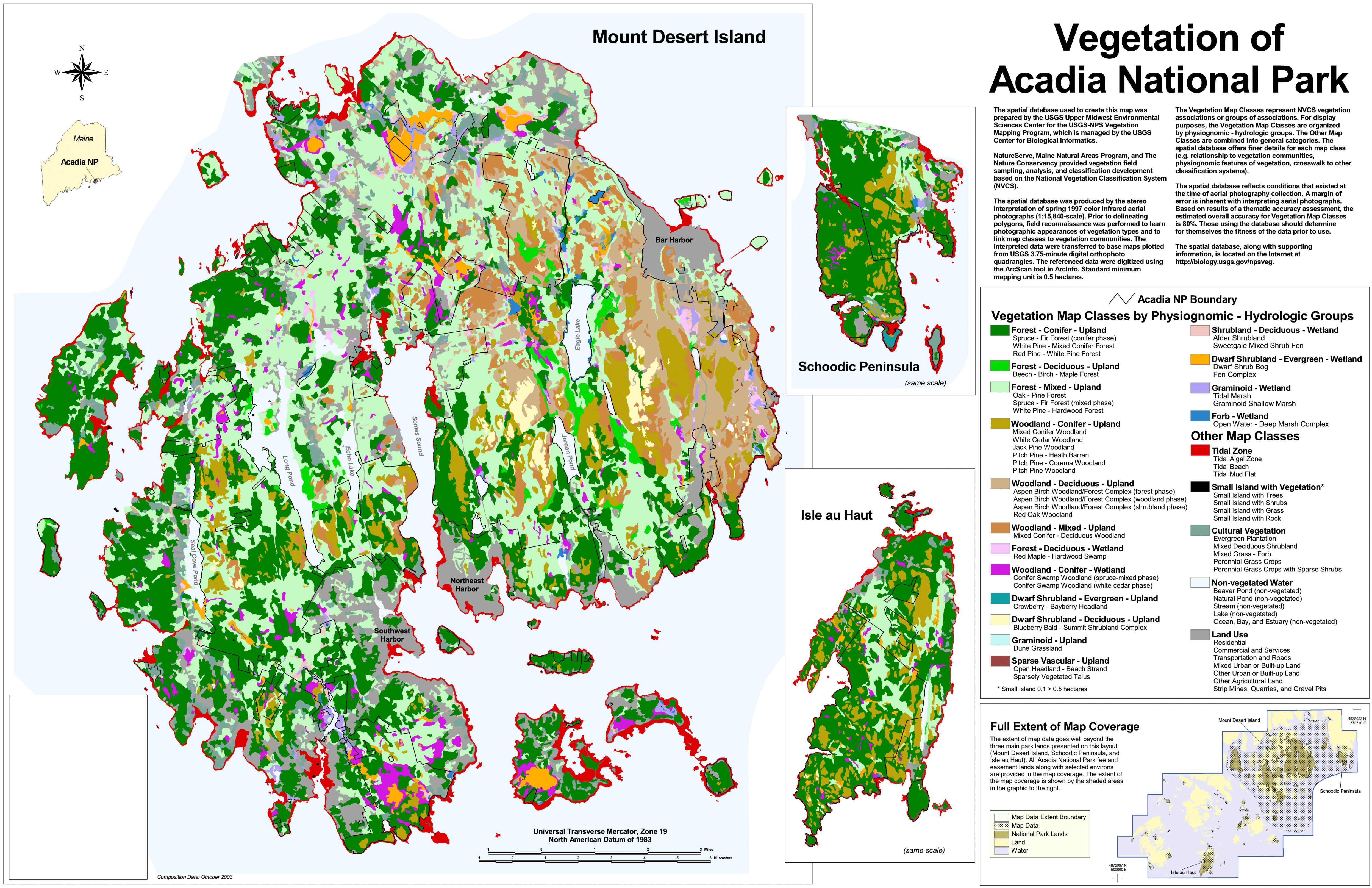 This is an Acadia vegetation map, plotting out what grows at every point on Mount Desert Island – woodland forest, conifer forest, shrublands, tidal zones, bare granite, and so on.
Archived Acadia maps
The National Park Service is constantly updating maps, and I do my best to add new ones to the page as they’re released. The ones below have been superseded by new ones above, but I’ve provided them here for archival purposes so users can see how parks change over time.
 This was the main Acadia National Park map from the mid-2010s, showing the majority of the park located on Mount Desert Island near Bar Harbor. Click the image to view a full size map or download the PDF.
 This is an old Isle au Haut map from the mid-2010s, showing the Acadia island accessible only by ferry and open just to hiking and camping. Click the image to view the full size map or download the PDF.
 This Acadia map is of the Schoodic Peninsula from the mid-2010s. Note that there’s no Schoodic Woods campground yet on this map (it opened in 2015). Click the image to view a full size map or download the PDF.
 This is an old Acadia regional map showing the location of each of Acadia National Park’s units, including the Schoodic Peninsula and Isle Au Haut. Click the image to view a full size map or download the PDF.
 This is an old Acadia winter map, showing ski, snowmobile, and snowshoe routes and winter Park Loop Road access. It’s pretty hard to read and has been superseded by the winter maps higher on this page.
Acadia map prints and gifts

 Printed high-resolution Acadia map posters and other products are available at the Acadia National Park Maps store. For art prints, gift ideas, and souvenirs featuring other national parks, support this site and visit the National Park Maps store; you’ll find items to bring on vacation, keep at home for the memories, or give to your park-enthusiast friends and loved ones.
…and more!
< Return to National Park Maps home
< Return to Park List
< Return to List by State