Grand Teton map from the park brochure
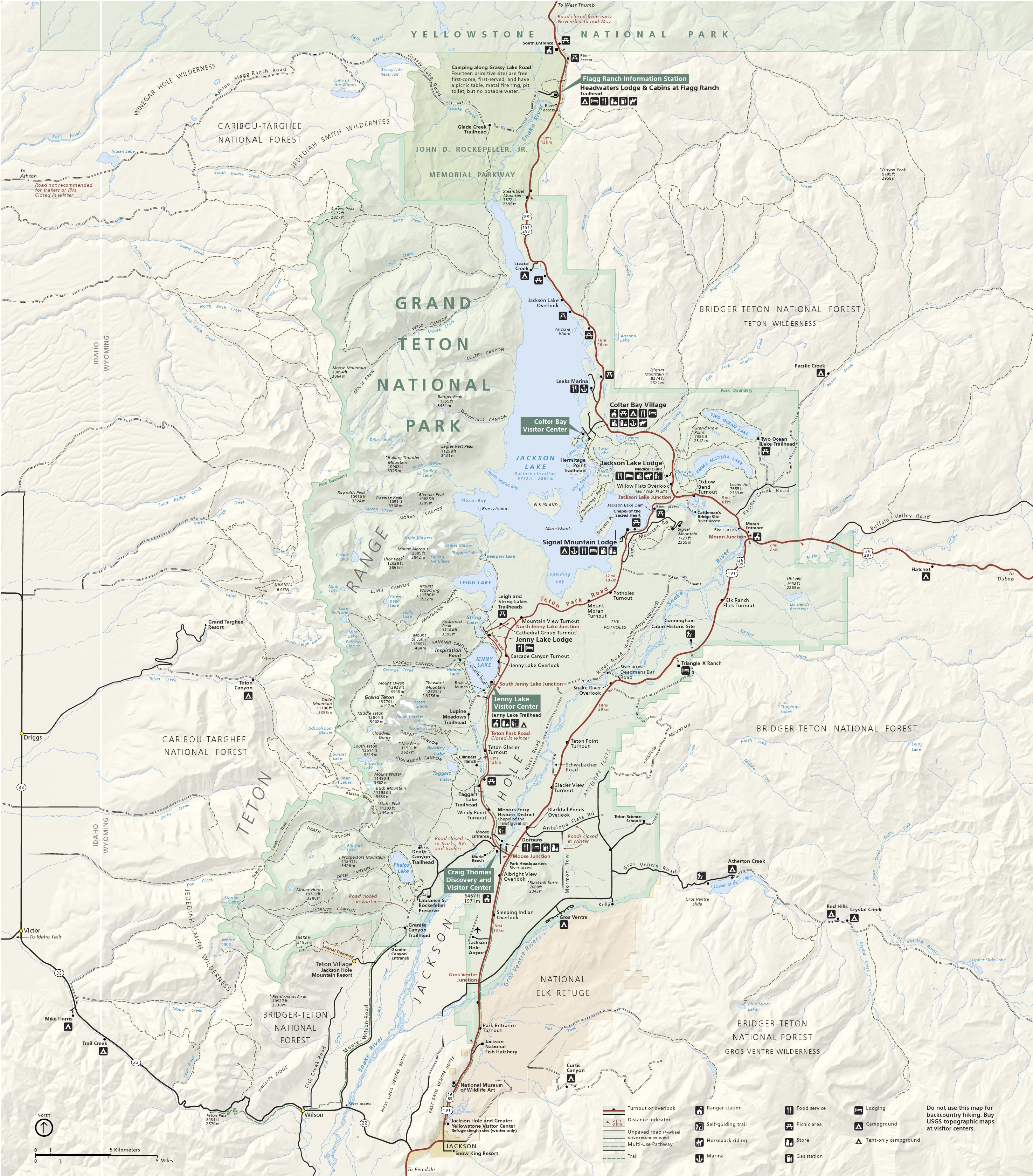
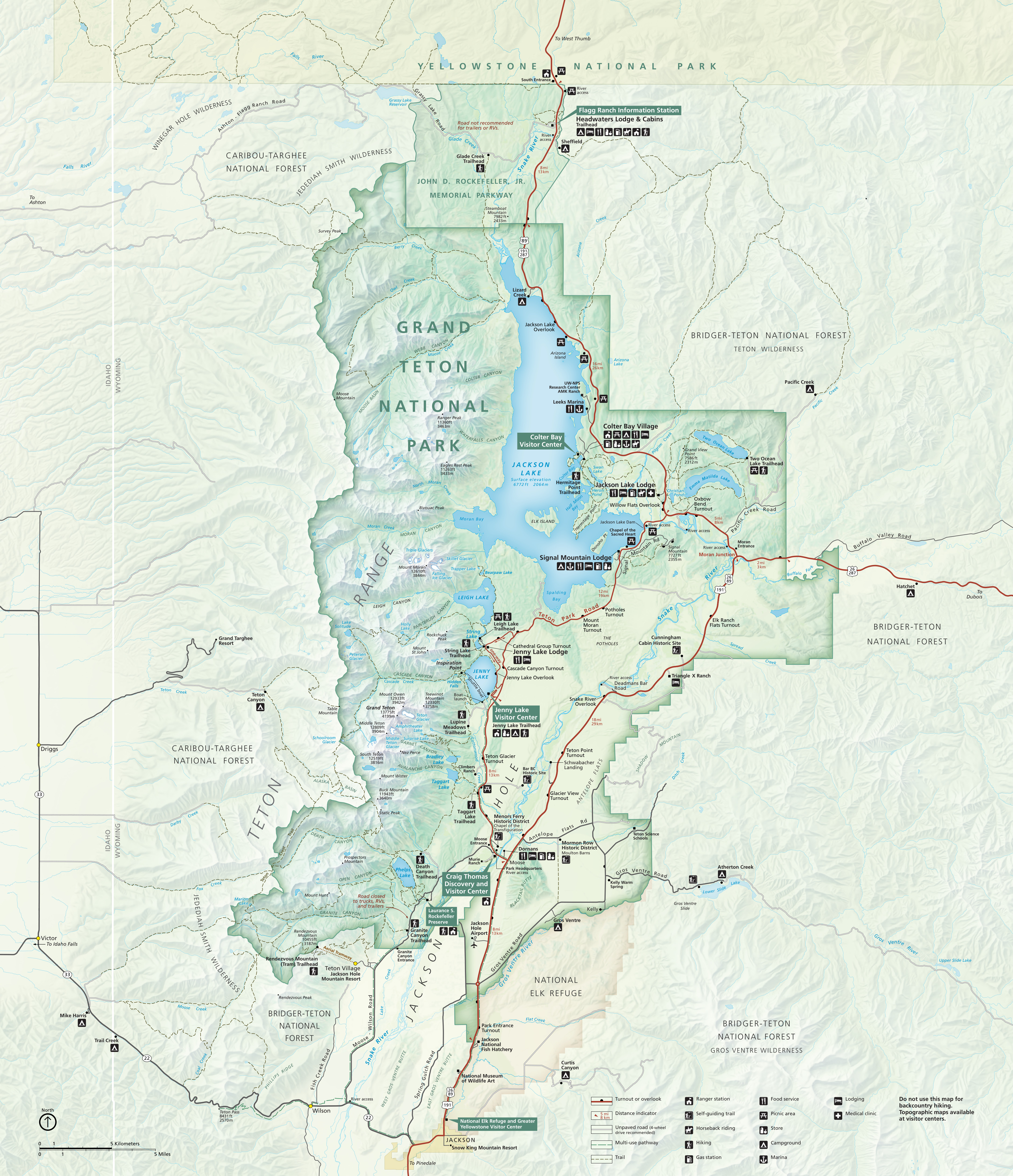 This is the Grand Teton National Park map from the official National Park Service brochure, last updated in 2024 with more vibrant colors, shaded topography, and true-to-life color scheme.
Grand Teton trail maps
 The maps posted below are good if you’re visiting by car, but you’ll want to buy the Grand Teton National Geographic Trails Illustrated map if you plan to do lots of hiking or backpacking. It’s much more useful for navigation, as it includes topographic lines, backcountry campsites, and trail mileages. If you’re also visiting Yellowstone, you can save money by buying the Grand Teton/Yellowstone map pack, covering both parks.
 The Grand Teton hiking map includes all the maps in this section on a single graphic. This map might be a little unwieldy to view and use, so below I’ve provided individual trail maps for the specific hikes you’re interested in.
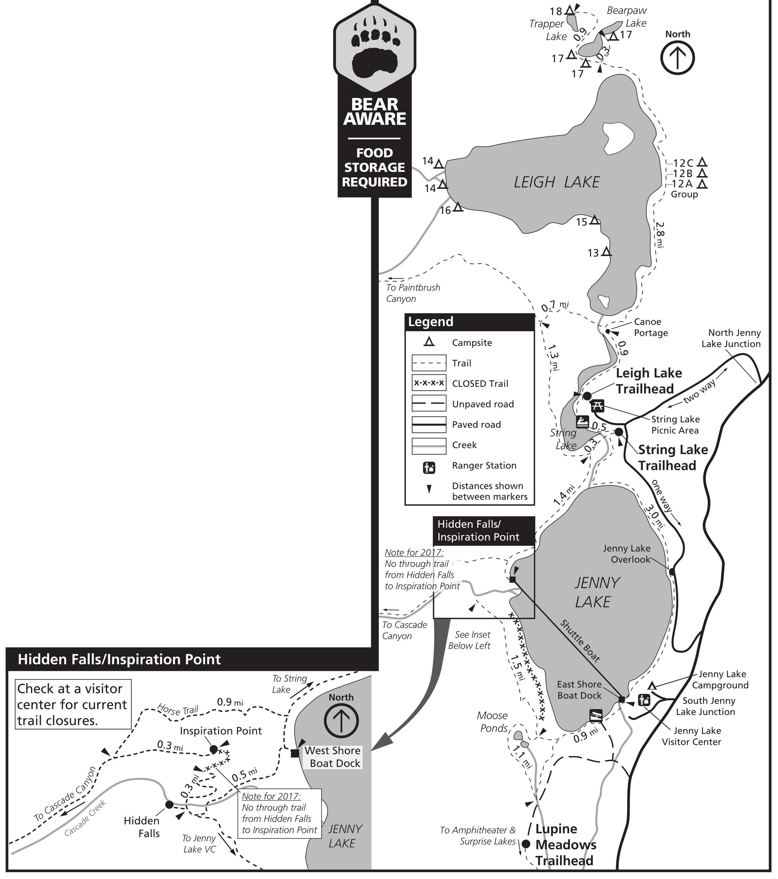 This Jenny Lake trail map also includes Leigh Lake and String Lake, as well as an inset showing the busy area around Hidden Falls and Inspiration Point. Trail construction is very common here so check first with NPS staff.
 Here’s a Jackson Lake trail map, which also includes inset maps for the Hermitage Point trailhead area (near the Colter Bay Visitor Center, boat launch, and marina) and the Jackson Lake Lodge area.
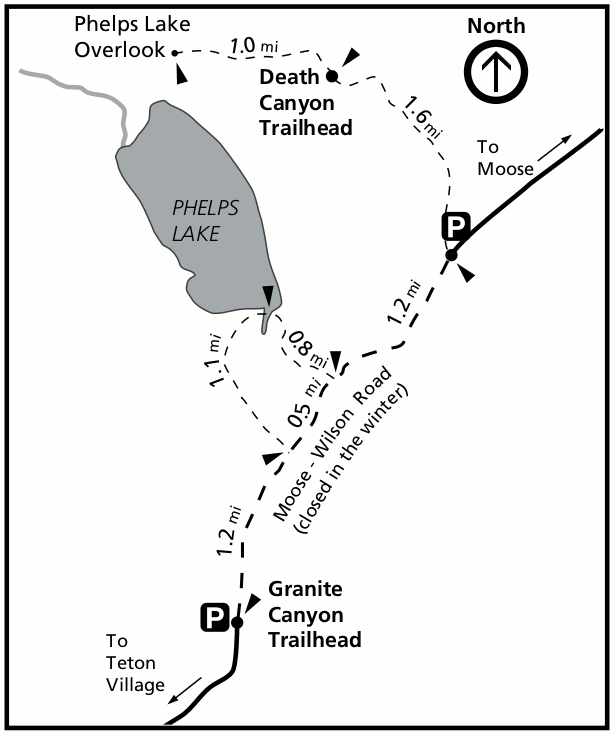
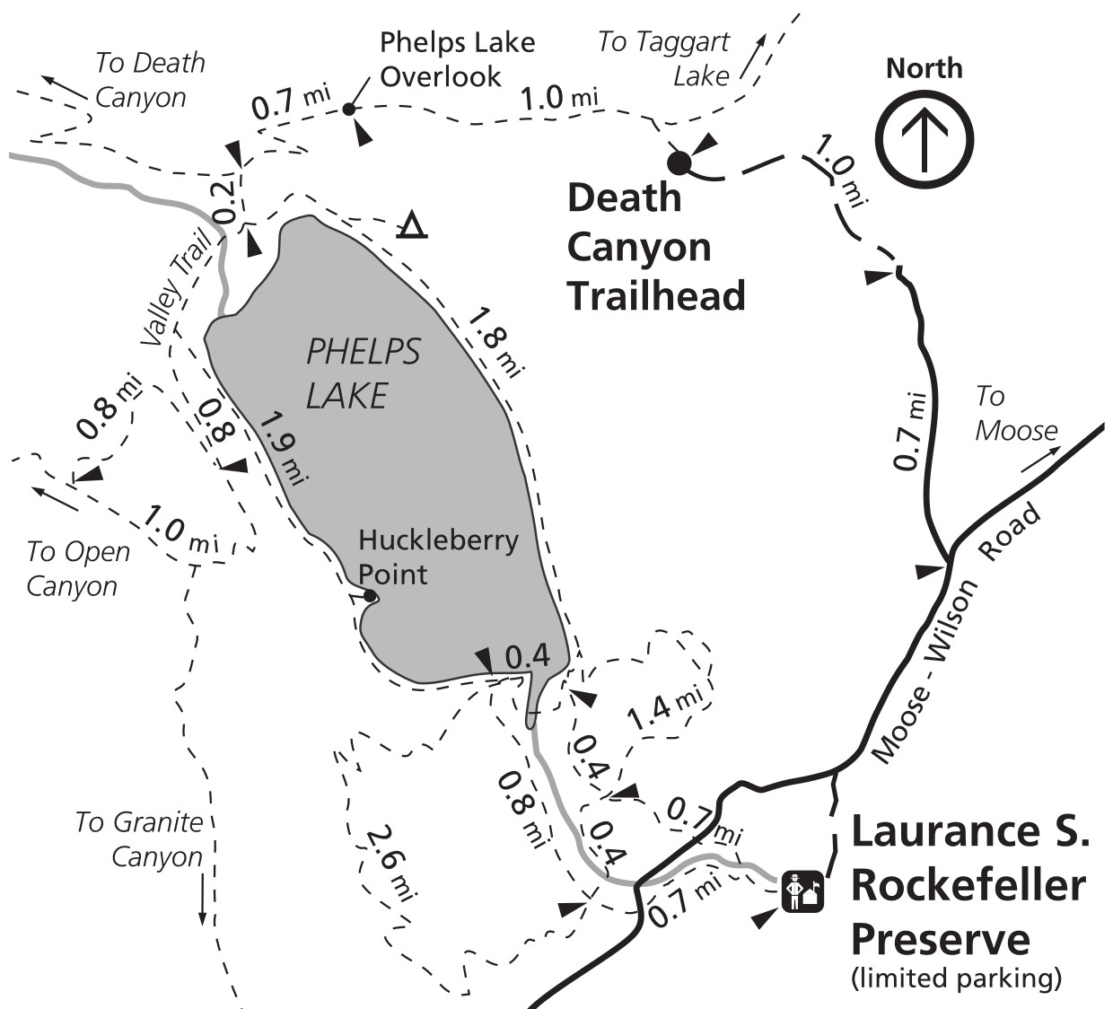 The Phelps Lake trail map zooms in on the Death Canyon Trailhead and loop trails around Phelps Lake, some of which eventually lead into Granite Canyon, Open Canyon, and Death Canyon.
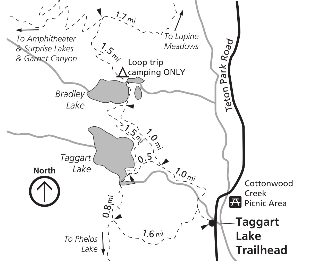 This Bradley and Taggart Lake trail map includes loop trails to and from the lakes, as well as the beginning of the strenuous hiking trail leading to Garnet Canyon and to Surprise and Amphitheater Lakes.
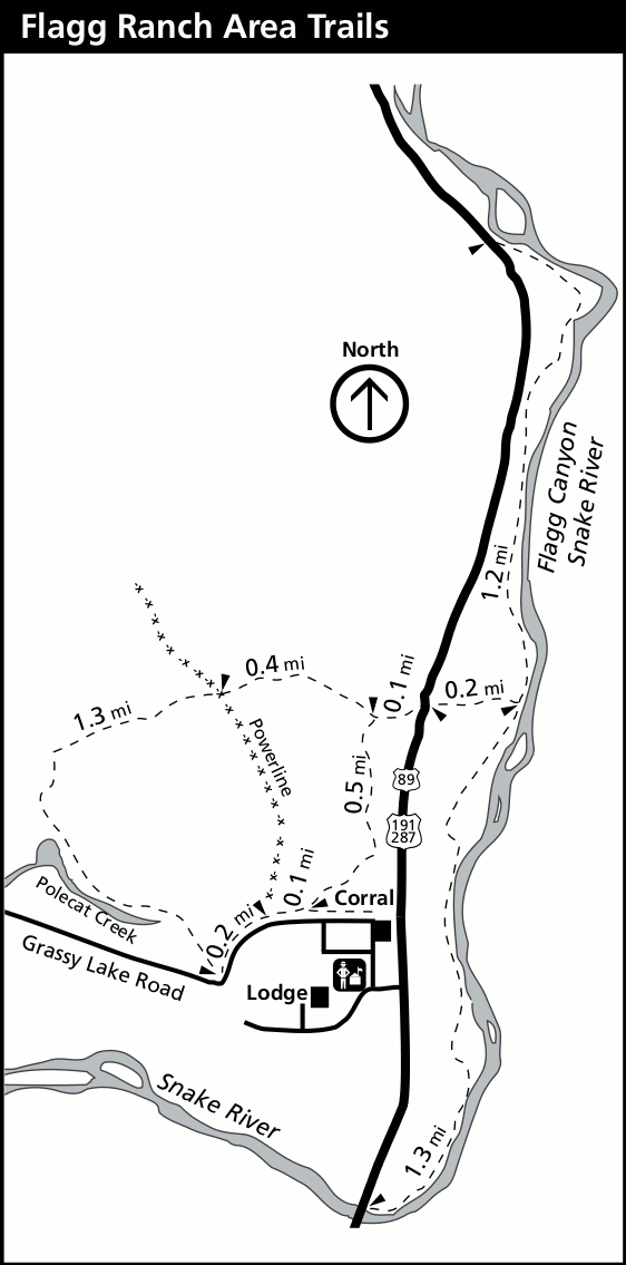
 This Flagg Ranch trail map shows an area managed by Grand Teton NPS staff, even though it’s technically outside the park. These trails are en route to Yellowstone on the John D. Rockefeller, Jr. Memorial Parkway.
Grand Teton hiking maps
The maps in this section are not as current as the ones above and are no longer available through the National Park Service. However, I am providing them here because I feel the topographic lines are so useful for hike planning. But please keep in mind that the ones in the section above are more likely to reflect current trail layout.
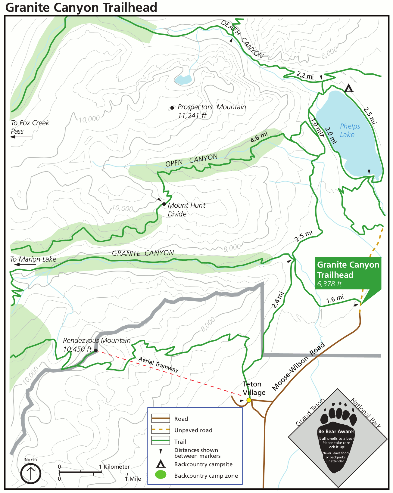 This is a Granite Canyon Trailhead map, showing trails toward Granite Canyon, Open Canyon and Phelps Lake, located off the Moose-Wilson Road (just a bit north of Teton Village).
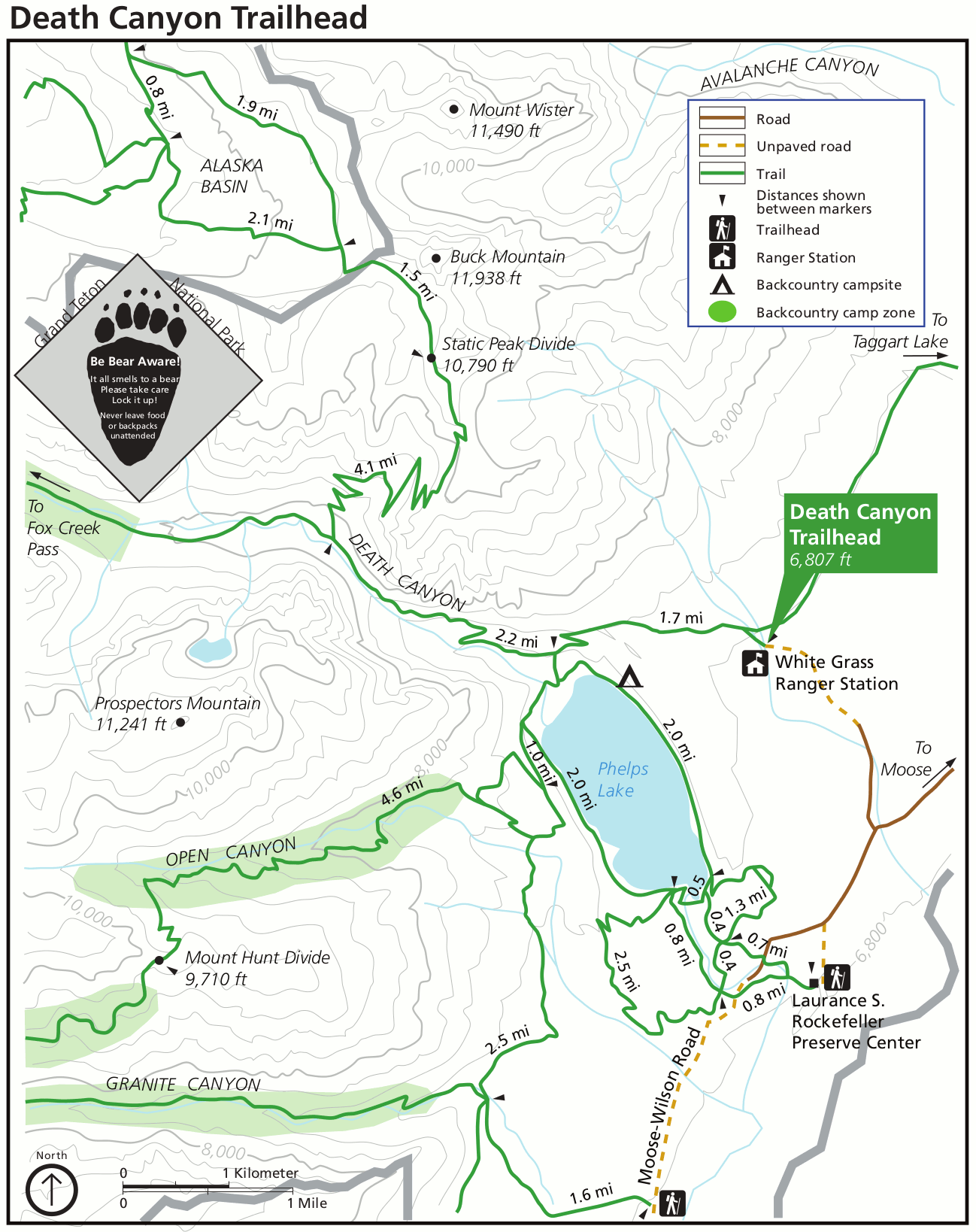 This is a Death Canyon Trailhead map, showing trails surrounding Phelps Lake and into Death Canyon, Open Canyon, Granite Canyon, and others, south of the main Grand Teton peaks.
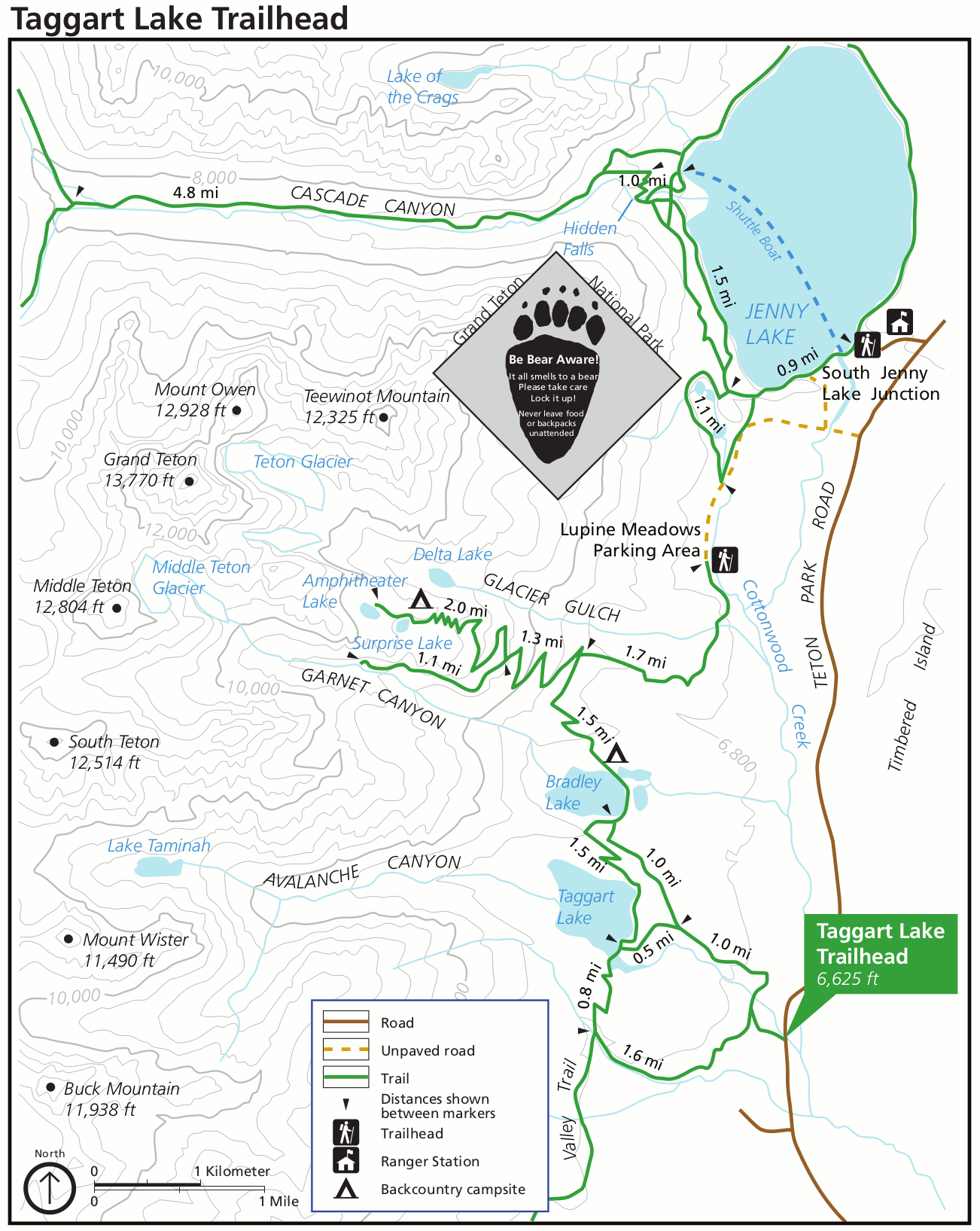 The Taggart Lake Trailhead map shows trails to Taggart Lake, Bradley Lake, Surprise Lake, and Amphitheater Lake. You’ll find this on the Teton Park Road, south of Jenny Lake.
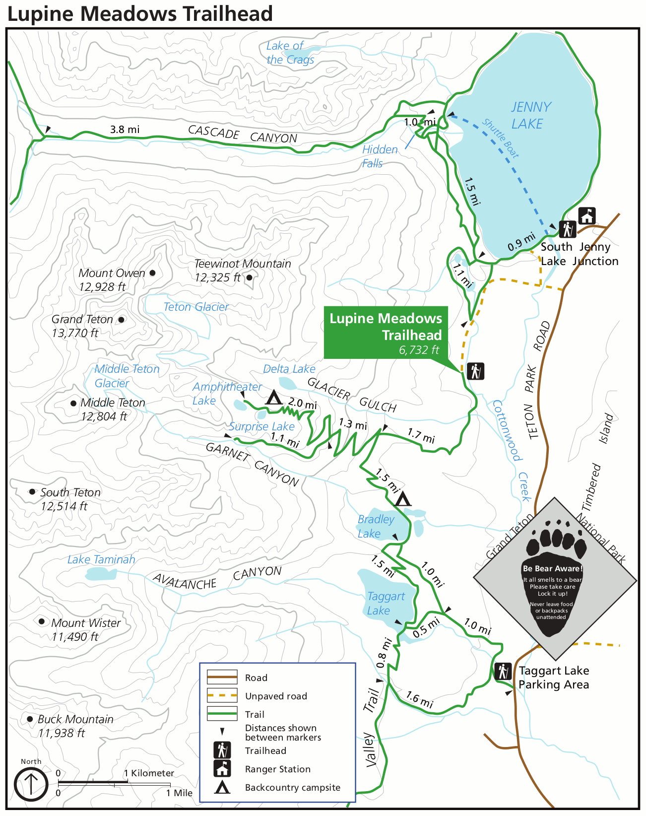 This is a Lupine Meadows Trailhead map, which shows the shortest routes to Surprise Lake, Amphitheater Lake, and Garnet Canyon. It’s located at the end of an unpaved road south of Jenny Lake.
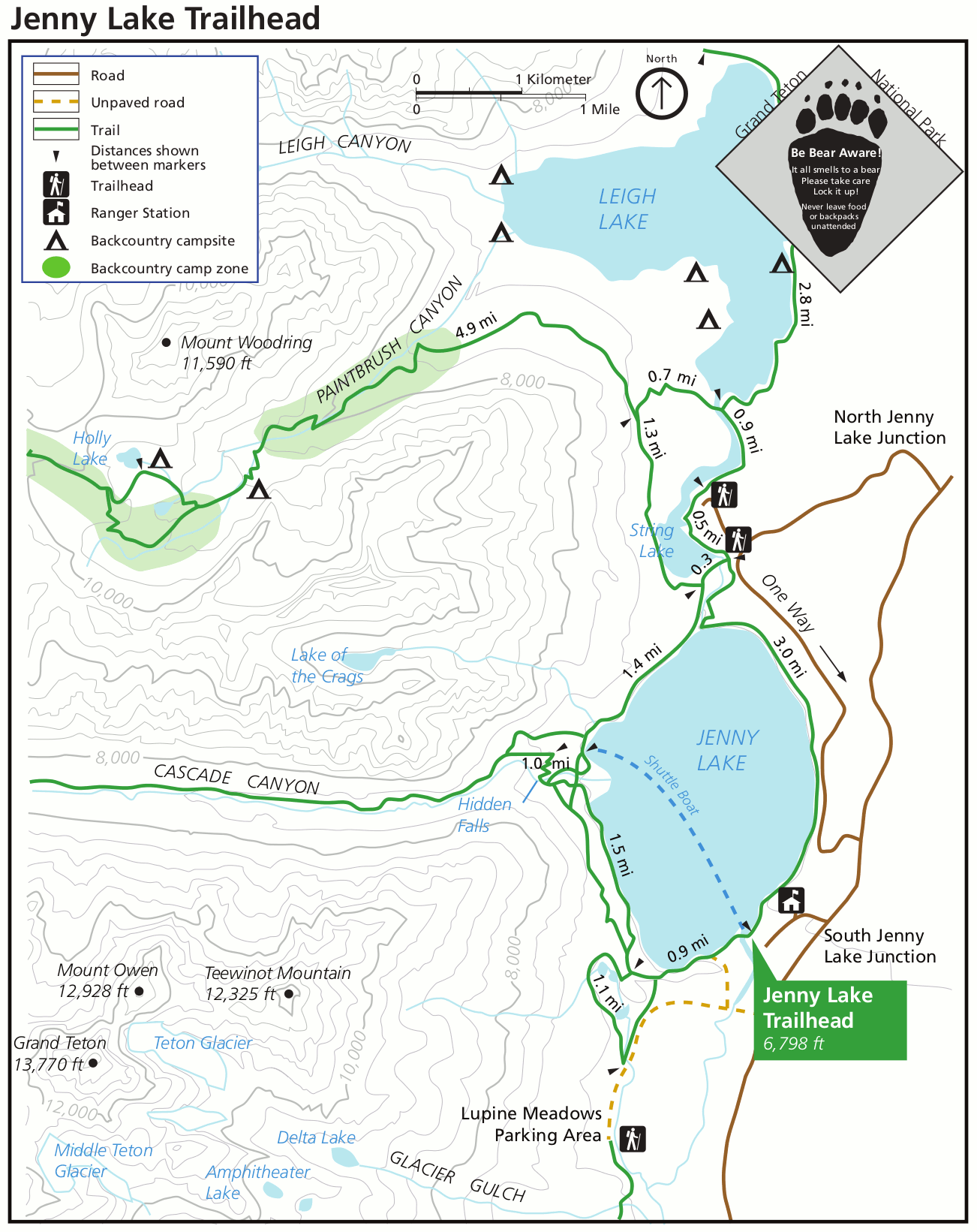 Here’s a Jenny Lake Trailhead map, showing the shuttle boat route and trails to Hidden Falls and Cascade Canyon north of Mount Owen and Grand Teton. This is an incredibly popular area!
 The String Lake Trailhead map shows trails starting from String Lake, located between Jenny Lake and Leigh Lake. These trails provide access into Paintbrush Canyon (north) and Cascade Canyon (south).
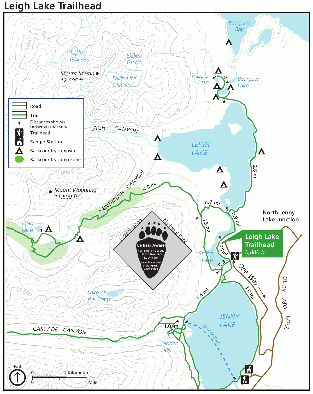 This is a Leigh Lake Trailhead map, showing trails to Paintbrush Canyon and along Leigh Lake to Bearpaw Lake and Trapper Lake. This is pretty much in the exact same place as the String Lake trailhead.
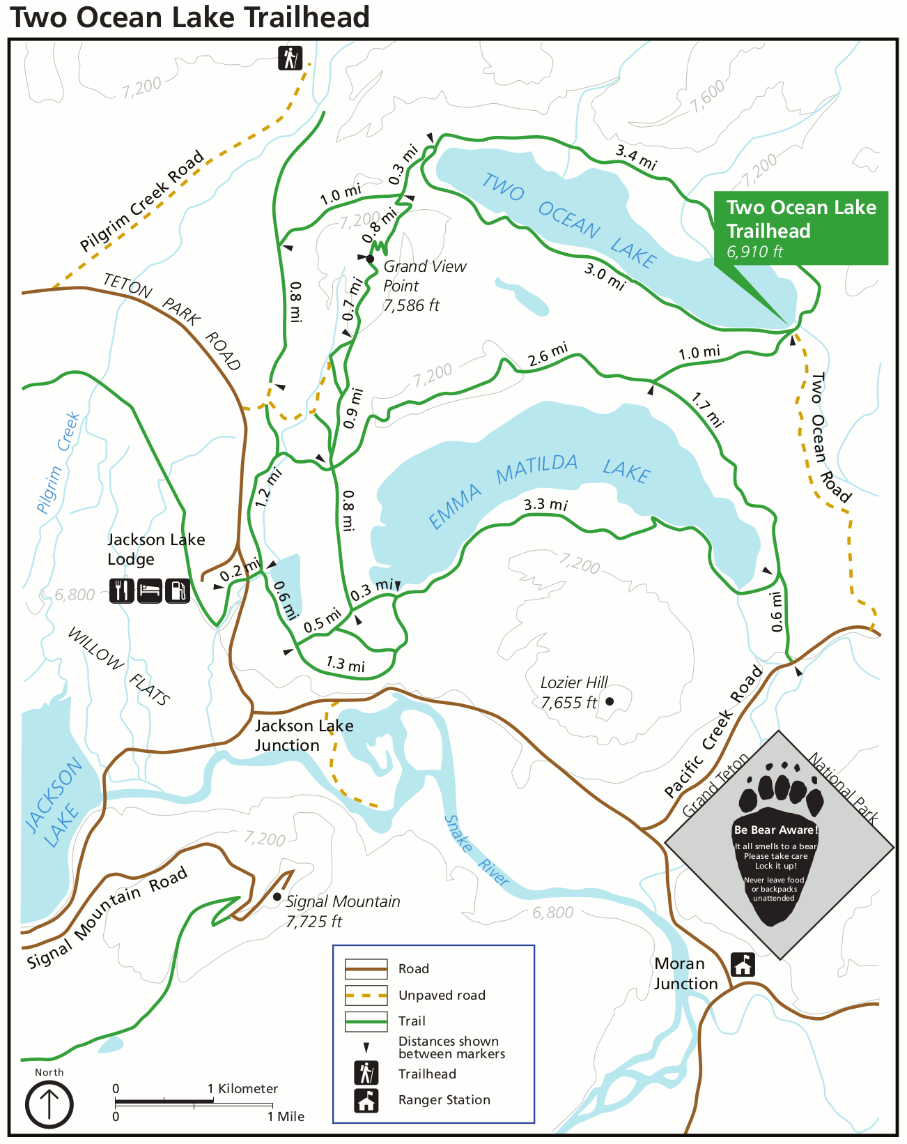 This is a Two Ocean Lake Trailhead map, showing trails around Two Ocean Lake and Emma Matilda Lake, east of the Jackson Lake Lodge. These are flatter lake trails that don’t venture toward the mountains.
 This is a Hermitage Point Trailhead map, showing trails along the eastern shore of Jackson Lake near Colter Bay Village. You’ll see the village, Jackson Lake Lodge, and Signal Mountain Lodge on this map.
Photorealistic Grand Teton maps
 Here’s a 3D Grand Teton National Park map, showing the entire park — much like the main maps above — but in a more three-dimensional art style, showing the mountain ranges better.
 Here’s a Grand Teton trail map, focused on the peaks and trails immediately surrounding Grand Teton and other high mountains, including Cascade Canyon, Paintbrush Canyon, and the Teton Crest Trail.
 This map of the Jenny Lake Visitor Center area is found on a wayside exhibit near the parking lot at the Jenny Lake Visitor Center. It shows the immediate surrounding area, including the boat dock.
Grand Teton lodging map
 The popular resort town of Jackson is located outside Grand Teton’s south entrance and is by far the most popular place to stay. To the right you can open an Expedia interactive Grand Teton lodging map centered on Jackson. But there is also lodging inside the park, so it’s worth zooming out and scrolling to see what strikes your fancy. Or compare reviews of the highest-rated Grand Teton lodging on Expedia.
Grand Teton detail maps
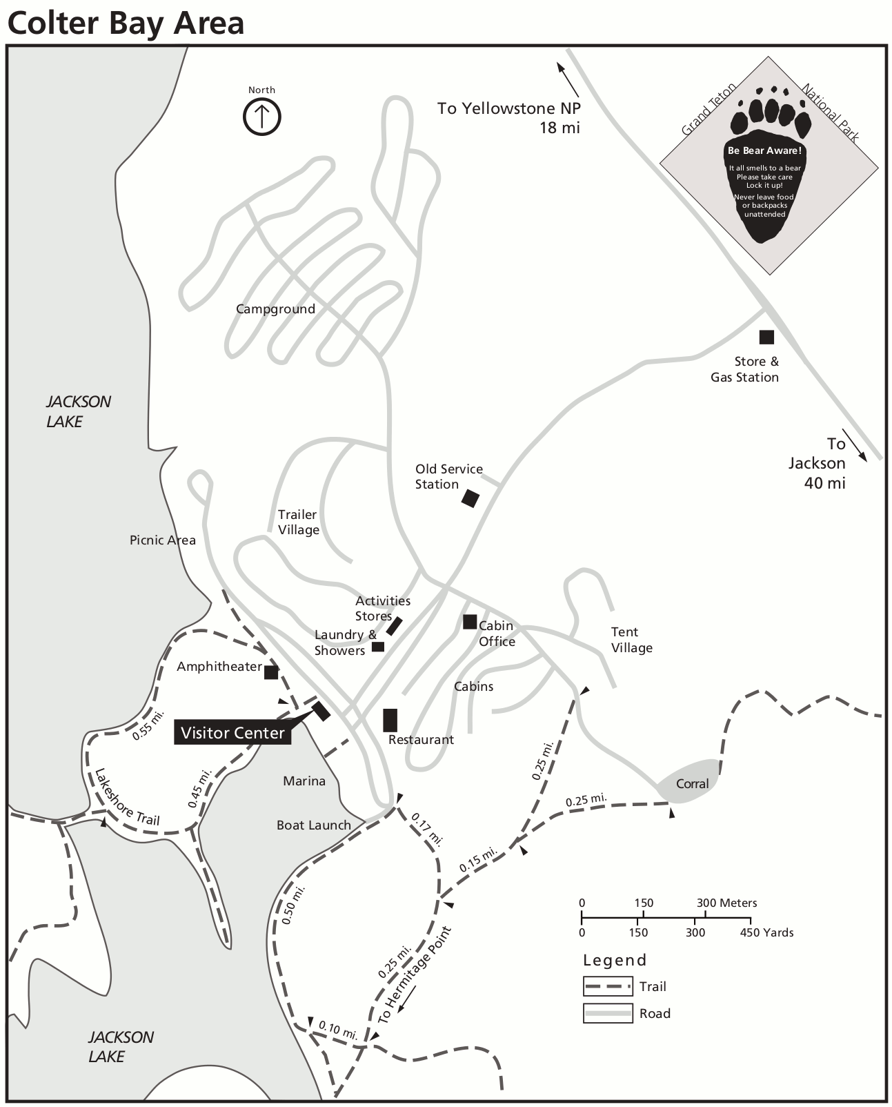 This is a Colter Bay area detail map, centered on the visitor center area to show the campground, marina, stores, showers, picnic areas, gas station, and other services.
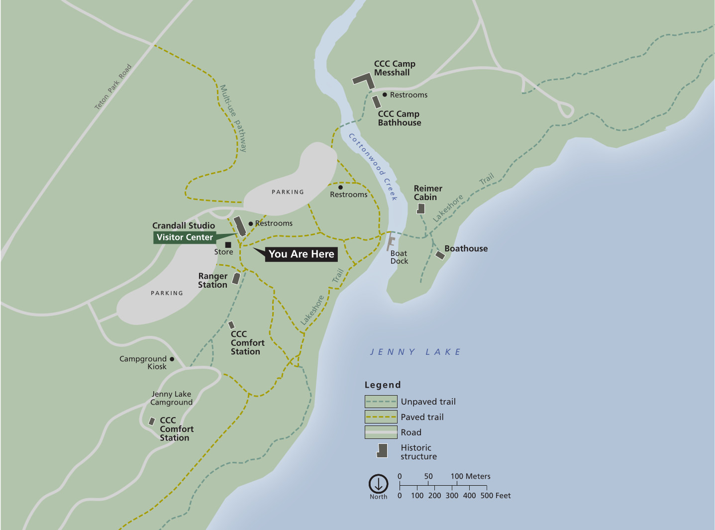
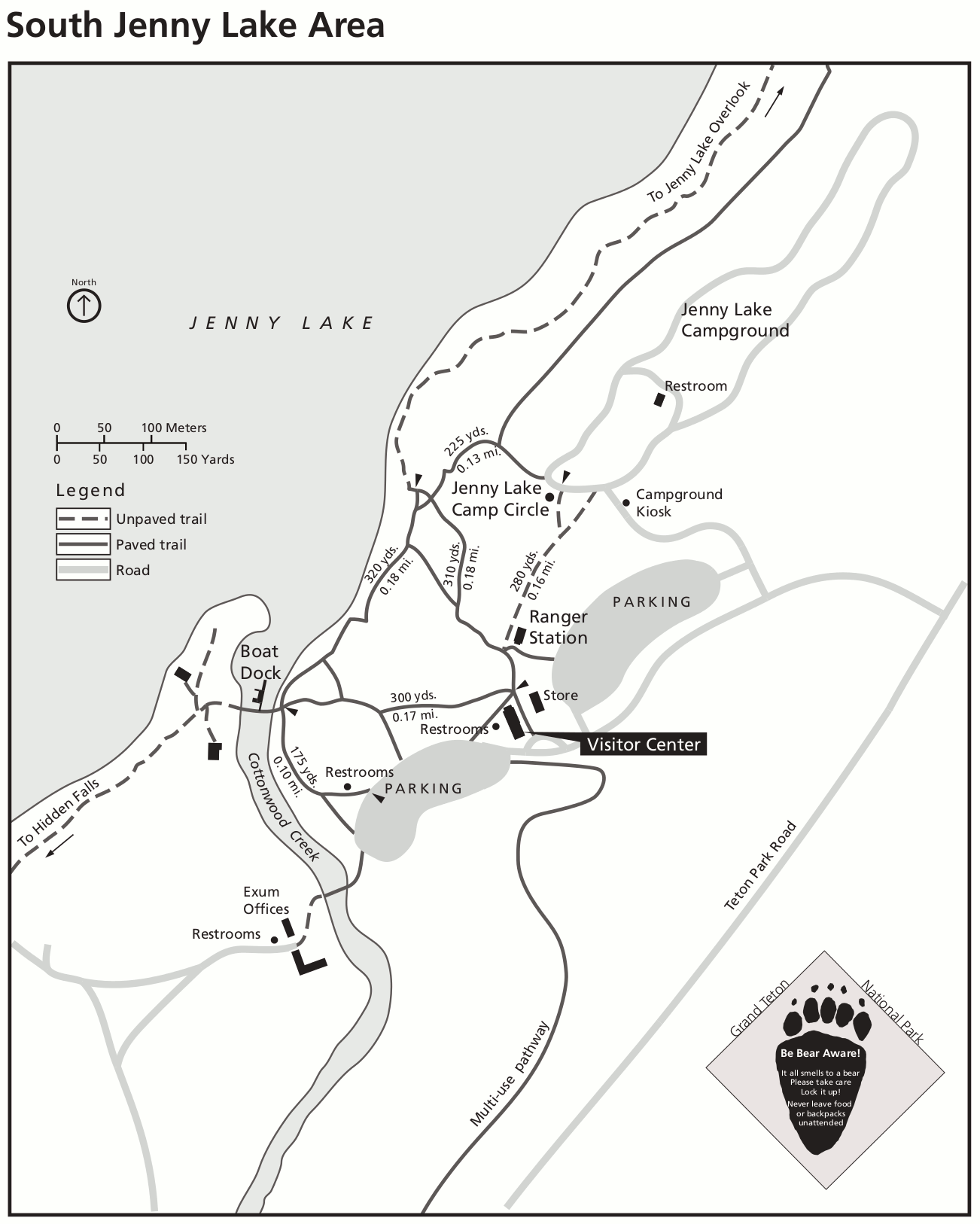 This is a Jenny Lake map, zooming in on this popular area of Grand Teton National Park. Here you’ll see the visitor center, boat dock, campground, restrooms, and the various trails that depart from here.
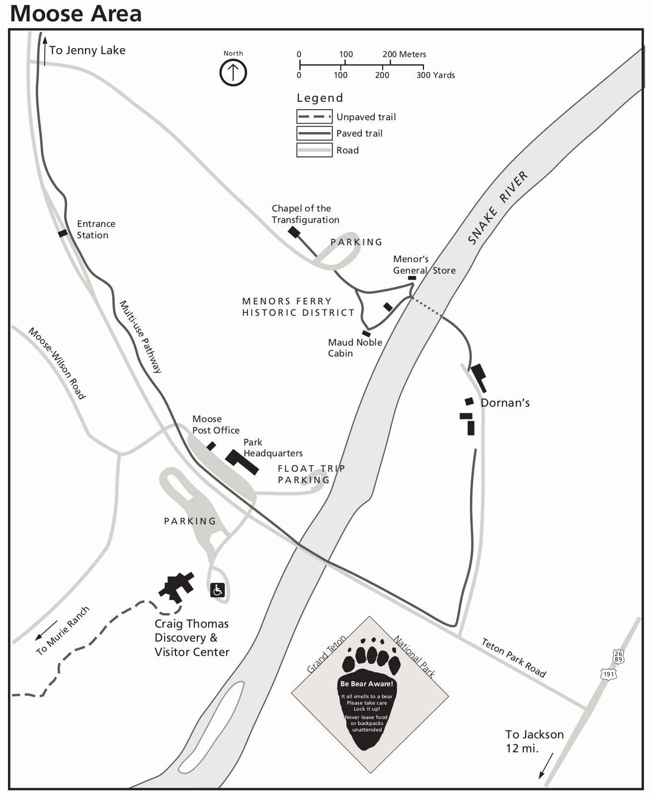 Here’s a Moose area detail map, where the Teton Park Road intersects 191. You’ll see labels for the visitor center, park headquarters, parking, and the historic district along the Snake River.
Grand Teton winter maps
 This is a winter map of Grand Teton National Park, showing which roads and trails are open and closed during the winter, and whether they’re at least open for non-motorized use.
 The Moose-Wilson Road winter map is the southernmost of these maps; therefore it is the closest to Jackson (where you are probably staying). The following maps are to the north.
 Here’s a Taggart Lake winter map, showing the ski and snowshoe routes up to Jenny Lake from the end of the plowed road at the Taggart Lake trailhead. The road continues north for winter recreation only.
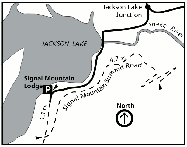 This Signal Mountain winter map focuses on the Signal Mountain summit road, open for winter recreation from the parking area at Signal Mountain Lodge, south of the Jackson Lake junction.
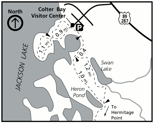 The Colter Bay winter map shows the various winter trails toward Heron Pond and Swan Lake, along the shores of Jackson Lake in the northern part of Grand Teton National Park.
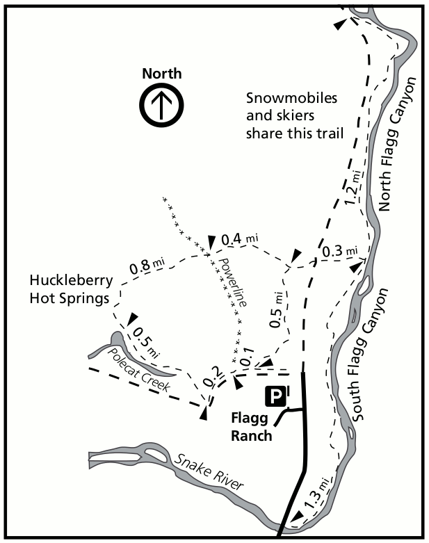 This Flagg Ranch winter map shows the northern end of the road, including winter recreation trails to Huckleberry Hot Springs as well as the winter snowmobile road into Yellowstone.
Assorted Grand Teton maps
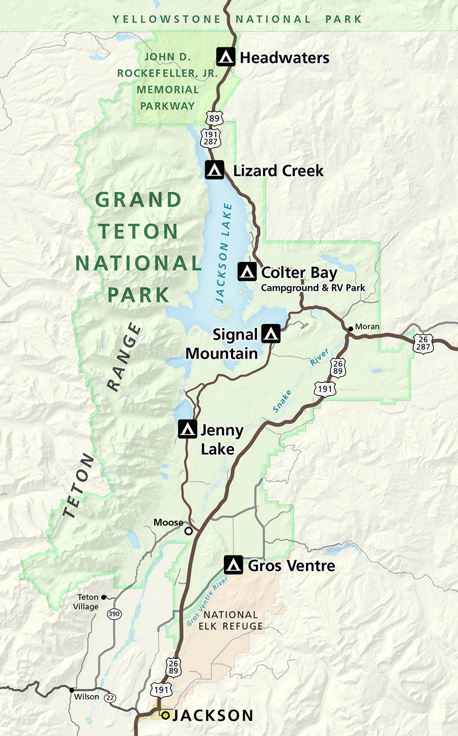 This is a Grand Teton campground map, showing the locations of all campgrounds located within the boundaries of Grand Teton National Park and the neighboring John D. Rockefeller, Jr. Memorial Parkway.
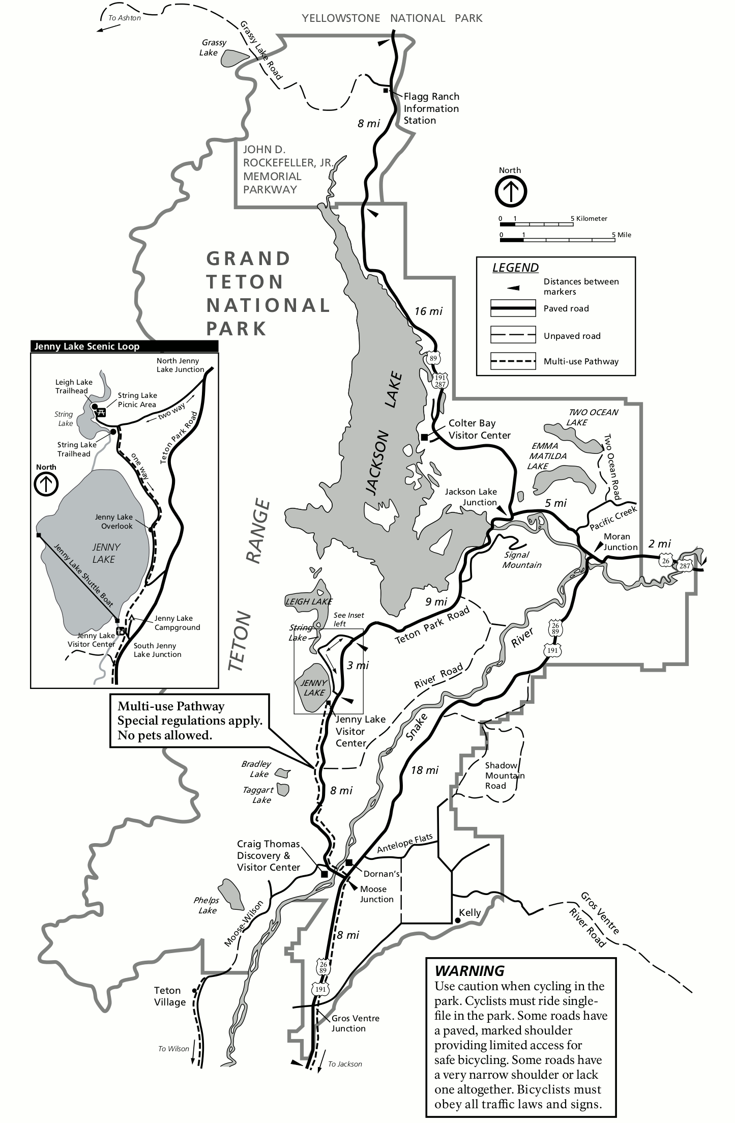 Here’s a Grand Teton bicycle map, showing biking routes and mileages on paved and unpaved park roads. This map includes an inset showing the Jenny Lake area, which is always busy and popular.
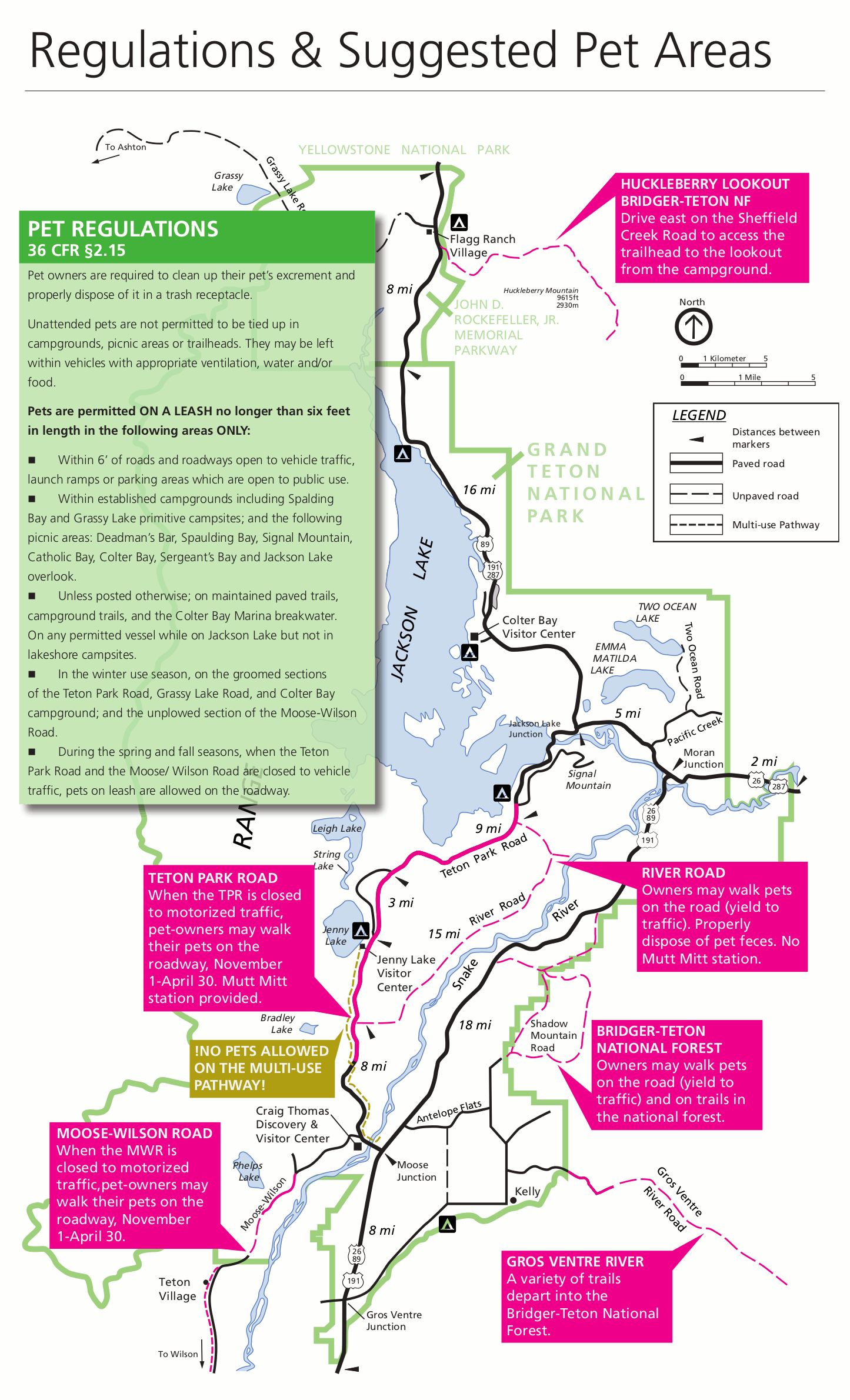 This is a pet-accessible trail map. Generally pets are permitted in national forest land but not on national park trails, so this map is handy to find where you can go with your dog.
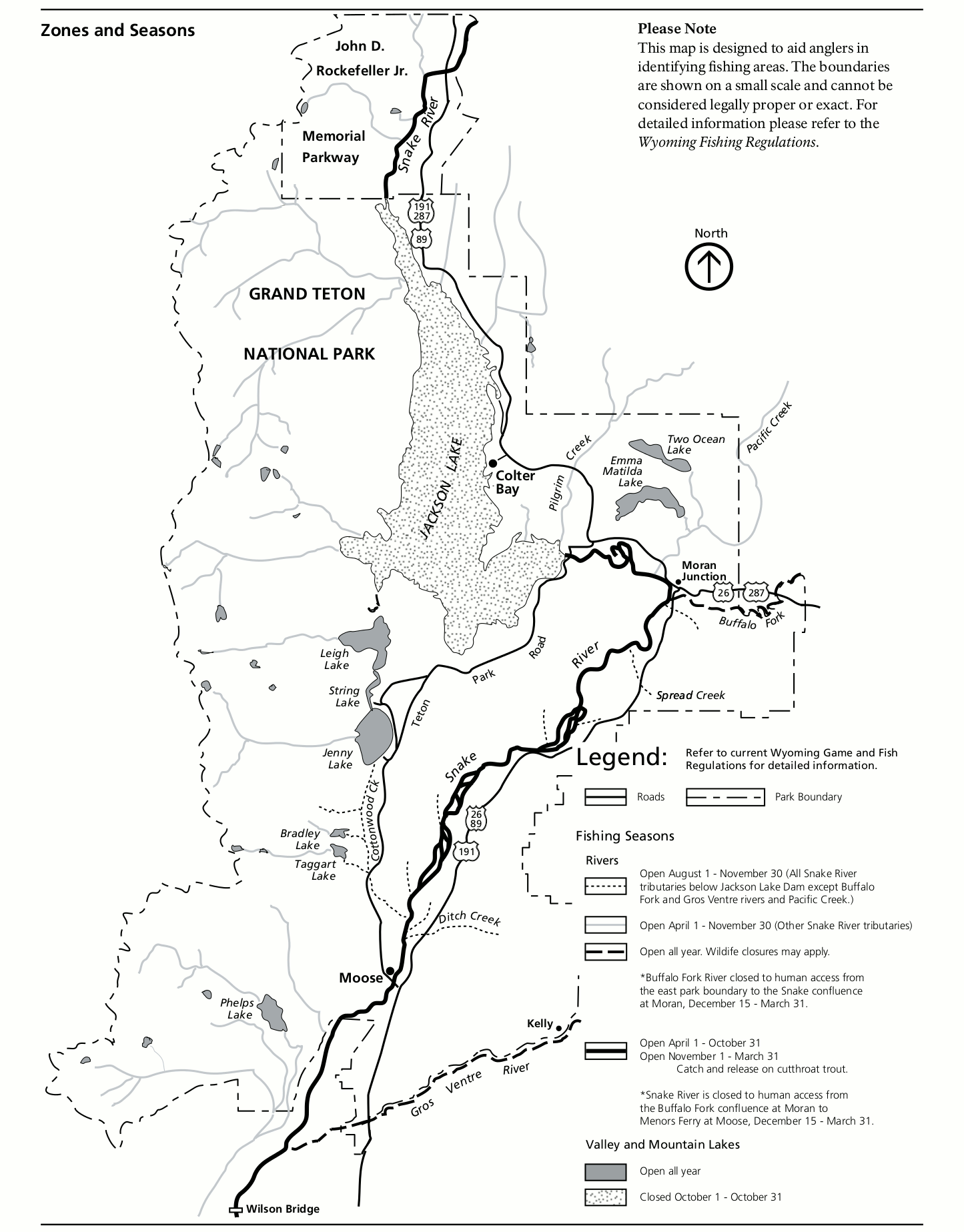
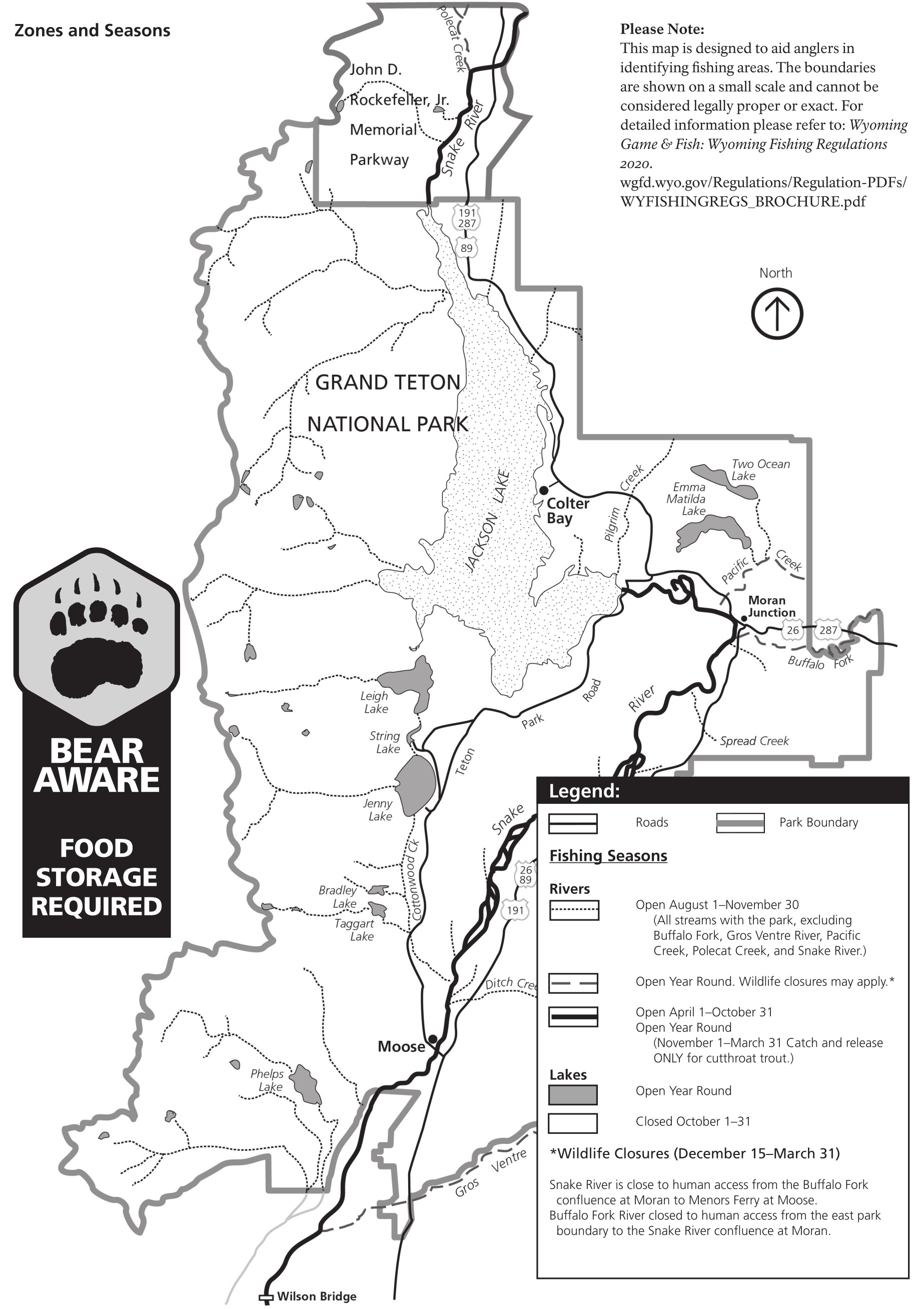 This Grand Teton National Park fishing map was last updated in 2020. The park has some distinct fishing seasons depending on what river or lake you’re on, so this map will help you stay within regulations.
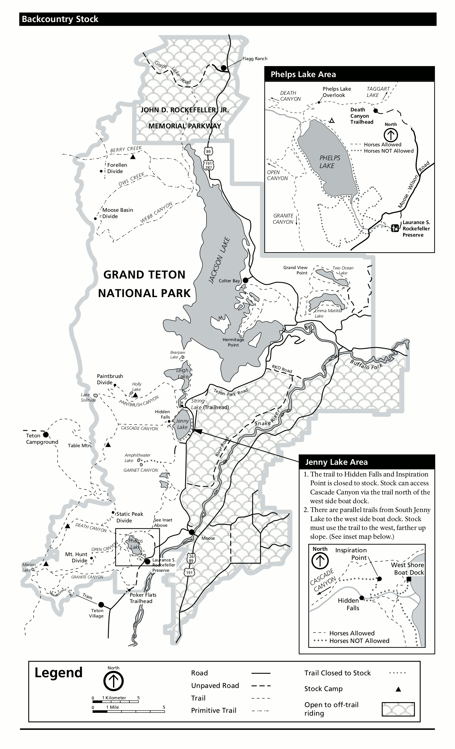 This is a Grand Teton stock trail map, including inset maps for Jenny Lake and Phelps Lake. Here you can see which trails are open and closed to stock use, and where you can do off-trail riding on your horse.
Grand Teton backcountry camping maps
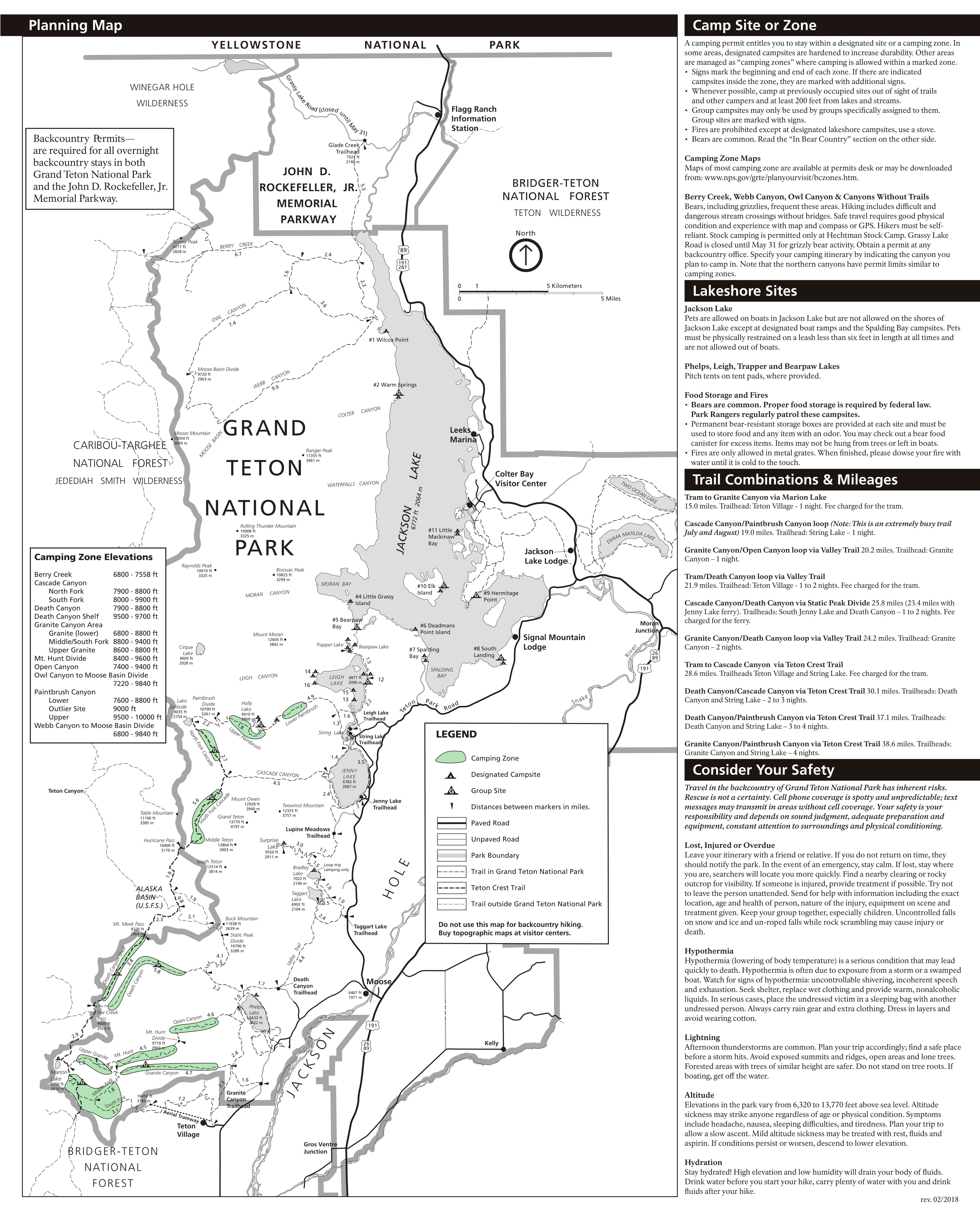 The Grand Teton National Park trail map shows all park trails. It’s especially useful for planning backpacking trips, as it includes all designated backcountry campsites, camping zones, and trail distances.
The maps posted below all show different backcountry camping zones, which are the designated sites for backpackers to set up camp. The National Geographic Trails Illustrated map shows where each of these zones is located on the Grand Teton trail system, and is a must-have because it shows topo lines, distance labels, and considerably more trail detail than any free map I’ve been able to find. Don’t go backpacking without a map like this.Central Tetons
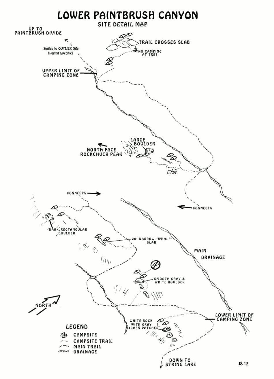 This is the Lower Paintbrush camping zone, located upstream (west) of Leigh Lake in Paintbrush Canyon (in between Cascade Canyon and Leigh Canyon). Continue up the trail to the two camping zones below.
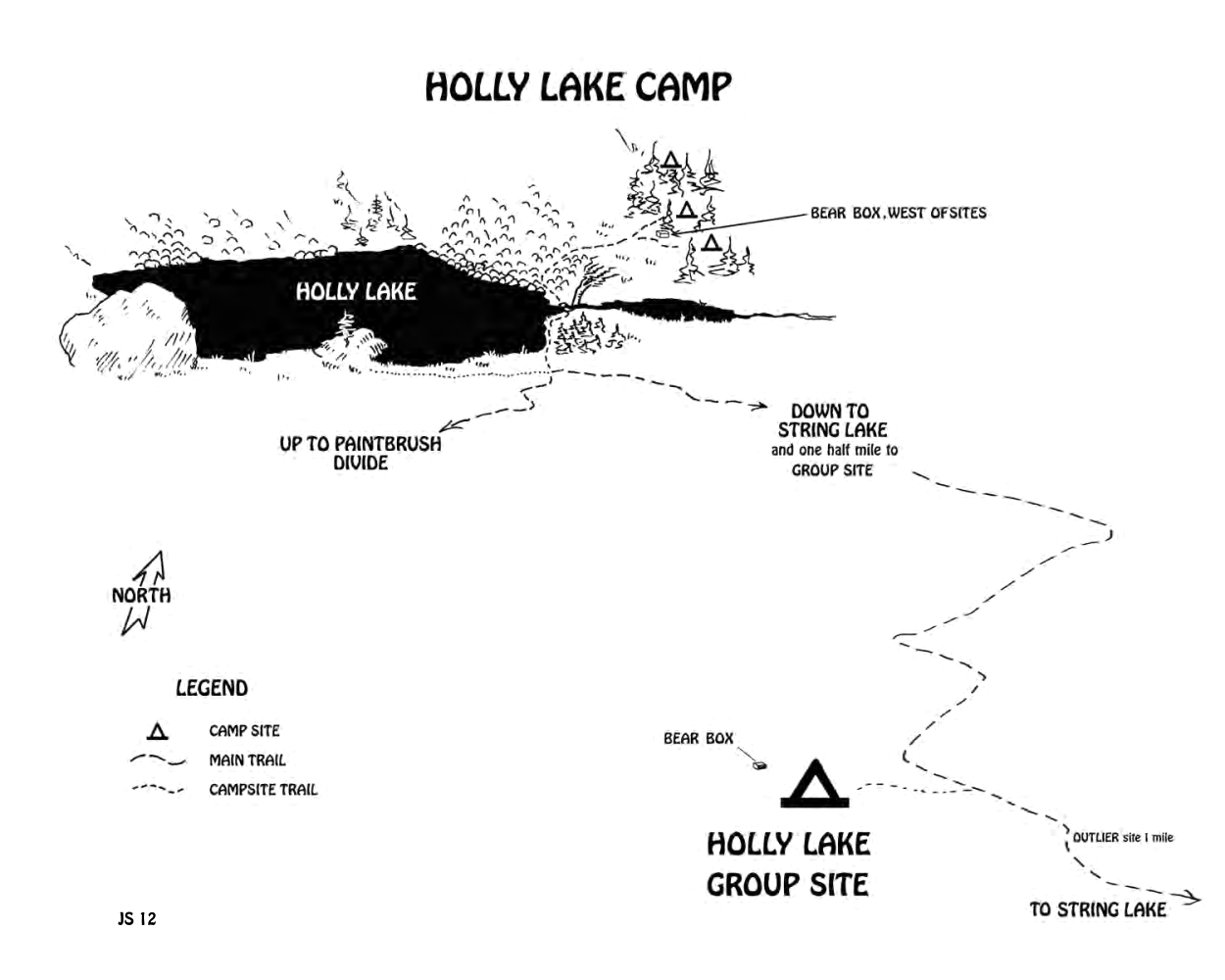 This is the Holly Lake campsite, located near the Upper Paintbrush backcountry camping zone southwest of Leigh Lake. This is a separate camping area from Upper Paintbrush zone.
 This is the Upper Paintbrush camping zone, located upstream (west) of the Lower Paintbrush Zone in Paintbrush Canyon. It’s near Holly Lake. This is an open camping area where you can choose your own site.
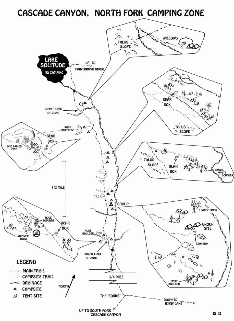 This is the North Fork of Cascade Canyon camping zone, located in the headwaters of Cascade Creek upstream of Jenny Lake. This zone is over Paintbrush Divide from Holly Lake.
 This is the South Fork of Cascade Canyon backcountry camping zone, located in the Cascade Creek headwaters just west of the main Teton mountain peaks and below Hurricane Pass.
 This is the Garnet Canyon camping zone, located just east of the Tetons and commonly used among mountain climbers. There are actually several camping areas located within this single camping zone.
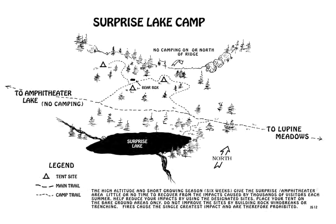 This is the Surprise Lake campsite, located east of the Tetons and usually accessed through the Lupine Meadows trailhead. Here there are specific sites to camp in, rather than the dispersed zones above.
Southern Tetons
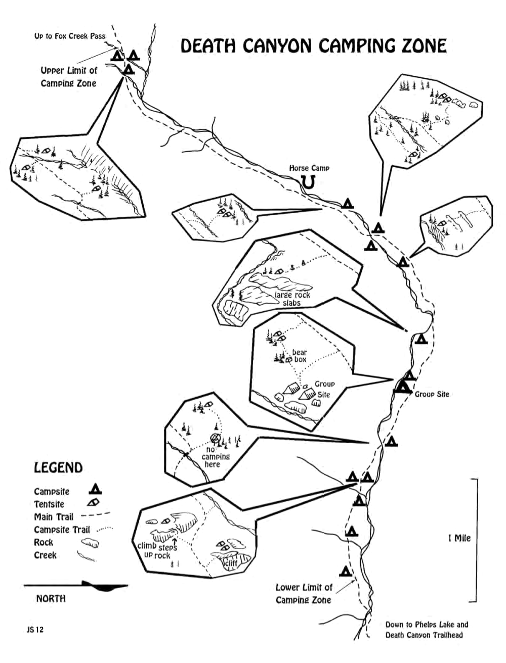 This is the Death Canyon camping zone, located in Death Canyon west of Phelps Lake in the southern section of the park. You’ll find several distinct camping areas throughout the canyon.
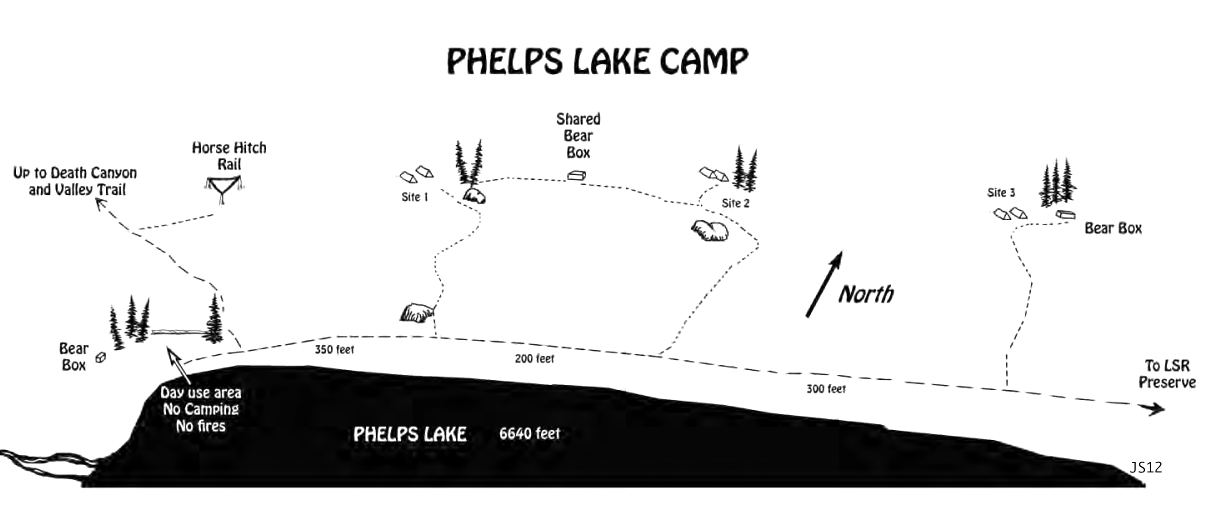 This is a map of the Phelps Lake campsite, located east of Death Canyon and Open Canyon in the southern Grand Tetons. These are individual campsites, in contrast to the dispersed zones found elsewhere.
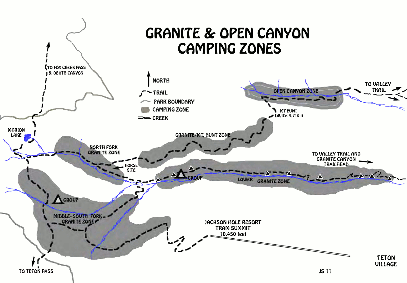 This map shows the five camping zones in Granite Canyon and Open Canyon, surrounding Mount Hunt in the southern Tetons. This is in the southern part of the national park, close to Teton Village.
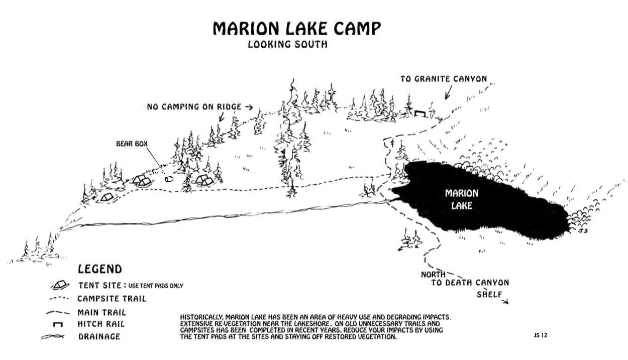 This is a map of the Marion Lake campsite, located in the headwaters west of Granite Canyon in the southwest corner of the park. Camping is only permitted on the provided tent pads.
Grand Teton science maps
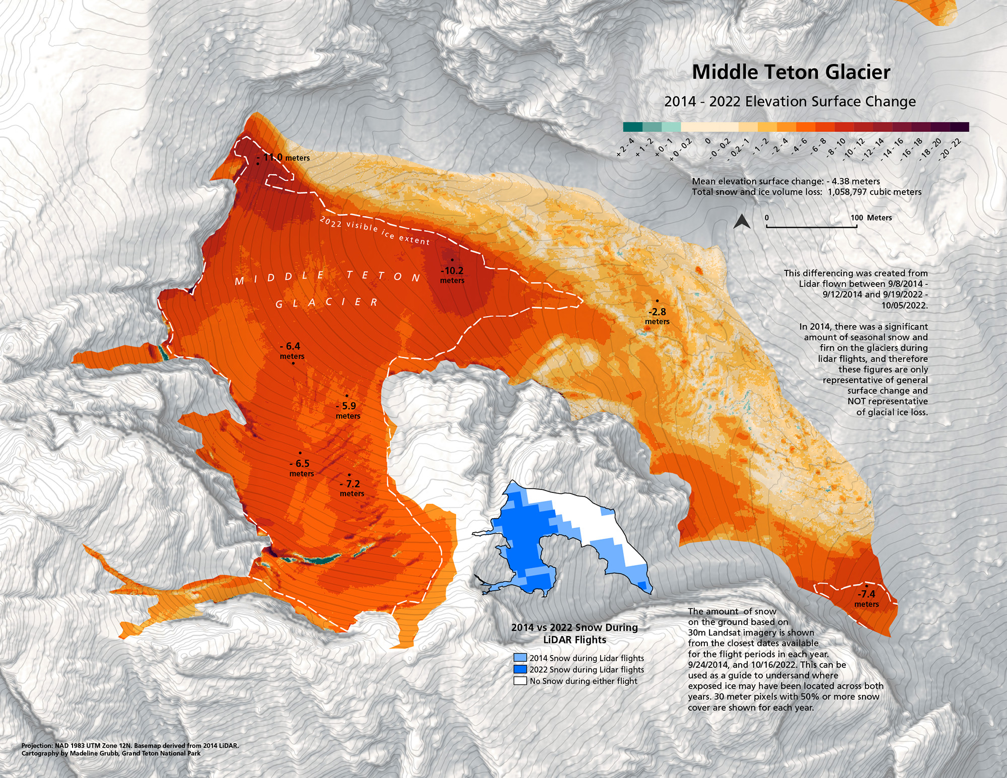 The Middle Teton Glacier retreat map visualizes how rapidly the Middle Teton Glacier is disappearing. This map shows the change of extent and surface elevation from 2014 to 2022. The glacier is even smaller today.
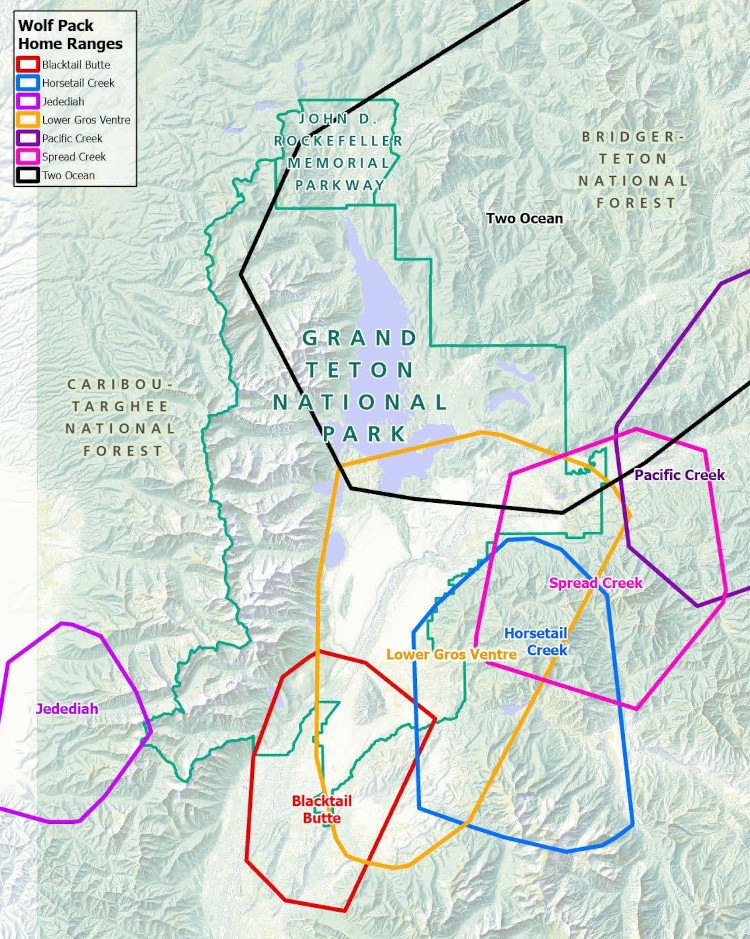 This is a 2024 wolf range map that shows the general ranges of gray wolf packs in the year 2024 in the Jackson Hole area. They descended from the wolves originally introduced in Yellowstone in the mid-1990s.
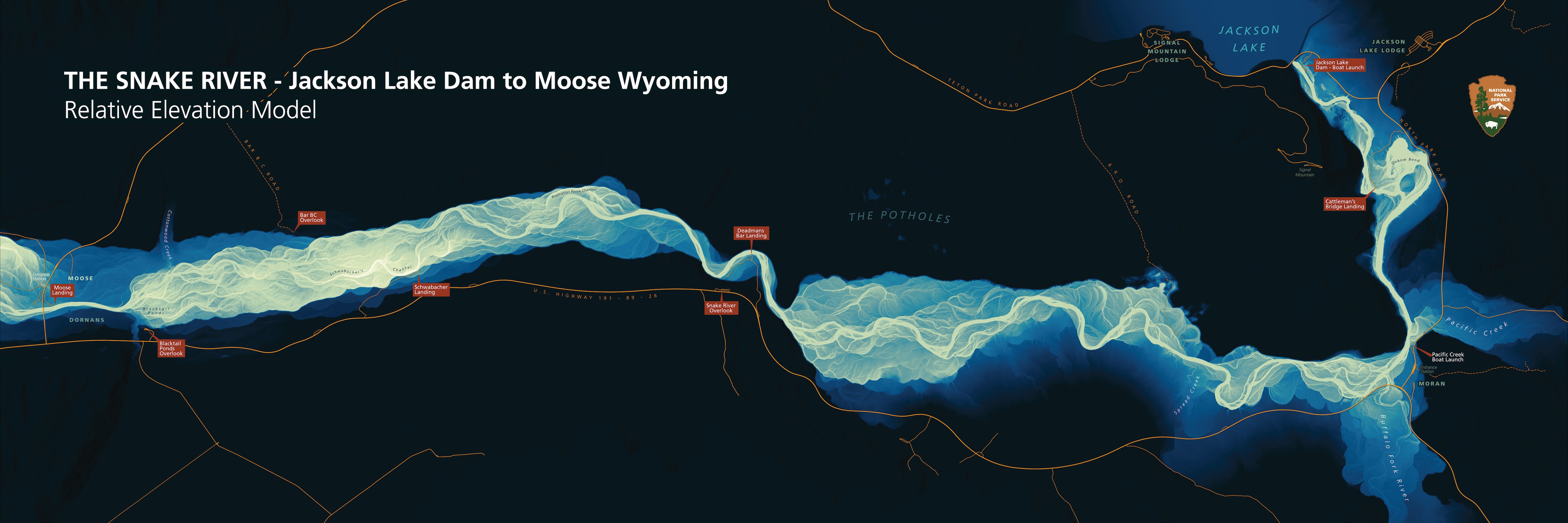 The Snake River elevation map shows the relative elevation of the Snake River streambed and river-adjacent lands through Grand Teton National Park. Data was captured with LiDAR technology.
 Here’s a huge and beautiful Teton Fault map. Credit: Zellman, M.S., DuRoss, C.B., and Thackray, G.D., 2019, The Teton fault: Wyoming State Geological Survey Open File Report 2019-1, scale 1:75,000.
 This enormous Grand Teton geologic map shows the incredibly complex geology of Grand Teton National Park – geology nerds like me will enjoy savoring this one. (Note the large file size.)
 This geologic map of Grand Teton is an overview of the two digitally-based geologic maps below, including a legend identifying each rock type. The individual geologic maps below do not include legends.
 Here’s a north Grand Teton geologic map, focusing on the northern part of Grand Teton National Park (including Jackson Lake and the northern Teton Range) up to where it intersects with Yellowstone.
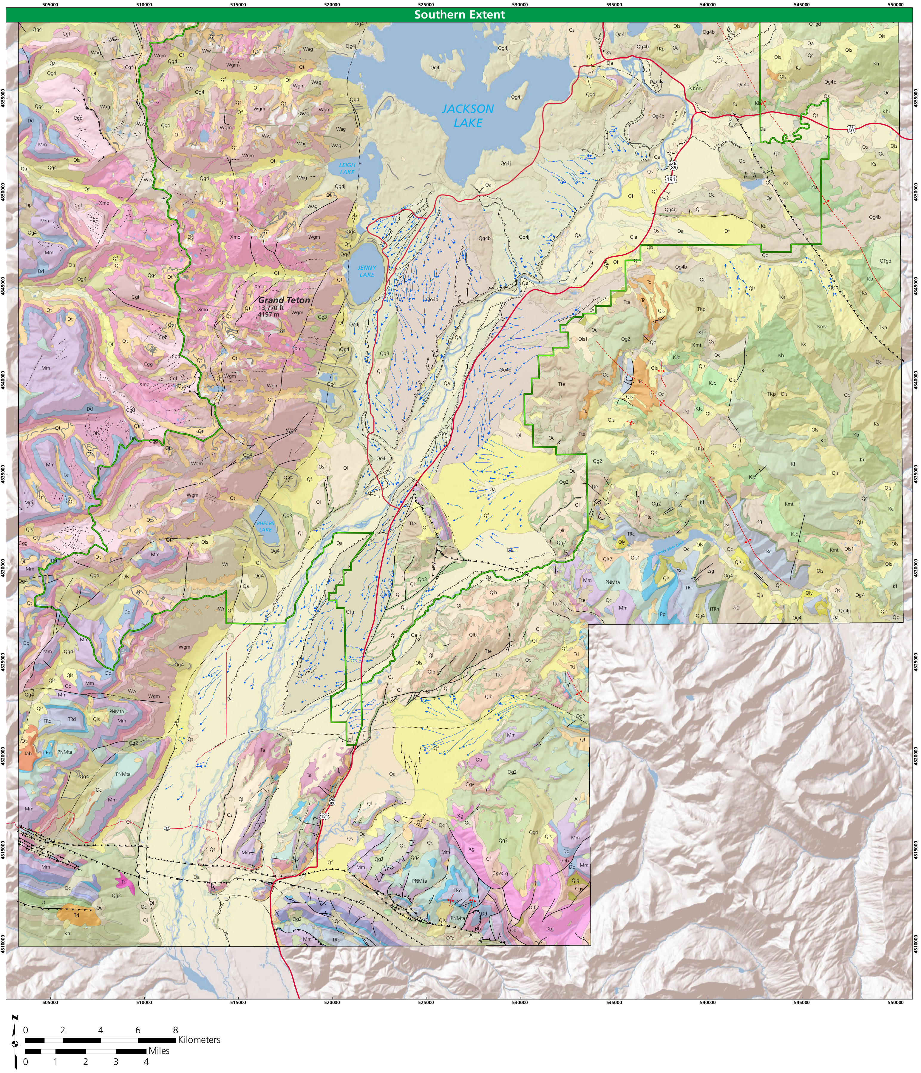 The south Grand Teton geologic map shows the area of the park that includes Jenny Lake, Grand Teton, and the northern part of Jackson Hole, where you’ll find the city of Jackson.
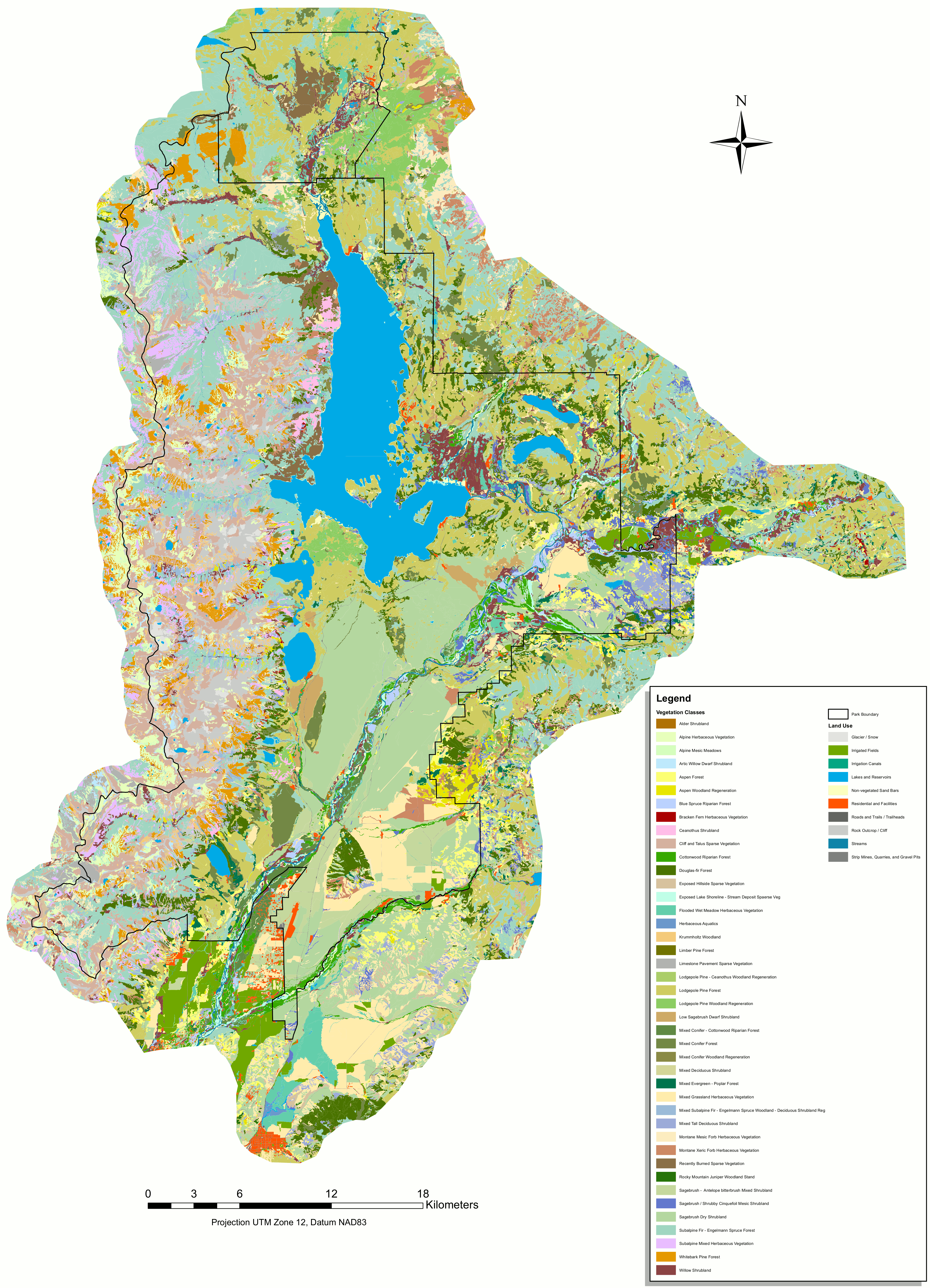 This vegetation map of Grand Teton National Park includes the park’s plant communities while also mapping locations where no plants grow, such as rock and ice (found at the higher elevations).
Grand Teton historic property maps
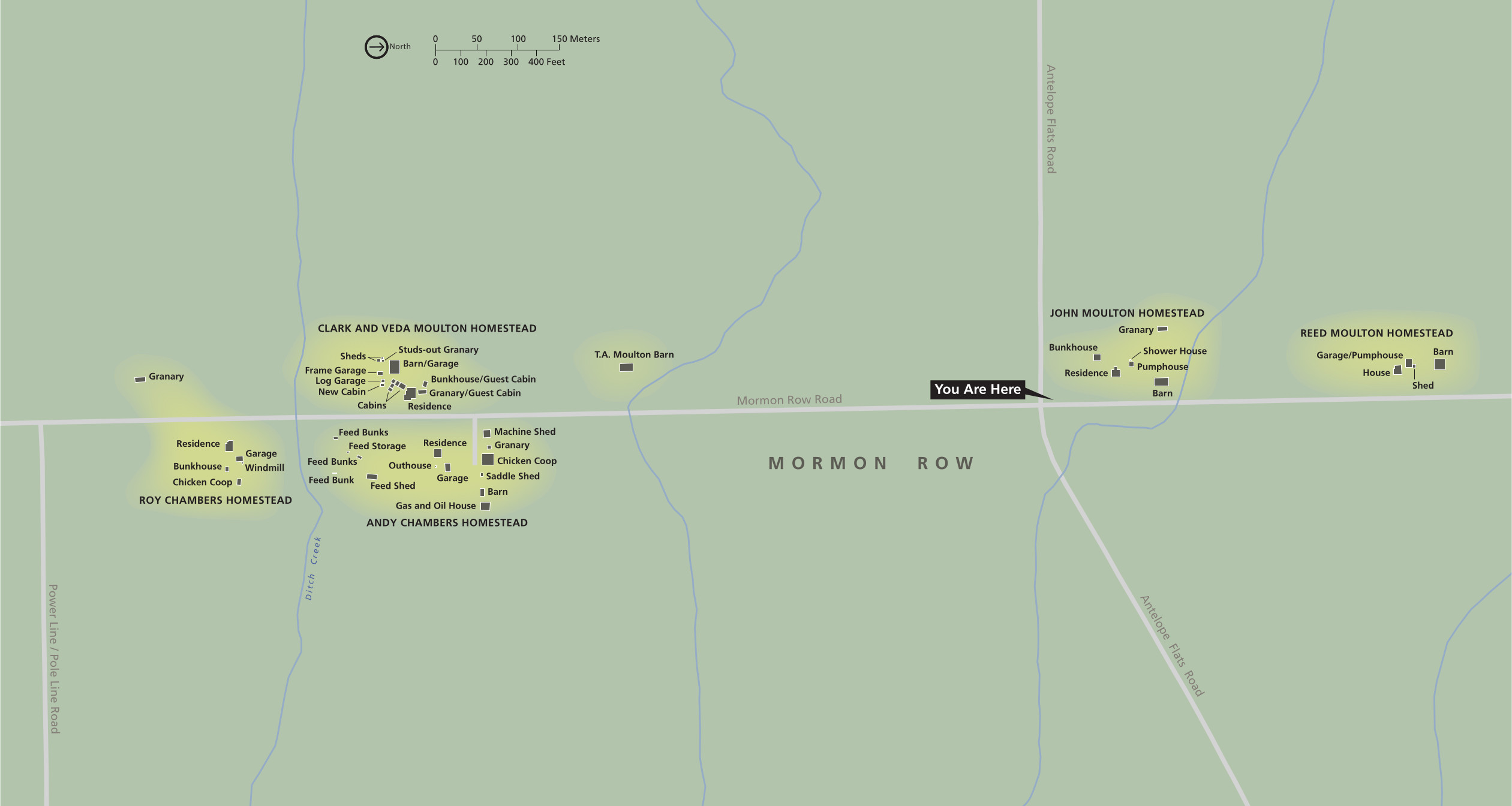 The Mormon Row map shows the iconic historic structures of the Mormon Row Historic District, so common in foreground shots of the Tetons. Click the image to view a full size map or download the PDF.
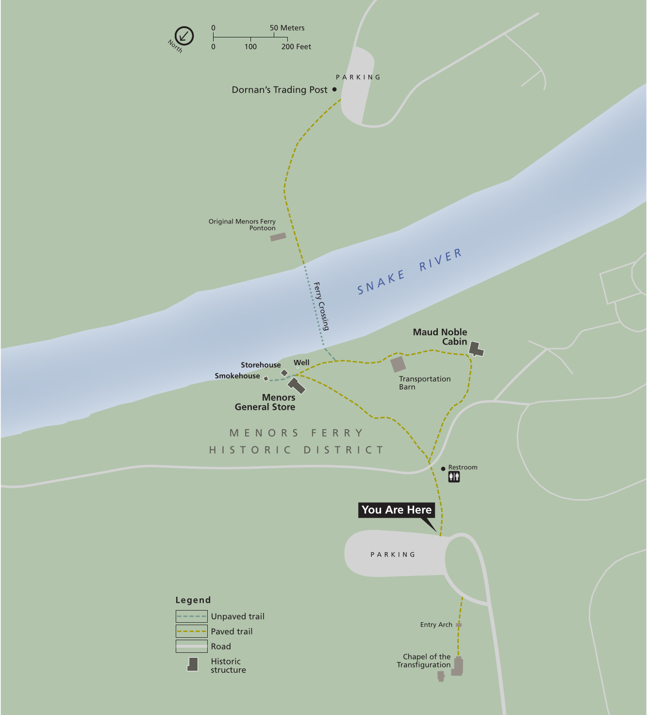 This is a Menors Ferry map, zooming in on the Menors Ferry Historic District, located across the Snake River from Dornans, near the Moose entrance. Click the image to view a full size map or download the PDF.
 The Jenny Lake Historic District map focuses on the historic structures in the immediate area around the Jenny Lake Visitor Center. Click the image to view a full size map or download the PDF.
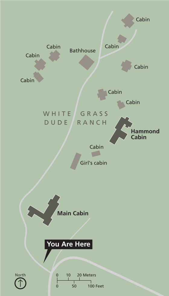 Here’s a White Grass Dude Ranch map, located near the Death Canyon Trailhead off the Moose-Wilson Road. Click the image to view a full size map or download the PDF.
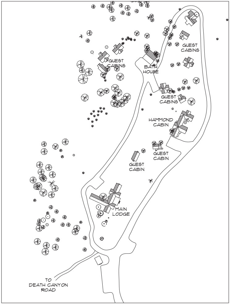 This is another White Grass map, this one in black-and-white and showing much more detail about the structures and trees that make up this historic landscape in the southern part of the park.
 The Bar BC Dude Ranch map shows this historic landscape located down the River Road, which is recommended for four-wheel-drive vehicles only. Click the image to view a full size map or download the PDF.
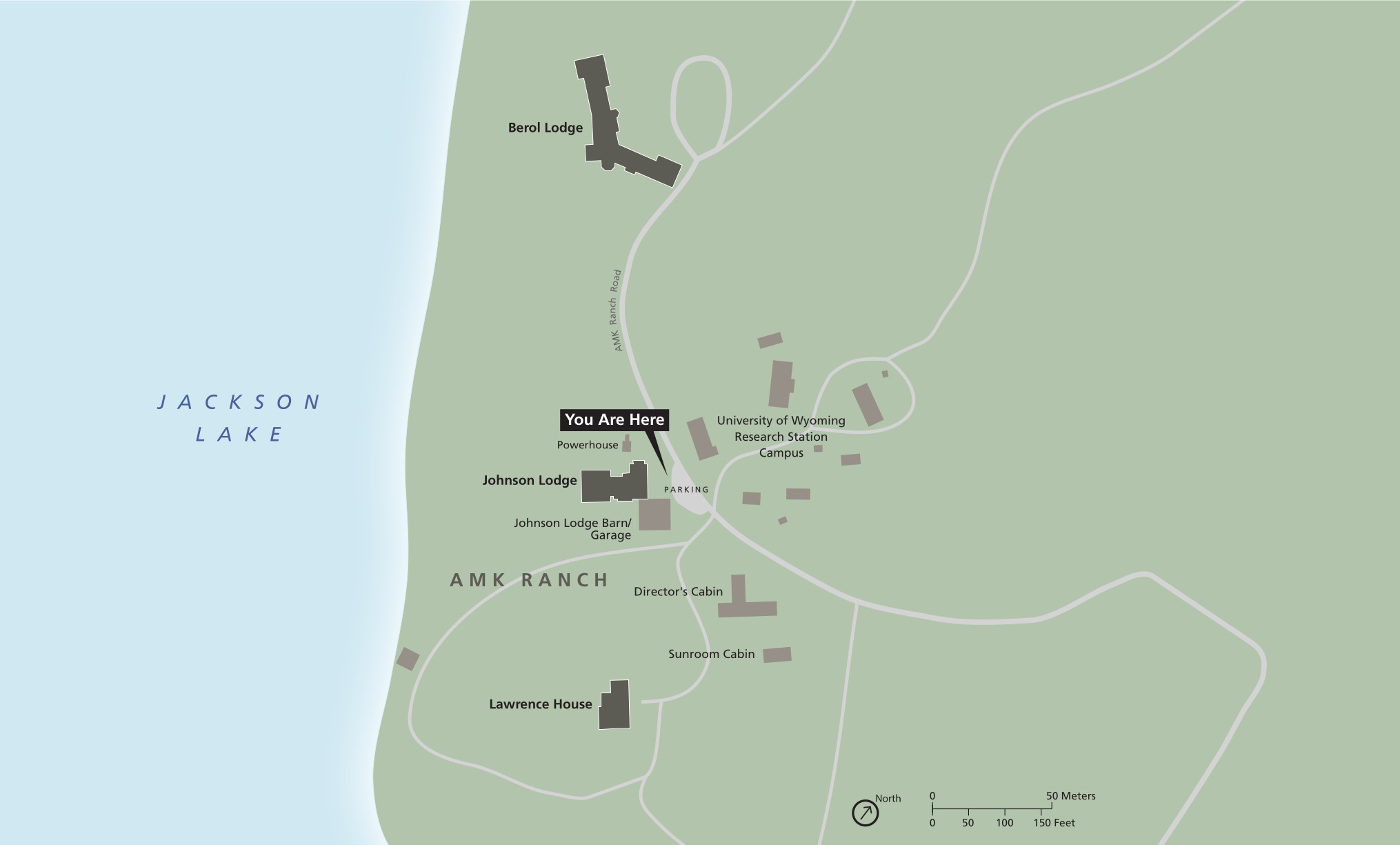 This AMK Ranch map shows structures of the former ranch, which is now used as a University of Wyoming research station to house researchers. Click the image to view a full size map or download the PDF.
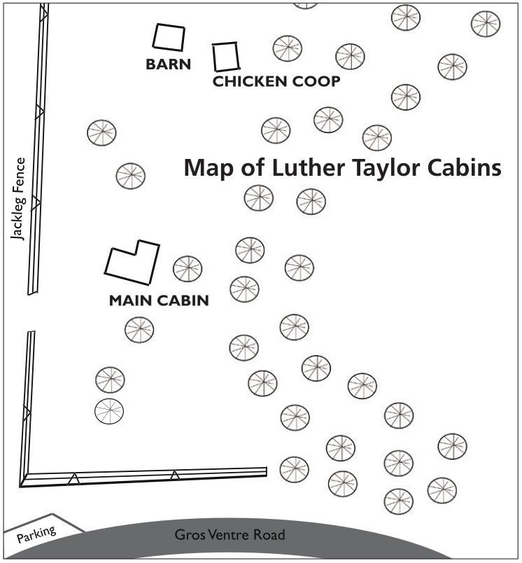 This is a Luther Taylor Cabins map. These structures became famous as a backdrop during the 1951 classic western film, Shane. You can reach these by driving down the Gros Ventre River Road.
Archived Grand Teton maps
The maps below have since been superseded by the map on top of this page, but I’ve provided them here for archival purposes, as I believe it’s important to be able to see how parks change over time. It’s also to ensure any links or references to these maps from around the web remain valid and intact.
 This was the main Grand Teton map from the official brochure in the mid-2010s, showing the roads, trails, lakes, visitor centers, and points of interest. Click the image to view a full size map or download the PDF.
 This is an even older Grand Teton map, which I think is a bit easier to read when printing since it’s not so heavily shaded. Click the image to view a full size map or download the PDF.
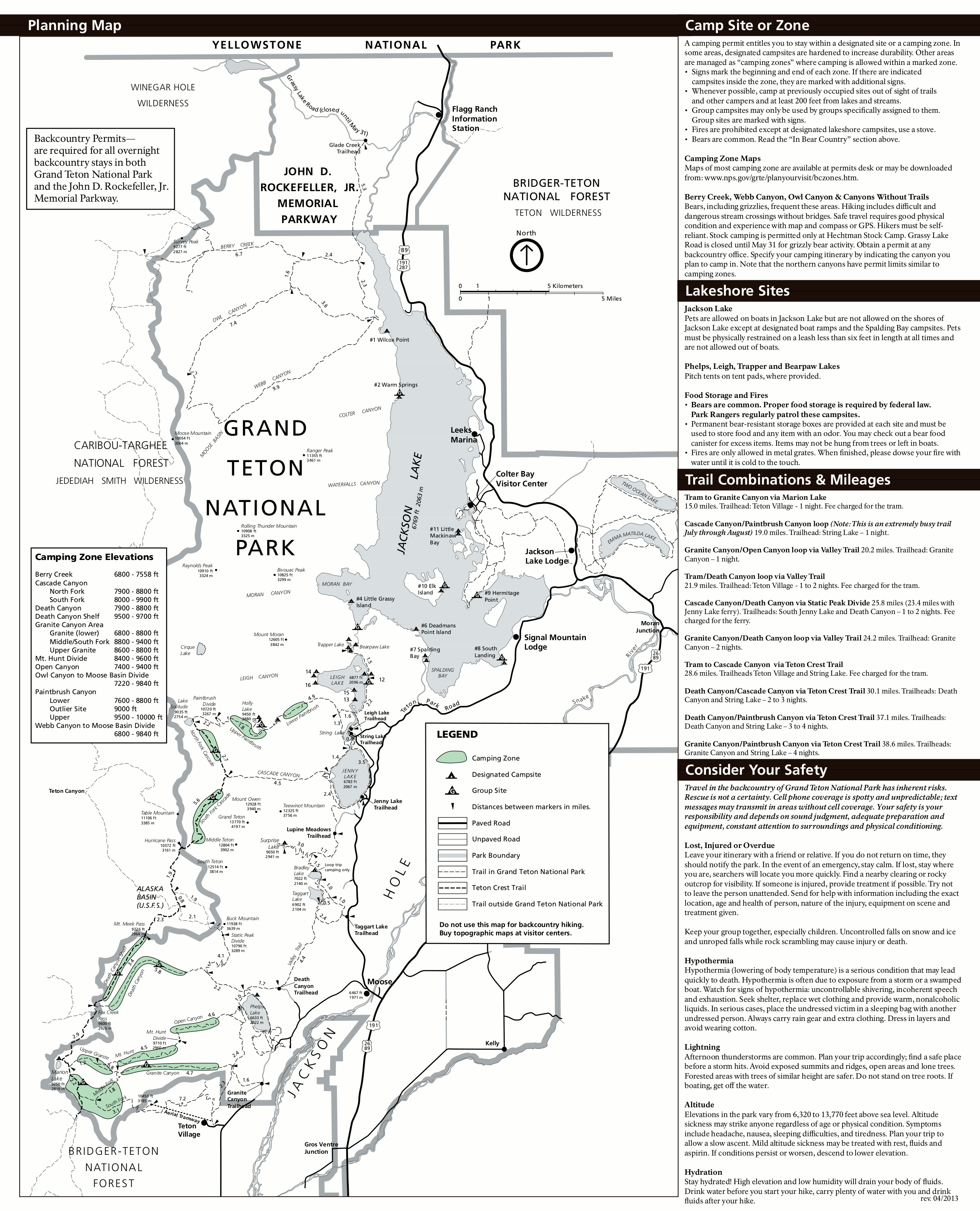 This is an old map of Grand Teton’s backcountry trails and trail mileages from 2013. It also shows backcountry camping zones (scroll to detailed camping zone maps near the bottom of this page).
 This is an old Flagg Ranch Trailhead map, showing trails along the Snake River in the far northern part of Grand Teton National Park as you make your way to or from Yellowstone.
 This is an old Grand Teton fishing map from the mid-2010s, showing the fishing seasons for lakes, rivers, and streams in the Grand Tetons. Each water course is labeled with its fishing regulations and season.
Grand Teton map prints and gifts

 Printed high-resolution Grand Teton map posters and other products are available at the Grand Teton Maps store. For prints, gift ideas, and souvenirs featuring other national parks, support this site and visit the National Park Maps store; you’ll find items to bring on vacation, keep at home for the memories, or give to your park-enthusiast friends and loved ones.
…and more!
< Return to National Park Maps home
< Return to Park List
< Return to List by State