The National Park Service manages a number of national trails that extend beyond individual state lines. This page has official park brochure maps for many of these trails: enjoy! Note that trail map PDF files will open in a new window (and some are very large).
National trails map
 Here you’ll find the official national trails map, showcasing the variety of trails managed by the National Park Service, including National Scenic Trails and National Historic Trails. You’ll find detailed maps of many of these trails if you scroll down on this page. Click the image to view a full size JPG (2.7 mb) or download the PDF (28.1 mb). (Note the large file size on the PDF; it will take some time to download!)
Appalachian Trail map
 The Appalachian Trail map shows the entire length of the world famous Appalachian National Scenic Trail. Beginning in Springer Mountain, GA and ending on the summit of Mt. Katahdin in Maine, the Appalachian Trail traverses 2,200 miles of the best mountain scenery of the eastern United States. Just don’t expect your hike to come with solitude! Click the image to view a full size GIF (2.9 mb) or download the PDF (2.0 mb).
California Trail map
 This is a California National Historic Trail map, showing the network of trails that led west to California across the U.S. frontier. The eastern section followed the route of the previously-established Oregon Trail before splitting off for the gold prospects and farmland of California. Over 200,000 emigrants made this journey, including the remnants of the ill-fated Donner Party. Click the image to view a full size JPG (2.8 mb) or download the PDF (8.5 mb).
Lewis and Clark Trail map
 Here you’ll find a Lewis & Clark National Historic Trail map. This map highlights both the outbound and return journeys of Lewis and Clark, including where they differed on the return. Roads that are part of the official driving route are also shown, as are the historical territories of Native American Indian tribes (and their present-day reservation locations). Click the image to view a full size GIF (1.2 mb) or download the PDF (10.1 mb).
Mormon Trail map
 Here’s a map of the Mormon Trail, now preserved by the National Park Service as the Mormon Pioneer National Historic Trail. The map traces the pioneer route from Nauvoo, IL to Salt Lake City, UT, mostly following the Oregon Trail. Especially helpful on this map are the text descriptions explaining major events and points of interest along the way. Click the image to view a full size GIF (1.6 mb) or download the PDF (500 kb).
Natchez Trace map
 The Natchez Trace National Scenic Trail map shows the five separate trail sections — totaling about 60 miles — that make up the foot-trail section of the Natchez Trace. This trail is administered by the Natchez Trace Parkway, which allows you to follow the old Trace route by road. View the dozens of additional maps on the Natchez Trace maps page here on NPMaps. Click the image to view a full size JPG (1.2 mb) or download the PDF (2.2 mb).
New Jersey Coastal Heritage Trail map
 Here’s a trail map of a different kind: the New Jersey Coastal Heritage Trail Route map. This is an auto trail connecting 300 miles of New Jersey coastline, with an emphasis on history, wildlife, and scenic beauty (yes, in New Jersey!) It extends from the Sandy Hook area near Gateway National Recreation Area in the north toward Cape May in the south. Click the image to view a full size JPG (350 kb) or download the PDF (1.3 mb).
Oregon Trail map
 This Oregon Trail map shows the grandaddy of them all: the Oregon National Historic Trail. Various trails followed the eastern portion of this route, including the California and Mormon trails. Although more emigrants used this trail to reach California than Oregon, the original route to Oregon was established first and is arguably of more historical significance. Click the image to view a full size JPG (3.0 mb) or download the PDF (25.1 mb).
Overmountain Victory Trail map
 Here’s an Overmountain Victory National Historic Trail map. No, you haven’t heard of it? The Overmountain Victory Trail preserves the route taken by the Overmountain Men, frontiersmen from “over the mountain” (west of the Appalachian range) who fought during the Revolutionary War. This map shows their route, leading to victory at Kings Mountain, SC. Click the image to view a full size JPG (1.9 mb) or download the PDF (8.6 mb).
Pony Express trail map
 This is a Pony Express map, a route protected today by the National Park Service as the Pony Express National Historic Trail. Mail could reach California from Missouri in ten days across eight states. You may be surprised to learn, however, that the Pony Express operated for less than two years; the completed transcontinental telegraph made it obsolete. Click the image to view a full size JPG (3.4 mb) or download the PDF (6.9 mb).
Potomac Heritage trails maps
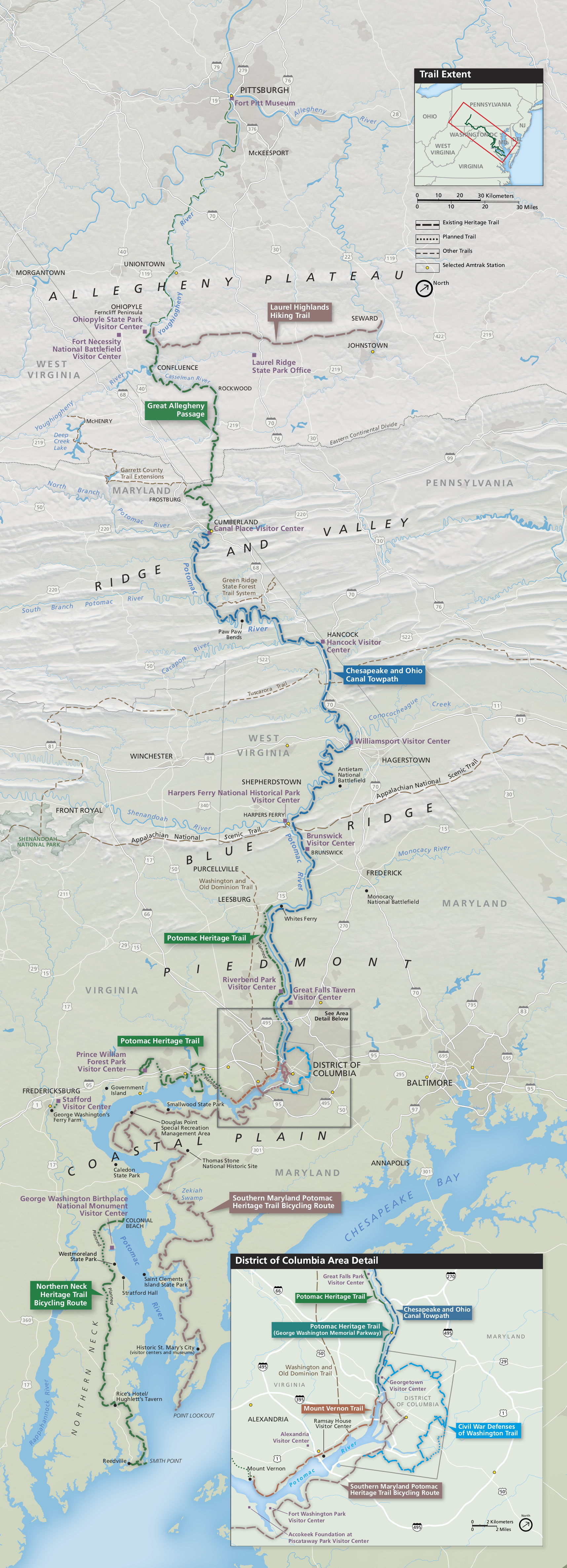 This Potomac Heritage National Scenic Trail map (1.3 mb) shows a variety of the trails administered by the National Park Service in the mid-Atlantic region. Along with the Potomac Heritage Trail, a number of partner trails are shown too: Laurel Highlands Hiking Trail, Great Allegheny Passage, Chesapeake and Ohio Canal Towpath (aka “C&O Canal”), and a few in Washington, D.C., eastern Maryland, and Virginia.
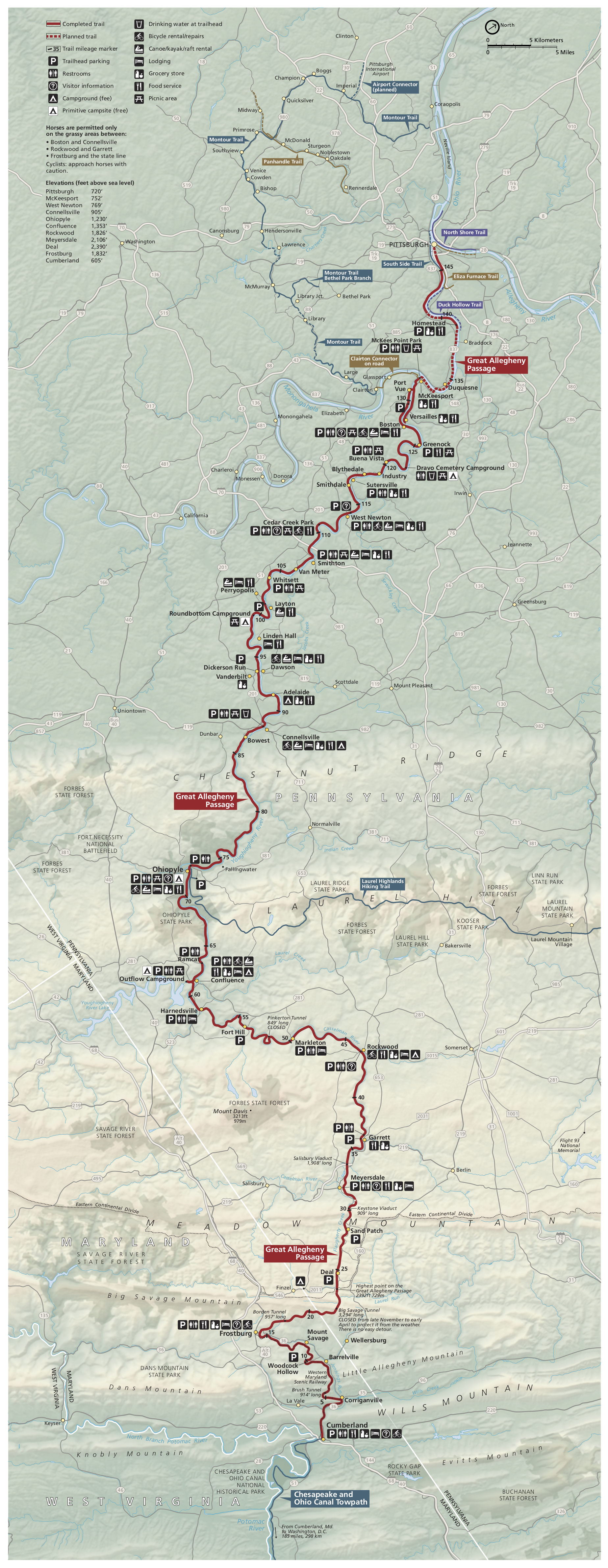 The Great Allegheny Passage Trail map zooms in on this trail, also shown in the map above. It connects Pittsburgh with the C&O Canal Towpath trail along a former railroad grade. I find this map especially handy because it labels services along the way: parking, restrooms, food, camping, lodging, etc. This is a great opportunity for a long-distance bike ride! Click the image to view a full size JPG (1.4 mb) or download the PDF (5.2 mb).
Santa Fe Trail map
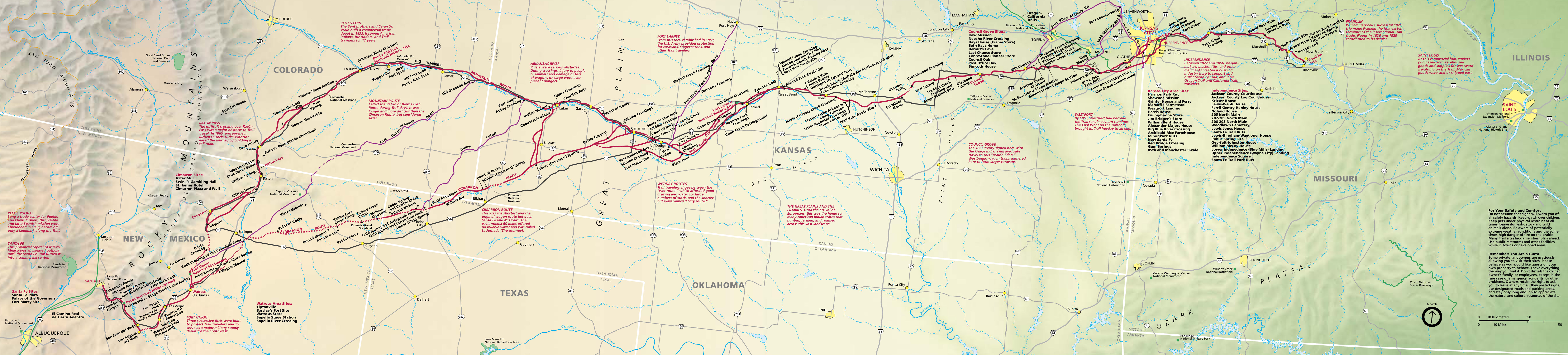 The Santa Fe National Historic Trail map shows this important route connecting the southwest United States: from Missouri, through Kansas, Oklahoma, Colorado, and New Mexico. This map displays the various routes of the trail network and highlights an auto tour route that best follows the trail. Additional text descriptions provide some educational background too. Click the image to view a full size JPG (2.5 mb) or download the PDF (650 kb).
Trail of Tears map
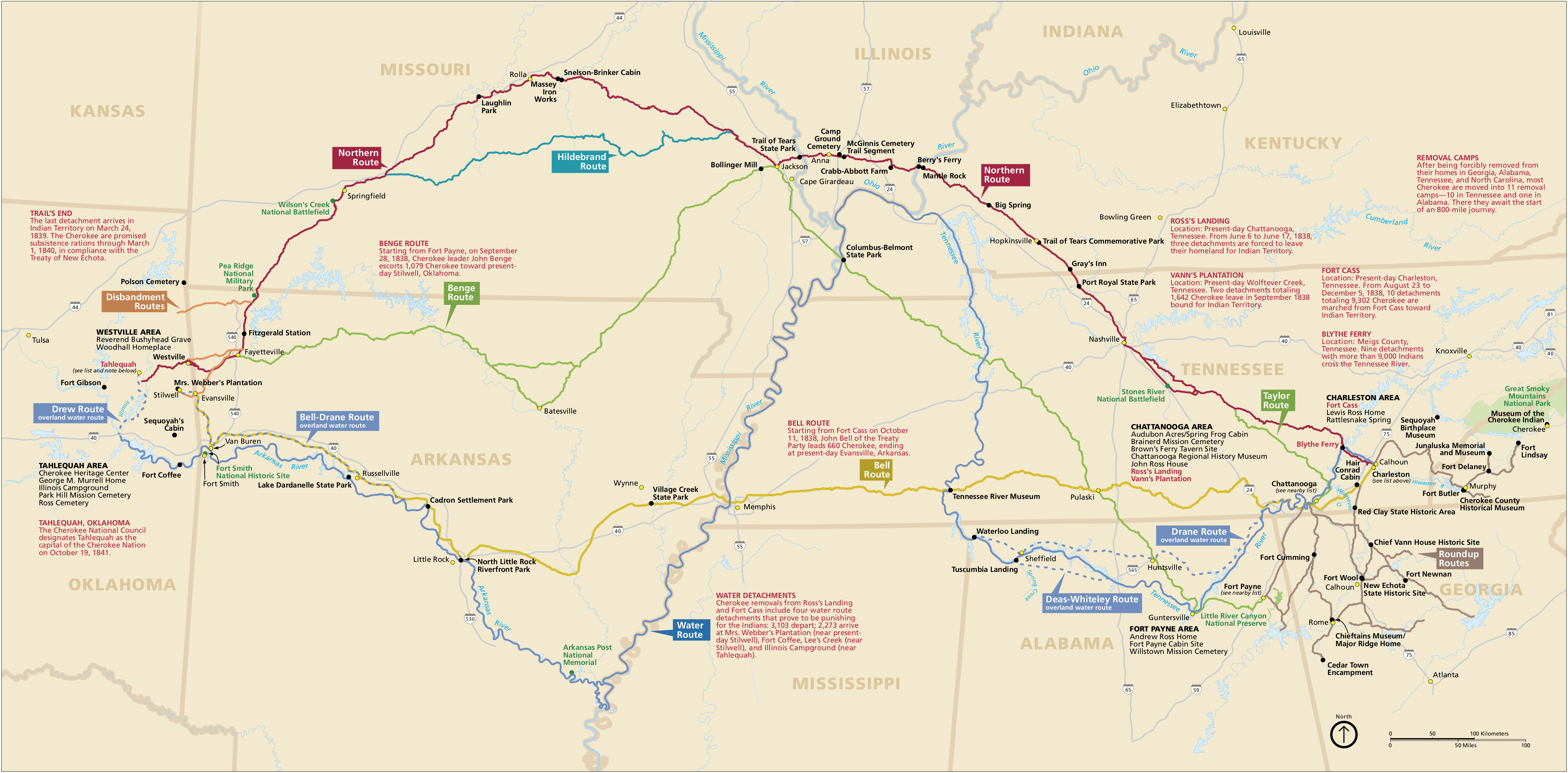 The Trail of Tears map shows one of the most shameful episodes of American history, today preserved as the Trail of Tears National Historic Trail. Although there were many forced relocations of tribes over the years, this map focuses primarily on the relocation of the Cherokee from Georgia, Alabama, and Tennessee to the Oklahoma territory in 1838-39. Click the image to view a full size GIF (800 kb) or download the PDF (2.1 mb).
…and more!
< Return to National Park Maps home
< Return to Park List
< Return to List by State