Better and better

I hope everyone is having a safe and healthy summer! With no opportunity to go on international trips, it’s a great time for Americans to stay local and visit their nearby parks.  (International visitors: we’ll see you next year.)

I’ve been updating pages with new map upgrades, adding a few dozen within the last week, with many more to come. I have to say, the National Park Service is getting better and better at publishing visually-pleasing and interesting maps. Take a look at some of the recent map edition updates:

Lassen Volcanic National Park map
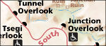
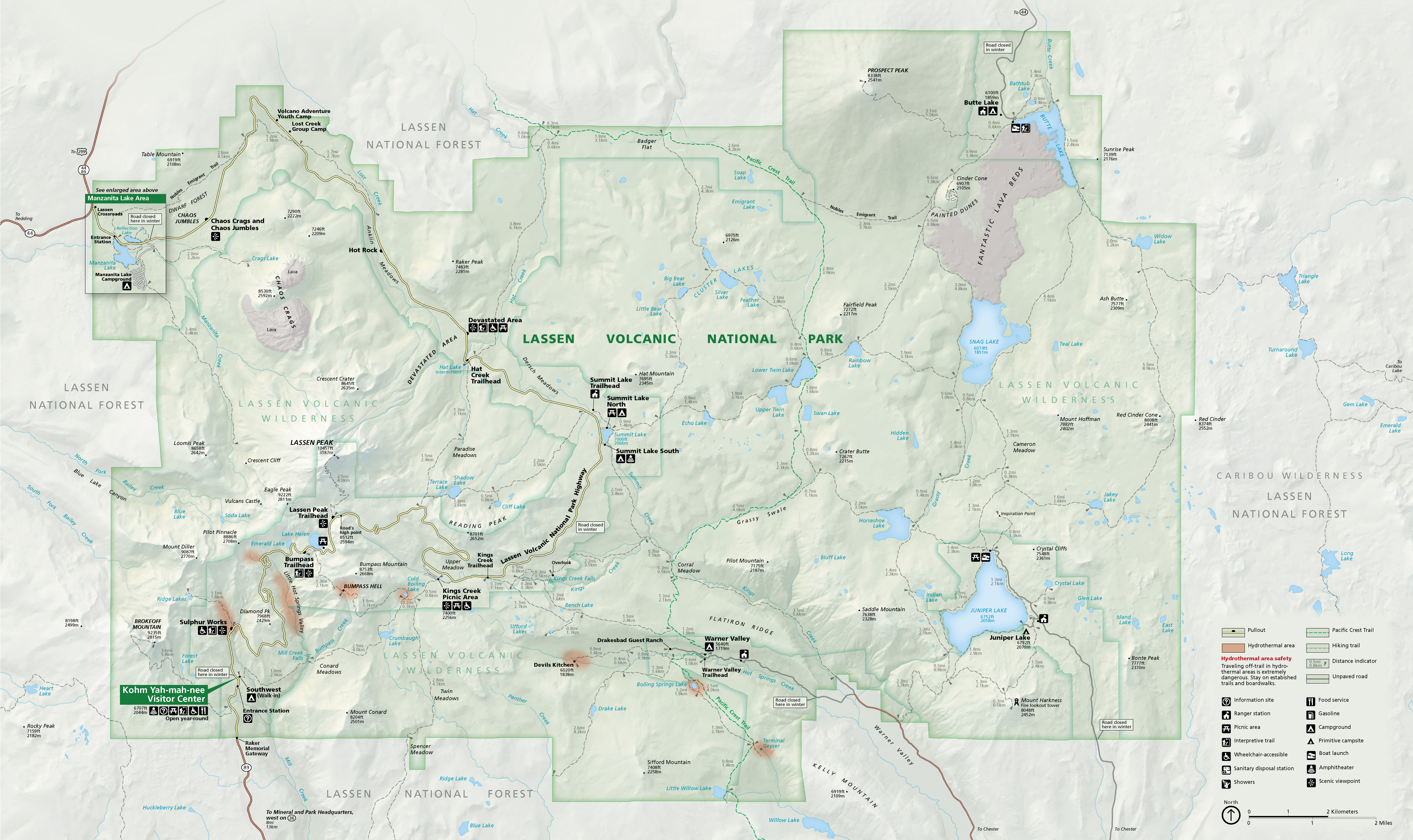
Compare the new Lassen Volcanic National Park brochure map on the left with the old one here. I love the trail mileages and topography; what a difference! View the rest of the maps on the Lassen Volcanic maps page.

Theodore Roosevelt National Park south unit
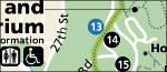
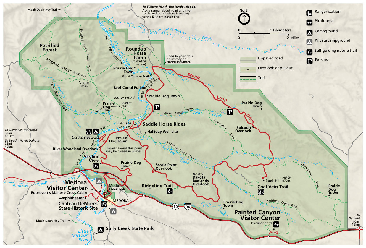
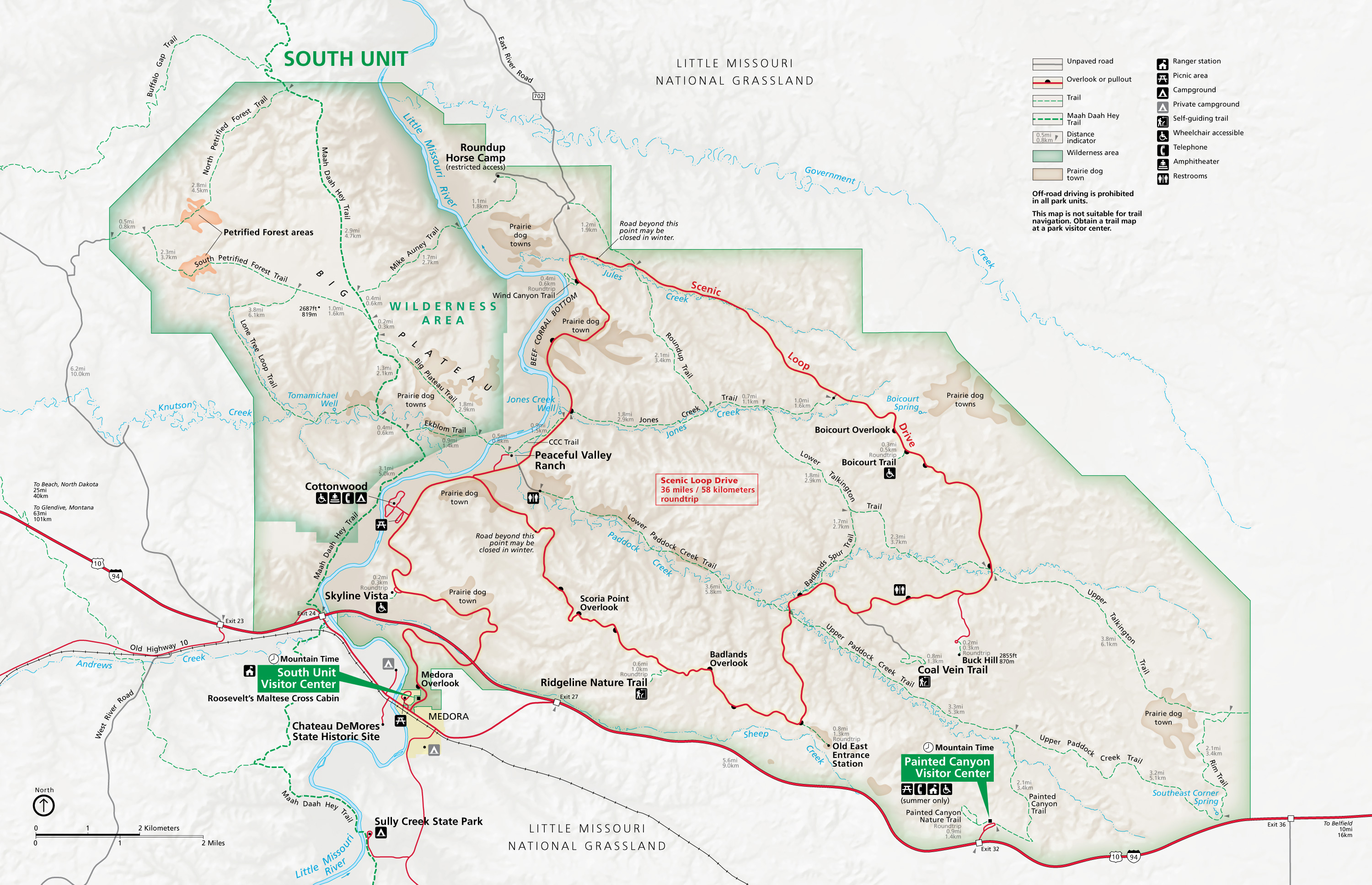
We see the same upgrades to the Theodore Roosevelt National Park brochure maps. To the left is the new South Unit map, and here’s the old one. See other updates on the Theodore Roosevelt maps page.

Yellowstone National Park map
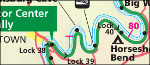
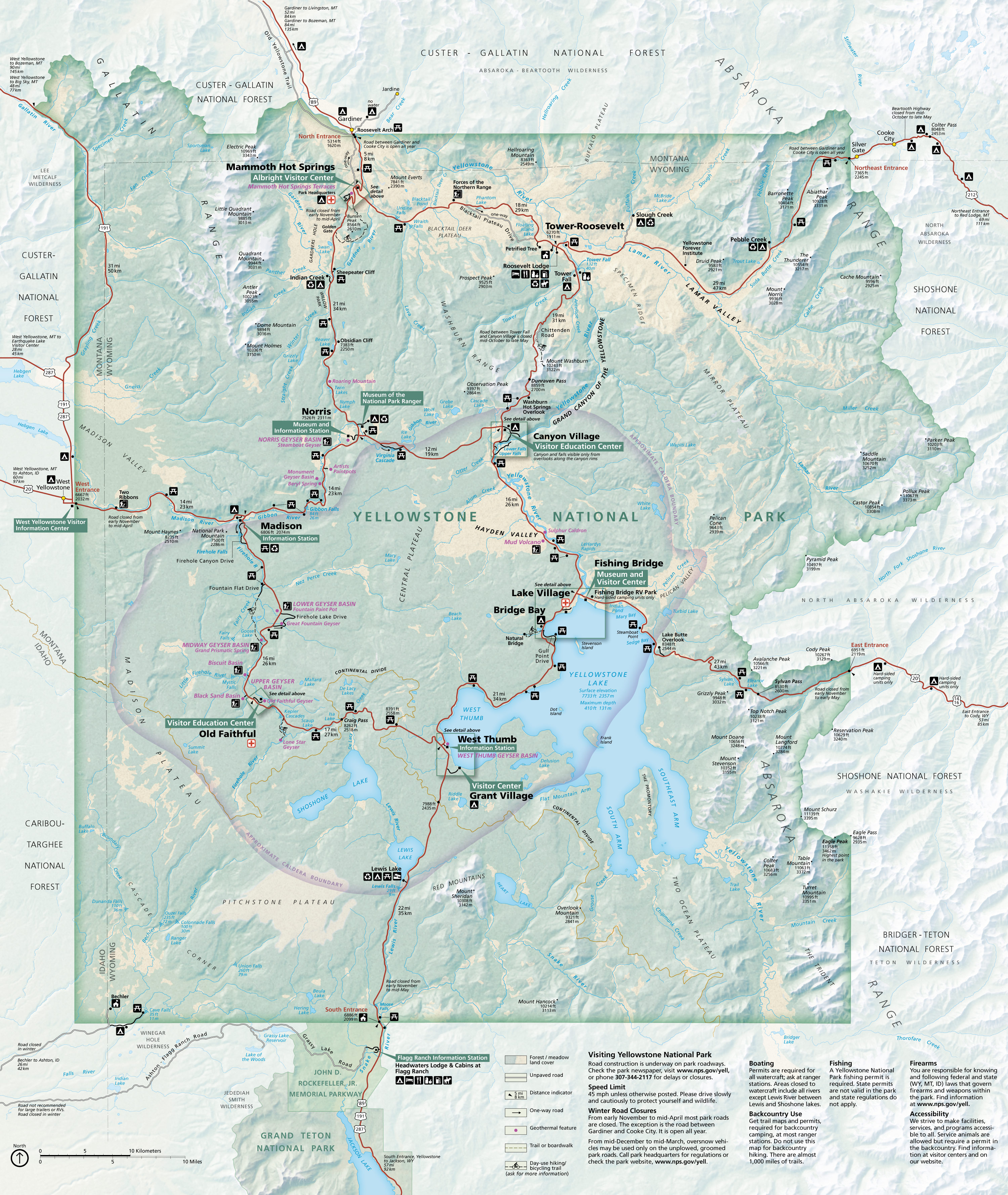
Even the grand ol’ parks like Yellowstone got facelifts! The new map is on the left and the old one is here.  Great job by the NPS maps team! View the rest of them on the Yellowstone maps page.

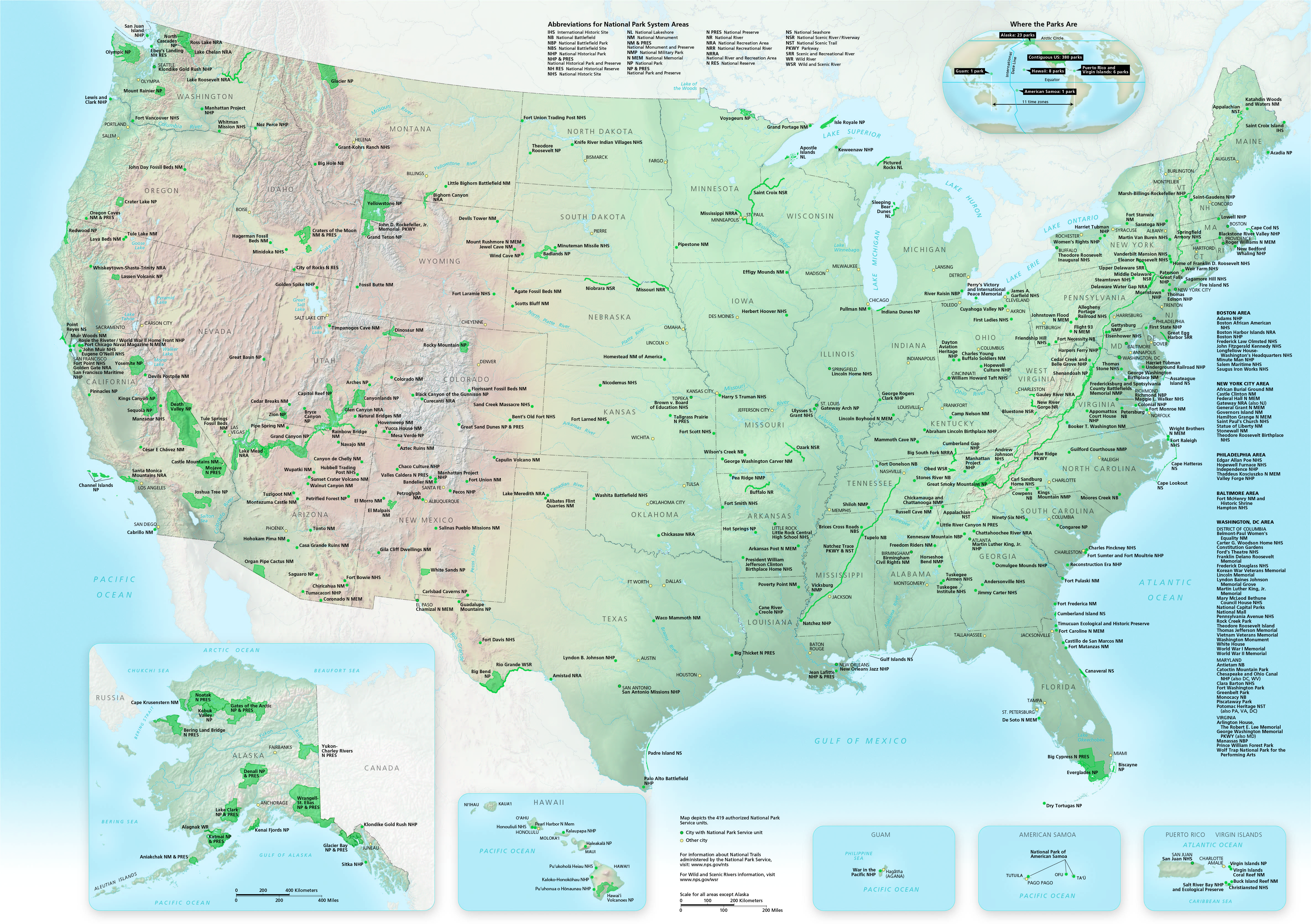
And at long last, I’ve finally got a new map of all national parks uploaded as well. This one is current as of today, featuring all 419 units.

Those are just a few examples of the many behind-the-scenes map upgrades I’ve made to this site. More to come later! And yes, I will eventually get around to creating some new pages as well — Gateway Arch National Park is feeling left out, I’m sure…

A happy update

I realize this is my first posting in quite a while, but have no fear — the site isn’t dead! As life has gotten busy, I’ve been more in “maintenance mode,” updating pages with current maps rather than creating new pages. I realize I’m a little behind, as we have two new national parks since my last update: Indiana Dunes National Lakeshore is now Indiana Dunes National Park, and Jefferson Expansion National Memorial is now Gateway Arch National Park. Stay tuned!

What I’m especially pleased with is that I can finally remove this note I’ve had on the Yosemite maps page for over three years:

Please note: starting March 2016, the National Park Service renamed some locations in the park pending the settlement of a trademark lawsuit. This page and these maps continue to refer to the traditional names, as the site author has faith that the name change will only be temporary.

The court case has now been settled, so we are seeing the return of the classic place names such as Badger Pass, Curry Village, The Ahwahnee, etc. My Yosemite maps are once again accurate!

Thanks to all those who have written in with kind words over the years. It’s nice getting an affirmation every once in a while that people are finding this site useful. Thanks, and you’re welcome!

More than 1,700 maps!

I hope everyone’s summer has gotten off to a great start full of some grand national park adventures! Personally I’ve paid visits to Canyonlands, Arches, and Rocky Mountain national parks over the last couple months, but sadly got snowed out of a recent trip to Colorado National Monument. So I’ve been busy, but got a chance to create a handful of new pages for you as I’ve crossed the 1,700 map threshold:

Montezuma Castle mapMontezuma Castle Maps. Ever been to Montezuma Castle National Monument? This small park is just off I-17 between Flagstaff and Phoenix and makes a nice stop-off if you’ve never been.

Pearl Harbor mapPearl Harbor Maps. Technically this park is called World War II Valor in the Pacific National Monument… but that’s just too much. I called the page Pearl Harbor Maps instead and added 12 maps for now.

Regional Canaveral mapCanaveral Maps. No, these aren’t maps of the really famous stuff at Cape Canaveral, like Kennedy Space Center. This page instead features 7 maps of nearby Canaveral National Seashore.

Fossil Butte mapFossil Butte Maps. Fossil Butte National Monument is one of the quietest parks I’ve ever personally visited, located in a pretty empty stretch of Wyoming near the industrial town of Kemmerer. Here are 9 maps to start.

Washita Battlefield mapWashita Battlefield Maps. Finally: my first page featuring an Oklahoma park! Washita Battlefield National Historic Site preserves a small piece of the sad history of American troops warring with tribes.

Cumberland Island mapCumberland Island Maps. It can be difficult to get a wilderness experience on the east coast, but Cumberland Island National Seashore preserves pristine coastline that was once threatened with development.

Padre Island regional mapPadre Island Maps. This should not be confused with South Padre Island! Although they’re nearby, Padre Island National Seashore has a slightly different visitor experience than the parties you’ll find on South Padre.

Operation: Thank A Ranger

Since my last update, I’ve added another five parks to this site. But before I introduce those pages as I traditionally do in these updates, I wanted to instead share with you a couple non-map pages I’ve created. The first is Operation: Thank A Ranger.

OK, maybe that’s a silly name. Whatever. I created this new page after receiving an email last week from a site visitor that included the following:

My fellow co-workers and I are concerned about the future of our national parks — specifically regarding their funding and land protection. We are finding ways/places to donate both our time and money to help preserve and support — do you have any favorites or suggestions?

I pondered on this for a while, trying to avoid responding with the traditional “volunteer for x, support organization y.” Eventually I came up with what I thought was a nice idea, replied to the email, and went on about my life.

Thank you cardsBut I soon realized my idea would work much better if a critical mass was reached. I wanted to share my idea with others, so I got to work, spent hours organizing and compiling links, and put together my new Thank A Ranger page. Check it out! I won’t repeat that whole page here, but the gist is that I’d love it if we could show our support to park employees by writing them letters of support and appreciation — helpful reminders for those dealing with record crowds and questions about the future of their agency.

On the Thank a Ranger page you’ll find links to the contact information of every national park, sorted by state. In case you’d rather see a full list of parks alphabetically, I also created the Contact A Park page. This page should be super-helpful for those of you want to have official brochures and maps sent to your home, as parks will generally send those upon request. Keep these two pages handy and you’ll be able to get your trips planned faster.

OK, enough blabbing — what new pages have I created?

Flight 93 Memorial mapFlight 93 Maps. Did you even know Flight 93 National Memorial existed? As you can imagine, it’s one of our newer national park units, and the only one related to the tragic events of September 11, 2001.

Natural Bridges National Monument mapNatural Bridges Maps. If you’re looking for dark night skies, Natural Bridges National Monument may be your best bet as the first International Dark Sky Park.

San Antonio Missions mapSan Antonio Missions Maps. I’ve finally got so many large natural park pages uploaded that I get to spend time working on historical parks! Stay tuned for a much larger percentage of them from here on out.

C&O Canal mapC&O Canal Maps. Like this one. Although many visitors go to the C&O Canal for running, biking, and outdoor activities, the park actually protects the historic canal and towpath, so important in the 1800s.

Rock Creek Park mapRock Creek Park Maps. And I always have a soft spot in my heart for urban parks such as Rock Creek. Not everyone can afford to travel to large western parks; here, the rangers can come to them.

That’s it for this update! As a reminder, you can keep abreast with the latest updates here by following me on Facebook or on Twitter.

New parks and features

Hey, look at that! Just a week since my last update. I know web traffic will be picking up as we get close to summer, so I’m trying to make a number of behind-the-scenes tweaks and fixes to make sure things are working smoothly. I’ve added a few pages since the last update:

Santa Fe Trail mapHere’s a completely brand new type of page: National Trails maps. The National Park Service manages a bunch of National Scenic and National Historic trails, many of which extend through several states. Instead of creating each trail on a separate page (which I will likely get to later), for now I put them all on a single page together. I quite like it – these are some very large maps that are fun to scroll through and study.

Haleakala mapI created another new page that didn’t result in me adding new maps… but I had fun anyway picking out a selection for the My Favorite Maps page. To be honest, I don’t really have any strong reason for creating this page; no one’s been asking me, “Hey, what are your favorite maps?” Really, it just came down to the fact that I really love maps and wanted to call special attention to those I thought were really well done. What more reason can you need?

Canyon de Chelly mapI’m making more progress on Arizona parks, with Canyon de Chelly maps finally going live. This is a unique park managed in cooperation with Navajo Parks and Recreation, as it is on tribal land.

Walnut Canyon trail mapAnd yes, I did complete the last of the three Flagstaff-area parks with
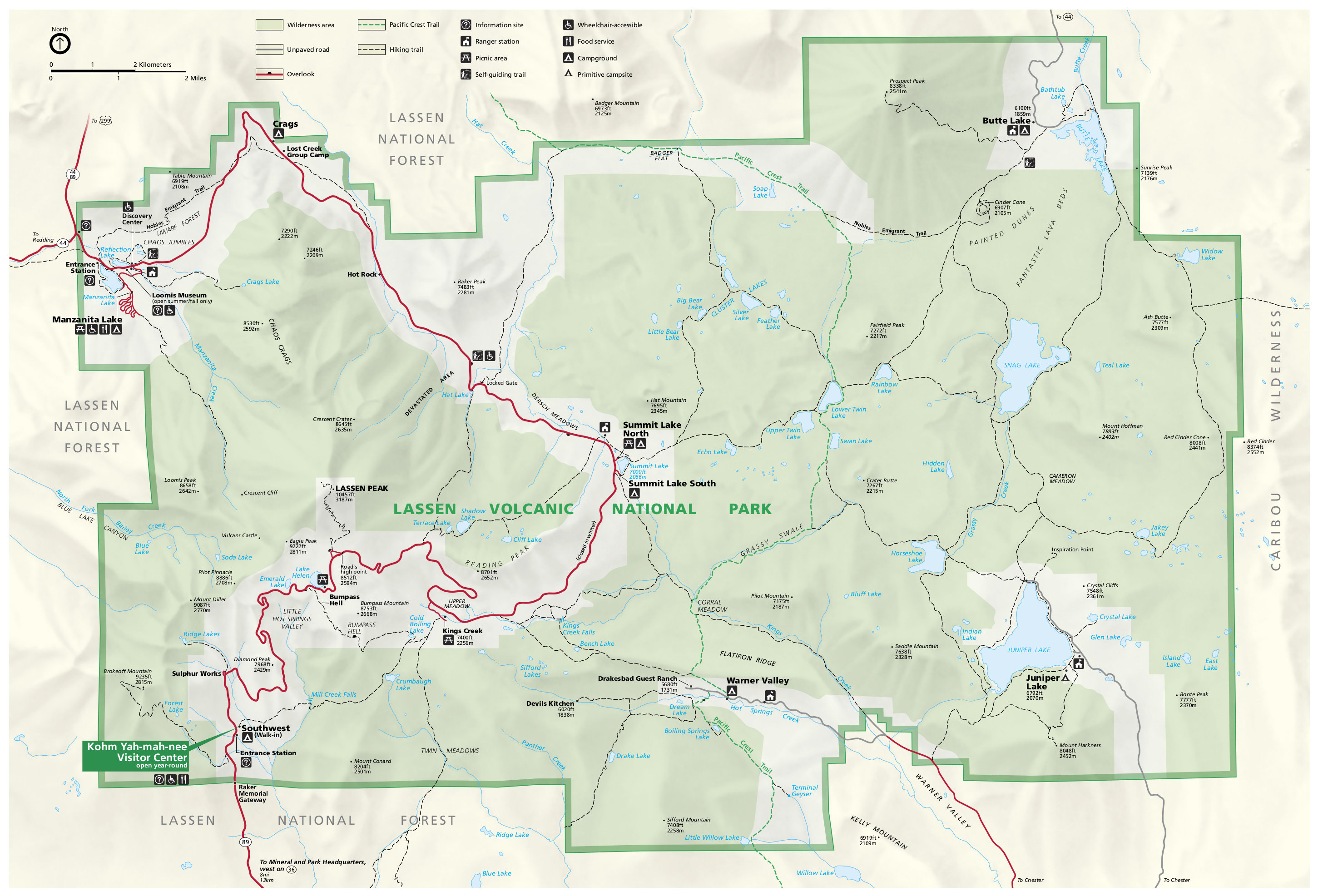
 Walnut Canyon maps. Did you know that Walnut Canyon is managed with Sunset Crater and Wupatki as effectively one park? (Now you know.)

Finally, I put up an In The News page. I’m not really a big fan of talking about myself and rather enjoy semi-anonymity, but I know from emails I’ve received that people are curious. So you can browse through some articles that featured this site if you want to learn more.